

Blizzard of 93
-
Posts
13,045 -
Joined
-
Last visited
Content Type
Profiles
Blogs
Forums
American Weather
Media Demo
Store
Gallery
Everything posted by Blizzard of 93
-
Central PA Winter 25/26 Discussion and Obs
Blizzard of 93 replied to MAG5035's topic in Upstate New York/Pennsylvania
I’ve looked at a lot of snow maps in my lifetime, but I’m not sure if I’ve ever seen a 16 day map for Central PA that produced these insane amounts. I think most would be thrilled if we approached near 1 foot in the next 16 days… -
Central PA Winter 25/26 Discussion and Obs
Blizzard of 93 replied to MAG5035's topic in Upstate New York/Pennsylvania
Moving forward, the pattern looks active in week 2, with perhaps a chance of some moisture laden storms approaching from the south & west, instead of this never ending Clipper parade that we’ve had since mid December. There should be cold air around to tap into, so hopefully we can reel in something specific to track for later in the month. -
Central PA Winter 25/26 Discussion and Obs
Blizzard of 93 replied to MAG5035's topic in Upstate New York/Pennsylvania
Not what most of us were hoping for this week, especially with the way several model runs had been trending. Hopefully we at least see some snow in the air & maybe a coating for some. -
Central PA Winter 25/26 Discussion and Obs
Blizzard of 93 replied to MAG5035's topic in Upstate New York/Pennsylvania
Wednesday Night A chance of rain before 4am, then a slight chance of snow. Mostly cloudy, with a low around 24. Southwest wind 5 to 14 mph becoming northwest after midnight. Winds could gust as high as 28 mph. Chance of precipitation is 50%. New snow accumulation of less than a half inch possible. -
Central PA Winter 25/26 Discussion and Obs
Blizzard of 93 replied to MAG5035's topic in Upstate New York/Pennsylvania
21 in Marysville for the low. -
Central PA Winter 25/26 Discussion and Obs
Blizzard of 93 replied to MAG5035's topic in Upstate New York/Pennsylvania
Maybe we still have an outside chance to squeeze out a light event out of one or both of these chances this week? -
Central PA Winter 25/26 Discussion and Obs
Blizzard of 93 replied to MAG5035's topic in Upstate New York/Pennsylvania
18z Euro also has more light snow on late Saturday night for much of CTP. -
Central PA Winter 25/26 Discussion and Obs
Blizzard of 93 replied to MAG5035's topic in Upstate New York/Pennsylvania
18z Euro still brings some Thursday light snow to the LSV and a couple of inches to the Williamsport area. -
Central PA Winter 25/26 Discussion and Obs
Blizzard of 93 replied to MAG5035's topic in Upstate New York/Pennsylvania
Need a comeback today on the models for the late week period. Things were looking good through 12z yesterday & then the wheels fell off. Hopefully today we see a better trend. -
Yup, I forgot it’s all over & already failed, lol… Panic room is one thread over there…
-
@TSSN+ Didn’t you just complain about @Ji complaining & derailing the thread yesterday…? You are right there with him today, lol! Maybe take a break?
-
Central PA Winter 25/26 Discussion and Obs
Blizzard of 93 replied to MAG5035's topic in Upstate New York/Pennsylvania
It Just arrived in Marysville as well. -
Central PA Winter 25/26 Discussion and Obs
Blizzard of 93 replied to MAG5035's topic in Upstate New York/Pennsylvania
-
Central PA Winter 25/26 Discussion and Obs
Blizzard of 93 replied to MAG5035's topic in Upstate New York/Pennsylvania
Best Euro run yet for the Thursday chance for the Susquehanna Valley. -
Central PA Winter 25/26 Discussion and Obs
Blizzard of 93 replied to MAG5035's topic in Upstate New York/Pennsylvania
12z GFS combined snow through Sunday night. -
Central PA Winter 25/26 Discussion and Obs
Blizzard of 93 replied to MAG5035's topic in Upstate New York/Pennsylvania
12z GFS is back this run for the Sunday chance with another CTP Advisory level event with heavier amounts to our east. Snow map is Only for the Sunday period. -
Central PA Winter 25/26 Discussion and Obs
Blizzard of 93 replied to MAG5035's topic in Upstate New York/Pennsylvania
12z GFS is an Advisory level event this run for most of us on Thursday with heavier amounts just to our south. Not a bad place to be 4 days out… -
Central PA Winter 25/26 Discussion and Obs
Blizzard of 93 replied to MAG5035's topic in Upstate New York/Pennsylvania
Thankfully Mt. Holly had a good update this evening on their discussion… KEY MESSAGE 3...Potential for a coastal storm Thursday and/or Friday. Impacts/details are very uncertain as these will depend on how close to the coast the low tracks. For Thursday and Friday, the upper air pattern is forecast to become more amplified across the East. The sharpening of an upper-level trough will develop a storm, however the details are much less certain at this time. The model consensus is pointing toward a storm, however whether this will become a coastal storm or one that simply goes out to sea is the forecast challenge. Some guidance suggests a significant winter storm while others are a miss. If the southern energy can remain out ahead of the northern stream energy along with a trough axis more neutral or becoming negatively tilted, then the surface low would tend to be closer to the coast. The guidance that has more of a positive tilted upper-level trough shear the system northeastward and keeps it out to sea. The closer to the coast scenario would favor more precipitation westward across our region, with the timing either Thursday or Friday. Given the wealth of uncertainty in the details, did not alter the forecast away from the NBM guidance. This continues to show low chances for now of rain and/or snow Thursday and Thursday night, however it currently is dry for Friday. If some of the guidance is correct, then PoPs would need to be added/increased for Friday. A colder air mass is forecast to be in place at the of next week and to start next weekend. -
Central PA Winter 25/26 Discussion and Obs
Blizzard of 93 replied to MAG5035's topic in Upstate New York/Pennsylvania
Lol, they updated it with No update. Their forecast discussion says updated 723 pm, but it must have been just a short term update. No mention in the discussion or grids of Thursday or Friday storm chances. It’s going to be a shock to some of the general population if the GFS or Euro were to verify. -
Central PA Winter 25/26 Discussion and Obs
Blizzard of 93 replied to MAG5035's topic in Upstate New York/Pennsylvania
Decent 18z Euro run for the 15th chance. -
Central PA Winter 25/26 Discussion and Obs
Blizzard of 93 replied to MAG5035's topic in Upstate New York/Pennsylvania
Yes, but I would still gladly sign for it.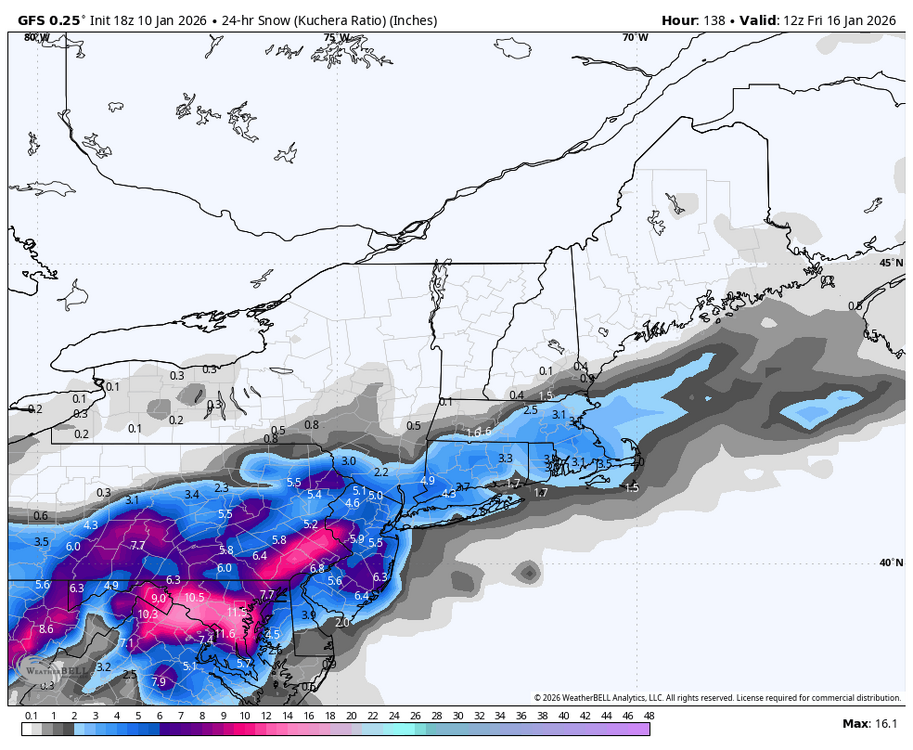
-
Central PA Winter 25/26 Discussion and Obs
Blizzard of 93 replied to MAG5035's topic in Upstate New York/Pennsylvania
Let’s go!!! I am happy you are back on here for sure! -
Central PA Winter 25/26 Discussion and Obs
Blizzard of 93 replied to MAG5035's topic in Upstate New York/Pennsylvania
It will be interesting to see if they start changing their tune with their update this evening. -
Central PA Winter 25/26 Discussion and Obs
Blizzard of 93 replied to MAG5035's topic in Upstate New York/Pennsylvania
The Euro is a miss for next weekend at this time. Nothing close this run for the second event on the 12z Euro. -
The good difference in the 12z Euro vs. the 0z Euro last night shows well in the 48 hr. total precipitation through Friday early afternoon. Quite the positive jump.


