Blizzard of 93
-
Posts
11,789 -
Joined
-
Last visited
Content Type
Profiles
Blogs
Forums
American Weather
Media Demo
Store
Gallery
Everything posted by Blizzard of 93
-
Central PA Winter 2024/2025
Blizzard of 93 replied to Voyager's topic in Upstate New York/Pennsylvania
29/17 in Marysville & cloudy -
Central PA Winter 2024/2025
Blizzard of 93 replied to Voyager's topic in Upstate New York/Pennsylvania
6z GFS brings out the system next week in a couple of waves, but delivers the goods this run. -
Central PA Winter 2024/2025
Blizzard of 93 replied to Voyager's topic in Upstate New York/Pennsylvania
0z Euro was a PA crusher for next week’s snow chance. -
Central PA Winter 2024/2025
Blizzard of 93 replied to Voyager's topic in Upstate New York/Pennsylvania
0z ICON is a hit for next week. -
Central PA Winter 2024/2025
Blizzard of 93 replied to Voyager's topic in Upstate New York/Pennsylvania
I’m trying to rest up a bit…it’s going to be a long week or so with 3 events. Fun times not far away on here. -
Central PA Winter 2024/2025
Blizzard of 93 replied to Voyager's topic in Upstate New York/Pennsylvania
To clarify, we have seen this amount on an ensemble run a couple of days before a major storm, like in 2010 or 2016. But I have not seen this amount over a 16 day ensemble run period, especially with the first major snowstorm chance being 7 days away. MU is right… Buckle Up!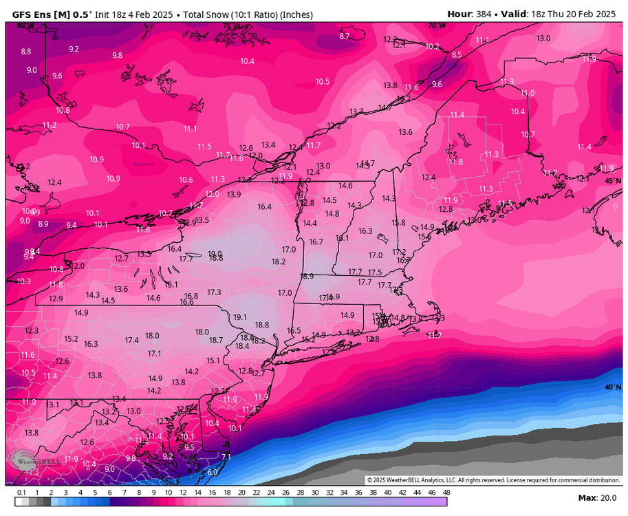
-
Central PA Winter 2024/2025
Blizzard of 93 replied to Voyager's topic in Upstate New York/Pennsylvania
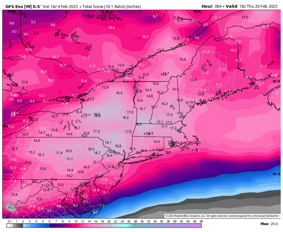
This is something that I have never ever seen in my over 20 years of following weather models closely… The 18z GEFS snow map showing over 14 inches of snow.
-
Central PA Winter 2024/2025
Blizzard of 93 replied to Voyager's topic in Upstate New York/Pennsylvania
LSV is in the jackpot for next week.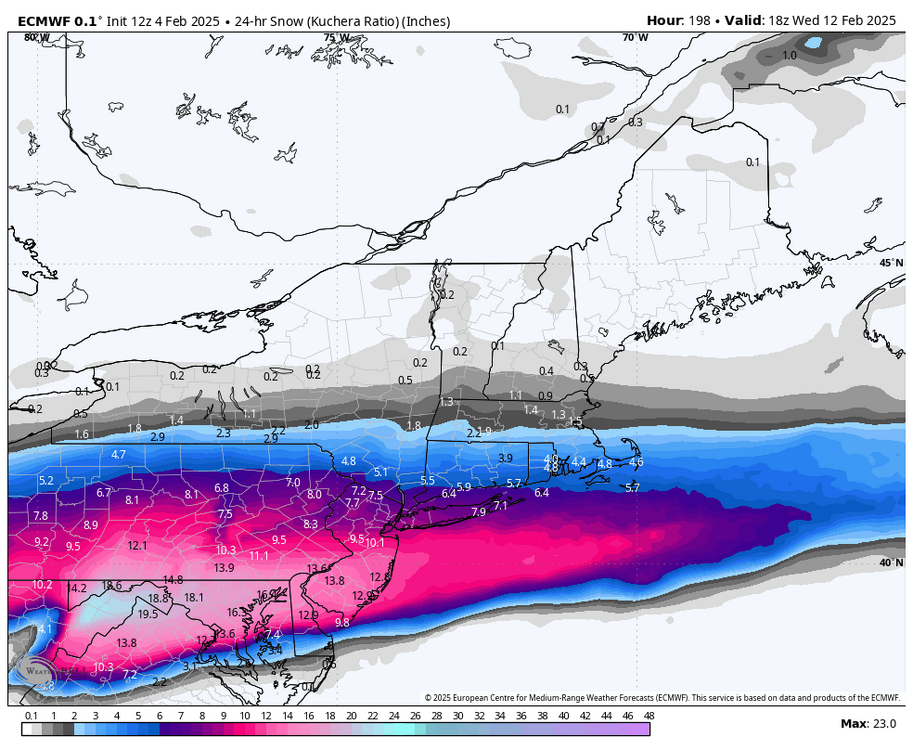
-
Central PA Winter 2024/2025
Blizzard of 93 replied to Voyager's topic in Upstate New York/Pennsylvania
-
Central PA Winter 2024/2025
Blizzard of 93 replied to Voyager's topic in Upstate New York/Pennsylvania
The overnight ensembles are still looking very encouraging for the next 2 weeks. -
Central PA Winter 2024/2025
Blizzard of 93 replied to Voyager's topic in Upstate New York/Pennsylvania
More from CTP for this first event. By Wednesday evening, broad southeast flow in the wake of retreating high pressure will keep cold air locked in east of the mountains as a warm nose of overrunning precipitation overspreads the region. The aforementioned band of snow will gradually lift northeast ahead of a broad area of low pressure moving in from the Ohio Valley with a transition to sleet and eventually freezing rain during the overnight hours. Model soundings have indicated that the layer of cold air at the surface could be a little bit deeper than previous runs, indicating potential for a longer period of sleet overnight before an inevitable transition to freezing rain. QPF amounts are generally 0.25-0.5" along and north of I-80, >0.75" in the Laurels, and 0.5-0.75" east of I-99 and south of I-80. Accounting for the expected precipitation type transitions and timing, the current forecast paints snow/sleet accumulations of up to an inch for much of central and northeast PA (higher amounts under the aforementioned Wednesday snow band), and widespread 0.10"+ ice accretion with amounts >0.25" favored in the Laurel Highlands through midday Thursday. -
Central PA Winter 2024/2025
Blizzard of 93 replied to Voyager's topic in Upstate New York/Pennsylvania
From CTP forecast discussion… Temperatures are progged to rebound considerably Thursday afternoon, though temperatures soaring into the 50s appears less and less likely as the event draws closer. It is difficult to scour out the cold air after these events, so trending below guidance seems prudent -
Central PA Winter 2024/2025
Blizzard of 93 replied to Voyager's topic in Upstate New York/Pennsylvania
The LSV holds the cold & it is tough to scour out in these icing situations. -
Central PA Winter 2024/2025
Blizzard of 93 replied to Voyager's topic in Upstate New York/Pennsylvania
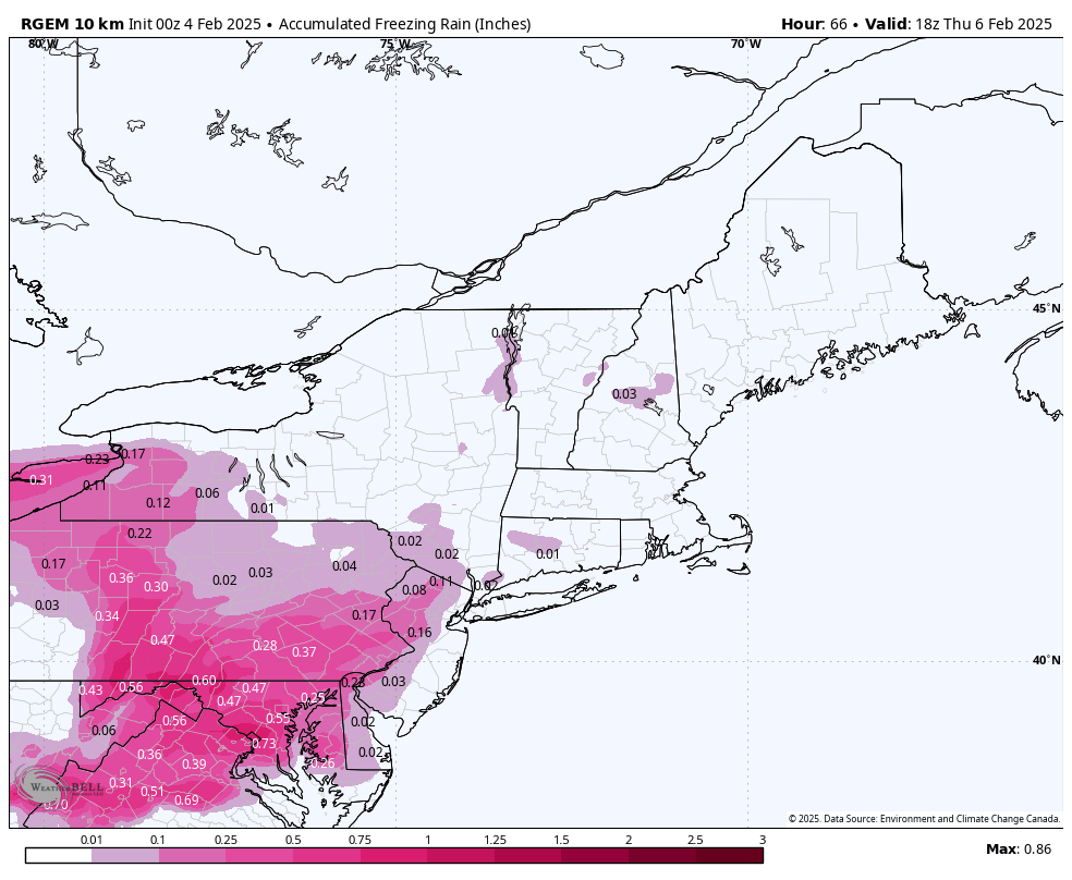
RGEM freezing rain

-
Central PA Winter 2024/2025
Blizzard of 93 replied to Voyager's topic in Upstate New York/Pennsylvania
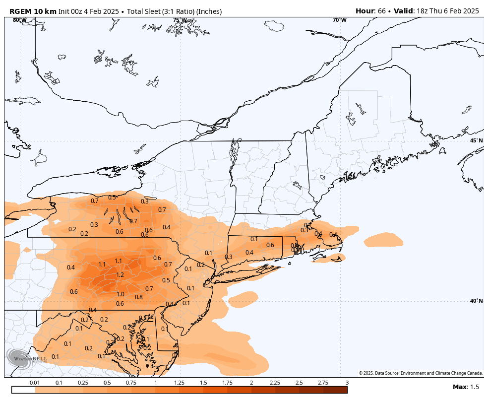
RGEM sleet
-
Central PA Winter 2024/2025
Blizzard of 93 replied to Voyager's topic in Upstate New York/Pennsylvania
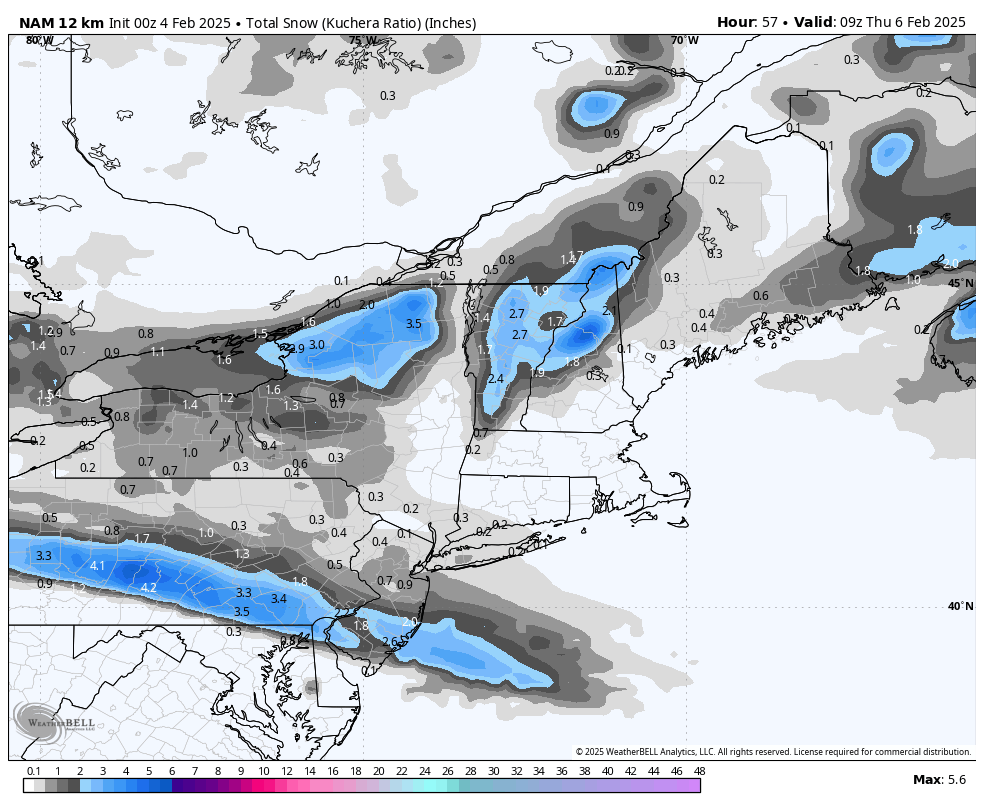
Sign me up for either NAM for this first event. I don’t mind ice storms as much if there is an inch or 2 of snow at the onset. It just makes the ice look more Wintry to me & it gives a little traction on the roads.
-
Central PA Winter 2024/2025
Blizzard of 93 replied to Voyager's topic in Upstate New York/Pennsylvania
“Ice showers”, Lol! -
Central PA Winter 2024/2025
Blizzard of 93 replied to Voyager's topic in Upstate New York/Pennsylvania
I’ve seen both NAMs disagree with each other 6 hours before game time. -
Central PA Winter 2024/2025
Blizzard of 93 replied to Voyager's topic in Upstate New York/Pennsylvania
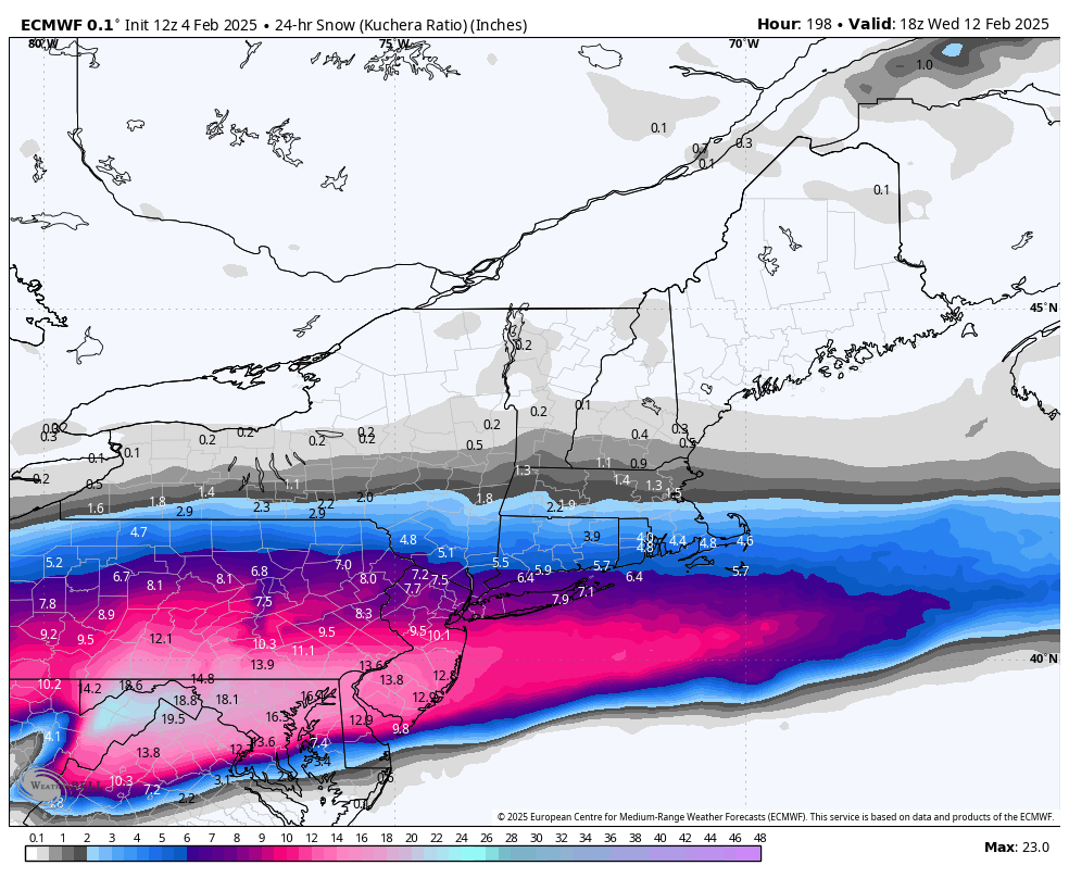
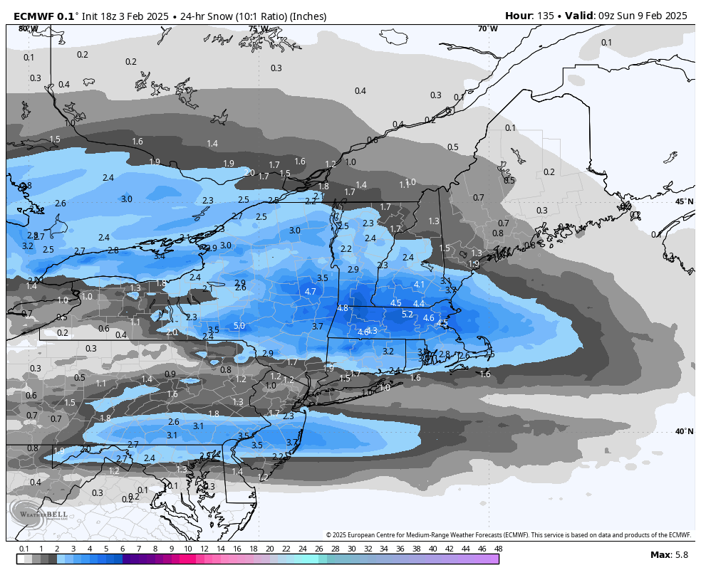
For the Saturday event, the 18z Euro has a couple of inches of snow before the ice takes over.
-
Central PA Winter 2024/2025
Blizzard of 93 replied to Voyager's topic in Upstate New York/Pennsylvania
12z GEPS & 12z EPS are also quite remarkable. The signal has been showing on the ensembles & Ops for several days now, across all major guidance. -
Central PA Winter 2024/2025
Blizzard of 93 replied to Voyager's topic in Upstate New York/Pennsylvania
18z GEFS with yet another impressive run for the 16 day period. -
Central PA Winter 2024/2025
Blizzard of 93 replied to Voyager's topic in Upstate New York/Pennsylvania
Hi! Long day at work & some early offseason indoor practice for my daughter’s softball team this evening. I’m just getting caught up on the 18z run & wow, what another glorious run. So much potential… -
Central PA Winter 2024/2025
Blizzard of 93 replied to Voyager's topic in Upstate New York/Pennsylvania
For entertainment purposes, check out the 6z GFS total snow map after the second chance later next week. Beyond drool worthy… -
Central PA Winter 2024/2025
Blizzard of 93 replied to Voyager's topic in Upstate New York/Pennsylvania
Euro has 1 significant snow chance next week mid next week as well. -
Central PA Winter 2024/2025
Blizzard of 93 replied to Voyager's topic in Upstate New York/Pennsylvania
After the two icy mix chances this week, the 6z GFS has 2 significant snow chances next week. These chances keep showing up day after day for this period on OPs & ensembles.