Blizzard of 93
-
Posts
12,839 -
Joined
-
Last visited
Content Type
Profiles
Blogs
Forums
American Weather
Media Demo
Store
Gallery
Everything posted by Blizzard of 93
-
Central PA Winter 25/26 Discussion and Obs
Blizzard of 93 replied to MAG5035's topic in Upstate New York/Pennsylvania
Also, looks a lot like the Euro. -
Central PA Winter 25/26 Discussion and Obs
Blizzard of 93 replied to MAG5035's topic in Upstate New York/Pennsylvania
Looks a lot like the Euro… -
Central PA Winter 25/26 Discussion and Obs
Blizzard of 93 replied to MAG5035's topic in Upstate New York/Pennsylvania
Yes, towards the end of the storm tomorrow evening… -
Central PA Winter 25/26 Discussion and Obs
Blizzard of 93 replied to MAG5035's topic in Upstate New York/Pennsylvania
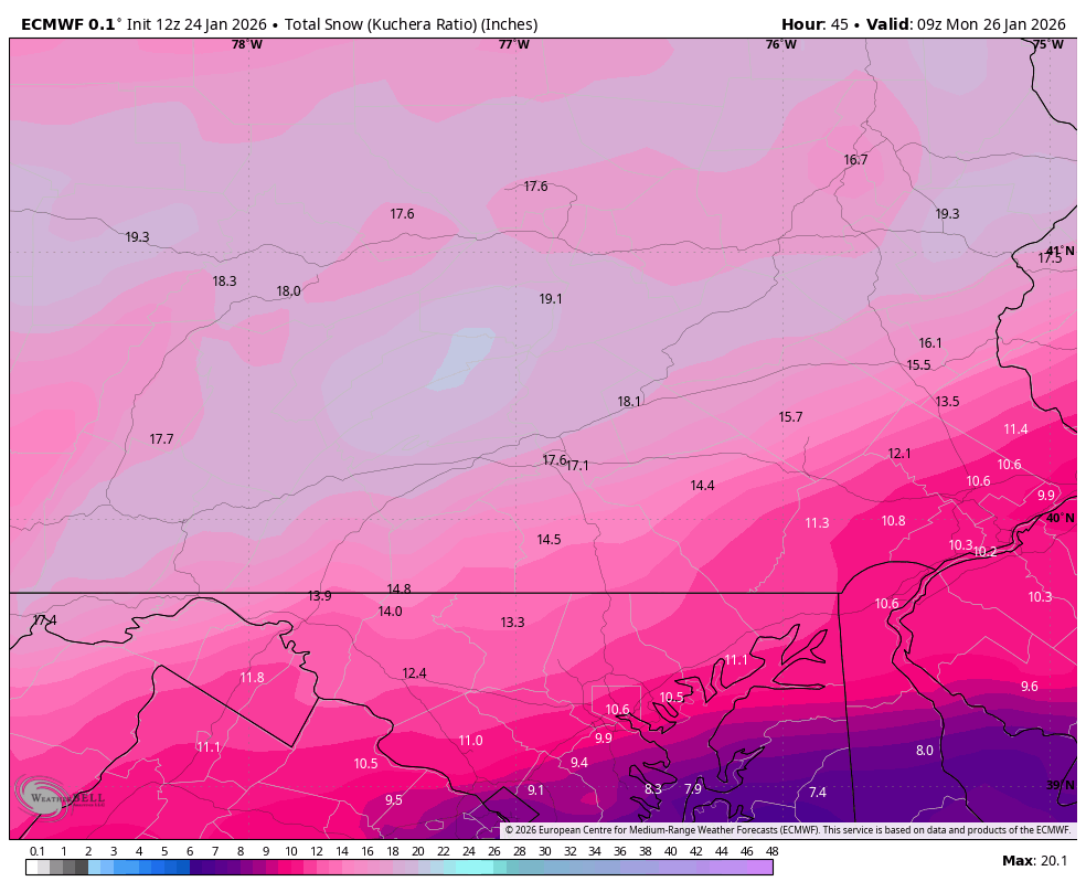
From our old friend @MillvilleWx posted recently in the Mid Atlantic thread. Final Forecast for the Storm Some adjustments were made to reduce snow a touch and increase sleet which is a lower ratio component of the forecast. Still will be a formidable storm with some ice accretion added for good measure. A lot of the snowfall range should be take for a south to north crescendo with higher ranges more likely to the north of the lines presented. Will not be perfect by any stretch, but gives a good proxy. High impact event regardless as cold air behind the storm is very legit and we will struggle to break freezing for several days post storm. Be warm and safe everyone! -
Central PA Winter 25/26 Discussion and Obs
Blizzard of 93 replied to MAG5035's topic in Upstate New York/Pennsylvania
From our long lost friend @mitchnick in the other thread… No GGEM or RGEM, but the Geps updated and here's its snowfall. Not bad folks. EDIT: Obviously includes sleet at 10:1 -
Central PA Winter 25/26 Discussion and Obs
Blizzard of 93 replied to MAG5035's topic in Upstate New York/Pennsylvania
The Euro this close in should always be factored in to me. -
Central PA Winter 25/26 Discussion and Obs
Blizzard of 93 replied to MAG5035's topic in Upstate New York/Pennsylvania
CTP close up of the Euro.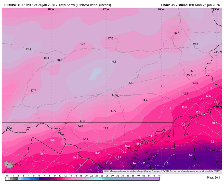
-
Central PA Winter 25/26 Discussion and Obs
Blizzard of 93 replied to MAG5035's topic in Upstate New York/Pennsylvania
Mix reaches Harrisburg, Lebanon & Carlisle by evening when precip rates begin to back off. -
Central PA Winter 25/26 Discussion and Obs
Blizzard of 93 replied to MAG5035's topic in Upstate New York/Pennsylvania
Looks like heavy, heavy snow before the mix occurs in the LSV per the Euro. -
Central PA Winter 25/26 Discussion and Obs
Blizzard of 93 replied to MAG5035's topic in Upstate New York/Pennsylvania
Next few Euro panels shows mix approaching turnpike by late afternoon & early evening. -
Central PA Winter 25/26 Discussion and Obs
Blizzard of 93 replied to MAG5035's topic in Upstate New York/Pennsylvania
12z Euro keeps All of us heavy snow through 1 pm tomorrow this run. -
Central PA Winter 25/26 Discussion and Obs
Blizzard of 93 replied to MAG5035's topic in Upstate New York/Pennsylvania
Reclaim the crown, please! -
Central PA Winter 25/26 Discussion and Obs
Blizzard of 93 replied to MAG5035's topic in Upstate New York/Pennsylvania
& I am fired up good sir & showed the goods! -
Central PA Winter 25/26 Discussion and Obs
Blizzard of 93 replied to MAG5035's topic in Upstate New York/Pennsylvania
12z Euro is NOT backing the eff down! LFG!!! -
January 24-26: Miracle or Mirage OBS Thread!
Blizzard of 93 replied to Jebman's topic in Mid Atlantic
Do you think the start time for our region might be moved up to earlier tonight based on current Obs/radar? -
Central PA Winter 25/26 Discussion and Obs
Blizzard of 93 replied to MAG5035's topic in Upstate New York/Pennsylvania
It’s good to see it’s already snowing in western Kentucky in Bowling Green last hour at 1 mile visibility. Not much virga to overcome. -
Central PA Winter 25/26 Discussion and Obs
Blizzard of 93 replied to MAG5035's topic in Upstate New York/Pennsylvania
lol, thanks, here’s what it shows for those that didn’t open the link… -
Central PA Winter 25/26 Discussion and Obs
Blizzard of 93 replied to MAG5035's topic in Upstate New York/Pennsylvania
Fake, fake news…lol! -
Central PA Winter 25/26 Discussion and Obs
Blizzard of 93 replied to MAG5035's topic in Upstate New York/Pennsylvania
SPC disagrees… Mesoscale Discussion 0043 NWS Storm Prediction Center Norman OK 0853 AM CST Sat Jan 24 2026 Areas affected...northeast TX...southern AR...northern LA...western MS Concerning...Winter mixed precipitation Valid 241453Z - 242000Z SUMMARY...Moderate to heavy freezing rain and sleet are expected to persist across the Ark-La-Tex to Ark-La-Miss regions into early afternoon. Liquid-equivalent precipitation rates of a tenth to quarter-inch per hour should be common, locally up to a half-inch per hour. DISCUSSION...A swath of moderate to heavy mixed precipitation is ongoing across east TX and the Ark-La-Tex. Surface observations confirm hourly precipitation rates of .10-.25 in/hr are common, up to around .50 in/hr. 12Z guidance is rather consistent in indicating this swath of precip persisting through at least early afternoon, gradually shifting east-northeast amid rather pronounced low-level warm theta-e advection. A classic freezing rain to sleet sounding was sampled at 12Z in SHV. This type of thermodynamic profile should continue to steadily push southward in northern LA. Farther east, the surface freezing line should only drift to nearly stall across western MS into the early afternoon. ..Grams.. 01/24/2026 -
Central PA Winter 25/26 Discussion and Obs
Blizzard of 93 replied to MAG5035's topic in Upstate New York/Pennsylvania
Classic cave! This does Not count for the contest, lol! -
Central PA Winter 25/26 Discussion and Obs
Blizzard of 93 replied to MAG5035's topic in Upstate New York/Pennsylvania
Here are the last 2 panels with anything significant, things lighten up by late evening for most.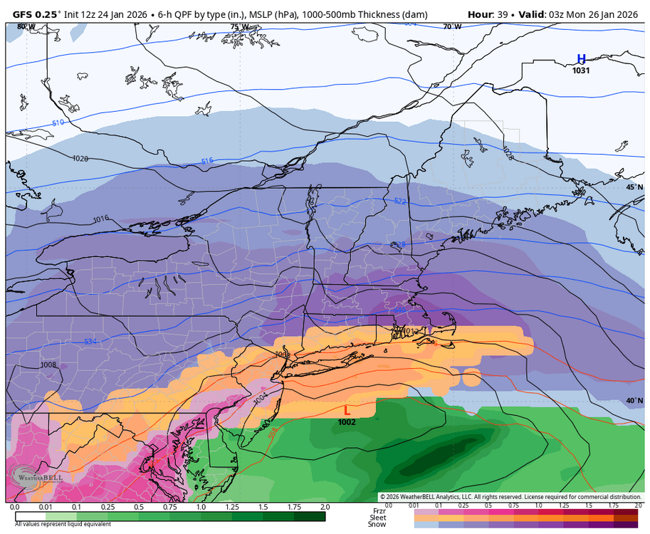
-
Central PA Winter 25/26 Discussion and Obs
Blizzard of 93 replied to MAG5035's topic in Upstate New York/Pennsylvania
12 to 16 on GFS for Harrisburg, York & Lancaster reporting stations this run. GFS is mostly noise level changes. -
Central PA Winter 25/26 Discussion and Obs
Blizzard of 93 replied to MAG5035's topic in Upstate New York/Pennsylvania
Mix back through I-81 by tomorrow early evening. -
Central PA Winter 25/26 Discussion and Obs
Blizzard of 93 replied to MAG5035's topic in Upstate New York/Pennsylvania
21z tomorrow by 4 pm mix to around turnpike. -
Central PA Winter 25/26 Discussion and Obs
Blizzard of 93 replied to MAG5035's topic in Upstate New York/Pennsylvania
GFS is Heavy snow for all of us through 18z tomorrow