-
Posts
809 -
Joined
-
Last visited
Content Type
Profiles
Blogs
Forums
American Weather
Media Demo
Store
Gallery
Everything posted by WxMan1
-

Jan 21 - 22 Weekend SE VA and Eastern Shore Snow
WxMan1 replied to stormtracker's topic in Mid Atlantic
There was also the Boxing Day snow on Dec 26, 2004. Same day as the big Tsunami in Indonesia. I was working at the Wakefield NWS at the time. 8" in Norfolk, 13" in Newport News, and 3.1" at the Wakefield NWS. Back at my house in Chester -- less than an inch. Wild storm. -
If off of the WPC's interactive surface analysis website... https://origin.wpc.ncep.noaa.gov/html/sfc-zoom.php You can also use this one to overlay satellite imagery (data quality of course dependent on how far back you go)...just click the 'archive' tab in the upper right to get to the event you're looking for, and the tab on the upper left to choose what kind of satellite imagery you want to overlay.. https://origin.wpc.ncep.noaa.gov/html/sfc-zoomIR.php
-
It was also during Super Bowl 25, I believe the Giants vs. the Broncos. I believe the forecast for my area (West Springfield at the time) was 6-10", and we ended up getting around a foot. Fluffy stuff. At one point, DCA was getting several hours of mod-heavy snow with temps in the upper teens.
-
Yeah, it certainly looks like a cold system at low levels (surface temps in the 20s), but as we know, what do the thermals aloft look like, and in particular, the lift in the DGZ? Waaay to early to quibble over those details -- the 850/700/500/250mb setup looks terrific, as does the surface low track. Reminds me a little of the Jan 26 1987 system (2nd one)...the cold Miller A that isn't overly explosive going up the coast. At least for now..
-
Irony... There were people that couldn't believe we'd have snow and temps falling into the 20s during the day on Monday, Jan 3, with highs in the 60s the previous day. And yet here we are today, temps in the mid 20s, dewpoints 0 to -6F, and yet we could be looking at plain rain in a little over 24 hours. Just goes to show how it all comes down to the storm track (dictated by upper levels) and where the winds are blowing in from.
-
Absolutely spot on! While not the result we all want, it's such an anomalous track, which in of itself it pretty cool. My neighbors now have discovered a new way of figuring out whether or not we're going to get a big winter storm. Since the pandemic, we've had the capability of working forecast ops from home. It's a great option too when the roads are awful. So my neighbors wait to see if I'm going to work (College Park). If the meteorologist leaves his house to go to work, they know we're not getting much. I told them all yesterday I'll be driving to work, lol.
-
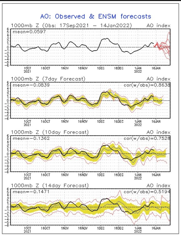
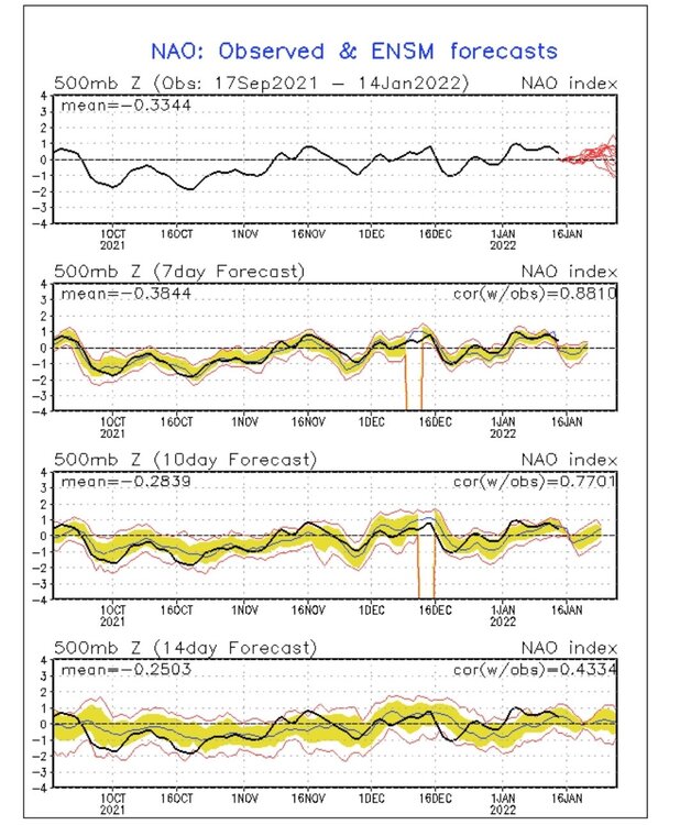
CPC earlier this morning was talking about the spread among the ensembles with respect to the AO (in particular) at 2 weeks. Pretty good polarity with some of the members, indicative of some key players that need to be resolved over the next week.
-
-
Seems like the over/under is 2-3" for many of us near/along the beltway in this setup. As noted, when the models suggest maybe 6 hours of snow, it's more like 3-4 before the mix. We can get a quick 2+ inches though because of good rates in that 3-4 hour burst.
-
I've seen this script before, as have many (all?) of you being active in this and the Eastern US weather boards over the last 15+ years. My bar along and east of 95 here in the beltway region is 2.5-3.5" before the flip. Yes, with strong WAA and a retreating high the snow always seems to come in faster. ...but then the changeover seems to happen a little quicker too. I have no issues with the GFS snow maps given what we know now.
-
Yeah, awfully tough to not given the 60-70kt winds between 925-850mb.
-
I think it's all good. Perhaps because MBY has already received 14" in Jan, including a little over 10" last Monday. With a La Niña, and being in the perfect spot 1/3, it's like playing with house $ at this point. I'd be more than happy to take 4-6" of clingy, greasy heavy wet snow while others have their turn getting heavier amounts this time around.
-
Yeah. I think we can get to 4-6" in a lot of areas with around 6 hours before the flip. Like low-end warning criteria that someone pointed out.
-
I feel like we've seen this script before so many times. But 6 hours of snow, with a couple 1-1.5"/hr rates before the flip, and overall averaging ~0.75+"/hr for that 6+ hour period = ~4-6" for a lot of us beltwayers before *hopefully* a flip to dry slot heavy drizzle vs. pouring rain.
-
You all may have touched on this already... The best case for us along/near the I95 corridor is a WAA thump that transitions to a light sleety/rain mix, or even better, drizzly dry slot, so the rain doesn't wash all the snow away. We've seen setups like this over the past several years, where that heavy rain phase doesn't come to fruition because of the timing of the transfer and a more pervasive dry slot than what was originally advertised 5 days out. I'll gladly take 4-6" of a WAA thump followed by drizzle.
-
Amen. Saw that with the Feb 2014 storm. Was around 20 or in the lower 20s when the snow began. Thought it would take a long while, then the winds started shifting from the east and picked up. Temps climbed into the lower 30s very quickly.
-
Yeah, the 02/2014 system was definitely a climatological Miller A for us. IMBY (Crofton/central AA County), we had 7.5" WAA snow to start, and at the onset it was oh so cold, then the flip to sleet, rain, and drizzly dry slot. But the best part about it was the 3-5" of backside CCB snows the following day (afternoon). I had 11-12" total, but you folks n and w of the fall line had at least 12" with round 1 alone.
-
Model panel-by-panel play-by-play. That's when you know things are getting interesting.
-
If we are, then it's about damn time. Our last El Niño was 6 years ago. We are due.
-
Yes. The 06Z GFS has that more classic Miller A track, which would equate to a more climo snowfall distribution. In other words, MBY here near Rte 50 east of 95 would more likely have some mixing potential than be in the max snow zone this time around.
-
That's a hint of the Feb 9-11, 1973 storm that brought 23" of snow to Sumter SC. Too bad I was only 2 1/2 and don't remember a thing about it. (My Dad was stationed at Shaw AFB at the time).
-
That 12Z GFS is straight-up meteorological porn.
-
Measured 3.75" in Crofton, which along with the 10.25" on Monday 1/3, brings my seasonal total up to an even 14 inches.
-
What sucks is when you have an operational shift on site.
-
What a glorious 4-5 day period that was. In West Springfield I had 11.5" on Thursday 1/22/87, then another 11" the day and night of Super Bowl Sunday, 1/25 into the early morning hours of 1/26. Fond memories.


.thumb.png.1e12fe58ce1ddce5e6af875a4a80ebb4.png)


.thumb.png.147501549033ced12fecaba6dd8c13ed.png)
