-
Posts
809 -
Joined
-
Last visited
Content Type
Profiles
Blogs
Forums
American Weather
Media Demo
Store
Gallery
Everything posted by WxMan1
-
Jan 15-16 Storm Threat Thread: The Return of Hope??
WxMan1 replied to stormtracker's topic in Mid Atlantic
Frontogenesis with a narrow ribbon of enhanced isentropic ascent always seem to overperform with events like these when the Arctic chill follows suit. -
-

Jan 15-16 Storm Threat Thread: Do we finally win or get Saltburned?
WxMan1 replied to H2O's topic in Mid Atlantic
Oh believe me, I did too! I think it's pronounced "Foo Chi".- 425 replies
-
- 2
-

-
- jinx
- kiss of death
-
(and 3 more)
Tagged with:
-

Jan 15-16 Storm Threat Thread: Do we finally win or get Saltburned?
WxMan1 replied to H2O's topic in Mid Atlantic
If it helps (and no it doesn't), the 0.25 degree experimental FuXi ECMWF ML model gives our area (I think) between .15 and .25 of liquid equivalent QPF Mon night into Tue. A band of overrunning snow north of a flat wave/eventual weak low off the Mid Atlc coast. MSLP and 850 mb wind speed: https://charts.ecmwf.int/products/fuxi_medium-mslp-wind850?base_time=202401121200&projection=opencharts_north_america&valid_time=202401160600 12 hr QPF (4-5mm through 12Z Tue...another 0.5 to 1 mm through 00Z Wed...: https://charts.ecmwf.int/products/fuxi_medium-mslp-rain?base_time=202401121200&interval=12&projection=opencharts_north_america&valid_time=202401130000 This particular version has been verifying fairly well of late.- 425 replies
-
- 7
-

-
- jinx
- kiss of death
-
(and 3 more)
Tagged with:
-

Jan 15-16 Storm Threat Thread: Do we finally win or get Saltburned?
WxMan1 replied to H2O's topic in Mid Atlantic
If you're in, I'm in! Just an FYI, and not even taking into account the latest (12Z) guidance, but the probabilistic WSSI kinda sorta gives us an areal extent of what most likely would be minor impacts. We'll see. Also attached the 13Z NBM 50% percentile snow (most likely total or mode). I think, or I'd like to believe, this is a good 'floor'...with hopefully going forward an increasing trend. The main shortwave driving this event is still south of the Gulf of Alaska, well west of the WA/OR coast.- 425 replies
-
- 8
-

-

-
- jinx
- kiss of death
-
(and 3 more)
Tagged with:
-

Jan 15-16 Storm Threat Thread: Do we finally win or get Saltburned?
WxMan1 replied to H2O's topic in Mid Atlantic
Meh, good time to start a thread. I mean, it's going to be something. Even if an inch or less of cold smoke before the coldest air of the season so far. Best to get this separated from the medium range thread that will probably have other trackable systems around Jan 19-20 and beyond. I like it. LFG!- 425 replies
-
- 10
-

-
- jinx
- kiss of death
-
(and 3 more)
Tagged with:
-

Jan Medium/Long Range Disco 2: Total Obliteration is Coming
WxMan1 replied to Jebman's topic in Mid Atlantic
Those twin systems in Jan '87 were so awesome. I was 16 at the time, living in Springfield. -

Jan Medium/Long Range Disco 2: Total Obliteration is Coming
WxMan1 replied to Jebman's topic in Mid Atlantic
That's what she sa... oh nevermind. -

Jan Medium/Long Range Disco: Winter is coming
WxMan1 replied to stormtracker's topic in Mid Atlantic
SIAP...This will be the first 'test' for the growing list of machine learning runs from the ECMWF suite. Verification has been pretty good, especially for some. Not going to get the specifics (i.e. ptype, snow totals, etc.), but at least we can see what the ML runs have in terms of the track into the medium range. https://charts.ecmwf.int/?facets={"Product type"%3A["Experimental%3A Machine learning models"]} -
Well said PSUHoffman. The fact that El Niño episodes are a bit less frequent "these days" is another potentially interesting by-product of climate change. We didn't always need to have an El Niño to get lucky with a bona-fide Miller A. It does help to have that overly active so tropical jet. But I think of the A storm in Feb 2014 -- which was during a Niña winter. Matter fact, I believe so many of us would take winters of 2013-14 and 2014-15 -- both ENSO Niña or neutral yet PLENTY of productive Miller Bs that were able to reach us south of I-70 (those 3-6" events that we can't seem to buy these days). My hunch is we'll get lucky, or unlucky depending on where you live, with a slider that happens to be timed perfectly with a transient cold air surge. Much like last January. Problem with those is it's going to be quite frontogenetic -- meaning a sharp northern gradient. We happened to do well here in central AA County...areas to the south towards Fredericksburg and Southern MD even better...but that's just pure luck.
-

3/12 Event: Winters Last Hurrah at Least East of Mountains
WxMan1 replied to Weather Will's topic in Mid Atlantic
Snowing decently here in Crofton with the backside deformation banding setting up. Before the lull, we may have gotten a quarter inch or so. Happy to hear the NW-W areas doing well. For me, this winter was more than okay, especially after a disastrous December. 10.25" on January 3rd was really all I needed. That was a great storm at a great time of the season. -

January 28-29 2022 Miller abcdefu Storm Obs/Discussion
WxMan1 replied to mappy's topic in Mid Atlantic
-

January 28-29 2022 Miller abcdefu Storm Obs/Discussion
WxMan1 replied to mappy's topic in Mid Atlantic
Looking forward to the 2-4" IMBY. A little jealous of eastern New England, then again I'm not overly partial to crippling wind chills and snow drifts at the same time. Give me a foot of pasty dense snow without the brutal cold like we (almost) had Jan 3rd and I'm good. -
https://twitter.com/MikeTrout/status/1486854871743610881?t=g6qqB584yfS5ccOi5m4m1Q&s=19
-
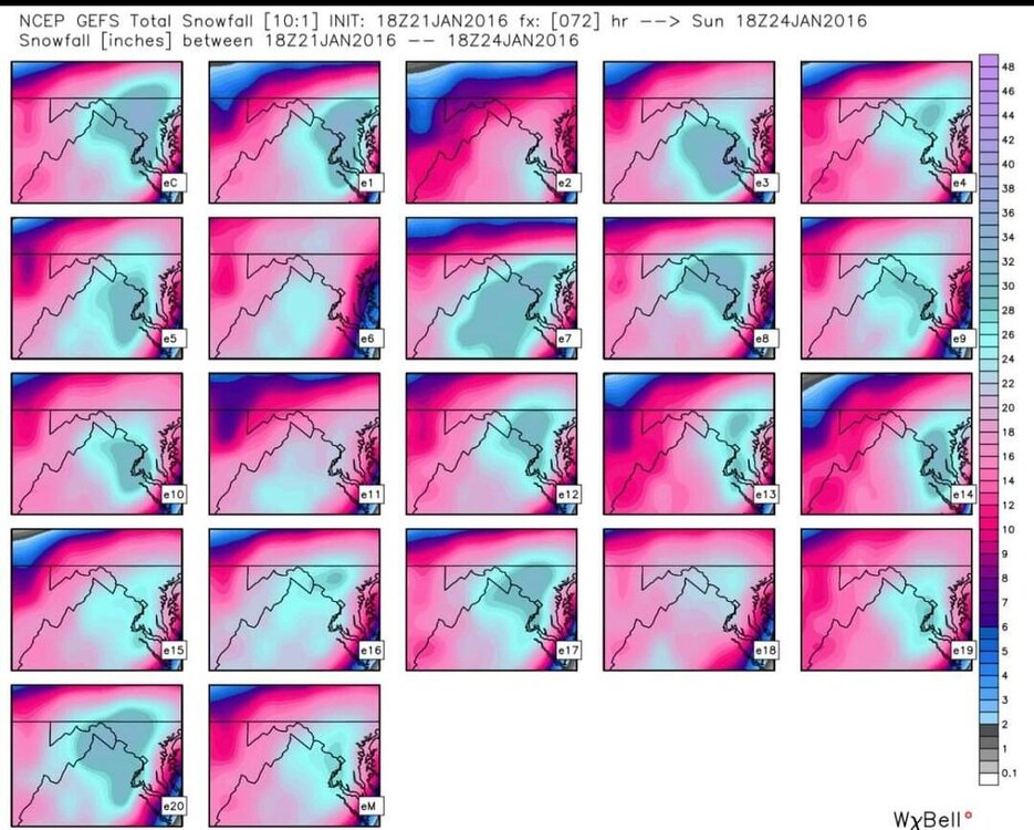
It's like a Cowboys fan (like me) recalling the glory days, now over a quarter century ago. Thankfully we don't have to wait that long for a historic, at least Top 10 snowfall around these parts. Reminisce with these GEFS panels just before the 1/22-23 event 6 years ago. Every member had at least a foot for DCA. We'll get there again someday, and it will be oh-so-sweet when it happens!
-
They're already on it...wowzers...their storm thread is over 300 pages now. I already know 2 folks flying out of BWI tomorrow to go chase.
-
Op GFS reminding us that the in-situ dry slot can be a real deal with a transfer/low deepening offshore. What's more, I think we're all wary of several hours of pixie dust snow/lack of dendritic growth and light rates when it actually does snow. I have no idea what the 'bar' for this storm is yet. 2-4" for the Beltway region? Sure, let's start there..
-
-
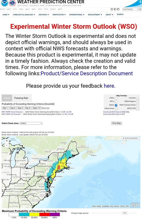
I had a heck of a time getting the cities to match up with the graphic. Thankfully the shift before last night got the key messages started. Notice how the probs went up, especially in New England. We also now see the storm in the day 4 WSO! Let's hope the probs keep going up for us!!
-
That would be a second time this winter for us easterners. I had 10.25" with the Jan 3rd system here in Crofton.
-
Hello all! I figured this forum (banter) would be as good as any to put this in. Many have been talking about Miller A vs B. A few years back we did a review of the Miller Cyclone classification system -- based off of James E. Miller's research that was published in the Journal of Meteorology (June 1946). We also applied the classification to some more recent examples (and by recent, I mean the past 10-15 years). As many of you noted, there are many "hybrid" A/B types, but even in those situations, the characteristics are going to be either A or B dominant. Not the gospel on the subject by any means, but I thought perhaps it would provide a little more clarity to the topic. Or not. Miller_Cyclogenesis_Classification_US_Atlantic_Coastal_Region.pdf
-

Thursday 1/20/22 Stat Padder Discussion and Observations
WxMan1 replied to stormtracker's topic in Mid Atlantic
GFS is pretty bullish with the snow *fall*, but this could be one of those instances (ground sfc temps initially) where the actual snow is closer to the pos snow depth change map, or something between the two.. -

Thursday 1/20/22 Stat Padder Discussion and Observations
WxMan1 replied to stormtracker's topic in Mid Atlantic
AVN's claim to fame: It NAILED the March 12-13 1993 Superstorm/Storm of the Century at least 5 days prior. It was very well forecasted, much like the Jan 22 2016 was once we got within 120 hours. -

Thursday 1/20/22 Stat Padder Discussion and Observations
WxMan1 replied to stormtracker's topic in Mid Atlantic
I hear ya. Gonna be 52. DiFax charts with the ETA, but before that, the NGM, AVN, MRF, and (*cough*) LFM. Baratropic model was a little before my time (Thank God). -
Yes, we definitely cannot sleep on that potential next Fri-Sat, 28-29th.


.png.82e680345dec85b849575f25f8d0e610.png)
.thumb.png.333a7e97f4717fe06651b2321060a5e2.png)
.thumb.png.3e6b436b6f95e49d531516d4f77d4ad4.png)
.thumb.png.ddaa5ad9f9c6b8996cfa699b42bbd158.png)

.png.484ff7c5e188383951c159e052fc040c.png)
.thumb.png.01fa9ecb6a8b0298c7376f7354ab9721.png)
.thumb.png.63fdf5d7a29ab341ef8733e73dcae59f.png)