WxMan1
-
Posts
809 -
Joined
-
Last visited
Content Type
Profiles
Blogs
Forums
American Weather
Media Demo
Store
Gallery
Everything posted by WxMan1
-
MSLP error (KM) vs. lead time for our Mid Atlantic-Northeast blizzard. Notice that at 144 to 168 hours in advance the GFS was indeed KING! But overall, this graph shows once again that the skill (utility) with the AI models is in the medium range (after FH84). However notice that with this event, the AIGFS got much worse than the AIFS and a lot of other guidance between forecast hours 90-125.
.thumb.png.89ce38dbd75210255d0d524c88049684.png)
-

Outta gas and Outta Time: Early March Winter Storm finale
WxMan1 replied to Ji's topic in Mid Atlantic
I see what the EC Kuchera is showing. But as it's progged right now synoptically, this 'feels' more like your typical 2-4" with the front end snow, then some sleet, then some FZRA/DZ to end.- 959 replies
-
- 12
-

-
FV3 never verifies well. I'm more annoyed that the 00Z RGEM sucked for all of us. Never get into sustained mod-hvy rates for a while and the precip is gone before 12Z Mon. Looks to progressive with the coastal low.
-
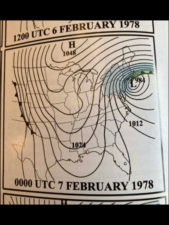
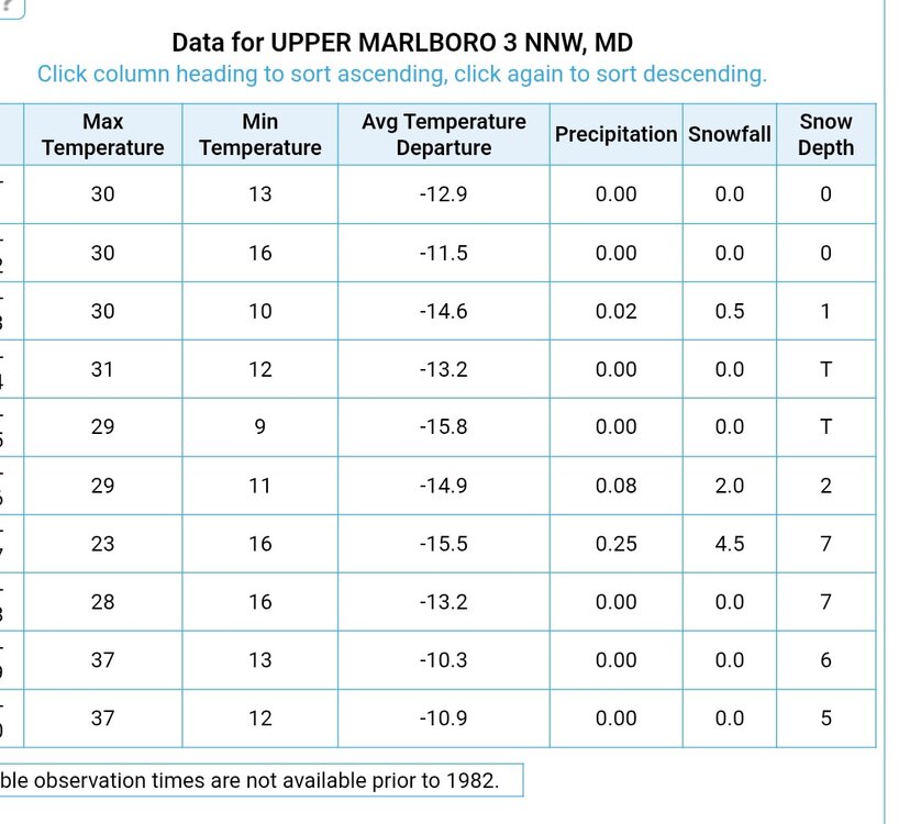
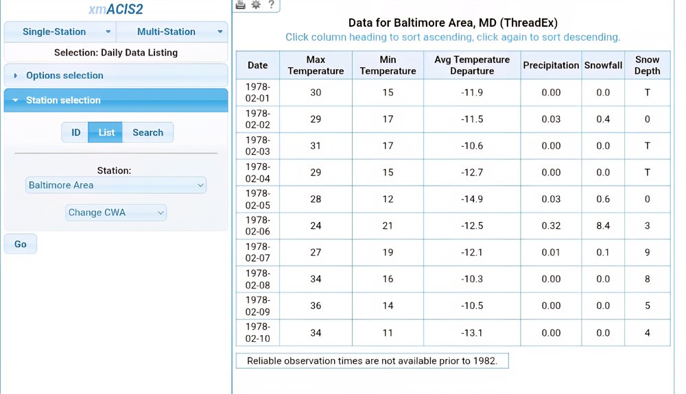
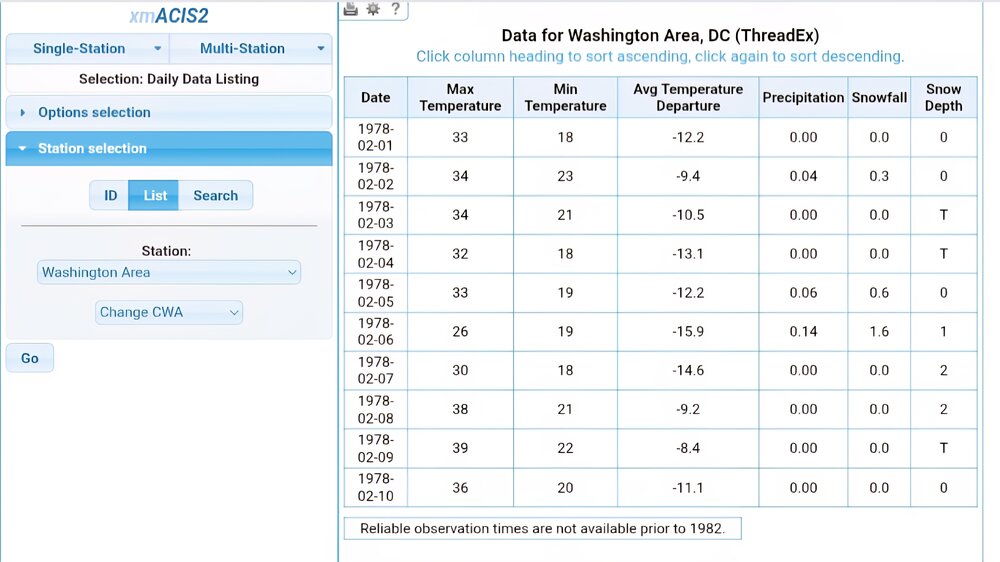
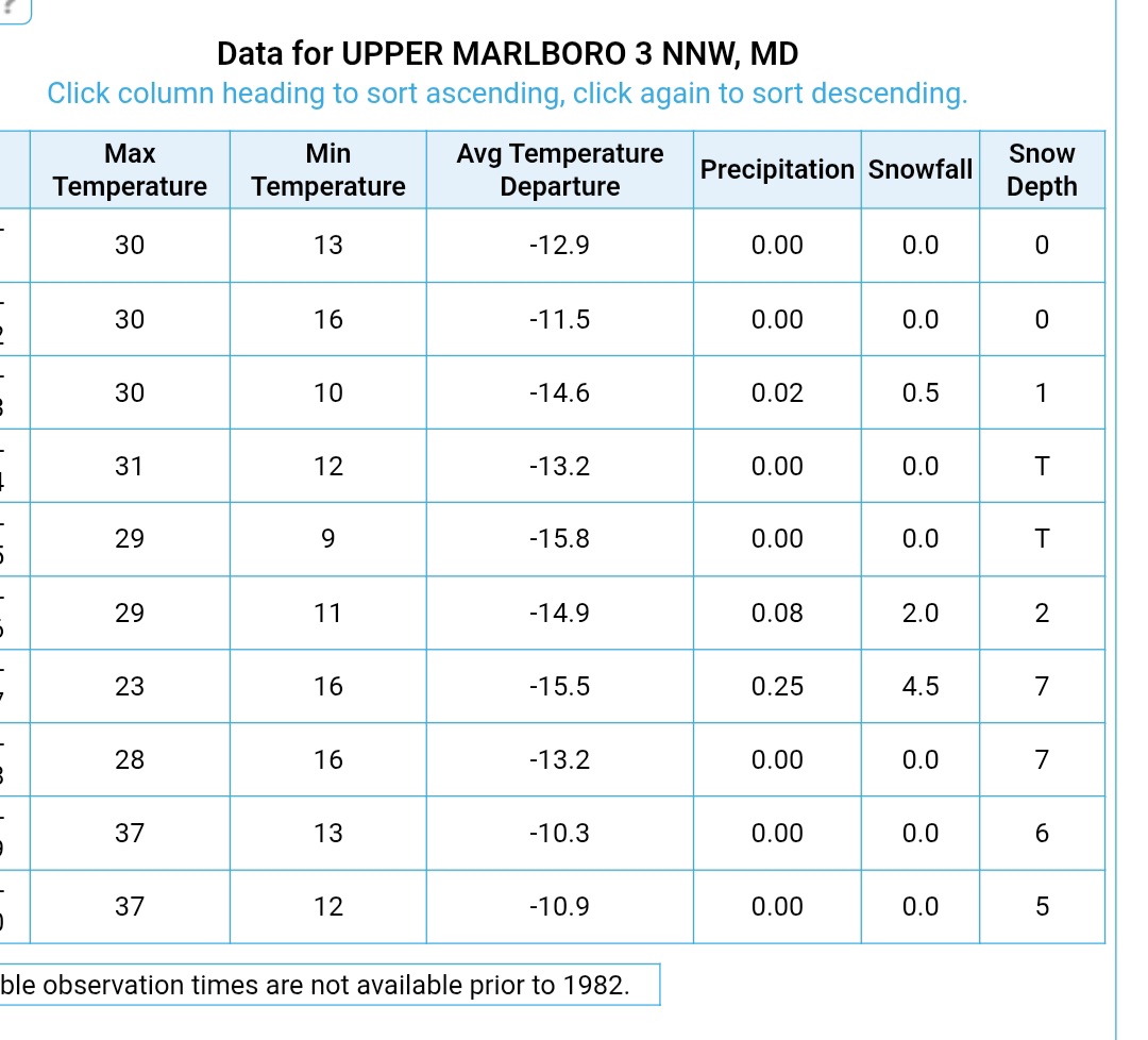
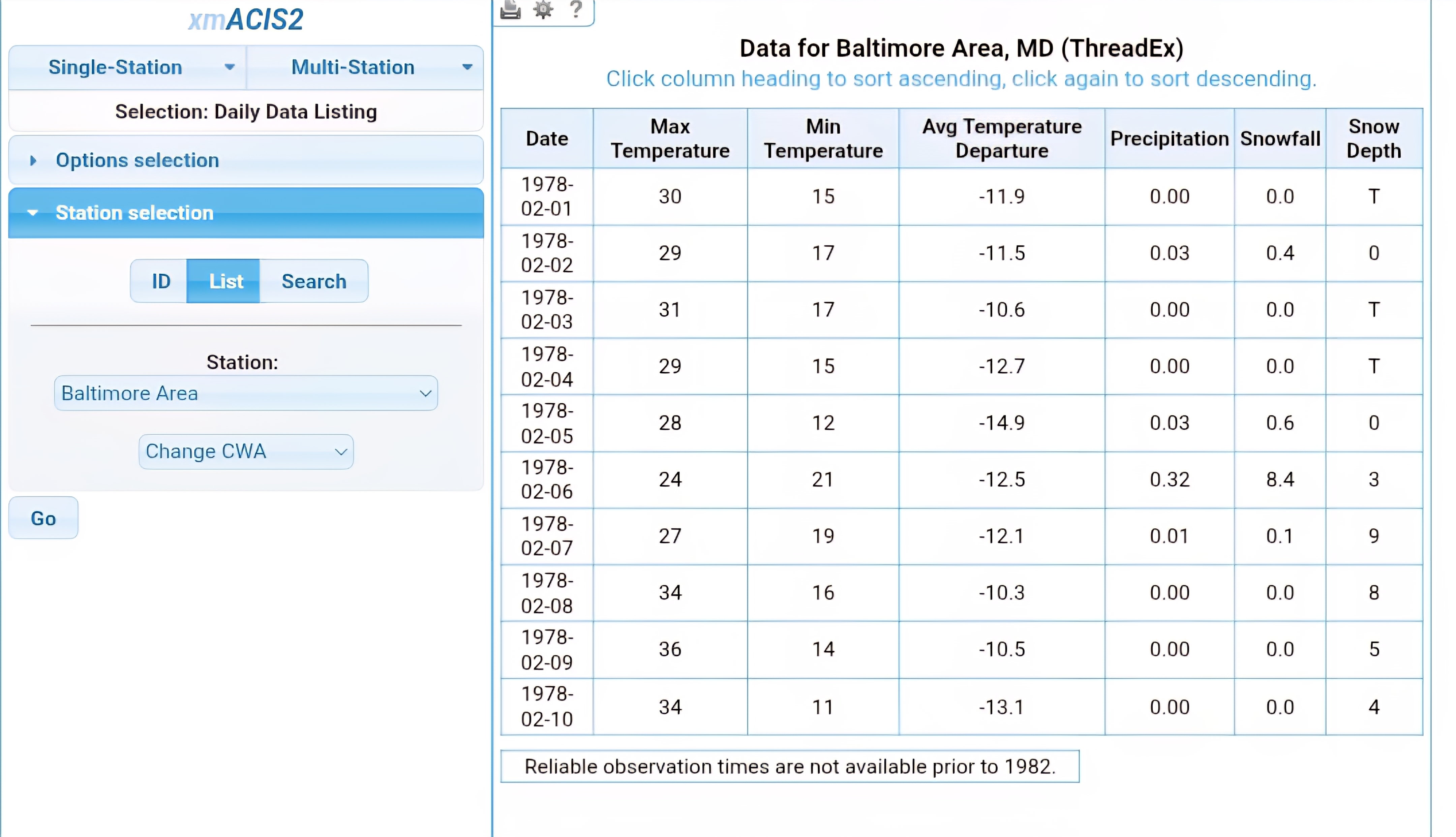
Hey, we have an interesting analog! Feb 6-7, 1978. Very similar in terms of track and rate of deepening with the low along the coast. Certainly a top 10 storm for BOS... perhaps this will be one as well. Interesting to see the snow totals around our area during the storm. DCA 2.2" BWI 9.1" 3 NNW Upper Marlboro 6.5" Certainly a colder storm, but we could very well see sharp discrepancies in snow totals W-E with our storm tomorrow into Monday morning.
-
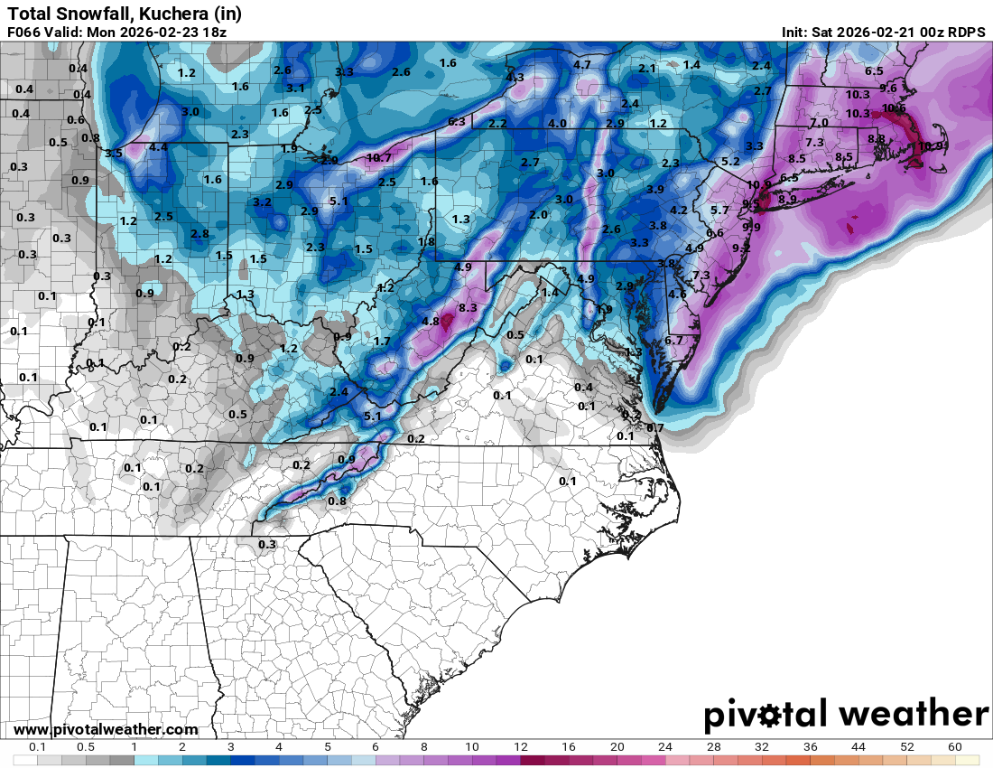
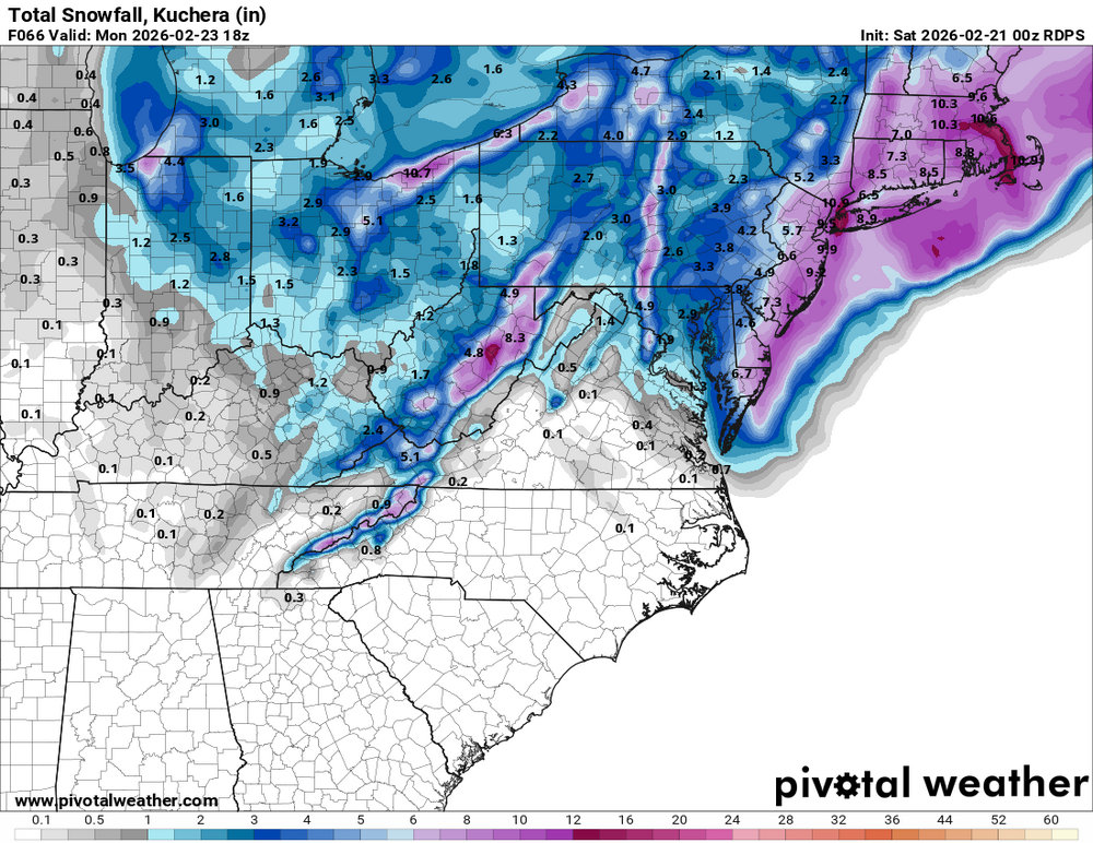
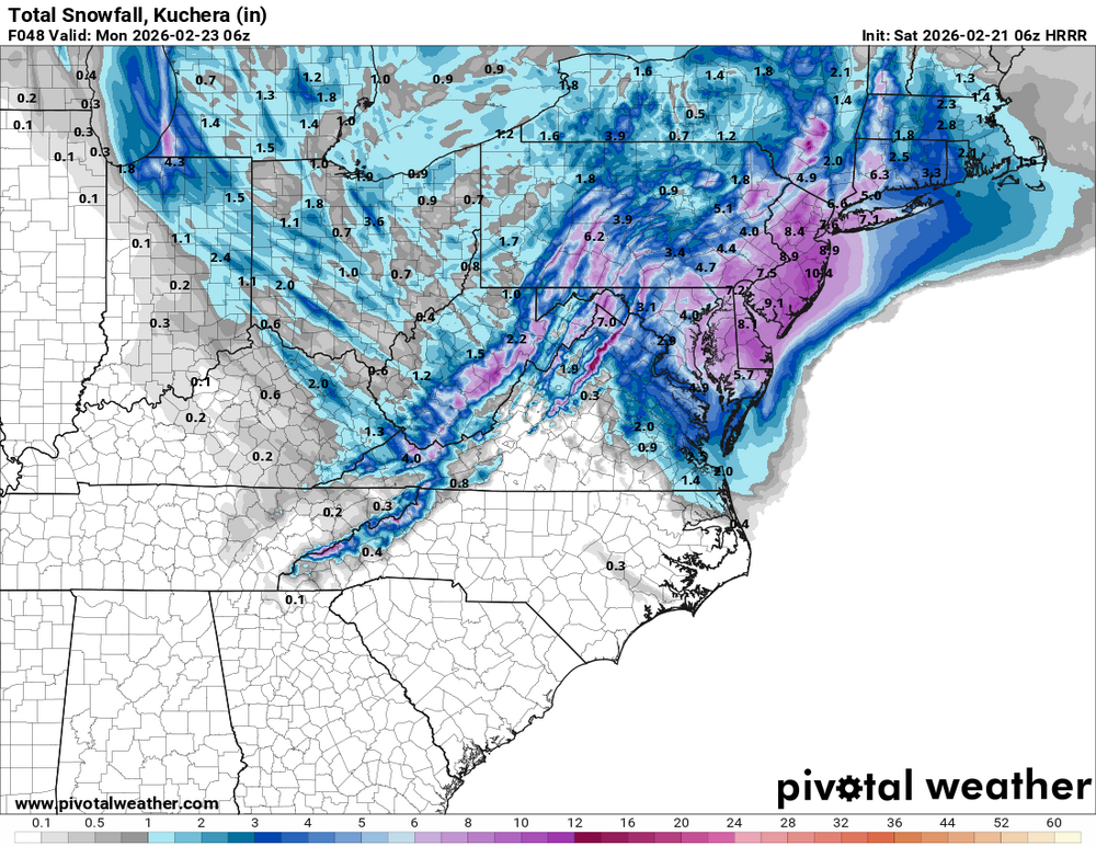
06Z RGEM Kuchera snow vs. 00Z totals. Still rather conservative (surface thermals) and mainly late afternoon into Sunday night. Areas in between the monster bands near the Atlantic Coast and the inverted trough band west could very well get sub-warning criteria snow given the weaker rates and marginal thermals.
.thumb.png.3e04d433c55d8847a539d177b4b62028.png)
-
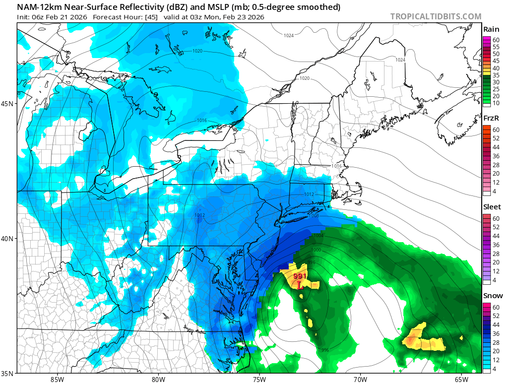
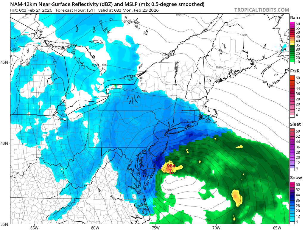
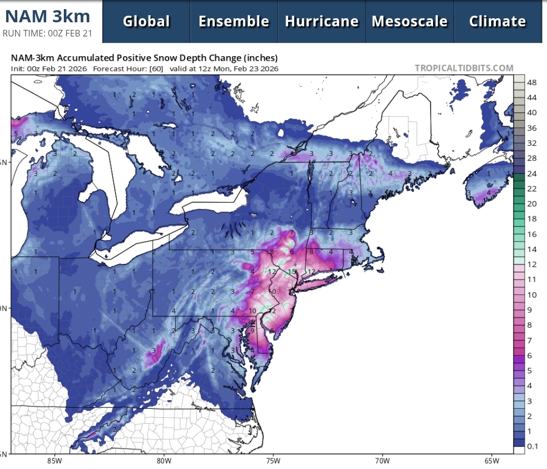
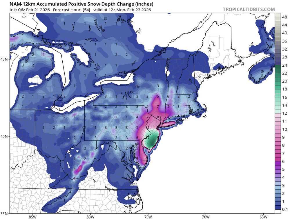
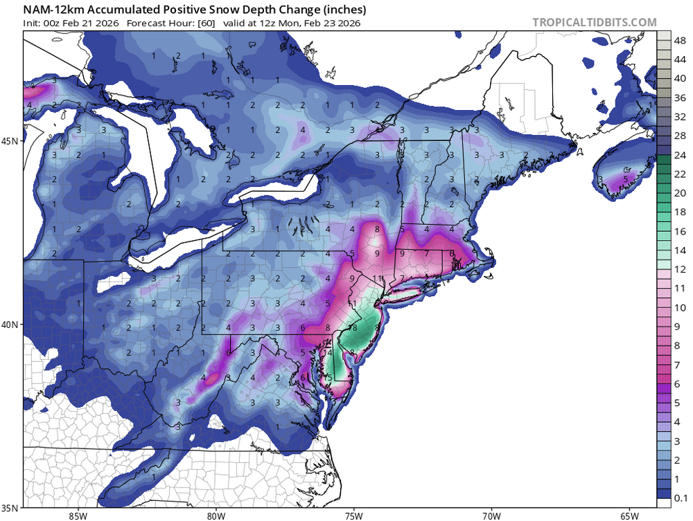
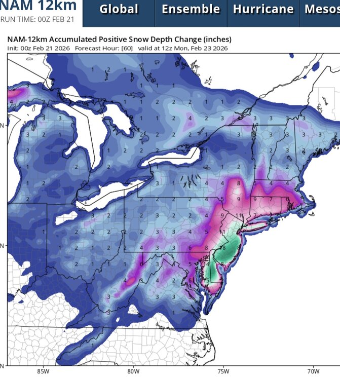
Yeah, from what I see through 12Z Mon from the 06Z NAM is that the positive snow depth change is MUCH lower than the 00Z NAM. Ruh roh folks. What did the EC and ECAIFS pick up at 00Z that the other guidance didn't? Something was captured upstream, because I fear we're seeing a trend.
-
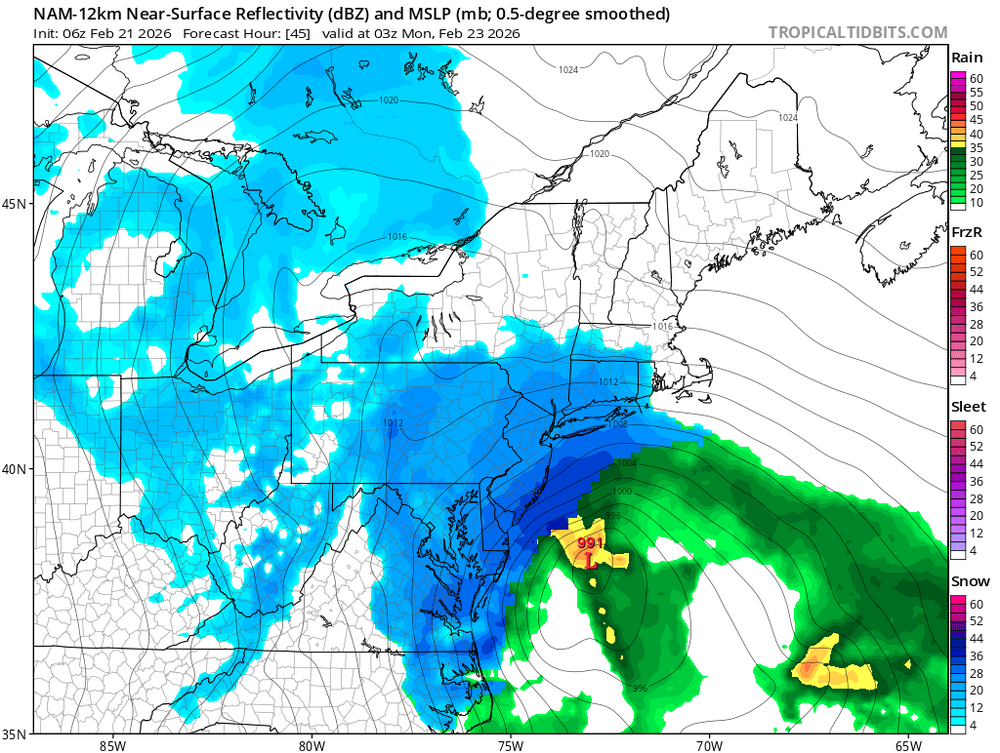
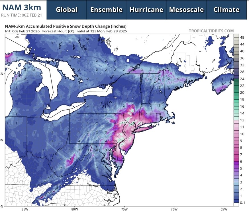
Yep, at least through 03Z Mon...
-
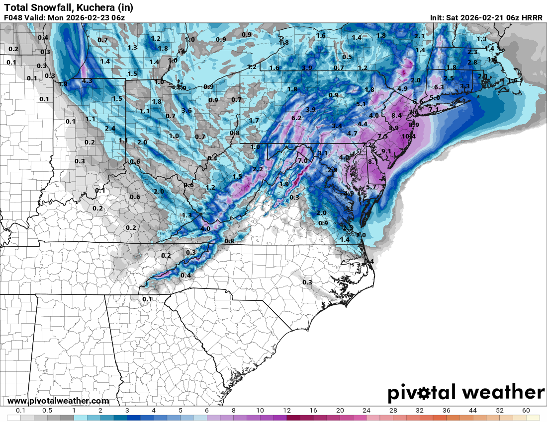
Ugh, just woke up after going down just before the GFS ran. Talk about swings. It's like watching a recorded game seeing your team up big at halftime, only to see it slipping away in the second half. Not jumping off the bandwagon yet, but gotta hope certain aspects of the ECMWF and AIFS aren't gonna become trends. That's is, um, where did the inverted trough go per the EC camp? That and a weaker surface low father offshore? It's like the EC runs of a couple days ago all over again. And I have to tell you, the CMC/GEM wasn't overly inspiring either, with the low farther offshore and much of our area in between the inverted trough band west and mega CCB band over the Eastern Shore. Lastly, the low over the VA Capes giving way to the new forming low off the NJ will need to be monitored. That can really screw with our totals. Remember a few winters back when Central Park had about 11" when they were supposed to get 2-3 feet (while areas east of them did)? That was the result of a similar quick transfer of energy. Not that 11" would be bad! But it was more than half less than what was anticipated. Damn this storm is littered with land mines. BTW 06Z HRRR Kuchera through 06Z Mon. Still snowing..
-
I will say though that those either within the Norlun trough band west of the Bay or over on the Eastern Shore closer to the low will likely see less disparity in projected Kutchera snowfall and positive snow depth change. That's all because of the rates. It really is gonna come down to that (...for the nth time mentioned, right?) Those areas likely closer to 8/9 or even 10-1 SLRs after 21Z Sun.
-
Just to throw some caution to the wind, which essentially becomes my low bar... NAM total snow depth change, considering the 33-34F surface temps, at least for most of us prior to 21-22Z. Note that both the NAM12 and NAM3 have the bulk of this after 21Z. The NAM3 particular, in my opinion, does a nice job with what looks like rain/snow mix until then, more rain or snow depending on the rates, again with the main show after 21Z. Again, what I would hope to be the absolute lowest bar. Even still, those east of the Bay still do quite well.
-
Hoping for the timing to be right. Ripping band will accumulate and bring down temps, even in the afternoon. Thus the widely used term "column cooling" because the entire sub-cloud column cools with the heavier rates. But again from a timing perspective, it would be great if that inverted trough/heavier rates would hold off until 20-22Z when we lose any solar effect. To play it safe IMBY (east of I95) I don't expect any accumulating snow until after 20Z. But when you look at the NAM, it snows all night. That's what we need!
-
Yep! I just remember holding at 32.5-33.0 with BIG dumping aggregate flakes! 11" or so for me in West Springfield VA, and even DCA did well. Less than 10-1 ratio certainly, so you'll want to look at Kuchera or cut the 10-1 by 20-30% to be safe. Hoping that the inverted trough banding would be mostly at night.
-
I actually lived in Japan as a youngster (age 9-13) when my Dad was assigned to Yokota Air Base. Went to a Boy Scout Jamboree in Zao, which I believe is north to northwest of Fukushima. Of course, that was in August. I recall it was quite beautiful! I hear Aomori, far northern Honshu, is the place to go for snow. Over 300" on average per year!
-
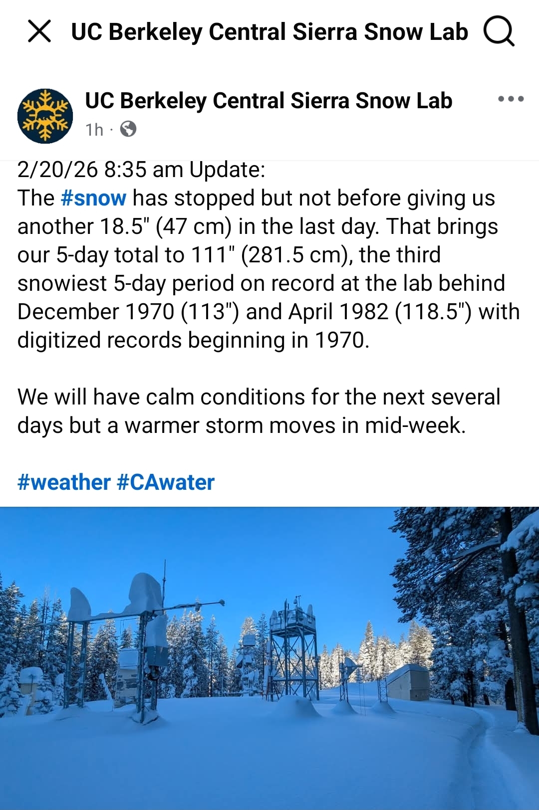
One of these days I want to experience this! I'm thinking Mammoth Lakes or Tahoe -- somewhere where there's some population and infrastructure. The guys at the Sierra Snow Lab in Soda Springs (west of Truckee) are in a pretty sparse location. Either way, You want to get your snow fixed, go to the Sierra. Or western/ northwestern Japan.

-
Feb 22nd/23rd "There's no way..." Storm Thread
WxMan1 replied to Maestrobjwa's topic in Mid Atlantic
When temperatures are marginal, it's all about the rates as you all know. Strong ULL and higher rates leads to more diabatic cooling from both melting and evaporation, in the absence of the cold, drier air funneling in isallobarically at low levels like we see in good CAD setups. We get the band set up, we get the rates with those clumping aggregates, then we can accumulate at 7, 8, maybe 9-1 SLRs with surface temps of 32.3-33.0. The whole column cooling to the freezing point. However, you don't get those rates then you just get a lighter rain snow mix, 33-34F. It will be that drastic of a difference. Good luck with that forecast! -
Feb 22nd/23rd "There's no way..." Storm Thread
WxMan1 replied to Maestrobjwa's topic in Mid Atlantic
Ah yes, that was the "Snowquester" of March 6, 2013. If you recall, sequester was in the news at that time, because of the lapse of government funding. At NCEP we use the term 'snowquester' because for us near the cities, We got nothing more than a rain snow mix because of the marginal temps. But this is important: We never got in on that backside CCB or deformation "death band" either. That's the key. That's what made 3/17 2014 (or 2015) so good for us along and east of I95. That and the fact that it fell at night. Waking up St Patrick's Day morning with 8.5" of snow on the ground was pretty sweet, and a great way to end a solid winter that year. Both 2013-14 and 2014-15 were good for us, well above climo. -
Feb 22nd/23rd "There's no way..." Storm Thread
WxMan1 replied to Maestrobjwa's topic in Mid Atlantic
Yeah, it's all about the backside cold conveyor belt (CBB) and deepening Trowal zone, and for us near/within the beltways, I think we're gonna want much of that action after 22Z. Rain or just white rain before that. Interesting, I keep seeing IVT tossed around (integrated water vapor transport). Usually a term used with ARs (Atmospheric Rivers), but we certainly to see these plumes here in the East. Analogous to a PW axis, theta -e axis, TROWAL, -- merely another tool to show that there's good moisture pooling/isentropic ascent upstairs. Our snow here in the cities will be completely tied to that CCB/Trowal/IVT or backside deformation axis. Any QPF before that is dead to me, but perhaps not to folks well N and W of the fall line. Setting my bar here in central AA pretty low for now, 2-4" with the wrap around and heavier rates. -
Feb 22nd/23rd "There's no way..." Storm Thread
WxMan1 replied to Maestrobjwa's topic in Mid Atlantic
Might be more like a 6.5/7/8 to 1 ratio when all is said and done, since some of that may be rain or white rain at the onset, and the other heavy aggregate flakes at 32.3-33.0F. And if I'm being honest, I wish the bulk of the event were at night and not during the day. Who remembers the St Patrick's Day snow in 2014? We got like 8.5" in Crofton that night (going into the 17th). At that event fallen during the day, we probably would have gotten half that amount. -
Feb 22nd/23rd "There's no way..." Storm Thread
WxMan1 replied to Maestrobjwa's topic in Mid Atlantic
Agreed. I also think most of the accumulation would come after 22Z anyway, when sun angle won't be as much of a factor, coinciding with that backside deformation/CCB. That 22-12Z timeframe is when we can cash in the most, not coincidentally, when the sun is down. I'll see you tomorrow morning at work! -
Feb 22nd/23rd "There's no way..." Storm Thread
WxMan1 replied to Maestrobjwa's topic in Mid Atlantic
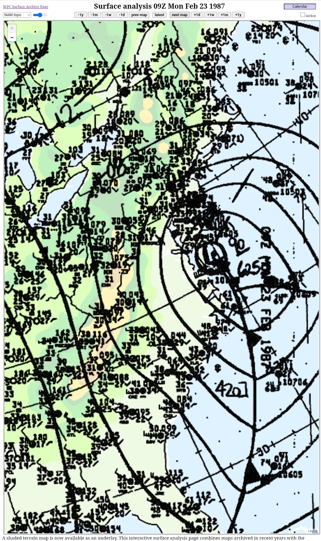
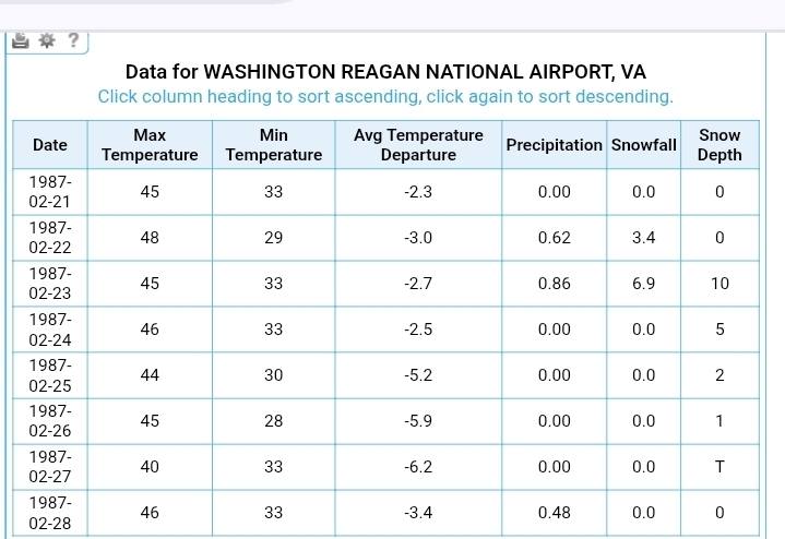
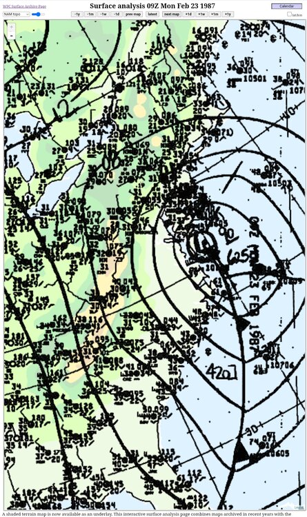
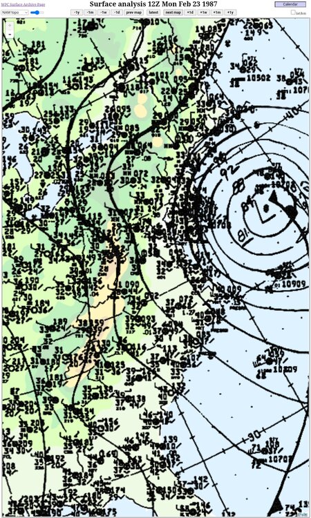
As y'all have noted, it will all come down to the rates. While not quite the same sfc low track (at least what's being forecasted), the Sun night-Mon morning snow Feb 22-23 1987 was one that I remember where rates overcame surface temps around 33 during the storm in the metros. The high was actually a balmy 48F at DCA 7 or so hours before the snow started. Areas north and east were able to cash in much better in this event because of their thermals. I believe this event gave parts of southern PA over 20". Low was more tucked towards the VA Capes initially.


-
Feb 22nd/23rd "There's no way..." Storm Thread
WxMan1 replied to Maestrobjwa's topic in Mid Atlantic
The only F word I want to hear within the next 1/2 hour or so is FOLKS! -
Feb 22nd/23rd "There's no way..." Storm Thread
WxMan1 replied to Maestrobjwa's topic in Mid Atlantic
Again though, it's parallel version has been different, more like the other camps. @high riskwas right, the 06Z version did have a weaker low farther offshore, but I believe it was the 00Z 2/19 run of the GFS para that didn't have much of anything. So even this model might be trending towards the more amped members; I am not at work now so I'm not privy to the latest parallel GFS. But it does seem, at least to me anyway, to be a significant upgrade. Unfortunately, that means we'll have to do this all over again (verification and bias adjustment) next winter as the old GFS makes way for the new v17. It'll be okay not to trust it, but it won't likely be this far off course. Then again, I'm not a modeler so.. -
Feb 22nd/23rd "There's no way..." Storm Thread
WxMan1 replied to Maestrobjwa's topic in Mid Atlantic
Sorry if already posted, but I heard from a coworker that the new parallel version of the GFS (v17) didn't even have a low last night! Are we gonna go from one extreme to another with this model? -
The Jan 31 Potential: Stormtracker Failure or 'Tracker Trouncing
WxMan1 replied to stormtracker's topic in Mid Atlantic
This is an excellent opportunity to consider the 'self-development process'. True, the upper levels (amplification) dictate what goes on at lower levels. Cyclogenesis, frontogenesis, etc. However whenever you can get an overabundance of sensible and diabatic heating into the system (i.e. over the Atlantic Gulf Stream), you can actually get the low-level dynamics to reform what happens aloft. In other words, accelerated amplification in the upper trough that isn't solely from exit region upper forcing upstream (i.e. DPVA). It's all about what the Atlantic can do for us. The Gulf Stream as well as those shelf waters. This would be a good time actually for positive SST anomalies..png.02d4ec55758c89a5b6ebae2032265a28.png)
-
Not to mention the cooling affect (diabatic cooling) whenever there is any melting. Guaranteed with 4-8+ inches of snow, depending on your location, along with a thick layer of glaciating sleet, many areas east of I-95 expected to flirt with 30-32F per the guidance won't unless we get a substantial E-SE surface wind.
.png.e4e4d89d4ddbd063168f0d5f06e5089b.png)


.png.64150311c1c660a23619ba2a75e186ec.png)