WxMan1
-
Posts
809 -
Joined
-
Last visited
Content Type
Profiles
Blogs
Forums
American Weather
Media Demo
Store
Gallery
Everything posted by WxMan1
-
I was noting earlier that the low track this go around is more of a hybrid Miller A/B, so at least this time we shouldn't have to worry (as much) about transfer issues or a rapidly impinging dry slot. Hoping this time we'll see a prolonged period of fatty flakes before the flip. While during the prolonged snow/sleet/freezing rain/back to snow event the other week I ended up with 4.0" of storm total snow, for the winter thus far I still have yet to see more than 2.5" before ending or mixing. So 3-4" is my bar. If we can get more than that from DC and areas along 50 east to the Cape, and add on a little glaciation with some sleet and freezing rain, I'll be happy.
-
Well, in terms of storm type, it's probably closer to a hybrid Miller A than a B, at least with respect to the surface reflection. Doesn't look like we'd have the transfer issues a B-type storm would have (and has given us) this year...so I can certainly see why the guidance trends would be more bullish in terms of the upper-bound or "boom" totals. I do see enough pieces of guidance (including the 18Z para GFS) that shows that "claw" configuration some of you were referring to (later changeover = heavier snow N/NW of DC, better initial FGEN/QPF and front-end thump = heaver snow S/SE of DC) -- which would leave the 50 corridor from DC to Annapolis (MBY) in a relative min. Still -- I have yet to experience a snowfall this year that yielded more than 2.5" before dry slotting or changing to sleet or freezing rain. So, my bar is 4-6", which I would most assuredly take along with any glaciation of sleet and freezing rain that follows.
-

Feb Long Range Discussion (Day 3 and beyond) - MERGED
WxMan1 replied to WinterWxLuvr's topic in Mid Atlantic
Preface -- this is NOT a criticism or meant to be banter... When would we normally start a storm thread for Feb 18th? Would we wait until this upcoming (Tuesday) system is done? -
Well, better late than never for us here in AA. 28/25 with sleet and freezing rain here in Crofton. Big ? will be how much accretion from FZDZ do we see tonight after the precip shuts off?
-
As many of us hinted last night... Not a surprise at all. We have so many events, including the 3/16" of ice here with the last event after 2.5" of snow, where we get a glaze that sneaks up on us. There were far more glaring model signals going into this event however, including a steadfast ECMWF, that were screaming ISW.
-
Freezing rain here in Crofton, 28°/23°. As I mentioned yesterday, the forecast *still* has us getting to 37°F tomorrow. With no horizontal temperature advection and a bolstered in-situ CAD setup with all that sleet and ice to melt (diabatic cooling), I have no idea when we'll hit the freezing mark again. Monday perhaps?
-
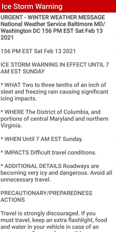
We have a thread titled February 13, 2021 Ice Storm. I would be stoked if our FZRA or FDDZ threat didn't extend into Sunday or even Monday, at least for some areas away from the cities.
-
With apologies to sounding banter-ish... Current temp forecast for the greater beltway region have temperatures climbing above freezing Sunday into Sunday night and Monday. With all the potential sleet and ice laying around, along with the lack of any advection whatsoever at the surface, and all of that latent cooling due to melting of ice... how on Earth are temperatures going to get above freezing during this time, at least for many areas away from the city? In-situ CAD is a real thing; we've observed it on countless occasions, and yet the guidance (once again) suggests surface temperatures will climb above freezing sooner than later. Falling for that scenario would be like believing that Lucy will not pull the football away this time around when Charlie Brown tries to kick it. Someone take me off the ledge at convince me that the Sunday night to Monday wave isn't additional light freezing rain or drizzle.
-
Nice aggregate flakes here in Crofton, 34F.
-
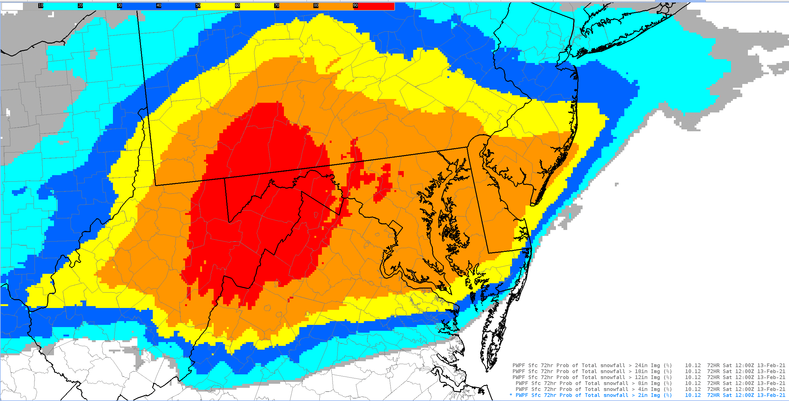
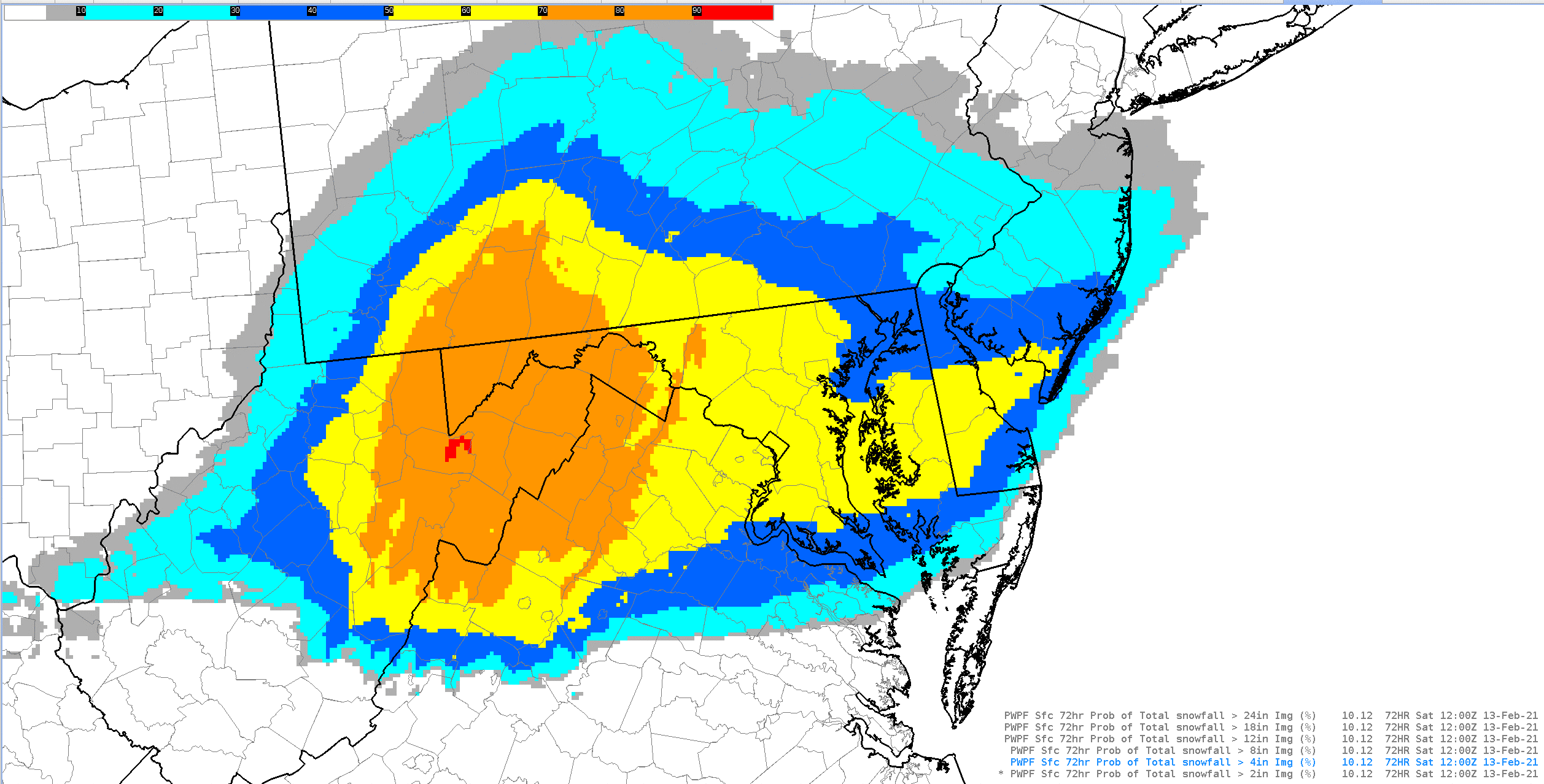
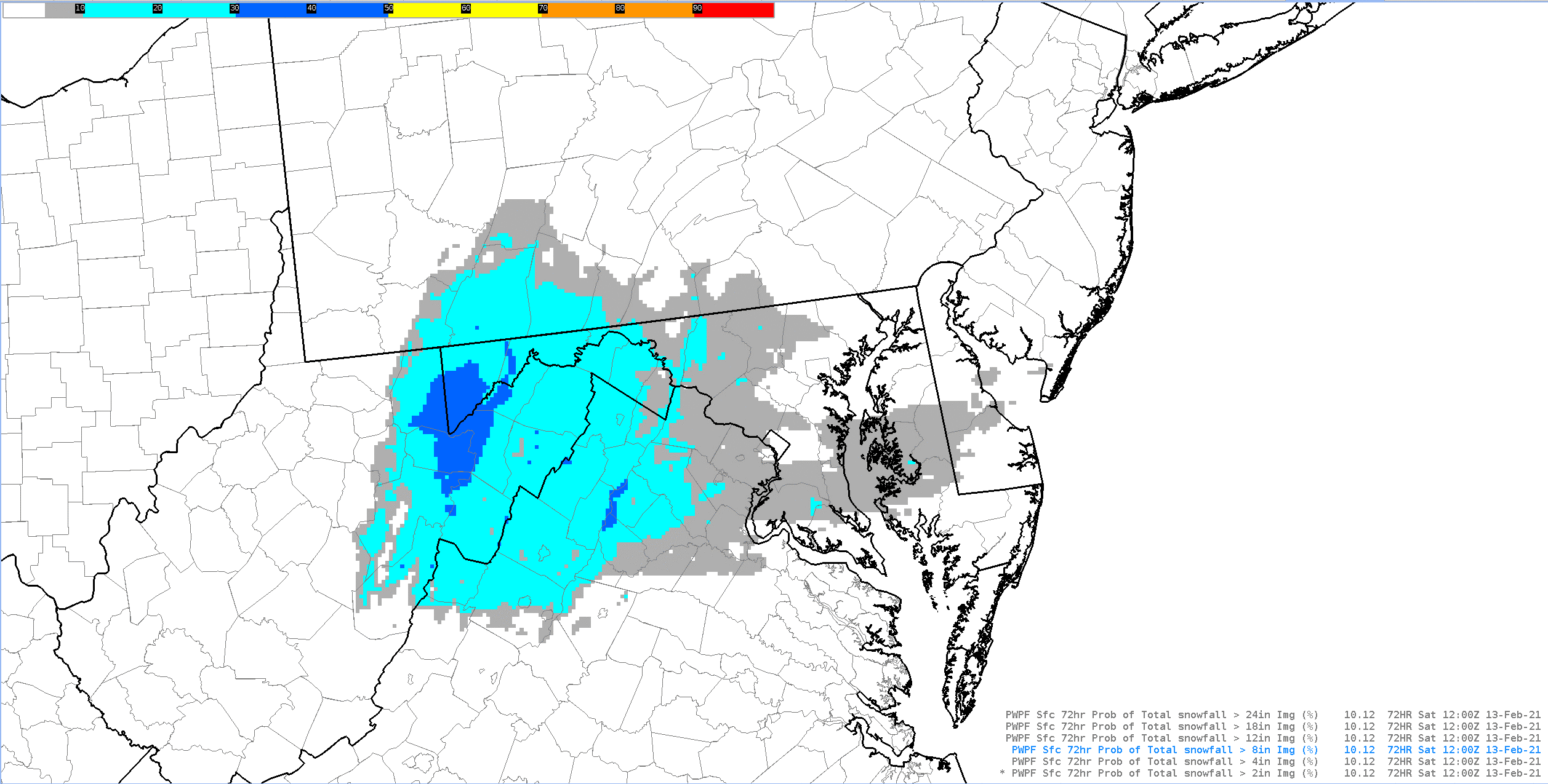
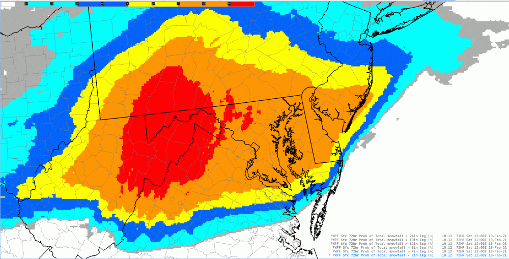
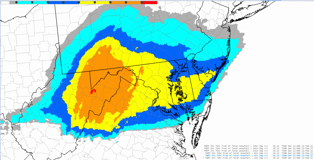
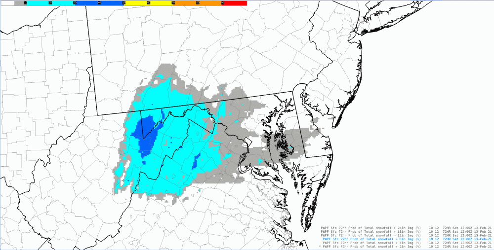
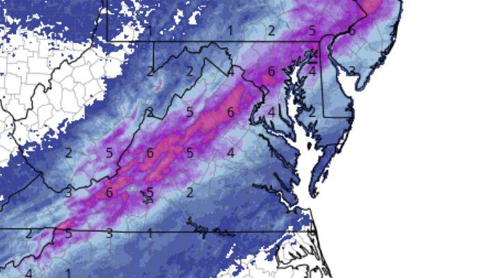
00Z ECMWF, like others, are clustering along the 50 corridor for us easterners along/east of the District. Anyway, hot off the presses: The latest 72hr probabilities from WPC (2", 4", and 8"), along with the 50/50 or "most likely" amount. Guidance is really clustering in on a 3-5/4-6" type scenario for most of us with both waves (still feel the bulk for most of us along/north of U.S. 50 will see the bulk in wave #1). Notice how the probs of >2" and >4" in the 3-day period are pretty high, then drop precipitously with the >8" probs -- indicative of a moderate event with probably "meh" rates over (hopefully) a longer duration, as lift in the DGZ remains lackluster.
-
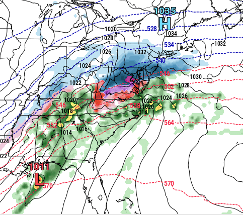
TT https://www.tropicaltidbits.com/analysis/models/?model=gem®ion=neus&pkg=mslp_pcpn_frzn&runtime=2021021000&fh=60
-
Yeah, I meant to say 2013, my bad! All snow now in Crofton, 34F. Big, aggregate, clumping flakes. At least not the wet mangled variety we had earlier. Diabatic cooling effects due to both evaporation and melting happening right in front of our eyes. So very cool to observe.
-
Still a snow and rain mix here in Crofton, 35°F. Evoking lots of memories of Snowquester here (March 6, 2012). Without the cold antecedent airmass, those that will do well (better) are our friends over higher elevations and/or under FGEN, perhaps convective banding. Otherwise, meh.
-
39/21 in Crofton. Outside of the dewpoints (which are lower), this antecedent airmass feels very March-like, especially with high around 50F Sunday. I was getting PTSD vibes right before "Snowquester", or the March 6, 2013 event, but then realized that our dewpoints (and thus wet bulbs) are lower. Of course, that was a much bigger system, Miller B, with the transfer and lack of FGEN over the DC-Balt corridor really hampering our rates and (thus) accums.
-
This is something to watch. There's definitely a March-ish look to this system. Some potential instability aloft, real good 850-700 FGEN as well. Translation: Good chance for banding. Usually the northern (heavier snow) axis is where there's better/deeper lift in the DGZ, while the southern axis aligns with some lower FGEN along with some better elevated instability potential. So what happens "in between", which would be the immediate DC metro as implied from the current UKMet and GFS? Just like any other weather scenario where there's weak symmetric stability or some (weak) instability: areas in between bands will see relative subsidence in layers (weaker UVVs overall), which kills the rates. When your boundary layer temps are marginal (33/31 at the surface for example), rates are EVERYTHING.
-
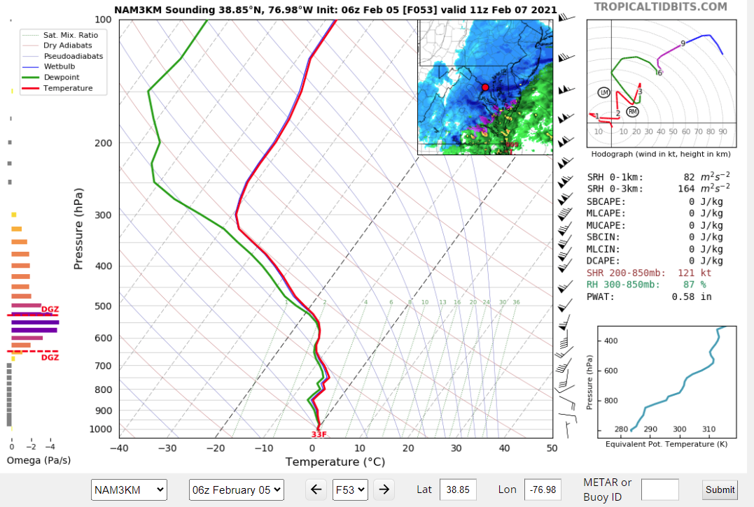
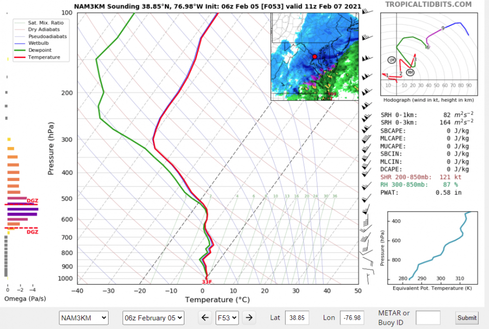
NAM Nest = NAM CONUS-Nested version, or 3km. It's the NAM's CAM.
-
11Z Sunday over the District per the 06Z 3km NAM. Nice lift in the DGZ. If it comes to fruition, we would see MUCH better dendrites than we saw last Sunday. Thus much better (faster) accumulation efficiency. Like 4+ inches within 12 hours instead of having to wait 24-36 hours (lol).
-
06Z NAM Nest for Sat night-Sunday. Definitely juicy. This is with the Ferrier rime correction (capped at 10-1). If it's all snow w/o rimed flakes and a >10-1 SLR, we would get more. The NAM Nest Ferrier snow maps did a pretty good job in the DC area for the WAA phase in the last event (on Sunday).
-
Jan 31st - 33rd Storm Obs and Disco like it's 1979
WxMan1 replied to Bob Chill's topic in Mid Atlantic
Good size aggregate flakes here in Crofton (AA County), though I fear such is a prelude to a mix coming soon from the SW (which the CC would imply). -
Jan 31st - 33rd Storm Obs and Disco like it's 1979
WxMan1 replied to Bob Chill's topic in Mid Atlantic
1.5" here in Crofton, north-central AA County, as of 1 pm. Lots of pixie dust snow today. I see the stronger echoes approaching from the south, but how much of that will be additional accumulating snow before the mix? I was thinking about the Miller B type storms around here. I did a study about the Miller type storm classification, with a reanalysis of several systems since 2008. Every one is different, even if a little, as we know. Most are not handled very well by NWP, at least in terms of trying to get it consensus at T-36 or 48 hours. We know that as well. Most are scree jobs for us, another known fact. But I then started to think, what was is about all those Miller Bs in 2013-14 and 2014-15 that did reasonably well for us here along 95 into the eastern burbs? What was different? Antecedent Arctic air, *that's* what's missing. When you have that colder dome going in, WAA is much more effective (greater slope of the theta surfaces, i.e. better rise/run), as your dendritic growth zone layer (-12 to -18C temps) is lower in the troposphere. Better chances of getting moisture and lift in the DGZ when you have a colder airmass in place. Heck, I vividly recal a system that gave us 4-6" region-wide with the surface high moving out to sea off the Mid-Atlantic coast! Straight, deep layer southerly flow, but the fact that the antecedent airmass was arctic cold to begin with gave us a ton of WAA snow potential before dry slotting or any mixing. While not like the Snowquester March 6, 2013 disaster, which had neither the antecedent cold air nor decent deep layer lift over our region (given the timing and location of the low transfer to the coast), at least right now, this to me feels like another in a long line of under-achieving Miller Bs for the majority of our area. Which I guess would come as no surprise. But the fact that the NWP still struggles with the details here in the 3rd decade of the 21st century, maybe that's what most disillusions me. -
Jan 31st - 33rd Storm Obs and Disco like it's 1979
WxMan1 replied to Bob Chill's topic in Mid Atlantic
Well, we're taking a bit of a beating on the trends tonight. Notwithstanding the GFS (which I cannot envision it trending for the better), it appears that a lot of the newer guidance, particularly the CAMs, are not as bullish beyond 00Z Monday. I would gladly take this ICON prog off of WB...if it were "deal or no deal" I'd be slamming my hand on that button so fast you wouldn't even see it. The problem is -- how much accumulation is progged after the changeover tomorrow evening? At this point, those of us in and around the beltway really cannot rely on additional accums Monday. Ergo, a high-end advisory for most (3-5" in 12 hours). Gosh I hope I'm wrong, but these trends are disturbing, though not never before seen with a Miller B. -
I get the nervousness about the CCB given the model trends, and the long history of Miller Bs in our region. As many of you are saying, at least there's solid consensus of 3-5, maybe 3-6" of WAA snow before the changeover to light sleet or dry slot FZDZ. But I also remember the 2nd phase (day 2) of 3-5" during our last significant winter storm (January 2019). We were all "pleasantly surprised" to be getting some CCB love. But should any additional snow on Monday come as a surprise when some pieces of guidance (GEM and EC) continue to show some CCB love down this way? Especially the EC, which led the way with this event to begin with in the medium range? Still optimistic that we can get more than just marginal warning event snows, at least here in the eastern burbs/BWI region. But as always, will take what we get, especially this winter.
-
When I lived in Chesterfield County (while working at AKQ), quite often the 6+ inch snowstorms required some CCB/backside frontogenetic action. Lots of events with 1-2/2-4" front side WAA and that's it before the dry slot and eventual wrap around staying north. We did get a nice front-end thump however on Dec 18, 2009 before switching to sleet then rain. More recently, the Jan 23, 2016 event in Central VA was "made" by the CCB on day 2. The Dec 9, 2018 event was a central VA classic, wdsprd 10-12", with a flatter (and yet still elongated) CCB allowing for the duration that is needed to produce these high amounts. To me, what happens Sunday night and Monday will dictate whether or not the event for the RVA ends up being more an advisory/low-end warning one or something much more significant.
-
I guess this would qualify as banter.. Who else was alive and remembers the Challenger explosion 35 years ago today? I was 15, living in Springfield VA. Aside from the trajedy that day, another indelible memory for me was a Nor'easter that was to never be that weekend for us in the mid Atlantic. Cold and dry, with any development well off the coast. Not sure which model was pummeling our area with heavy snow... NBM perhaps? Imagine if thiis forum was around 30-40 years ago with the state of NWP back then? Lots of broken hearts for sure!
-
I did a bit of research on the topic a few years back. It was quite an illuminating experience! Miller_Cyclogenesis_Classification_US_Atlantic_Coastal_Region.pdf