Poimen
-
Posts
2,150 -
Joined
-
Last visited
Content Type
Profiles
Blogs
Forums
American Weather
Media Demo
Store
Gallery
Everything posted by Poimen
-

The December to Remember 7th-8th blue turd winter threat thread.
Poimen replied to lilj4425's topic in Southeastern States
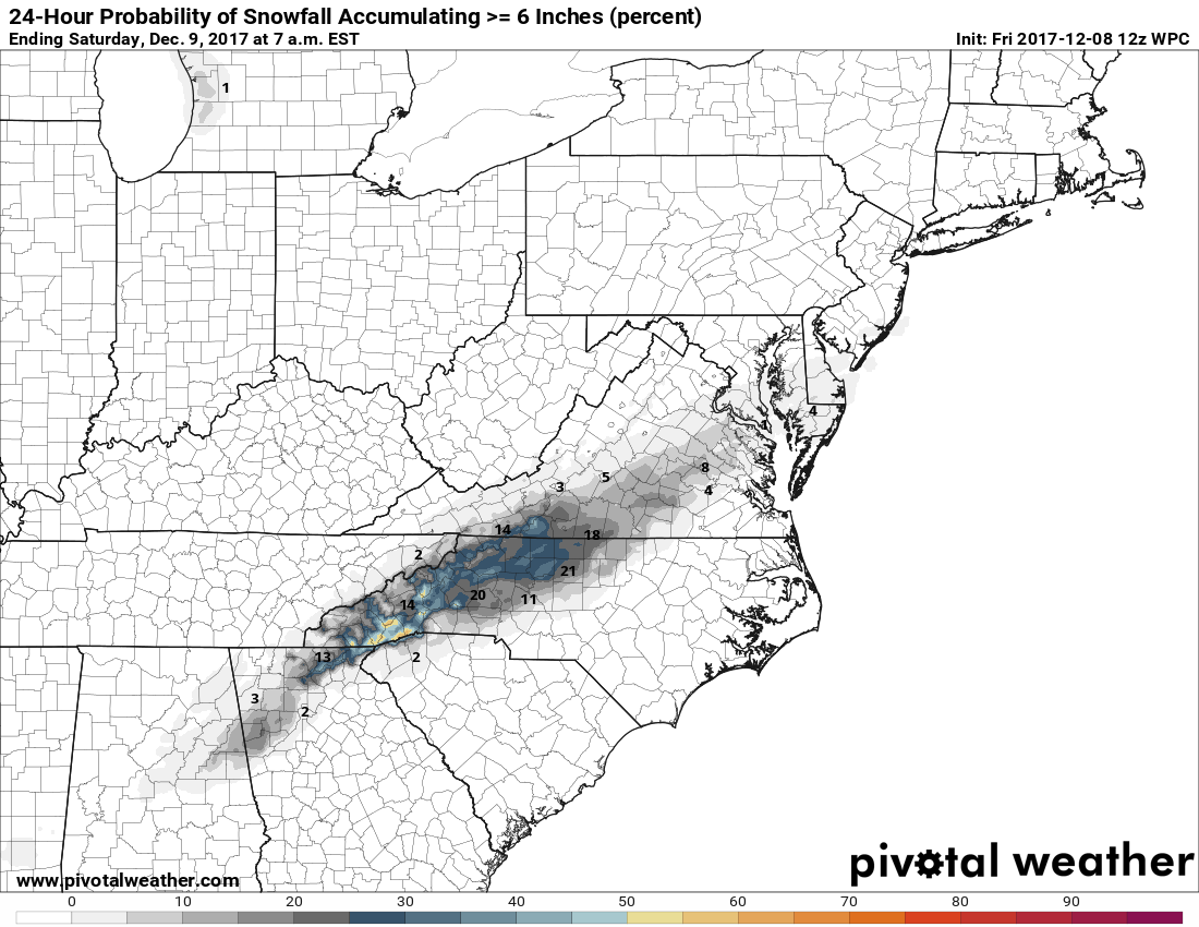
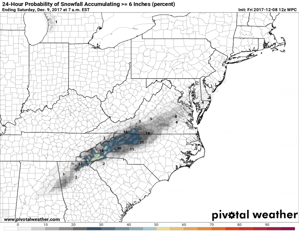
Latest 1" and 6" snowfall probabilities through 7am Saturday.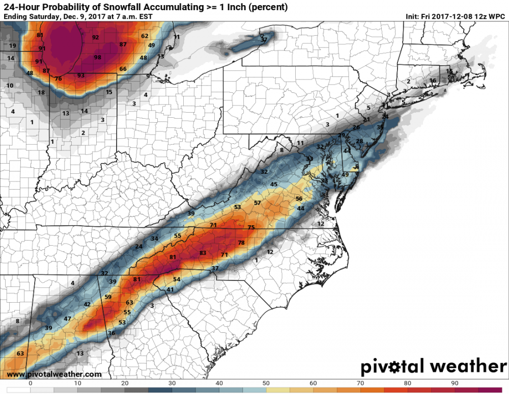
-
The December to Remember 7th-8th blue turd winter threat thread.
Poimen replied to lilj4425's topic in Southeastern States
Welcome to the south, my friend! -
The December to Remember 7th-8th blue turd winter threat thread.
Poimen replied to lilj4425's topic in Southeastern States
Some of you are going to like the 0Z RGEM. -
The December to Remember 7th-8th blue turd winter threat thread.
Poimen replied to lilj4425's topic in Southeastern States
Where have I seen this before? lol -
The December to Remember 7th-8th blue turd winter threat thread.
Poimen replied to lilj4425's topic in Southeastern States
The 18Z GFS showed rain tomorrow with an expanding precip shield to the NW, then gradually changing to snow from west to east overnight and Saturday. That's probably the best scenario at this point. I wouldn't expect much in the way of snow tomorrow in NC outside of the mountains. -
The December to Remember 7th-8th blue turd winter threat thread.
Poimen replied to lilj4425's topic in Southeastern States
I think the 18Z GFS is much more realistic, showing an expanding rain shield to the NW tomorrow (snow in the mountains), then changing to snow from west to east across the foothills and northern Piedmont as the entire system shifts east Saturday morning. -
The December to Remember 7th-8th blue turd winter threat thread.
Poimen replied to lilj4425's topic in Southeastern States
Thanks, Grit! -
The December to Remember 7th-8th blue turd winter threat thread.
Poimen replied to lilj4425's topic in Southeastern States
Agreed completely. One question about the EURO: Does it extend the precip into Saturday? -
The December to Remember 7th-8th blue turd winter threat thread.
Poimen replied to lilj4425's topic in Southeastern States
Yeah--let's remember that more often than not, even in January, those snowfall maps end up being reduced by at least half, if not more. As others have said, I'd be shocked if anyone receives more than a car topper this time around. But be of good cheer, winter seems to be setting in for the foreseeable future. -
Forgive me if this is addressed elsewhere, but can someone explain the difference between the NSIDC numbers and Wipneus' numbers posted on the Arctic Sea Ice forums? According to his figures, extent and area have only declined since the 25th. Why is there such a discrepancy?
-
Like I said, we'll see what happens. Given the UK/CM are both north of the GFS lends credence to the NW trend theory. Time will tell.
-
I knew we were dealing with suppression in the EC when I woke up and checked the weather app on the iPhone.
-
It seems as if the post-Christmas blues have arrived in full force...
-
That's my b-day. Would be a great gift, but I'm not holding my breath.