
Poimen
-
Posts
2,150 -
Joined
-
Last visited
Content Type
Profiles
Blogs
Forums
American Weather
Media Demo
Store
Gallery
Everything posted by Poimen
-
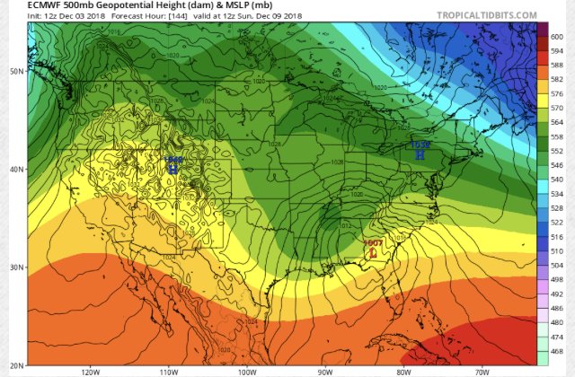
Yeah...1039 high is a bit stronger than previous runs. Let's see where she goes from here.
-
I’m always leary of questioning Dr. No, but is this a classic case of the model underestimating the depth of cold/CAD airmass at this range, or is that just my inner weenie talking?
-
If I had to guess, I’d say this setup produces significant snow for large portions of NC 9 times out of 10.
-
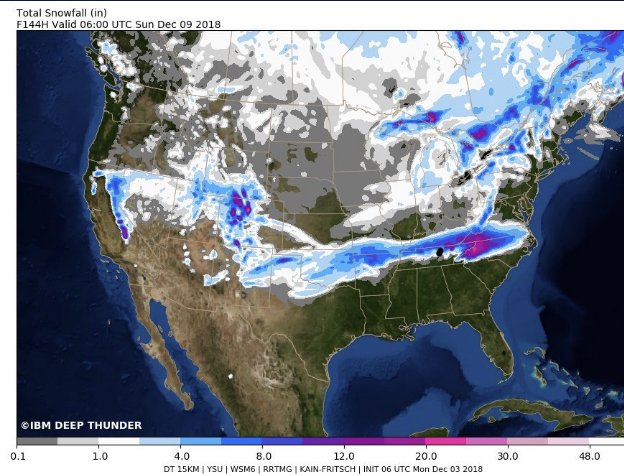
Deep Thunder is on board:
-
Just to clarify: we are now about 120 hours from the front end of the storm...so we are getting pretty close to having a good handle on that part of the storm at least.
-
Yeah...me thinks the old GFS is just playing to its old bias of being too suppressed at this range. The FV3 is a beaut, Clark, with snow arriving in WRN NC mid-day Saturday.
-
Looks like the 6Z FV3 is going to be another winner for many of us. Edit: it snows on the FV3 across much of the upstate and a good deal of NC from mid-day Saturday through late Sunday night. The clown map should be fun.
-
Man...I don't recall ever reading such LR confidence in a RAH discussion as I just read (in regards to a potential winter storm). Reading between the lines, the forecaster seemed bullish. On to the 12Z suite. In-short: A winter storm is expected to impact portions of central NC next weekend. While uncertainty on specific local impacts remains highly dependent on overall track, strength, and arrival time of said system, confidence continues to grow that some sort of wintry mix will occur across the northwestern piedmont of NC. Now is the time to triple check your winter weather supplies and emergency kits, and continue to check back in on the forecast for further updates.
-
y'all have fun staying up for the EURO. I'll catch the update in the a.m. Good luck and good night!
-
Raging rain storm on the GFS for pretty much all of NC. ICON/GGEM similar as well.
-
0Z ICON looked similar, FWIW.
-
Not really. Two totally different scenarios.
-
Yeah, it’s a little early for “congrats” or “woe is me.” Suppression is pretty much a good sign for most of this sub forum. Relax and enjoy the ride this week. At the very least, some of us might see the first flakes of the season, and if we’re lucky some might see much more.
-
12Z GGEM has the center between Lookout and HAT at 12Z Friday...FWIW.
-
As a life-long Outer Banker (until recently), my experience plus the current modeling suggests to me that a landfall closer to Cape Lookout seems more reasonable at the moment. That's just my 2 pennies.
-
Dollars to donuts says the EURU completely caves this afternoon.
-
We can't even buy a flippin' clipper. When was the last time a clipper even produced anything east of the mountains? Anyone remember?
-
What's the over/under on the next SREF mean for RDU? BY the way...pulling for you guys in the Triangle.
-

The December to Remember 7th-8th blue turd winter threat thread.
Poimen replied to lilj4425's topic in Southeastern States
RAH is fairly bullish with the next round--1-2 and possibly 3" amounts in the Triad. -
The December to Remember 7th-8th blue turd winter threat thread.
Poimen replied to lilj4425's topic in Southeastern States
using the Kuchera method, the 18Z NAM drops 6" in eastern Forsyth county. We'll see. -
The December to Remember 7th-8th blue turd winter threat thread.
Poimen replied to lilj4425's topic in Southeastern States
We have a dusting in Kernersville. -
The December to Remember 7th-8th blue turd winter threat thread.
Poimen replied to lilj4425's topic in Southeastern States
Interesting. The soundings all looked good to me. But hey--I'll gladly take whatever at this point. -
The December to Remember 7th-8th blue turd winter threat thread.
Poimen replied to lilj4425's topic in Southeastern States
The NAM is a great run for the Triad. -
The December to Remember 7th-8th blue turd winter threat thread.
Poimen replied to lilj4425's topic in Southeastern States
The models seem to have overestimated qpf amounts in the NC piedmont this morning. Otherwise, they seem on track. It's always good to see that precip shield in MS/AL. -
The December to Remember 7th-8th blue turd winter threat thread.
Poimen replied to lilj4425's topic in Southeastern States
I still think the accumulating snow holds off in the Triad until tonight and early Saturday. Radar is not all that impressive over the area currently.

