
Poimen
-
Posts
2,150 -
Joined
-
Last visited
Content Type
Profiles
Blogs
Forums
American Weather
Media Demo
Store
Gallery
Everything posted by Poimen
-
There is no doubt that ice will be a significant problem in these areas. However, northern Wake could see a good period of snow before transitioning to sleet/freezing rain.
-
Forsyth county peeps: The EURO and NAM both drop 10-15" across our county. You can't ask for a better combo at this range in my opinion.
-
The 6Z NAM has 10-13" totals in Forsyth county running over into extreme NW Guilford. But only 7" in GSO proper. The NAM is continuing to improve overall. It has upped total qpf to over 1.5" in this area.
-
Give this a shot: The Triad is the Winston-Salem; Greensboro; High Point area.
-
The Canadian is 2" qpf most of which is snow for the NW Piedmont.
-
Verbatim, the NAM is a 6-7" snow for the Triad with about an inch of sleet on top.
-
If the NAM can saturate the column by 6Z, it will make a world of difference in the snow totals. It took a good step in that direction tonight.
-
And just like that it's a sleet sounding by 10 am.
-
12Z sounding for the Triad:
-
The NAM reaches full saturation on the sounding in the Triad by 9Z Sunday, a full three hours earlier. Its an all snow sounding.
-
The NAM is really aggressive with the virga on Saturday. Seems earlier than before...maybe it will help moisten the column earlier.
-
Don't know if it will matter, but at hour 30 the surface low is well north of previous runs in E TX. Edit: it adjusts south in the next frames.
-
With the SREF mean at GSO, about half next to nothing. Several were up in the 8-20" range, but the mean was skewed low because of the others.
-
My general rule on clown maps is a 50% reduction, which in this case yields a 10-15” event. That seems plausible.
-
This is almost comical. Close in:
-
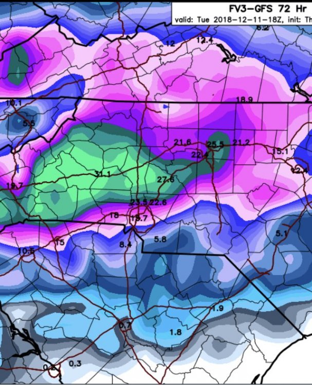
GFS Kuchera map is 12-16" in the Triad.
-
Yeah...If the precip can start earlier like the GFS, then that will up the snow totals considerably. Right now that might end up being the biggest hurdle. How long does it take to moisten the atmosphere? The GFS starts the precip a full six hours before the NAM and that 6 hours is all snow.
-
Yes!
-
It can be helpful to look upstream and see how a system is performing in relation to the modeling. I don't know how much it matters in this case, though.
-
One last frame from the Canadian for Monday morning:
-
-
It looks like another solid run from the Canadian at 18Z. A good snow for the western/Northern Piedmont from about 6Z-18Z Sunday, followed by a transition to sleet/Freezing rain for some...then back to snow with a good deform band Monday.
-
No---sorry if I worded that incorrectly. It's the oppsite. It was going bonkers with precip (1.5" qpf)/snow 24 hours ago and some areas are going to end up with zilch.
-
FWIW, and it may be totally unrelated, but it's interesting that it appears as if the NAM totally busted on the high side out in Oklahoma. Just brutal for some of those areas. Maybe it will bust here equally bad on the low side.


