Poimen
-
Posts
2,150 -
Joined
-
Last visited
Content Type
Profiles
Blogs
Forums
American Weather
Media Demo
Store
Gallery
Everything posted by Poimen
-
RAH did mention the possibility of snowfall totals near one foot in the Triad. So there's that.
-
RAH with the winter storm watch west of Raleigh.
-
overall a much better run for the NAM. Going forward I'd like to see if it can moisten the column sooner, allowing for more snow on the front end.
-
By 18Z Sunday the NAM has a sleet sounding over the Triad with a pronounced warm nose above 850.
-
The NAM has an incredible virga storm over the Piedmont Saturday night as it has a really dry air mass above the surface. The column finally saturates by 12Z Sunday in the Triad and the sounding is all snow.
-
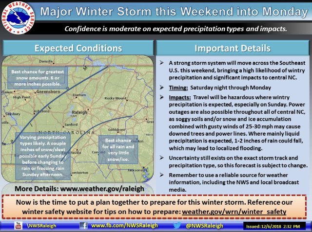
“Major Winter Storm”
-
yeah...the ARW cores had a mean snowfall of 11.63" though.
-
Does anyone care about the SREF plumes at this range? GSO snow mean is 8.3" and qpf is 1.56"
-
This sounds like inside info. Am I right?
-
I suppose you can add the 12z Canadian to that list as well.
-
I don't disagree. Still, will be interesting to see how it verifies.
-
As others have stated, this will be a big test for the FV 3.

-
Here's the best I can do:
-
which model are you referring to?
-
-
It's the "GFS" on this site: http://mageval.ncep.noaa.gov/ It updates very quickly on the NCEP site but the site is not as user friendly.
-
You are right...but what you're not understanding is that the models have been cooling the atmosphere from the top down as the precip and lift moves in. Perhaps the better discussion is if that scenario is plausible/likely.
-
This is going to be a really big test for the FV 3. I'm curious to see how accurate it is. It has not wobbled one bit that I can recall in recent days. Going off the crude 4 panel NCEP maps, the 12Z looks like a good snow event for the western/northern Piedmont of NC. It also still has some leftovers on Monday.
-
Dude...no offense but you're as predictable as the day is long. We are willing to concede that you are on record poo-pooing this entire event for everyone who is in it while you only dream of snow in Wilmington.
-
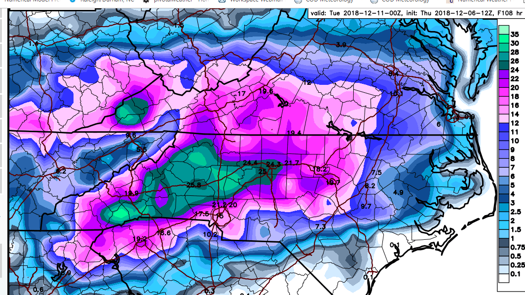
One last image from the Canadian, this is the deform band on Monday. Overall a really good run for folks along I85 north of Charlotte up to the Triad and parts of the Triangle.
-
Oh Canada:
-
The NAM just fired a warm nose warning shot,..as you all know. But I wonder since we're dealing with dynamical cooling if the NAM's lack of qpf played a role in that outcome? Will want to see how the NAM trends in these departments going forward.
-
warm nose on the soundings was above 850.