Poimen
-
Posts
2,150 -
Joined
-
Last visited
Content Type
Profiles
Blogs
Forums
American Weather
Media Demo
Store
Gallery
Everything posted by Poimen
-

MO/KS/AR/OK 2025-2026 Winter Discussion
Poimen replied to stormdragonwx's topic in Central/Western States
I'm pulling for you guys to my south. Best of luck to all of you. -
MO/KS/AR/OK 2025-2026 Winter Discussion
Poimen replied to stormdragonwx's topic in Central/Western States
https://x.com/bam_weather/status/2014120141697769771 -
18Z EC is a beast of a storm. The FZRA potential is something to keep an eye one.


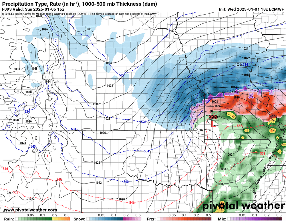
-
Here are the last three runs of the SREF:
-
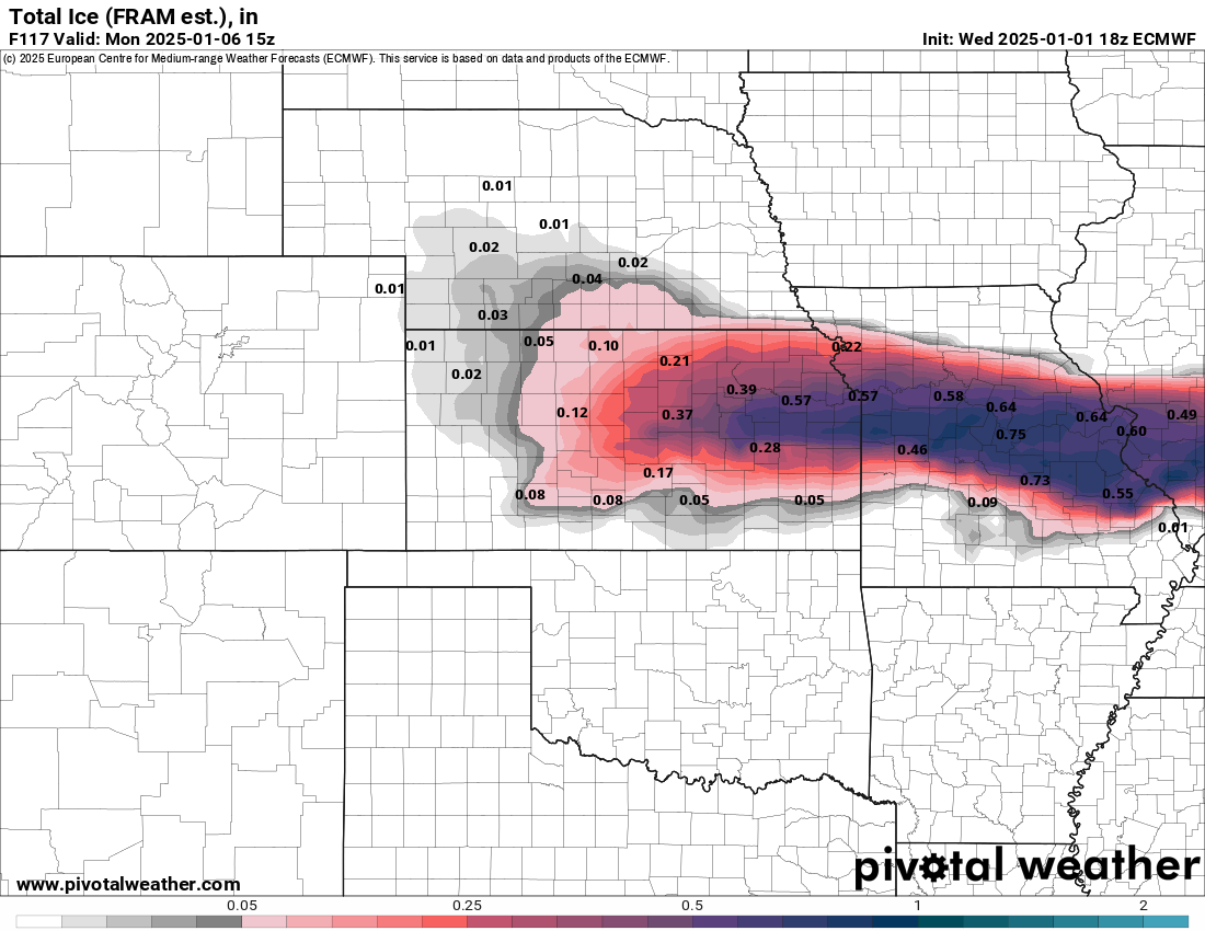
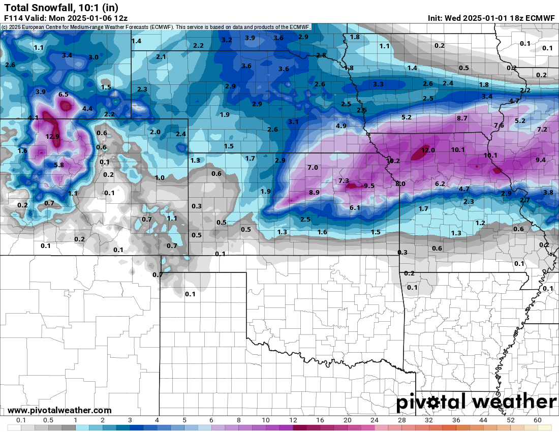
For what it's worth: the 9Z SREF run has a noticeable uptick in qpf for much of the area. In fact, the snow plumes for K.C. jumped to a mean of 5" at 9Z. The mean was 1.5" in the previous run. This should result in a noticeable uptick in qpf for the 12Z suite of NAMs. We'll see.
-
According to the afternoon AFD, the Topeka office is forecasting 20:1 ratios.
-
Here's the 10:1 snowfall output from the 12Z EC. These were higher than I thought it would be. I suppose we can expect ratios greater than 10:1--but I've lived my whole life in the south where 8:1 ratios are the going rate. I've never seen soundings like the one's I'm looking at now.

-
I've been loosely tracking the GFS Kuchera totals for my backyard. It just went from 17-20" in the prior runs to 5" on the 12Z. Don't get me wrong, I'd be happy with 5" of snow, but the trend this morning seems to be a quicker and less amped system for this area. Still plenty of time for things to change.
-
Hey guys. I recently relocated from North Carolina to the Northland of K.C. (MO). I'm looking forward to experiencing my first midwest winter storm (hopefully). Thanks for all the info here.
-
I never thought I'd consider sowing fescue in late December, but it is tempting right now...
-
@lilj4425
-
Another 2" qpf run for the RAP with 18" snow totals in the Triad. HRRR isn't far behind.
-
2” per hour rates in the Triad at 9am per the HRRR
-
The 22Z RAP has 2" qpf amounts just south of the Triad and 17" snow totals in the Triad.
-
RAH doubling down in the Triad
-
Holy crap GFS. 1.8" QPF here by tomorrow afternoon.
-
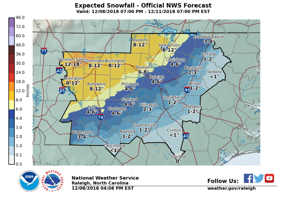
For the Triad, there is more or less a consensus for snow beginning around 1 am and continuing as all snow through 11am-noon, before mixing with and changing to sleet. We'd have to pull 1" per hour rates just to get 10-11". Experience says that is unlikely. So we're probably looking more like 7-9" on the high end, with some sleet on top. That's my call, but I'm of course hoping for more.
-
Got an mPing of snow in Clemmons (near Winston). I'm not expecting it, but it would be nice if we could get things started earlier than ~1am here.
-
SREF snow mean for GSO is just under 10".
-
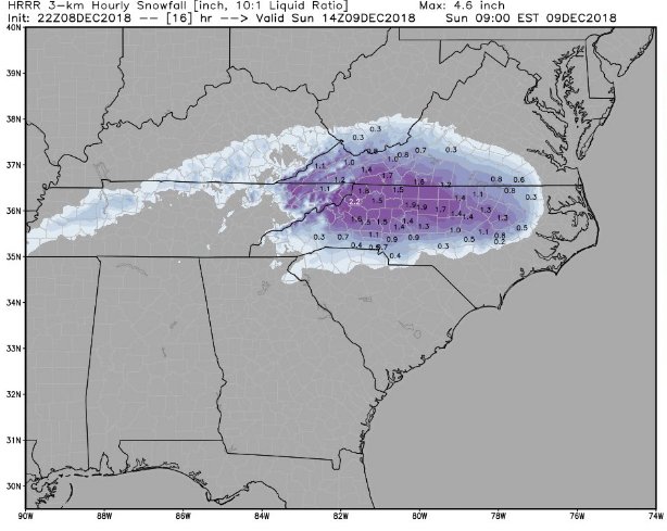
Here's the HRRR through 18z:
-
Literally, the 18Z HRRR is snow from the Triad to RDU from roughly 1am to 10am. After 10, it transitions to sleet at RDU before rain around noon. It does bring sleet into the Triad by 11-noon,but by then 12 or more inches of snow has fallen.
-
The RAP...FWIW...through 15Z tomorrow has nearly 1" qpf in the Triad, all of which should be snow per model soundings. It does have the 700 and 850 mb warm nose, but it keeps it confined to the SW Mountains, over to Charlotte, and then NE toward the Triangle.
-
Same as above, this time at 850mb:
-
Top image is the last frame from the most recent HRRR at 700mb. You can see the warm nose very clearly. Bottom image is from the 12Z NAM at the same time. Both models have it, but the NAM is more pronounced.