Poimen
-
Posts
2,150 -
Joined
-
Last visited
Content Type
Profiles
Blogs
Forums
American Weather
Media Demo
Store
Gallery
Everything posted by Poimen
-
Bet it was the 700mb temps on the EURO.
-
A question: I'm wondering if the last few cases of warm noses winning out occurred in conjunction with a similar well-placed CAD?
-
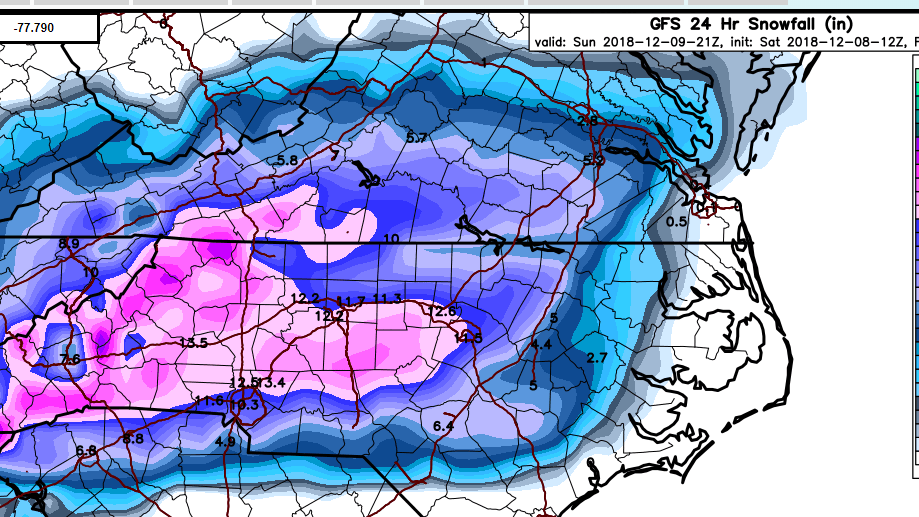
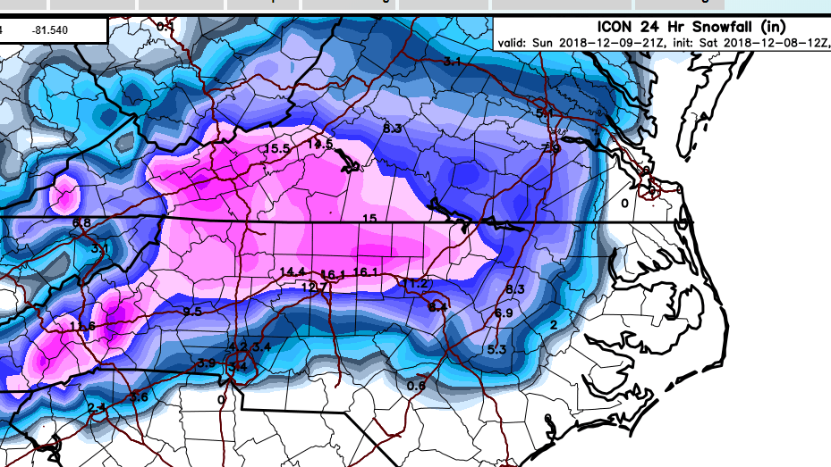
GFS and ICON clowns:
-
Actually...looking at the RGEM charts, it is blow torching at 850 by 12Z tomorrow. This is way warmer at this level than any other guidance and makes me a bit suspicious.
-
The upper level low is really a non-factor for our snow chances, in my opinion. It's all coming down to how the models resolve the 700mb low as it approaches and passes through the SE. The NAMs/RGEM have a pronounced warming at this level, whereas the RAP/HRRR are, for the time being, limiting the amount of warming over NC. Who will win? Only time will tell.
-
Looks like the RGEM is going to follow suit on previous runs with sleet well into the mountains and Triad. It probably has the same 700mb warm nose as the NAMs and is a huge red flag in my opinion.
-
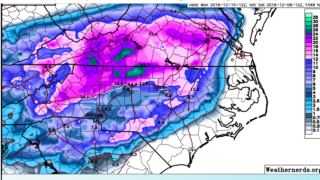
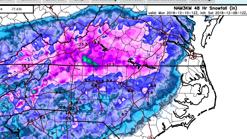
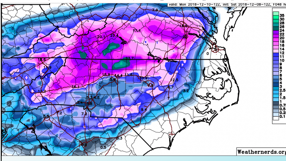
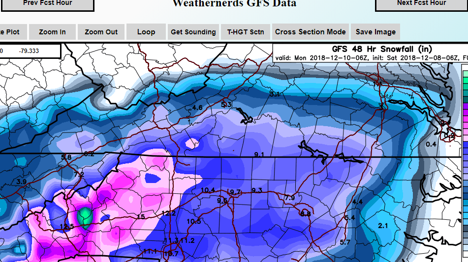
3K and 12K NAM respectively:
-
I'm riding the 12Z HRRR until it tells me otherwise:
-
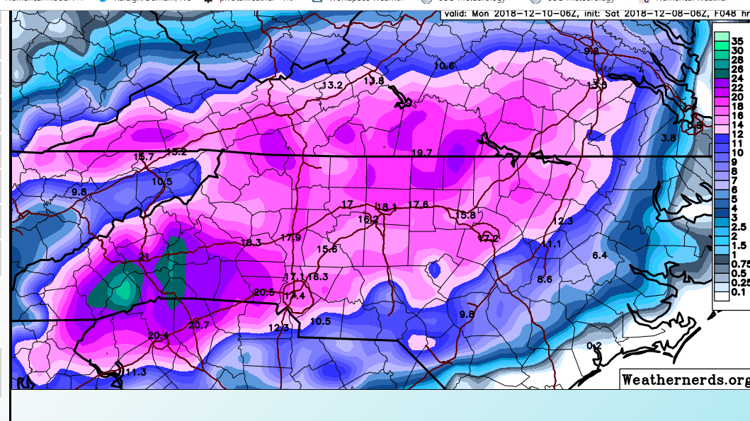
3K NAM much more of a warm nose up into the Triad. A lot of sleet after about 15Z.
-
10 of the SREF members are between 12-17" for GSO. This is a big jump.
-
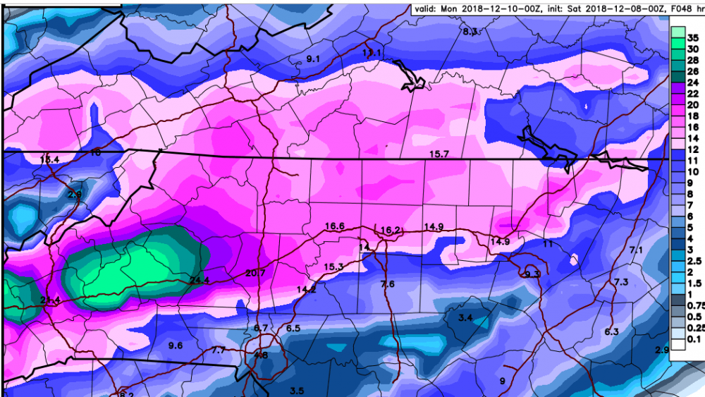
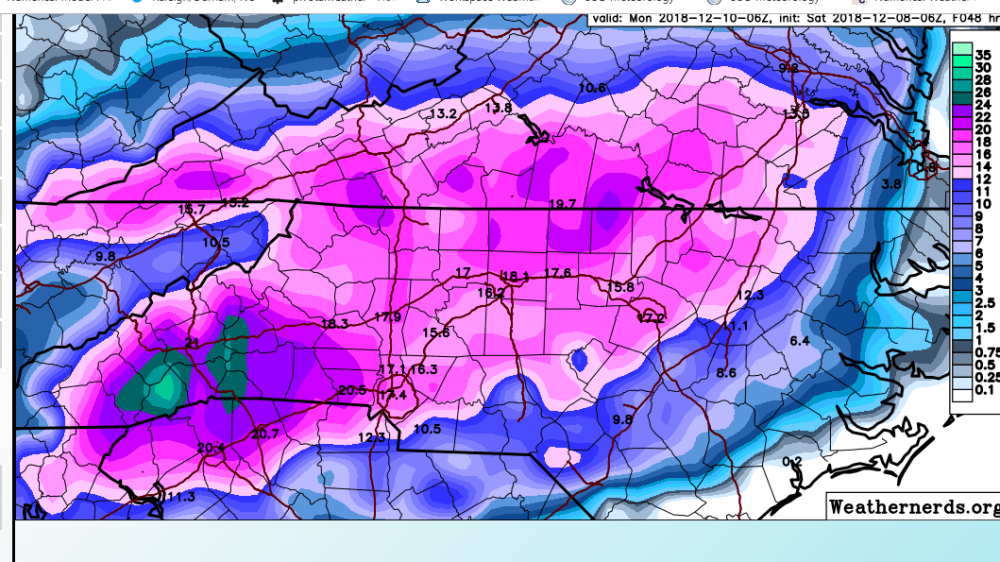
The NAM is better than previous runs but it does have a pronounced warm nose coming through at 700 mb. It looks like the warm nose affects areas from Charlotte to RDU and points just south of 85 in the Triad. HRRR has the same warm nose, but less pronounced and stays well south. Also of interest is the 9Z GSO SREF. Snowfall mean jumped to 10" and total qpf mean around 2." Altogether an encouraging run of models so far for many of us.
-
How does the HRRR compare to other Hi-Res models, specifically in regards to thermals? Edit: @griteater just answered above lol
-
6Z FV3; GFS; ICON. Of the three, the ICON is most encouraging to me. It had it's best run yet for the Piedmont.

-
The NAM/RGEM concerns me for the NW Piedmont portion of this forecast. But we shall see:
-
The NAM soundings indicate the problem may be a loss of saturation in the snow growth zone more than a warm nose. Either way, this is pause for concern.
-
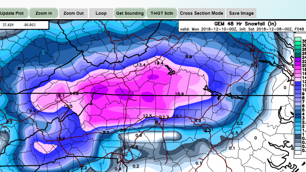
Last one for the night, the GGEM. Just about every model has between 10-14" in the northern Triad.
-
The ICON:
-
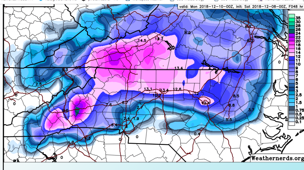
FV3 has lowered it's qpf some...but still pretty beefy. I'm guessing this is close 1.5" in the Triad, which is in line with other guidance, except the GFS.
-
You know it's a good night when the worst model runs only give you 10".
-
Without soundings it's hard to know what's going on. Maybe it's an issue with the program indicating sleet when it's actually a snow sounding? I mean it was showing sleet on the maps even over the mountains and we know that's not the case. It still has 8-11" in our neck of the woods.
-
But then again...according to the PW site, the RGEM is a sleet storm for the mountains, too. Perhaps that answers my original question?
-
Should the RGEM concern us? It's basically a sleet storm for even the Triad. I seem to recall that it has performed well in the past.
-
It's supposed to be.
-
Not to be out done is the 12K NAM: