The 4 Seasons
-
Posts
7,985 -
Joined
-
Last visited
Content Type
Profiles
Blogs
Forums
American Weather
Media Demo
Store
Gallery
Everything posted by The 4 Seasons
-
I miss the days of sand, salt is terrible for the vehicles but more effective in treating the roads
-
I had felt like i had a stroke reading this. Costalwx figured it out though, went over my head
-
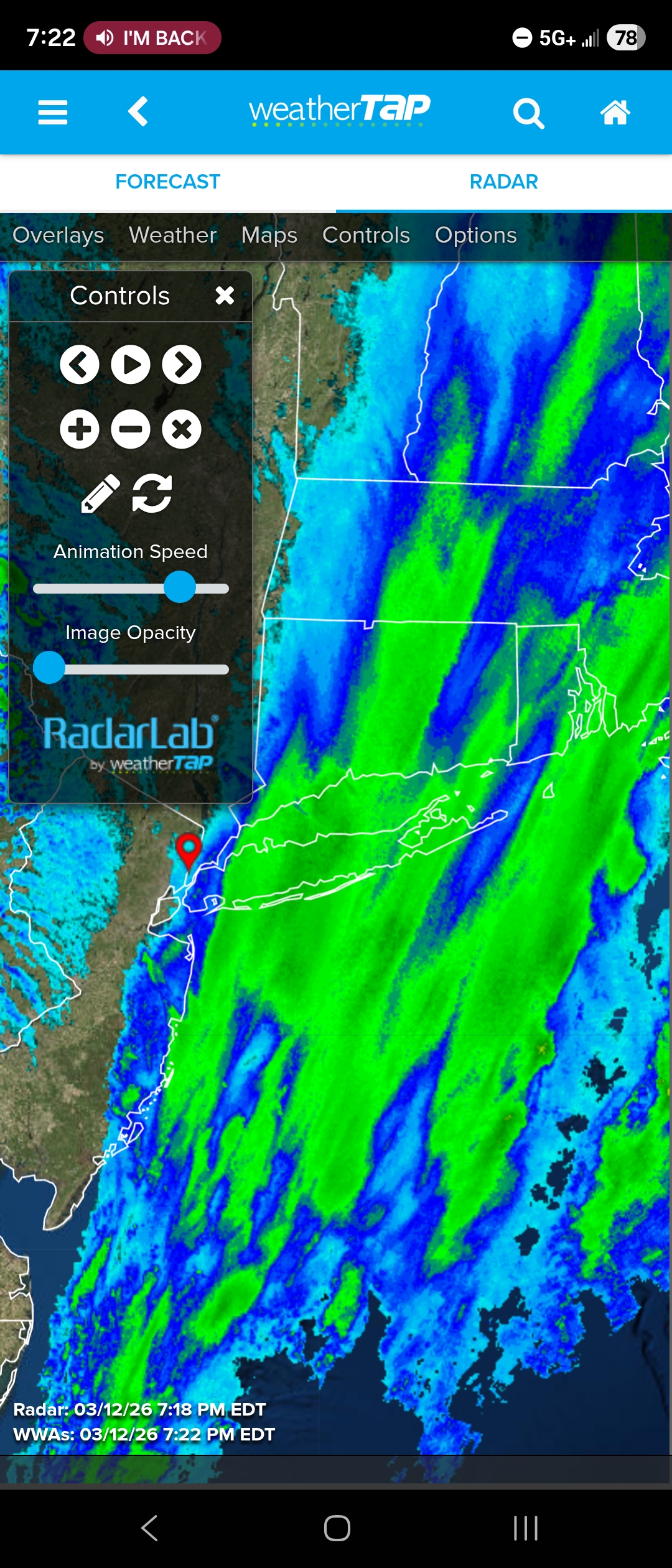
Zero snow..phantom radar, might be light rain/snow but I don't see anything despite the radar being lit up

-
Just wanted to shout out similar archives that have snowfall maps for many significant storms that i never knew even existed until i started working on this last year, except Ray's which is very prominent. A lot of them were helpful in finding additional snowfall reports for past storms. I will add this to the first post on this thread as well. Snowstorm Archives Ray's Winter Storm Archive - NJ Mercer Co (PHI/OKX) focused, 1993-2013 Rutgers State Winter Storm Archive - NJ State (PHI/OKX) focused, 2002-present Steve LaPointe's Weathernet6 Archive - NY Capital Region (ALY) focused, 1993-present Eric Webb's Archive - NC (RAH) focused, 1885-present NWS Snowstorm Archives OKX Significant Weather Events BOX Significant Weather Events ALY Significant Weather Events PHI Significant Weather Events Significant Storms Reanalysis Tomer Burgs PolarWx Archive - Reanalysis of past storms
-
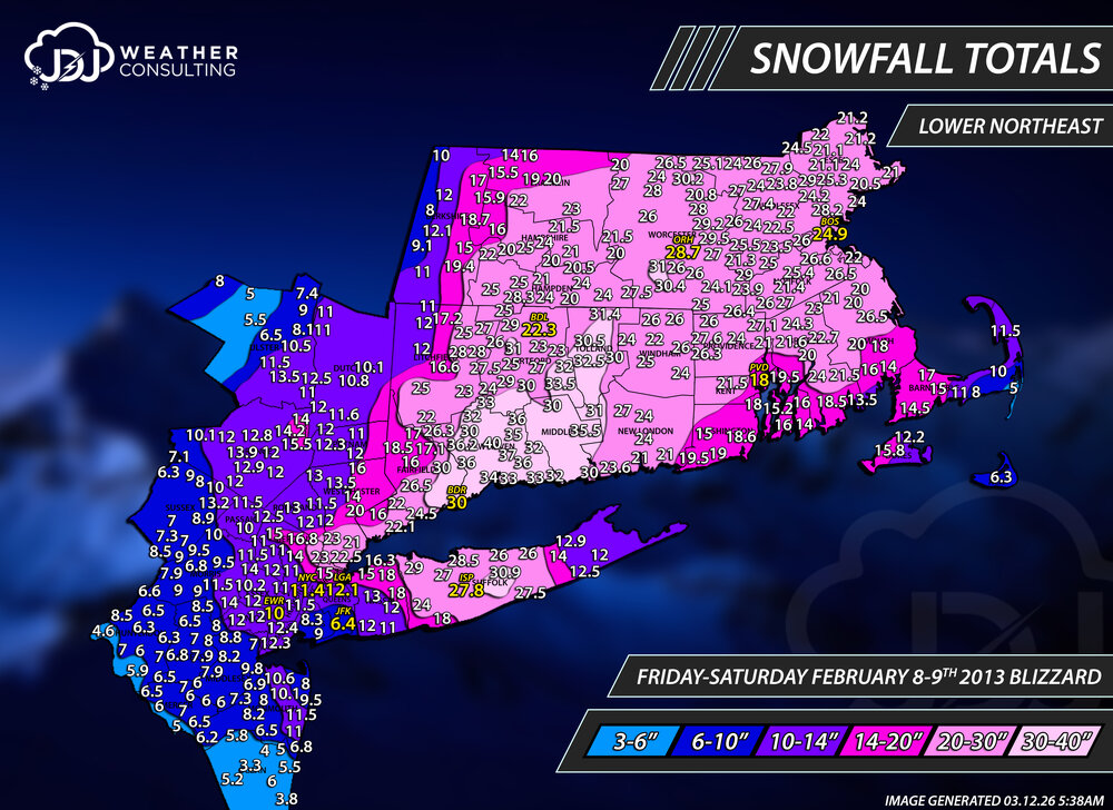
I remapped and updated Feb 2013 Blizzard, Jan 2000, Feb 2007, Dec 2010 (Boxing Day) and Jan 2022 as well as added new L. Northeast maps for all events.
-
That was my suspicion as well, though it is never noted on any of the PNS from BOX during that time and the data is missing in the now data F6. Do you think it would be fair just to label those as BDL on the maps im doing for that time? Ill wait to see what @H2Otown_WX says
-
great, thanks. I'm curious about that because like every PNS has East Granby as an ob, which after those missing years you rarely see.
-
But when we are grading the winter its just for our area or town no? Who cares about the rest of the region E MA/N MA/RI etc...respectfully. I'm sure they'd say the same thing when grading their local area. So with that said, we did get a sig event in December 6-10" is a big deal and overall December was well above average with 12-16" around our areas. I think you meant Jan 05. Jan 2005 wasn't a bust per-se but it was a garbage blizzard overall for most of CT. If that happened today, people who consider the Blizzard of 2026 meh or a let down, would be absolutely be bridge jumping if that repeated. Leading up to the storm most models were dumping 2-3" of qpf over CT and most forecasts were for historic territory with 15-30" at the time. What happened was a long duration, light to moderate snowfall with zero verified blizzard conditions for CT, maybe GON? I dont think we ever got above moderate for snowfall. BDR reported -SN to SN the whole time. I remember the deepest drift i could find was about 18" with mostly ~8" in non drift areas. I dont know where the snow went or what happened but reports are all 12-16 around here. Either way, that was still way under what was expected. Same thing with Dec 2003, which was worse Check out the radar here its a joke compared to 2026. https://www.jdjweatherconsulting.com/jan-22-23-2005 https://www.jdjweatherconsulting.com/dec-5-7-2003

-
Hey @H2Otown_WX could you help me out with something? There is notorious missing data from BDL from 1996-2002 on the F6 and climo data. However, i have this theory and suspicion i wonder if you could verify or deny it. There are a lot of reports from around that time on the PNS from BOS during significant snow events and almost always lists East Granby. Kind of strange that during that missing data time East Granby is always there but Windsor Locks is not. Did BDL once report from East Granby? When i checked on google maps Bradley International spans over both towns. So it would make sense that it was once reported as "East Granby" instead of Windsor Locks. Though that still doesn't explain why a lot of data is missing. Just a theory, thought you might know or could find out. Thanks.

-
We have a chance like Jim Carrey... In all serious though, i saw it, something to keep an eye on, seems like this winter wants to snow late month every month...
-
We'll see how the rest of Mar and Apr goes but it can't be lower than A- currently for many a reason. There's really no other winter i can think of overall better than this except for 95-96 and 10-11. Another 1-2 Mar/Apr adv or warning events and ill bump it up. Also no major busts, which is rare for any winter season. Most of our good or great ones had a couple. It's a lot like 2000-2001 with better snow pack. Strictly snowfall amounts yeah, but 04-05 was seriously back loaded. Probably 50-60% of our snow occurred from late feb to late mar that season. Each one melted right after it happened. And the "blizzard" sucked balls for most of CT..hours of light to mod snow that slowly piled up with no blizzard conditions. 02-03 was great but had many many teases and near busts like Dec 2002 christmas blizzard, Jan 2003. Also couldn't touch this season with snow pack. And we ended the season on a major Apr 7th bust. 02-03 was like 95-96 lite with wall to wall snow from Nov to Apr. Both those seasons were good-great but had plenty of problems, i think this winter is better overall, just my opinion.
-
thanks I just finished remapping and updating Boxing Day 2010 storm if anyones interested. There is also a new Lower Northeast map with all the climate sites on it as well as a bunch of extra images and maps related to the storm https://www.jdjweatherconsulting.com/dec-26-27-2010
-
BTW the new OKX storm archive is up, they changed the URL to something different so i know why my link was broken now used to be /stormevents still mostly ends at 2015, for earlier you have to use the wayback machine, and the links on there dont even work https://www.weather.gov/okx/stormarchive
-
The internet archive is a beautiful thing and total non profit organization like Wikipedia. It crawls the entire web, you can even find our little site on there and see the progress and how its changed over time. I never even thought to look at it for these past events pages that have been taken down over the years from OKX and BOX. It's shame the NWS don't have the server capacity to keep them up. That's why a lot of their stuff is offloaded onto IEM (Iowa State) where you can find pretty much every product from the past.
-
2 foot+ per season in ORH is wild, they really do grow on trees there. How do you calculate this? And what i mean is how do you know when an event 3+ or 6+? Say for example if the daily climate data had 5.9 on one day and 0.3 the day before? Is that 0.3 from an unrelated snow shower early in the morning or was it 0.3 just before midnight and connected to the same storm. Is it a 3-5.9" event or 6+ event? I know a lot of storms are spread across 2 days, sometimes 3 so im curious how you'd figure that out. unless you are using your memory and cross checking radar and other stuff...i feel like this would be difficult to do beyond what one can remember. Just doing daily X-amount is easy, but by "storm" its a lot more difficult...unless you're keeping track in real time except for the 50s-70s.
-
-
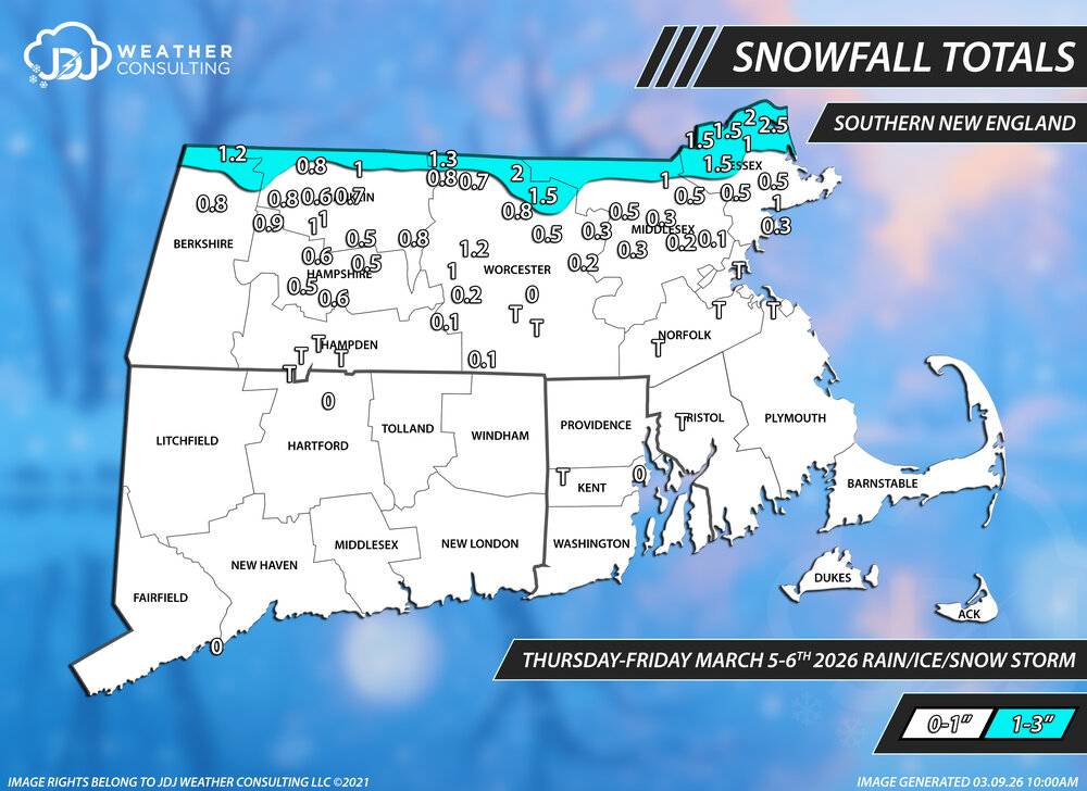
Snowfall totals from this event...thrilling stuff A little odd to me that ORH didn't even report a T for this event, just a big zero. All the SNE snowfall maps for this season are up here, so far there is 24 events https://www.jdjweatherconsulting.com/sne-25-26
-
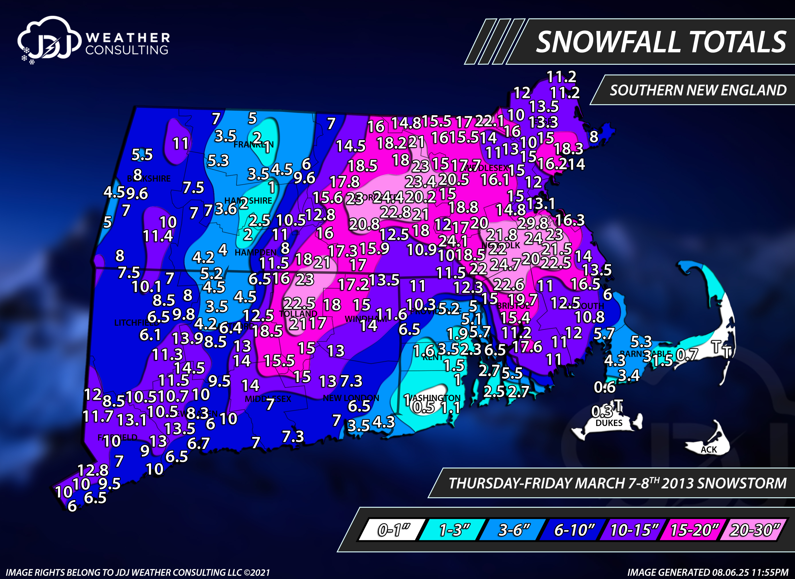
Brutal gradient. 4.5 BDL, 1-3 near 91 in MA https://www.jdjweatherconsulting.com/mar-7-8-2013

-
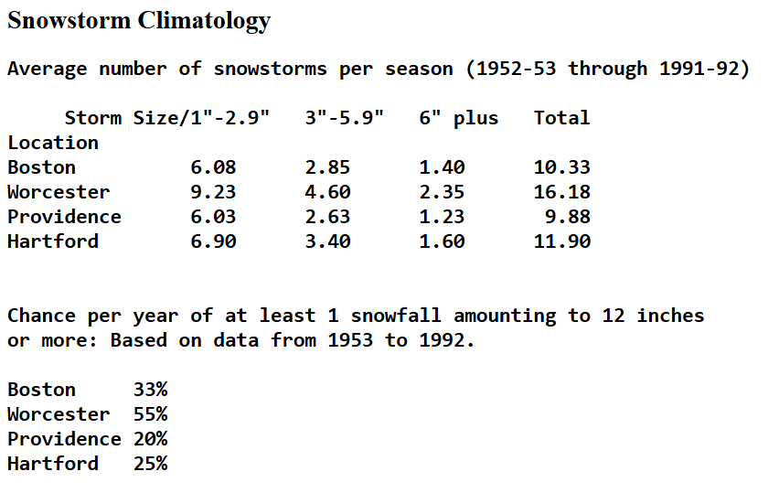
i finally found this stat! i always remembered and referenced these numbers but never knew where i saw them. Boston is about 1/3 seasons for a 12"+ event, ORH is about 1/2 and BDL is 1/4 and NYC though not on that list is about 1/5. I'm sure these went up considerably since 1992, probably by a lot.
-
that makes more sense
-
why is this all crazy looking
-
great, thanks! that page brings me back I found the one from OKX that they deleted as well. Can't click on the links but i can at least see them https://web.archive.org/web/20151031235410/https://www.weather.gov/okx/stormevents
-
8 years ago today. This was an incredible short duration storm here that was one of the 5 or so that i've experienced thundersnow. This one (and Feb 2001) was some of the most intense close proximity thunder i've ever seen. The other few like Feb 2017 and Feb 2003 were more distant rumbles of thunder. Not this one. I happened to be outside when it was snowing hard around 7-8pm or so. I was looking down and all of sudden a bright white flash engulfed my surroundings. For a split second i couldn't compute what was happening, i thought it was maybe a flood light or something. Then very quickly BOOM a super loud convective clap hit like it was summer. I looked up and saw multiple CG strikes after that in the distance. Had to be very close by because the delta was <1 second and i could see the lightning strikes. Only time i was ever outside and saw thundersnow. We picked up about 13.5" in just a few hours. I'll be remapping and touching up this storm at some point soon. Radar and other maps: https://www.jdjweatherconsulting.com/mar-7-8-2018
-
Only 8 months till November.
-
I go through the same thing I send them pics and never do they use mine but another spotter in north haven who's always higher. Weird how North Haven jackpots all the time..