The 4 Seasons
-
Posts
7,985 -
Joined
-
Last visited
Content Type
Profiles
Blogs
Forums
American Weather
Media Demo
Store
Gallery
Everything posted by The 4 Seasons
-
https://www.jdjweatherconsulting.com/mar-13-15-2023
-
would you happen to have a report there for March 13-15, 2023 long duration elevation snowstorm? @snywx as well
-
seems about right. That will help me.... i was close just have to move the 3" line down a bit
-
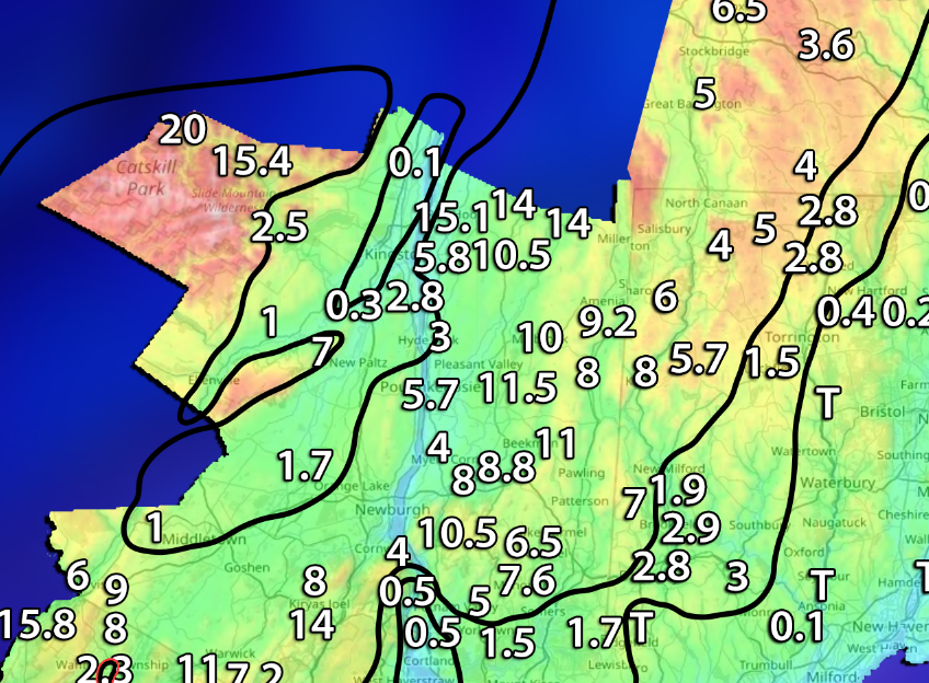
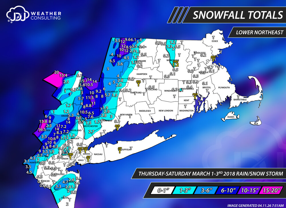
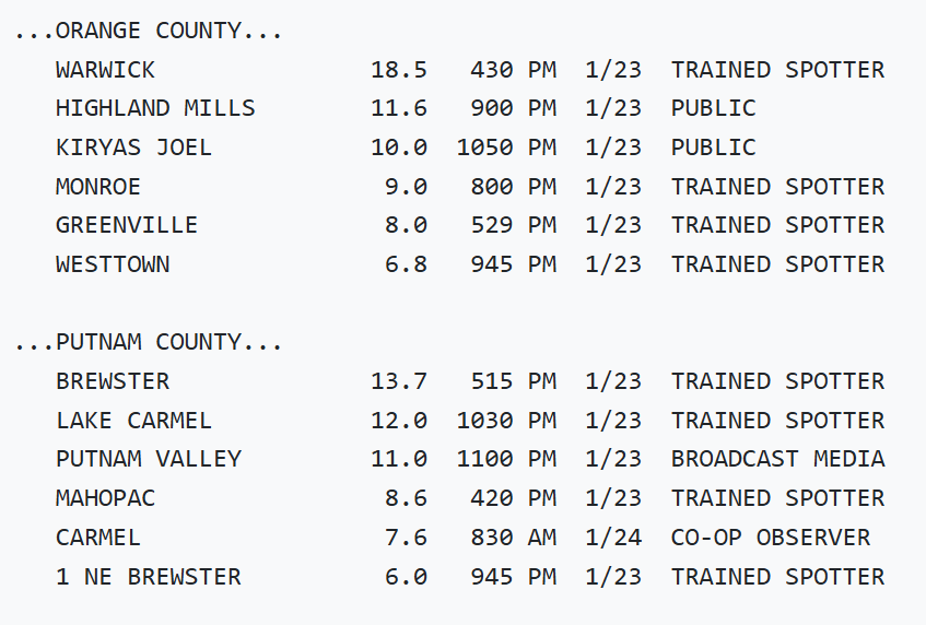
A report from Campbell Hall from Mar 1-3, 2018 would be helpful. I feel like im walking in the dark in some areas with such an extreme snowfall gradient
-
Since you're active i wanted to ask what was your final for March 13 2018, i thought you said 31 but the PNS has 28.3
-
58 already at 11am probably push 60
-
Are we ever going to get NESIS map for this event or are we just going to ignore it? It's obviously more than a cat 1 based on other storms in this list. Easily a 2 but most likely a 3. They were quick to do one for Feb 22-23 but just skipped this for some reason. https://www.ncei.noaa.gov/access/monitoring/rsi/nesis
-
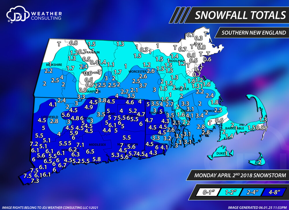
thanks for posting this 8 years ago today. The fifth and last snowstorm of the season. A low end warning event for most of CT and Tri-State after the 4 nor'easters of March 2018. https://www.jdjweatherconsulting.com/apr-2-2018

-
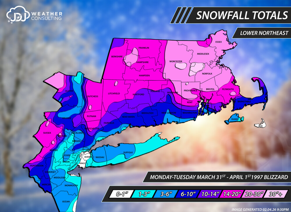
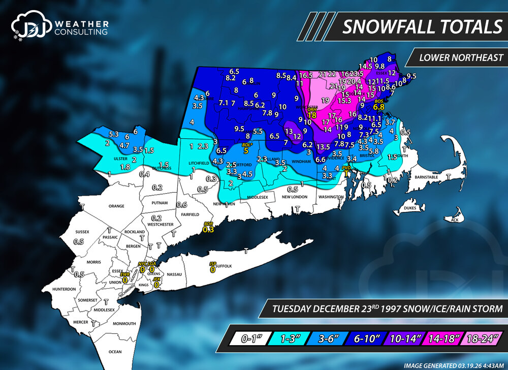
29 years ago today. I posted these updated maps a couple months ago when we were discussing this storm a lot. Here's the link to all the maps and other images related to the storm. Also have a few radar animations https://www.jdjweatherconsulting.com/apr-1-1997
-
The majority of the historic storms have been updated with these new maps https://www.jdjweatherconsulting.com/historic-storms
-
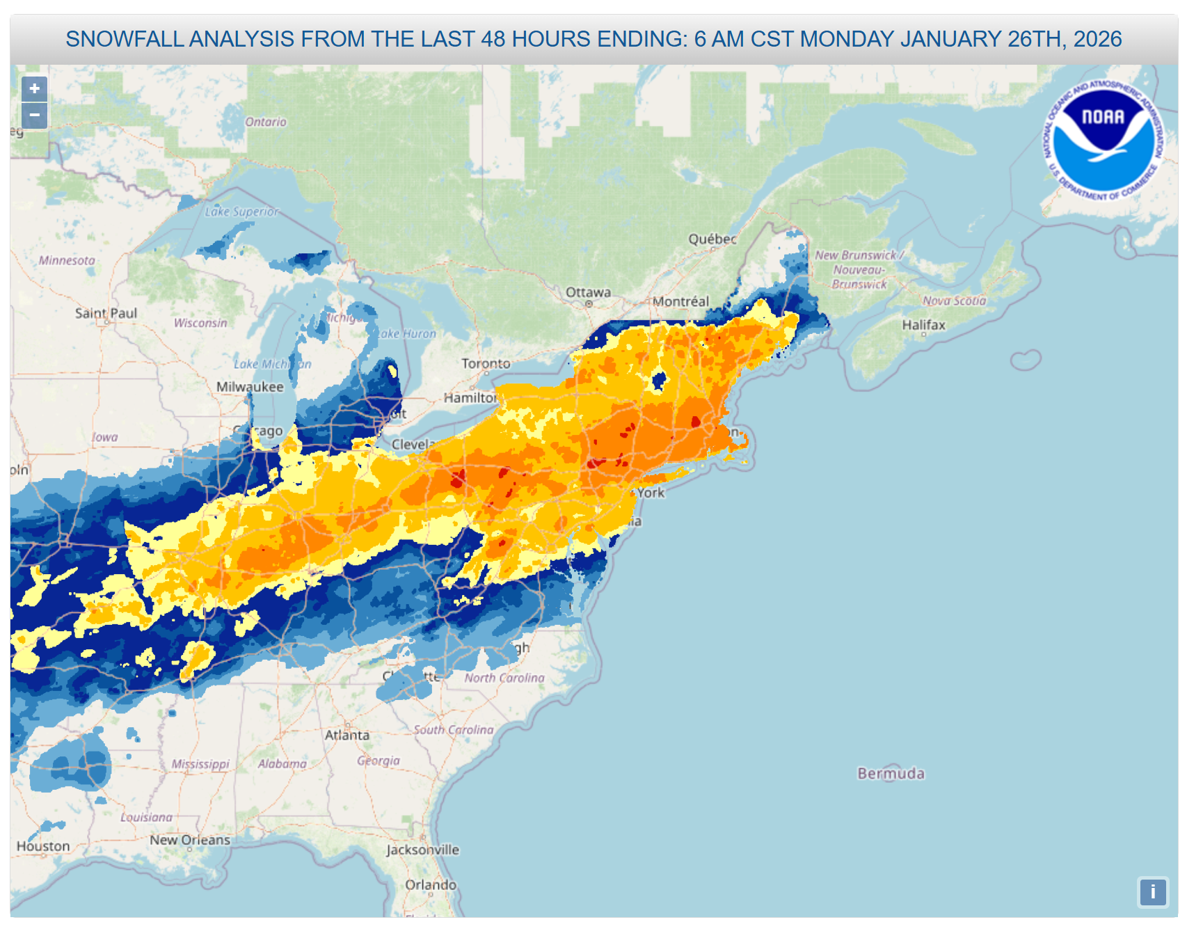
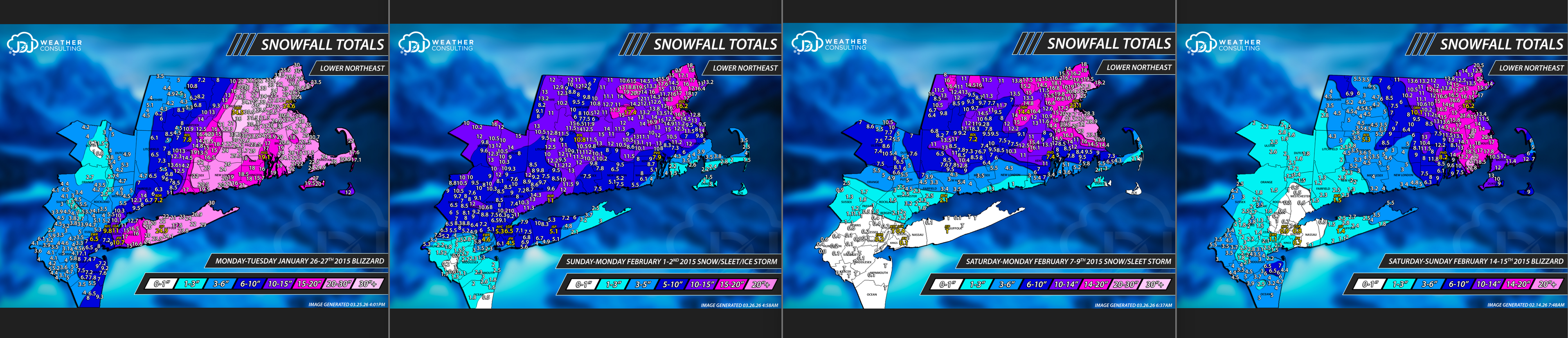
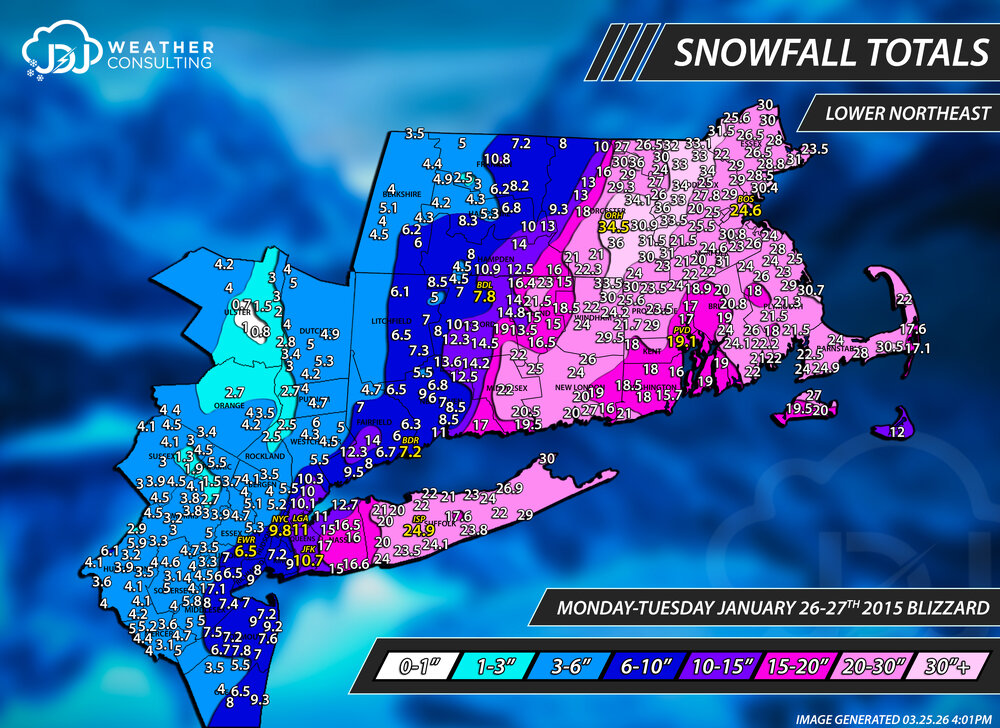
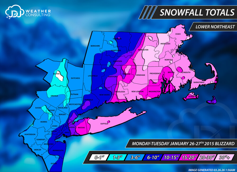
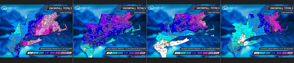
With this dead March we've been having i had some time to work on the website and archive. I've updated about 70% of the historic snowstorms section and added new Lower Northeast view maps for those. I also created a new page for L. Northeast that will have all the events in that wide view. 2026 is up and 94-25 will be updated throughout the year. There's also a filter for contours only, all historic storms and storms >30" Website updates https://www.jdjweatherconsulting.com/historic-storms The 4 major storms of the 14-15 season
-
rough. dont feel bad i missed Feb 2013. And not only was that a major storm for CT, i am pretty much ground zero jackpot in that storm...
-
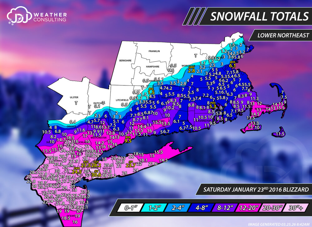
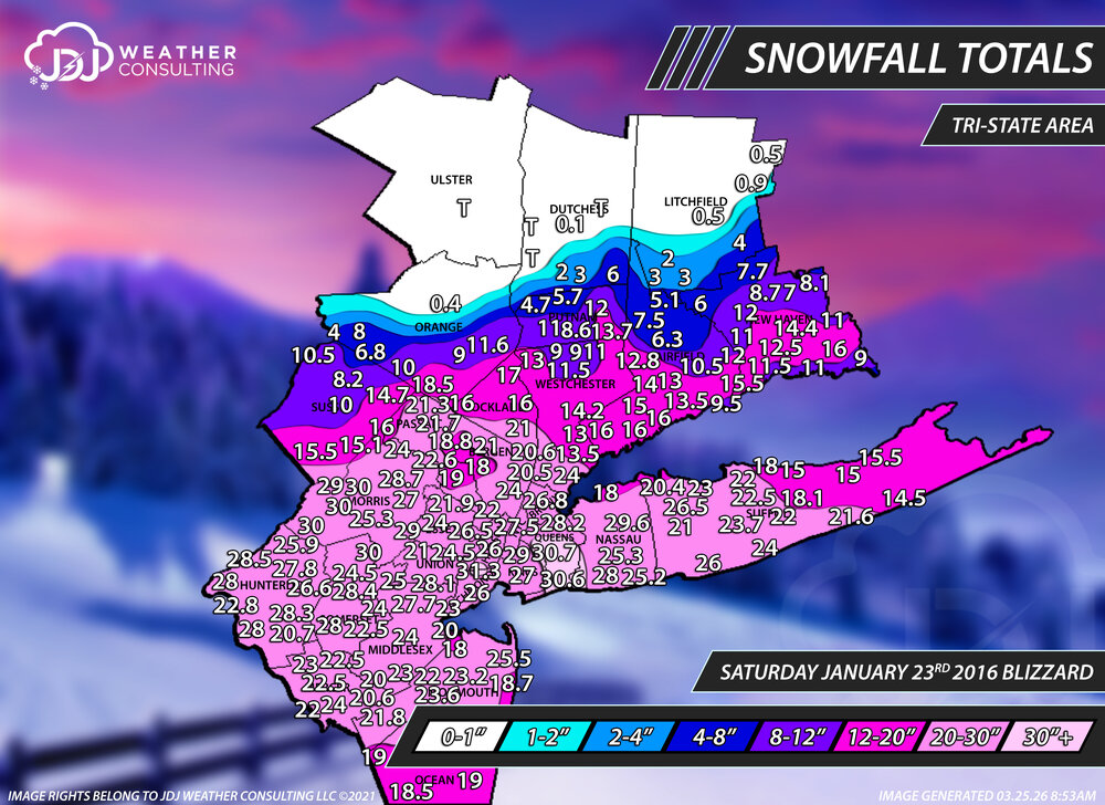
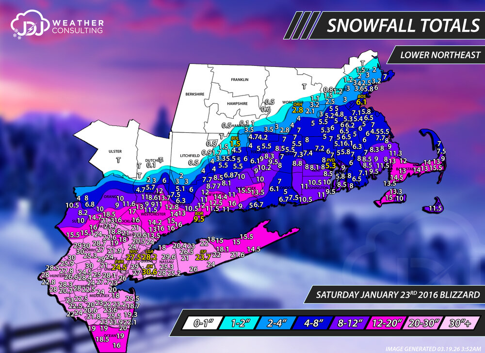
It's a pain to update these maps even for the most minor of changes but i couldn't let this be for Orange county. Razor sharp cut off https://www.jdjweatherconsulting.com/jan-23-2016
-
any report from Jan 26-27, 2015? @snywx as well
-
I'm very curious to hear from Middletown @snywx that would help
-
Yeah that is a very close measurement for a storm like that with wind and moderate to long duration.. that's kind of why I assumed it was you. You can get variations of 3-4" in a storm like this in the same town if one person is just taking the average depth at the end and someone else is doing 6hrly clearing and both are valid. So i was surprised to see it so close.
-
The PNS has 11.6 for Highland Mills, i am assuming that was you. I have it on the map. Are you sure about 11.2?
-
Jesus 0.4 from Campbell Hall to 11.2 in Highland Mills
-
@snywx @CPcantmeasuresnow
-
I figured id get some comments from orange county folks. I had to almost completely guess over there as there were hardly any reports. I can add your 0.4 and if I could get more from the other Orange country posters that would help
-
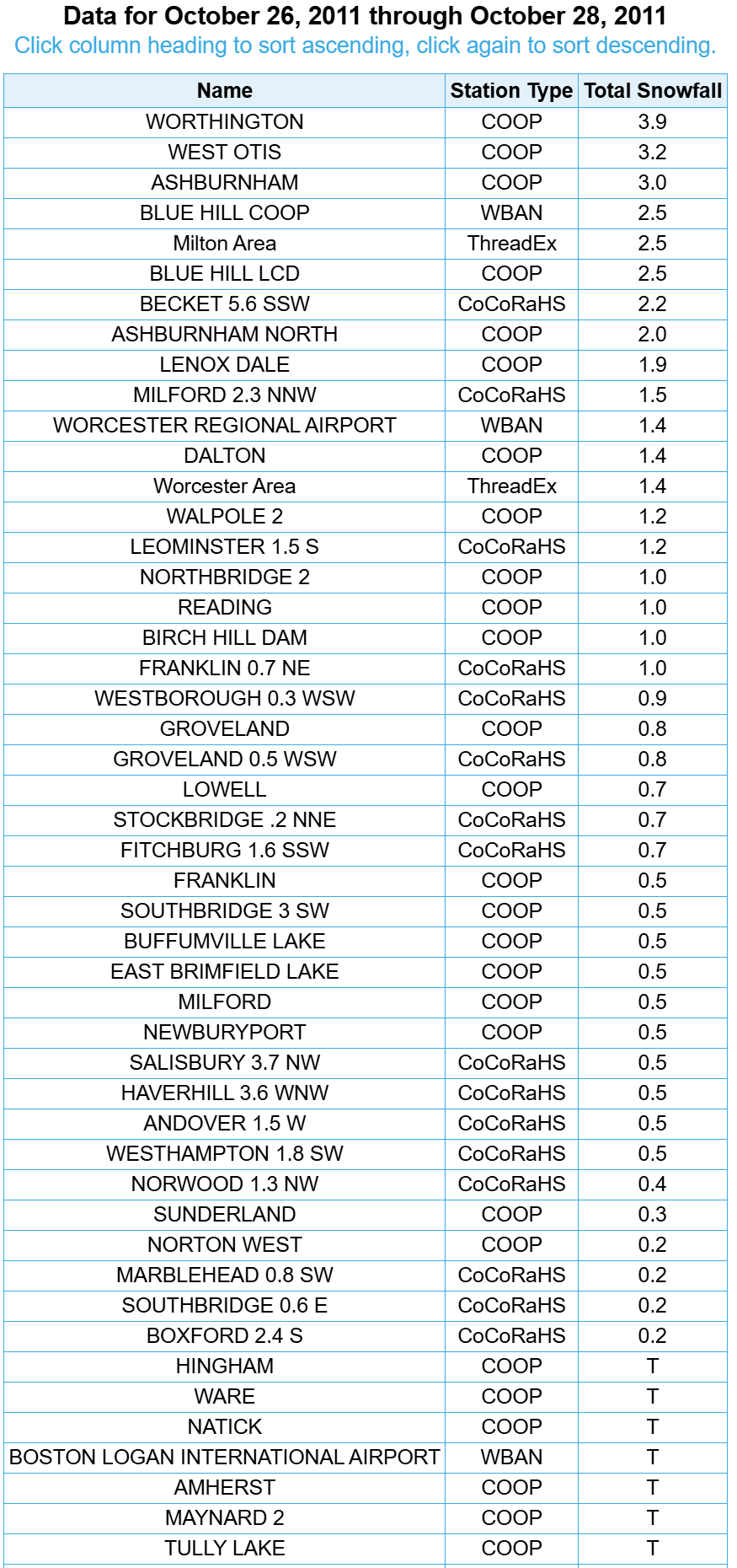
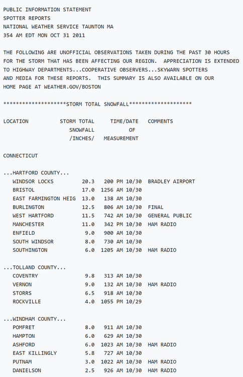
do you remember the snow event before the big storm? I had no idea that was even a thing, i just assumed (wrongly) that there was even an accumulating event before Oct 29-30th. Only far northern Connecticut in the hills picked up accumulating snow. Norfolk 2SW 2.5" Oct 27th, 2011

-
I updated several storms in the 97-00 period, i've been going back and forth on whether to include E. Granby for Windsor Locks ob. I decided to just label it with asterisk for that period. About half the storms in the Historic Snowstorms section have been updated and have new L. Northeast maps. https://www.jdjweatherconsulting.com/historic-storms
-
I updated one of our favorite storms of this sub-forum, and one of mine as well. Got into the meat of it in the CT band that rotated and pivoted overhead with a final of 14.4". Only 24hrs before hand we holding out hopes that the NAM & RPM were right. But last minute positive trends turned this into a major storm for 95 and a historic storm for the NY/NJ metro area. https://www.jdjweatherconsulting.com/jan-23-2016
-
lol
-
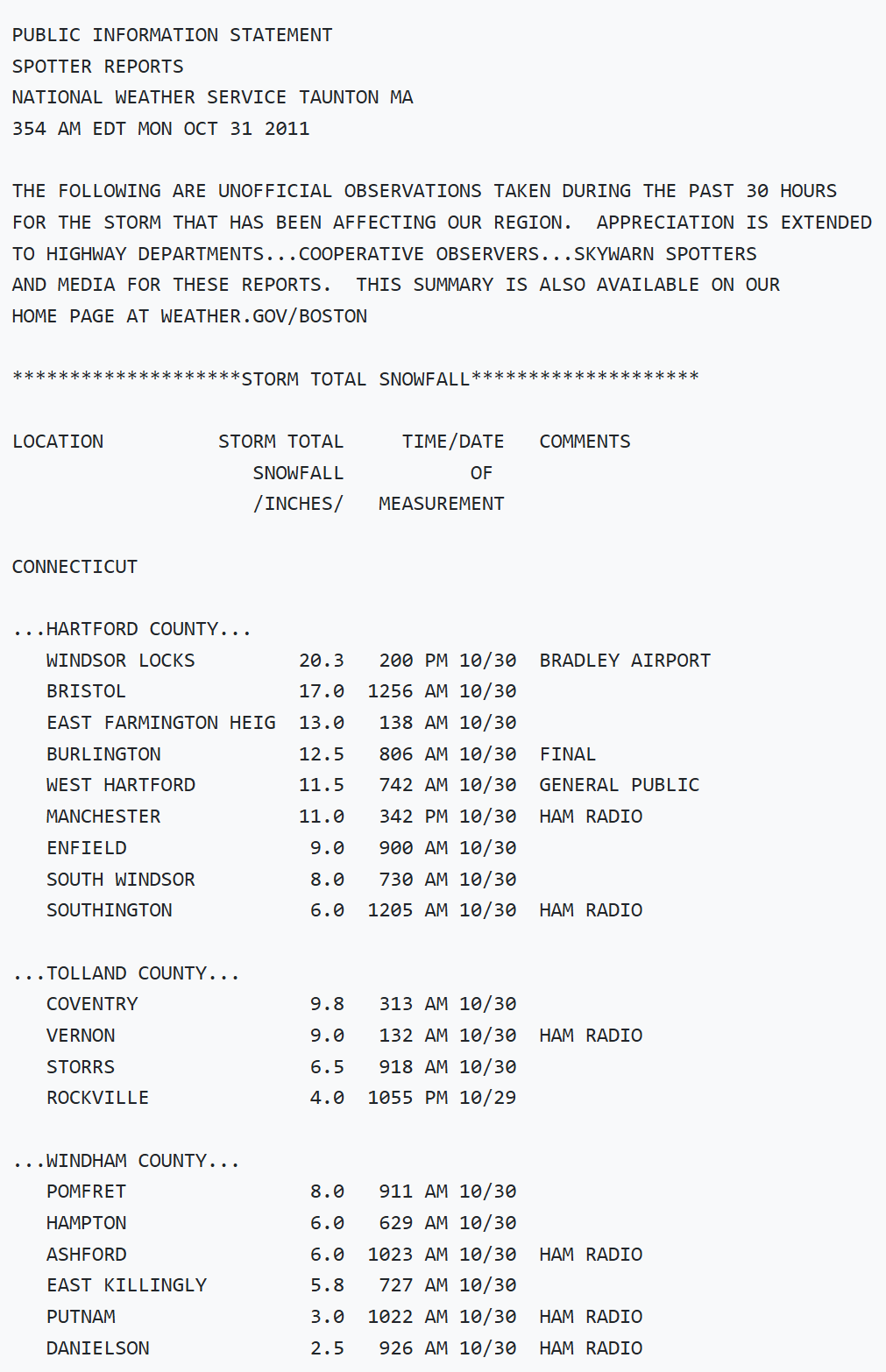
Another thing i just discovered is that there was a moderate event BEFORE the major halloween snow bomb of 2011. I can't believe that. I have to re-do that storm completely because a lot of the coop and cocorahs data i used overlapped for both events. When i've been doing these extremely anomalous late or early events in Oct/Nov or Apr/May i usually assume there is no storms that overlap on almost the same day or day before/after. Clearly i was wrong to assume that. On Oct 27th 2011 there was a 0-7" interior event that covered the Worcester hills, Berkshires and bled into NW CT in the Litchfield hills.