The 4 Seasons
-
Posts
7,985 -
Joined
-
Last visited
Content Type
Profiles
Blogs
Forums
American Weather
Media Demo
Store
Gallery
Everything posted by The 4 Seasons
-

2025-2026 New England Snow Recordkeeping Thread
The 4 Seasons replied to bristolri_wx's topic in New England
cool thanks steve i appreciate you reaching out and letting me know. i guess that 79.9 was from somewhere else or a typo? either way at least we got a cocorahs near by for now buts its technically not N Foster, its 4SSE Foster -
enjoy i NEED snow
-
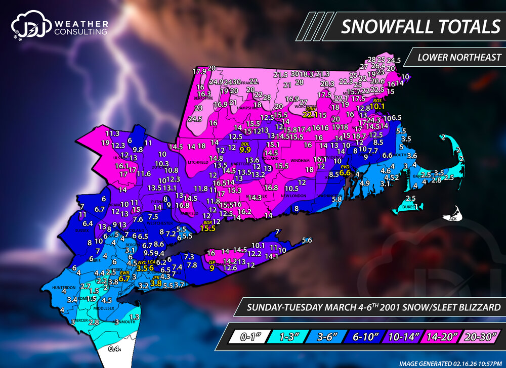
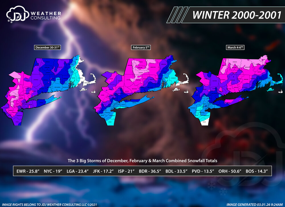
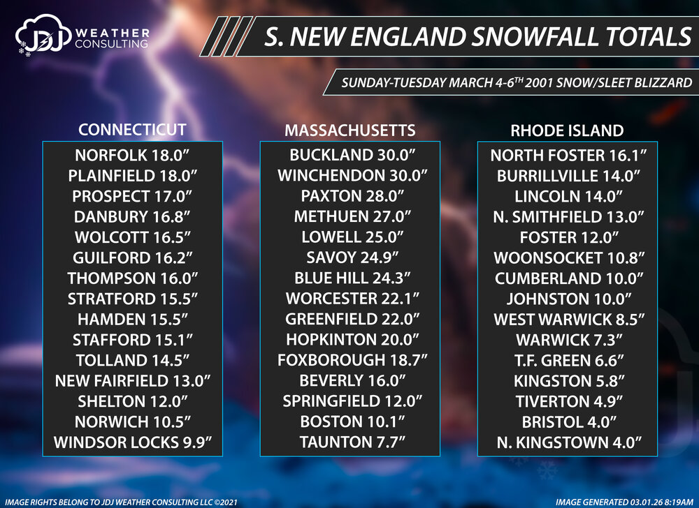
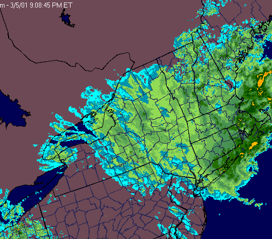
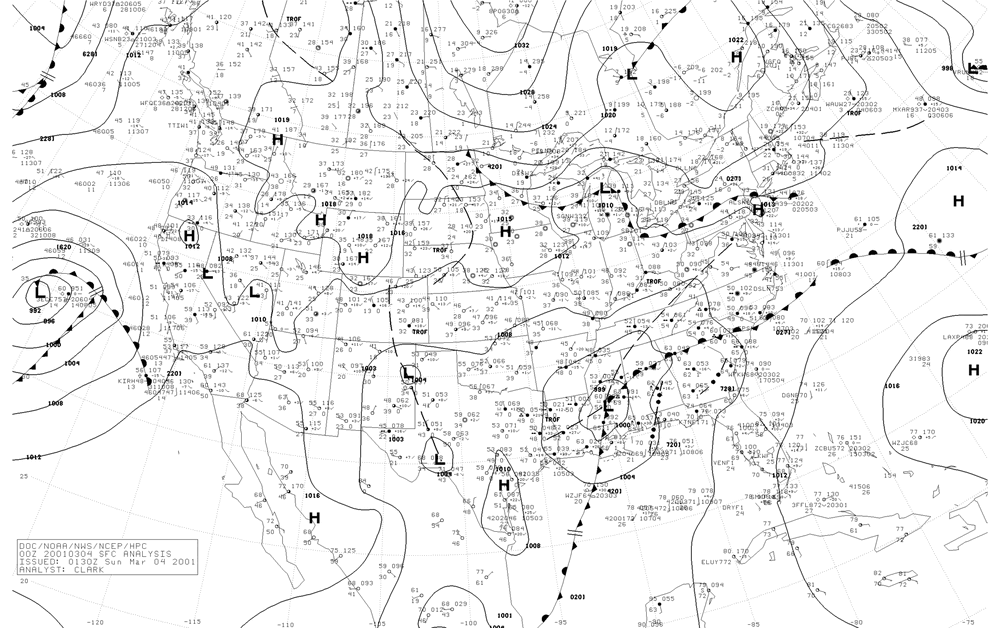
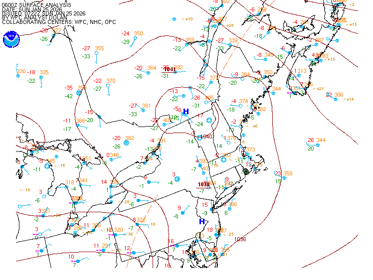
It's the 25th anniversary of the infamous March 4-6th, 2001 Blizzard. I've remapped this event now for about the 5th or 6th time and feel I've gotten as close to approximating what happened as i can get and included a new L. Northeast map. As this is a special historic event i also put together a couple of additional graphics, a town by town snowfall list and all 3 of the big storms of Winter 2000-2001. Mar 2001, Feb 2001 and Dec 2000 are the three big storms that really got me into weather at a young age and love for the extreme snowstorms and especially thundersnow. JDJ March 4-6th, 2001 Page - Our snowfall maps, full radar and surface map animations and additional images PolarWX Reanalysis - Tomer Burg's site with a reanalysis of the storm from the ECMWF Weathernet6 Archive - Steve LaPointe's Archive (scroll down and click on March 4-6th, 2001 on the left hand panel) Ray's Winter Storm Archive - Ray's March 4-6th, 2001 dedicated page Personal Recounting The first memory i have about this storm was turning on the local news on Friday night and hearing a teaser about "a storm we could be measuring in feet". All weekend i was flipping back and forth between TWC and local news stations. I remember seeing Kocin on air at the time talking about it could be the biggest snowstorm in NYC in 50 years (probably referring to 1947). When Sunday morning came the whole state and pretty much the east coast, was shut down and preparing for the incoming storm. Light snow broke out in the mid morning hours and continued throughout the day. By dark we had a couple inches on the ground and here came the sleet. It was nothing but a pelting all night long and into the day on Tuesday. At this point it could have been a massive bust but the storm really blew up and the radar filled in and heavy snow backed in from the east/southeast. A full blown blizzard was occuring during the evening and into the overnight hours. We were out snowmobiling up and down the streets with plows unable to keep up and most likely focused on the highways and main roads. By morning on Tuesday, a couple inches of snow & sleet mix turned into over a foot of new snow with light to moderate snow still falling. Throughout the day Tuesday snow continued to fall and seemed like it would never end, over 48 hours later. Snow finally came to an end around midnight, Wednesday about 64-65 hours after it had started. This one of the few surviving radar stills from WeatherTap on March 5th at 9PM. The file size is way too big to attach here, you can click on the link to my page above if you want to see the full radar loop. Here is also a sfc map gif i put together. Snowfall Maps This was probably the most brutal storm to ever put together with widely varying snowfall totals and incomplete PNS reports. The BOX PNS is terrible but it at least has dates and times next to the reports so its easy to see the ones that aren't final. The OKX PNS is even worse. The official snowfall totals at climate sites are almost certainly wrong at many sites. The BDR official is 15.5 which seems reasonable until you see some of the reports nearby that are a lot lower. BDL is almost certainly wrong and too low. ORH, according to Will, stopped reporting so its probably slightly too low, and so on. I put together a town by town list of some selected reports and all 3 big storms and snowfall totals combined. And of course the best video on the internet
-
RGEM/GEM remain the warmest but are slowly caving colder a bit.
-
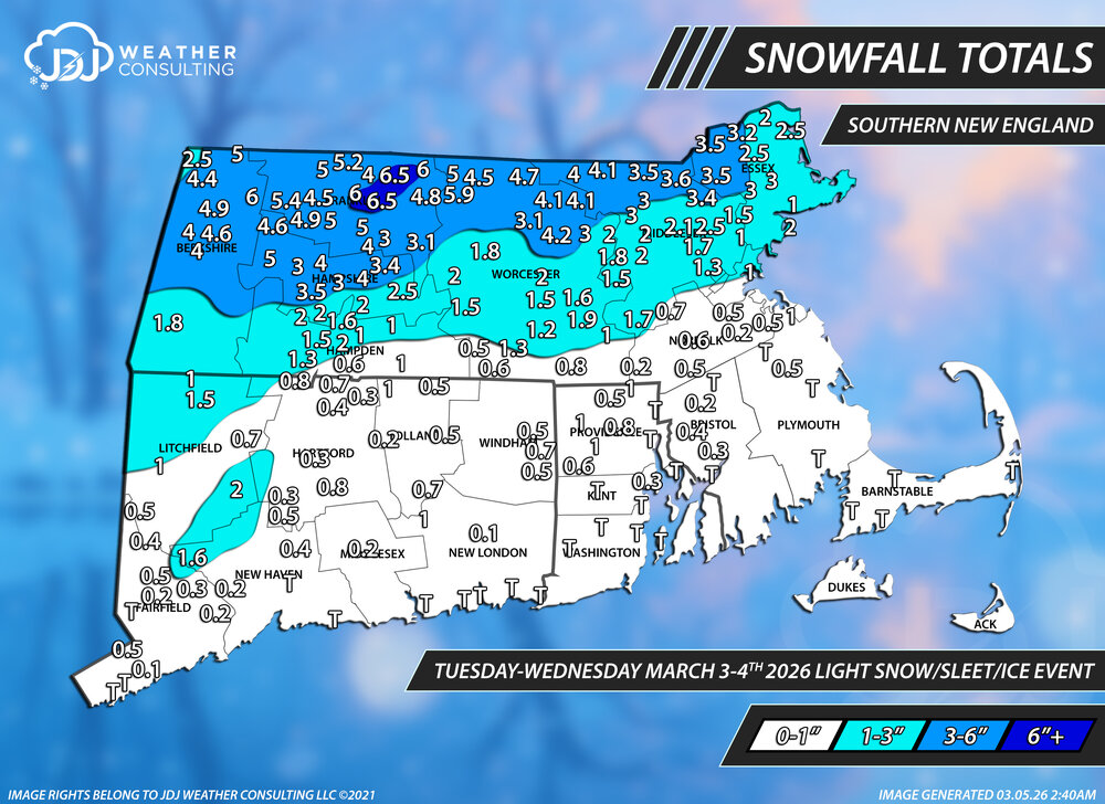
Snowfall Totals for this kitchen sink event
-
It was great here but disappointing at the same time seeing areas in every direction get crushed with 20-30". But i can't be mad at a 17" snowstorm...that's still major in my book and probably on par with biggest ive seen. One day ill get to see what a 20+ or two foot storm looks like... Definitely the worst blizzard conditions ive ever seen by far. Still catching up on past maps from Feb 20, Feb 25, Mar 1, Mar 3-4 which will be done shortly.
-
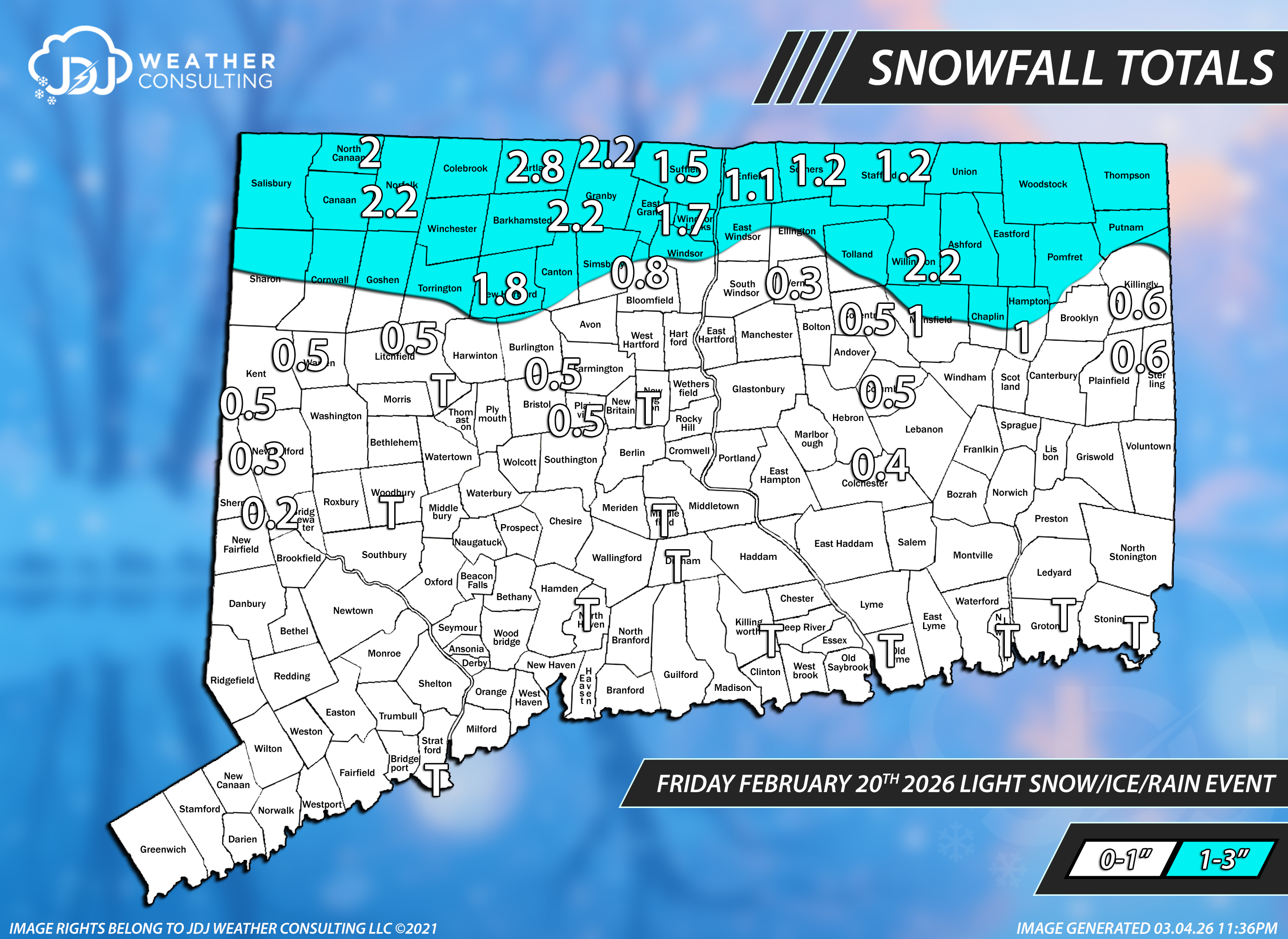
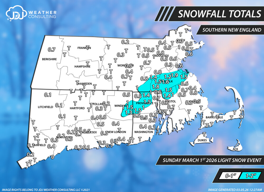
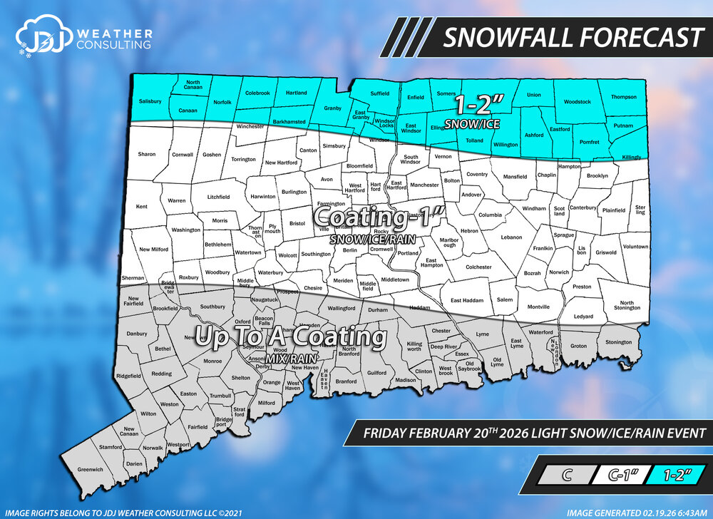
Snowfall totals from this light snow event. Went C-2 statewide, probably could have easily done C-1 and it would have been better with just a couple reports around Killingly area over 1".
-
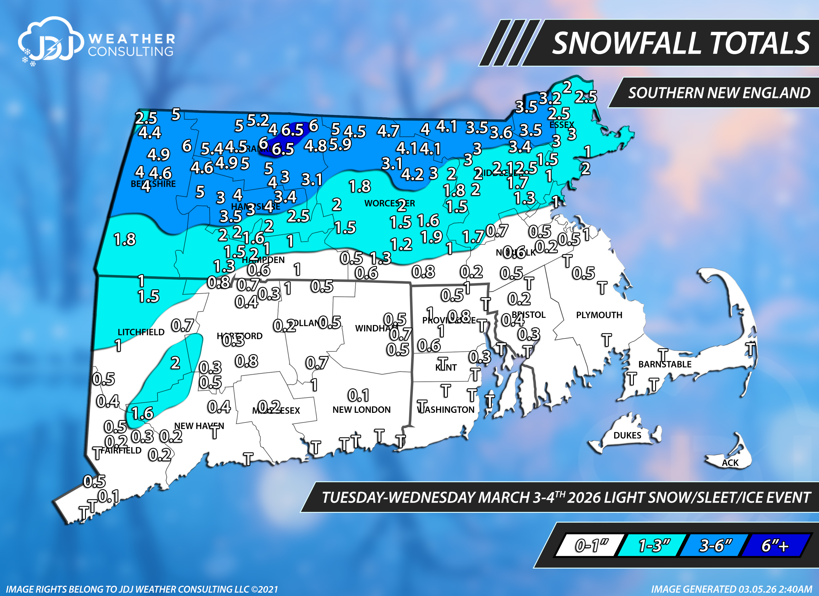
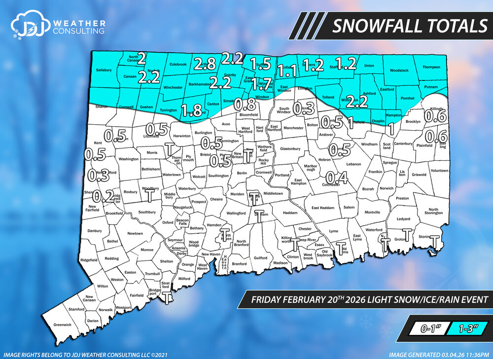
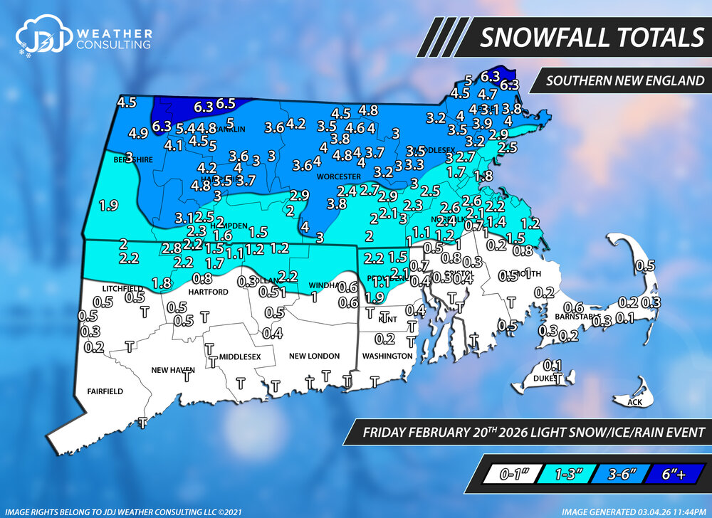
Working my way backward, finally finished this slop event. It's been hard to keep up with all these C-3 type events. Forecast for this was pretty much excellent for CT. A- Oh and the BOX PNS is pretty hilarious. TWO ORH reports included and both of them are wrong . The final for ORH was 2.4
-
you want snow all of a sudden?
-
I haven't looked at this closely at all but from what ive seen it doesn't seem conservative at all to me, if anything its bullish on the snow. I dont see this producing any accumulating snow south of 90 Not saying this NWS map is right or what id go with, just compared to what little ive looked at this and whats out there its on the higher end snowfall wise.
-
I'd still like to know when, if ever, Jan 25-26th is coming. There are some pretty puny Cat 1s in that list so i have no doubt its obviously higher than a Cat 1. Has to be at least 2 or 3. I dont know if theyll ever do it, if they skipped right over to Feb Thats a large area of 8-18 over major US cities
-
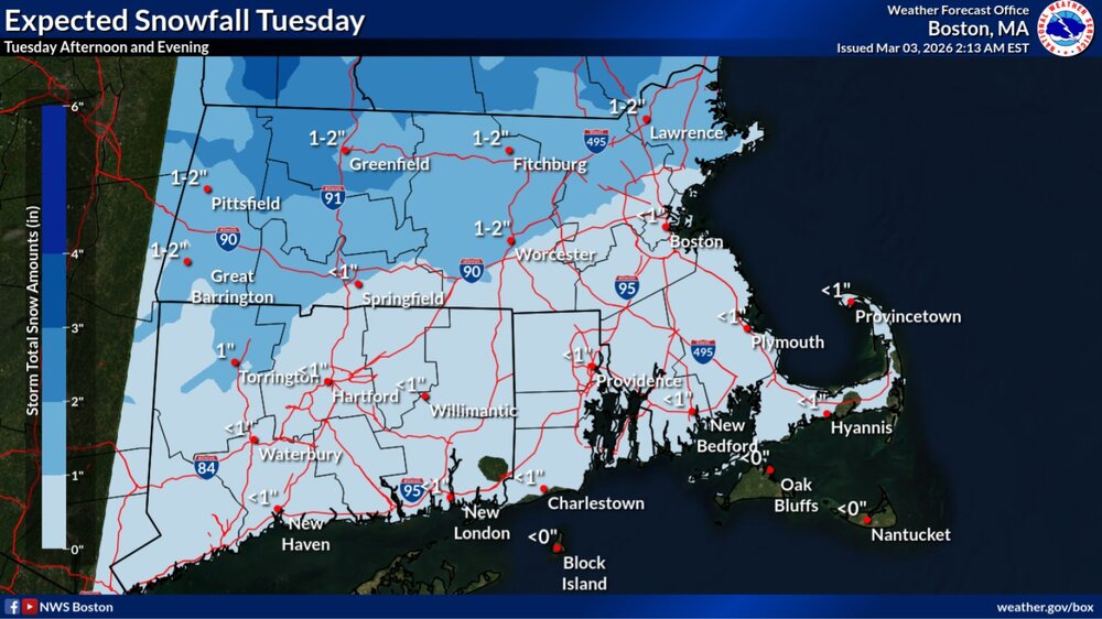
March 4-6th, 2001 incoming
-
2025-2026 New England Snow Recordkeeping Thread
The 4 Seasons replied to bristolri_wx's topic in New England
yeah but where? You got a link? I'd like to include it i have the cocorahs Foster 4.0SSE but that's not the same station i think you said N Foster was at 79.9 or something close to that -
any accumulating snow better stay N of the MA boarder, i dont have time for this nonsense still working on catching up on Mar 1 and Mar 3
-
2025-2026 New England Snow Recordkeeping Thread
The 4 Seasons replied to bristolri_wx's topic in New England
and where did you see N Foster COOP? they stopped reporting to the sites i use xmACIS2 and Climod2 in 2025, so i got nothing from them all season. -
I asked about this before I included it and Will or Scott said they were in the meat of that band for the longest even more so than Warwick that picked up 37.9. I looked at the radar back many times and it definitely feels plausible and that was depth not 6 hrly. I know it wasn't in the pns maybe they didn't send it to BOX or tag them or they just left it out. Either way I think it's within reason.
-
2025-2026 New England Snow Recordkeeping Thread
The 4 Seasons replied to bristolri_wx's topic in New England
Gonna have to leave it until the final update in April -
yeah thats intentional because the font for the climate sites i.e. PVD 37.9 overlaps with surrounding reports, same thing with all the other climate sites youll notice. So i delete them so it doesnt look bad and become hard to read/see.
-
except for maybe ACK. No reports from there but im estimating 24-36" there I never realized how bad of an area the 91 CTRV in central Hampden and Hampshire counties were until i started putting together these maps and seasonal snowfall stuff. They are just in the worst possible spot, shadowed by the ORH and Berkshire hills, too far north and miss a lot of coastals and E MA specials, too low elevation to do well in those type of events. It's almost better to be in central CT and around Windsor Locks area than up there.
-
That's a serious signal on the AIFS. It's in clown range but man that would be sweet.
-
I still think it's a "coastal" mighta been a weak one but that pressure delta was pretty extreme regardless of the weak SLP. Just wasn't your classic wound up nor'easter. It was similar to PD2 in that way. Blizzard criteria not reached but still plenty windy with gusts over 30-40mph, in the evening and night. That's probably the best storm we've had in the past 10 years around here, probably a top 3 or 2 for me, ever. I dont think i've seen S+ at around 5-7F all day and probably will never see that again. Truly remarkable. Two foot+ storms in one season is always a big W and something that doesnt happen often either.
-
2/24 - 2/25 Clipper Obs (1 - 2" for many on forum)
The 4 Seasons replied to Northof78's topic in New York City Metro
thank you! a little late but i appreciate you letting me know. 0.6 fits in as expected -
2/24 - 2/25 Clipper Obs (1 - 2" for many on forum)
The 4 Seasons replied to Northof78's topic in New York City Metro
This event is now up on the archive as the 12th 3"+ of the season with radar/sfc/upper air maps https://www.jdjweatherconsulting.com/feb-25-2026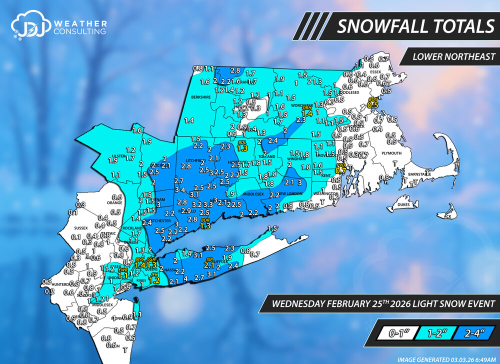
-
Clipper Fires In Wednesday Feb 25 Disco/ Obs
The 4 Seasons replied to Damage In Tolland's topic in New England
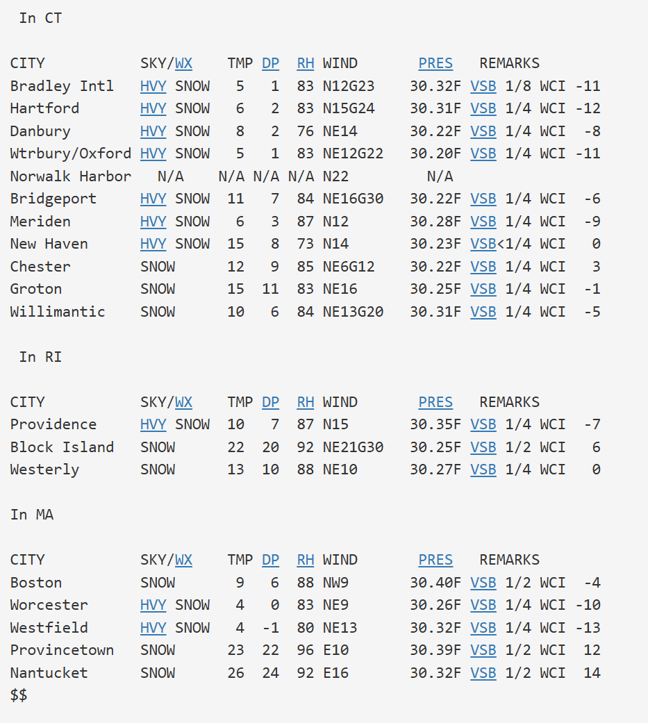
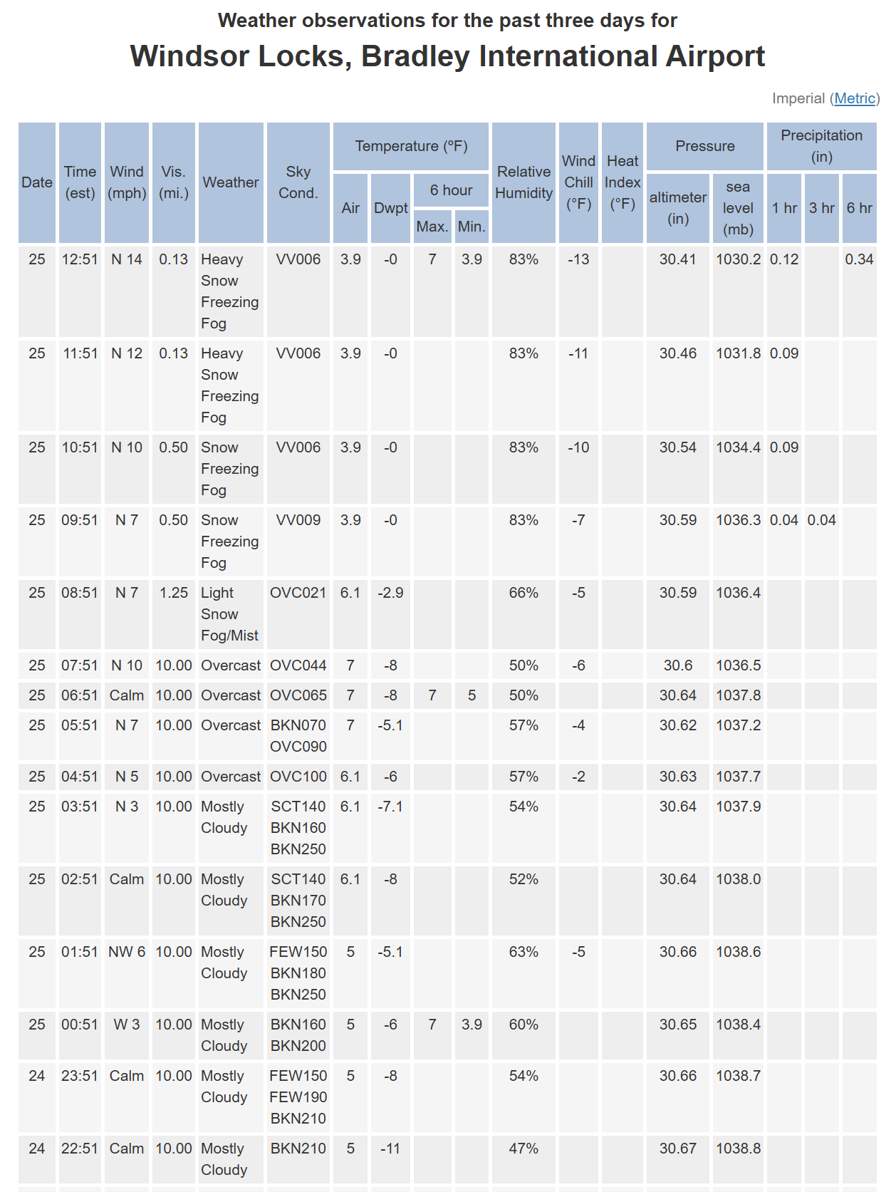
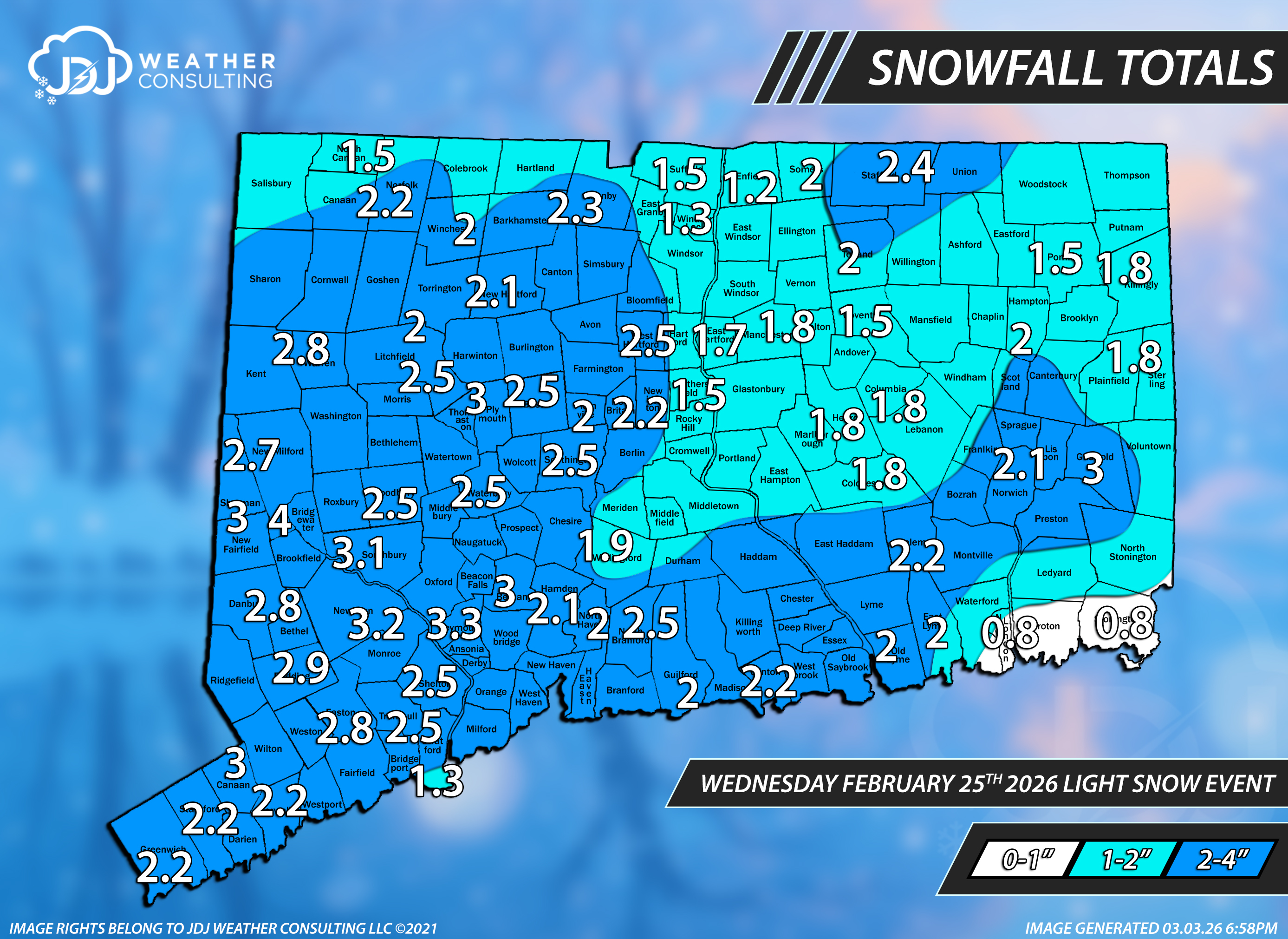
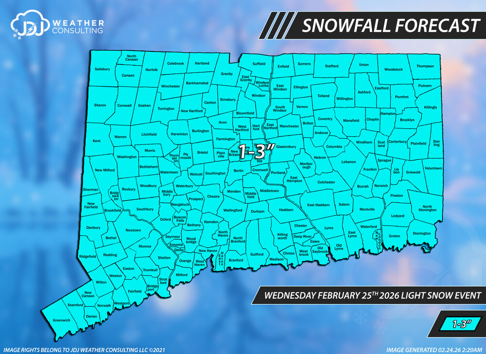
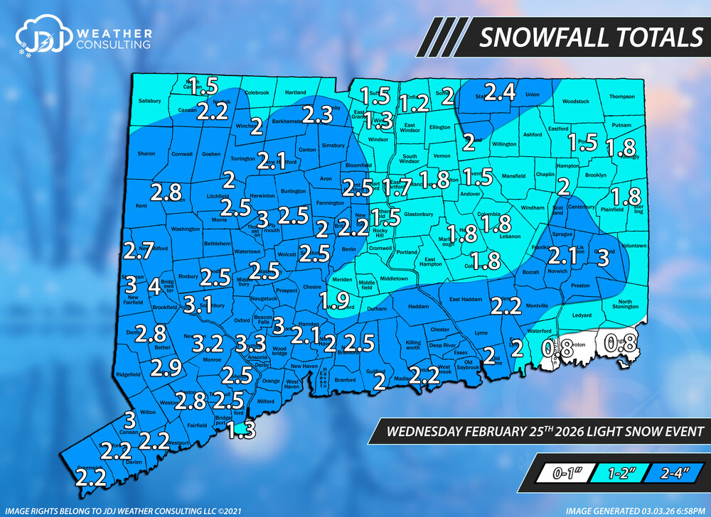
This storm is now up as the 12th 3"+ event of the season with snowfall maps, radar, sfc/upper air maps https://www.jdjweatherconsulting.com/feb-25-2026 We only did a CT map for this but 1-3" worked out nearly perfectly with just a few reports slightly over and a couple slightly under in far SE New London County. The ranges are changed to factor in the entire region. Grade A-
-
yikes