Lookout
-
Posts
5,769 -
Joined
Content Type
Profiles
Blogs
Forums
American Weather
Media Demo
Store
Gallery
Everything posted by Lookout
-
I'm in gatlinburg...light dusting so far (which has mostly melted except on hill tops) with just flurries currently. Mrx is Forecasting 4 to 6 (although last night mrx had 8 to 10).
-
Top gust was 41 but im a bit protected from South winds. Didn't lose power thankfully but over a million out of power in ga at its peak was impressive. Winds are almost as gusty now as this morning. Gusting several times to 35/36. Jackson County Airport gust to 48mph last observation. In fact outages have gone back up in ga the past few hours. So not out of the woods.
-
Pretty wild to see ts warnings so far inland with a gulf hurricane.....making landfall in LA no less . This is really a unique event given its hyper forward speed...and Winds just off the surface are impressive on models..especially wrf/hmon. Going to be really interesting to see how the still strong circulation interacts with the high topography over north ga and the upstate. The ridge tops from your area down to Rome could see some really high winds. Although some of the stronger winds aloft move overhead here, the lack of convection probably keeps most of the gusts in check here. In fact, Looks like it could be a real screwjob rain wise where im at. Zeta almost a cat 3.....110 at 4pm advisory with radar out of New Orleans showing 135mph winds and recon has 113 knot. LA just can't catch a break.
-
45 this morning here. Considering how hot we normally are this time of year you cant ask for much more.
-
Yeah it's hard to get a lot when you start off in the low to mid 40s and daytime too boot. If it had started at night, it probably would have been a different story. The lack of low dewpoints hurt too. I would imagine there aren't too many examples of big snows where temps start in the low to mid 40s with dewpoints only in the 30s upon arrival of precip in ga and sc. Still there should be some accumulations before it's over. Getting any snow at all given how warm this winter has been should be considered a big victory.
-
It's got to be close in the upstate. this station near paris mountain is only 800 feet or so higher than greenville and it's 31. Name:ETV Greenville Valid:20 Feb 2:20 PM EST Temp:31 °F0 °C Dew Point:30 °F-1 °C Relh:96 % Wind Speed:16 mph14 kts Wind Dir:ENE75° Gust:22 mph19 kts Wind Chill:20 °F Altimeter:30.08 in
-
I've seen some weird stuff happen up there when you would think it would be a slam dunk. I'm assuming it's because of the low level warmth sort of being blocked from being scoured out even with a ne flow because of the mountains and the cooling is purely precip driven. Indeed you can see the stubborn low level warmth on the 925 to 975mb levels..which are actually colder to the south and east as the day goes on. A lot just plain heavy rain here currently. I would expect i might get some to mix in by 4pm as the low levels cool even more with ne flow with an ok chance of a full turnover by 0z before ending...unless that band in sc is able to hold on longer and/or this band of heavy precip cools that mid level warm nose a little faster than expected. Don't expect any accumulation since it won't last long even if it does happen but i hope i at least see a little fall.
-
If anyone needs a reminder about not throwing in the towel too early...look at today's rain across ga..been raining all morning here when Most of the models had very little or none at all here in the past 72 hours. Indeed go back and see how poorly the models handled today's rain over the past few days. Cold air supply might be lacking for some but i sure wouldn't get get too discouraged over precip amounts this early for Thursday. Feel like for those in nc stand a good chance...soundings show a cold profile with a really shallow surface warm layer on most guidance that probably would be overcome with decent precip. Upstate might see a changeover at some point but Think this is probably a classic case of the mountains screwing ga by blocking caa. Not buying the Canadian showing precip into friday.
-
That's what I kept thinking to myself last week....that It was really nice to finally have something to track. Was a lot of fun...if there was one negative, it was such a quick shot...hopefully this would last longer. I sure didnt expect to have something to track again so soon...just hope it doesnt shift away or disappear altogether. Even if it shifts north or south, I hope it's a good one so the south can blow out the mid Atlantic this year
-
Yep, if you buy the soundings on the gfs it still looks very similar to Saturday's snow...if not even a touch colder where I'm at...similar to the earlier euro runs. Wish it wasn't still 6 days out and I could cash out now with the 18z gfs...0.70 to 1.00 liquid here..looks like all snow...save for maybe a little rain to start. It's hard not to be hopeful and encouraged but knowing how wrong the gfs normally is at this range..it worries me just as much.
-
Yep, only a very shallow warm layer near the surface which would easily be overcome taking it at face value. It actually is a few degrees colder at 925mb to the surface than Saturday's system. Euro showing 0.50 to 0.75 liquid so those snow total maps are a bit underdone...probably closer to 4 to 6.
-
Just for fun given the time range but Soundings are fine from what I see. Its surface temps are obviously too warm given the snowfall. Keep in mind the euro busted pretty bad with the weekend snow...ended up being 5 to 8 degrees too warm at the surface.
-
If I recall correctly they didnt show any of the weekend snow either until shortly before. We have a long ways to go but hopefully it works out. Have to believe this will be most folks last chance. Considering how rare it is for the gfs to even be close to right on anything at this range, much less snow chances this is probably true.
-
It's been Pretty ridiculous. Already have 0.30 with this first band...and based on upstream totals more than inch seems likely tonight. Which isnt huge news if not for the fact that most of the guidance was further north. Hrrr had my location getting less than 0.10 tonight. Not a good few days for the hrrr.
-
You are in a good spot...probably one of the best outside the mountains as it seems the only question with your location is how much precip falls...as temps at the surface and aloft are plenty cold. Given the early start time where you are you should be at or below freezing for a good portion if it. I would think 1 to 2 inches is a good bet. If anyone outside the mountains do well it will be cumming, Gainesville, dawsonville, etc.
-
Yep..its weird honestly how that is usually the case. Models insist most of it is just north of here but I think its mostly snow as far south as here per soundings...assuming it doesnt arrive too late where surface temps are a problem. Hrrr as usual is too warm at the surface if there is as much precip as advertised. . Regardless it's close enough to drive too regardless. High resolution models showing some pretty decent returns on composite imagery some decent rates arent out of the question. Other than the mountains atlanta to Gainesville could be the winner as it arrives early enough for temps to be near freezing. Could just the nam naming us but the 12z 12 and 3km run showing up to 0.30 liquid now.
-
Looks like some sleet and even snow fell for a brief period at the start in parts of west ga with the heaviest stuff...from around Carrollton to the north. As expected though it's been brief with a quick changeover to rain. The way this year is going they should consider themselves lucky.
-
Well tried as hard as I could to see flakes this morning but alas only managed virga. Its beyond sad and embarrassing that winter sucks so much that it I have to resort to that. I guess the next sad excuse/fail for winter weather.... is there could be a little sleet at the start of precip thur evening due to dry low to mid levels before our exciting mid to upper 30s rain slams us.
-
Something to keep an eye on is maybe some light snow over north ga tonight..hrrr is showing some. (In fact up to an inch or more in the mountains over toward rome). Nav also has been consistent with a little. Despite the dry profiles and runs of everything else, still wouldn't surprise me to see some meso effects create a small area of flurries/showers into tomorrow morning. Not a huge chance but better than zero which is a lot considering how horrible this winter has been.
-
Even though the worst of the storms just missed here, still got hit pretty hard with 40 mph gusts and about 0.35 of rain in a few minutes time. Wasn't as strong as the other day but happening at night makes it seem worse. Considering the daytime heating being added to the mix as opposed to getting hit at 2 in the morning, would expect it could get quite breezy with some of these. I always worry about storms coming in from the north or northwest here since there is a lot of open space in that direction which allows the wind to get quite high.
-
Just got the power back on after getting blasted. Number of trees down or damaged around the area after easily 50 to 60 mph winds and white out conditions. Was a bit nerve racking for a while. Not surprisingly ffc didnt issue a warning when it damn well should have...meanwhile gsp was on the ball as usual and smartly issued a warning for elbert county. Picked up another inch of rain.
-
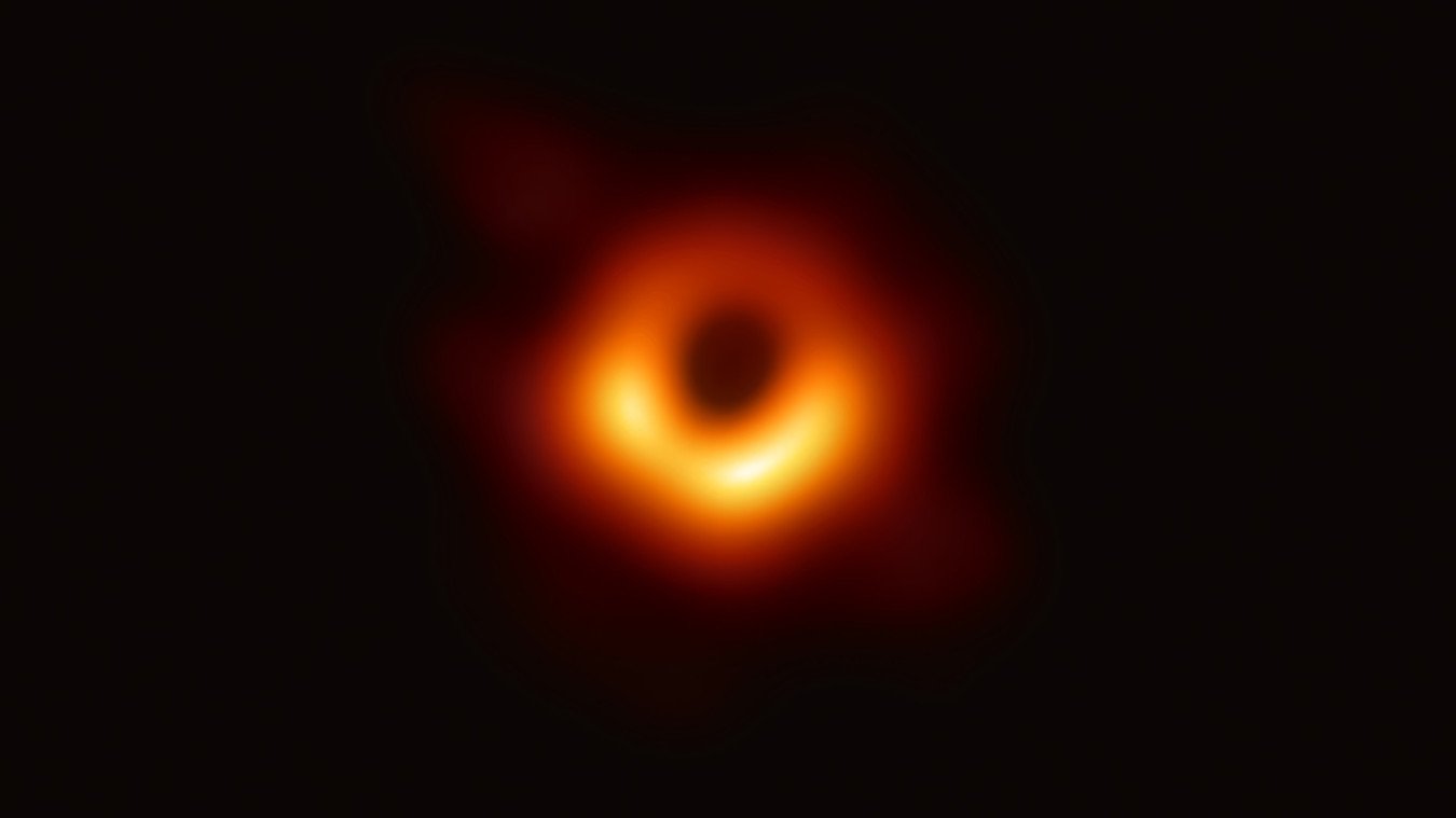
As a fan of cosmology/astronomy since I was a kid, this is about as cool as it gets. First pic of a black hole.

-
Was going to post this,...it's absolutely crazy to see snow down to 6200 feet there.
-
Fascinating. Never ceases to amaze me how the topography effects things around there/here. Sure makes it difficult to get a grasp on what to expect. I've often thought how nice it must be to be in the ohio valley or plains where it's a lot more straight forward. new hrrr is looking really promising, especially for south carollna where they got nothing. a bit colder and dropping a couple of tenths liquid With temps at 32/33.
-
Yeah that sucks. How do you normally do when wedges break down? Do you warm up faster or slower than gsp/anderson? Temp here has actually dropped back to 34 after getting to 35. Still have a 10mph or so ne wind with heavy mist/drizzle. Hard to see me rising 4 or 5 degrees overnight.