Chinook
-
Posts
10,935 -
Joined
-
Last visited
Content Type
Profiles
Blogs
Forums
American Weather
Media Demo
Store
Gallery
Everything posted by Chinook
-
My place had thunder at 1:00, with moderate rain.
-
I guess it can't be 70 every day when there's 1"-2" of rain... or snow
-
this is a range-height cross section of a large hailstorm (supercell) in Mississippi last night. There is an overhang of the huge reflectivity, indicating a large updraft, since it was a supercell. I am doing this because I re-downloaded the GRLevel2AE 21-day trial. (again) and I might as well post something from the 3D capabilities. (I probably won't pay for GRLevel2AE)
-
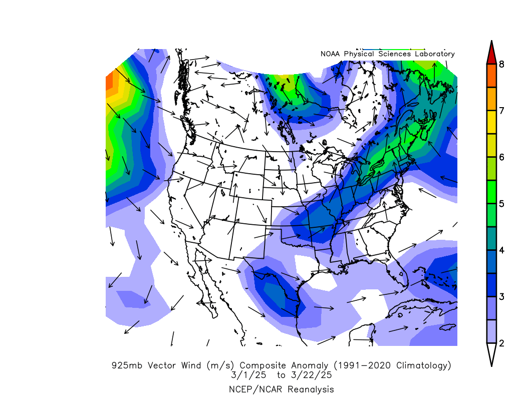
It has been windier than average, near me. This reanalysis plot shows that the 925mb wind was 4m/s (8 knots) higher than average. The 925mb winds usually mix to the surface in the daytime/afternoon, so that's a good indicator that the surface wind has been 4-8 knots above average. I don't know if any particular data-system uses the NWS monthly climate-F6 data to find out abnormal wind speeds. (I've never heard of a calculation like that.)

-
"It's really beautiful around sunset. The methane emissions really pick up the colors." -- Jim Carrey, The Mask.
-
The Dust Bowl coincided with too many La Nina/neutral winters, By my inexact calculations, a double El Nino helped finally wetten up the central part of the country before WWII. And then of course they changed the farming practices and planted trees for windbreaks. By the way, the last storm (March 20th) picked up dirt from the Plains and deposited it on my car through the light rain.
-
This is the first time since 1997 that two F-4/EF-4 tornadoes were in Arkansas on the same day.
-
so, any real tornadoes near Flossmoor/Chicago Heights or east of them?
-
near Charleston/Oakland IL
-
-
heavy snow recently in Wyoming, and other places out west
-
tried to get another BWER on radar by the possible Oakland Illinois tornado
-
My attempt to cut through the storm near the tornado(es)/gustnado(es)
-
the BWER "hole in the storm"
-
storm chasers see tornado at Mackinaw, Illinois
-
it is a tornado warning near Deevlan, just after this
-
this might be the next tornado warning at Delevan, Illinois
-
888 toll-free phone number 211- community assistance phone number tornadoes/warnings
-
multiple tornado warnings
-
there were a lot of local storm reports (48hrs total reports)
-
when there's a 110-kt contour on the shear, and you have convection
-
dual tornado warnings
-
-
large tornado on the ground
-
Dayton already had a wind gust of 53 kt (61mph) and this storm went right next to Louisville with several severe reports. New tornado warning in N Mississippi (Holly Springs)