PackGrad05
-
Posts
1,974 -
Joined
-
Last visited
Content Type
Profiles
Blogs
Forums
American Weather
Media Demo
Store
Gallery
Everything posted by PackGrad05
-

Mid to Long Range Discussion ~ 2022
PackGrad05 replied to buckeyefan1's topic in Southeastern States
Antecedent temperatures will be really warm. Ground and road will warm up quick. -
Mid to Long Range Discussion ~ 2022
PackGrad05 replied to buckeyefan1's topic in Southeastern States
Don’t fret too much by looking at long range. Remember the long range showed this being a monster storm for us. Things change. we still have a good amount of time. Yes it does get more difficult but February and even March have produced big ones. -
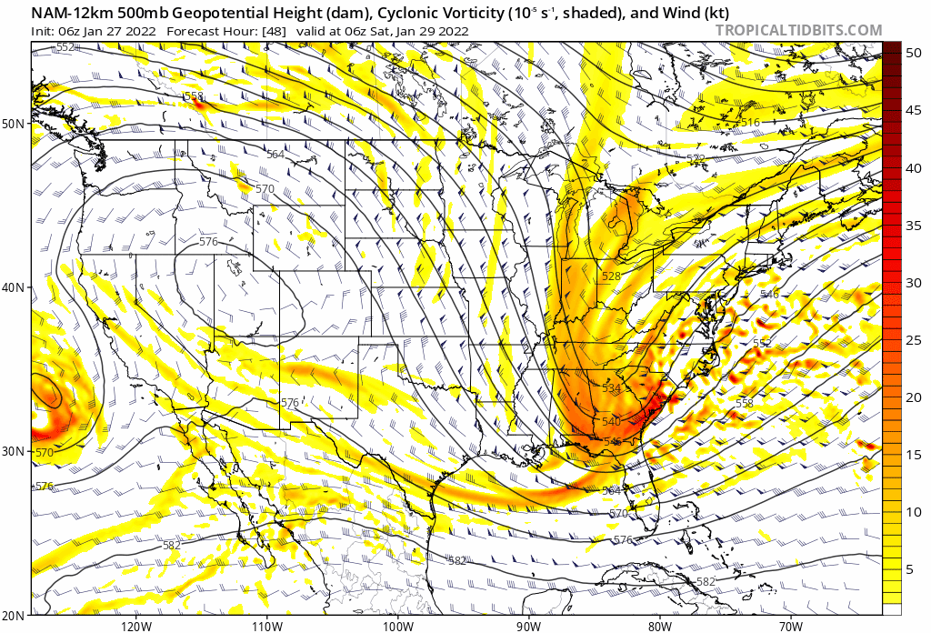
Potential 1/28-1/30 2022 winter storm
PackGrad05 replied to Prismshine Productions's topic in Southeastern States
RAH discussion looks fine to me. I never really expected more than an inch here in southern Wake. We will see what happens. -
Potential 1/28-1/30 2022 winter storm
PackGrad05 replied to Prismshine Productions's topic in Southeastern States
3K NAM looks decent for Wake. Nice 6-8 hour period of light snow, taken verbatim. Granted, boundary layer temps are above freezing at the onset so a lot of it melts on contact... I think an inch on the ground would be a win for Wake. -
Potential 1/28-1/30 2022 winter storm
PackGrad05 replied to Prismshine Productions's topic in Southeastern States
Snow will likely still be falling at the end of that HRRR run. That won't represent storm totals. -
Potential 1/28-1/30 2022 winter storm
PackGrad05 replied to Prismshine Productions's topic in Southeastern States
So it looks like a ~6 hour period of light snow for central NC. -
Potential 1/28-1/30 2022 winter storm
PackGrad05 replied to Prismshine Productions's topic in Southeastern States
I put "bad" and "good" in quotation marks because it is subjective (whether you want snow or don't want snow). I just meant that sometimes we praise the NAM when it shows what we want, but discuss how it is inaccurate when it doesn't show desired outcomes.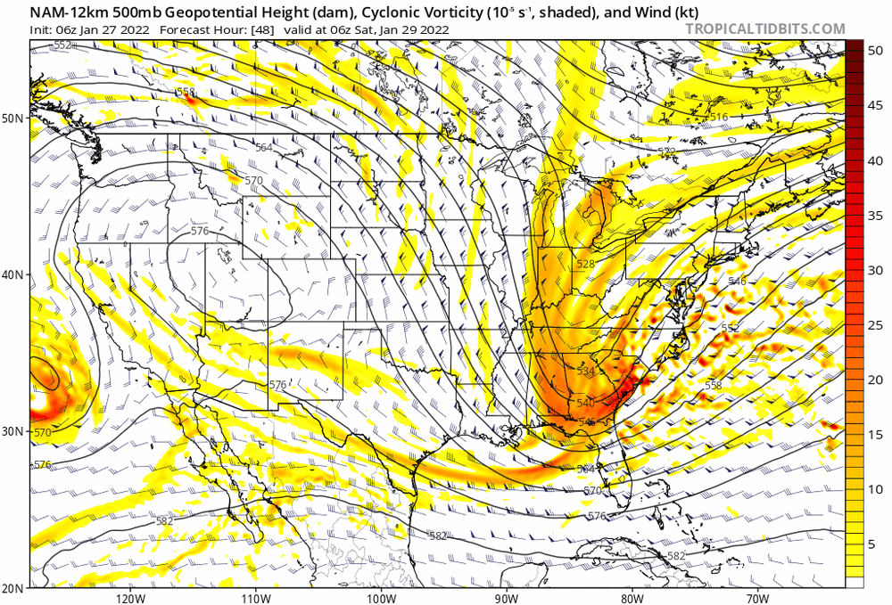
-
Potential 1/28-1/30 2022 winter storm
PackGrad05 replied to Prismshine Productions's topic in Southeastern States
I think the last few weeks has shown that the NAM is not reliable at all. Brad P even mentioned concerns about its reliability over the last few years since they are transitioning to FV3 and HRRR. If you throw out the "bad runs", you also need to throw out the "good" runs. -
Potential 1/28-1/30 2022 winter storm
PackGrad05 replied to Prismshine Productions's topic in Southeastern States
Verbatim it shows 5-6 hours of snow... That's a nice event for our area, even if it is an inch or so. -
Potential 1/28-1/30 2022 winter storm
PackGrad05 replied to Prismshine Productions's topic in Southeastern States
I'm watching it and that band pivots right through central NC. -
Potential 1/28-1/30 2022 winter storm
PackGrad05 replied to Prismshine Productions's topic in Southeastern States
WRAL's first hand-drawn call map for this system. -
Potential 1/28-1/30 2022 winter storm
PackGrad05 replied to Prismshine Productions's topic in Southeastern States
Cue the local mets showing trends decreasing with euro ensemble probabilities. -
Potential 1/28-1/30 2022 winter storm
PackGrad05 replied to Prismshine Productions's topic in Southeastern States
Euro ensembles are what matters. Waiting on those. -
Potential 1/28-1/30 2022 winter storm
PackGrad05 replied to Prismshine Productions's topic in Southeastern States
Remember this is the same time period that many models lost the storm last week only to trend back with better data as the date drew near. -
Potential 1/28-1/30 2022 winter storm
PackGrad05 replied to Prismshine Productions's topic in Southeastern States
EURO has been most consistent with this event. Interested to see what 12Z ensembles show. Other guidance appears to be trending that way. -
Potential 1/28-1/30 2022 winter storm
PackGrad05 replied to Prismshine Productions's topic in Southeastern States
Still plenty of time. Nothing has really changed over the past 2-3 days if you look at the big picture. Still looks like a rain/snow event with light amounts possible over central NC. -
Potential 1/28-1/30 2022 winter storm
PackGrad05 replied to Prismshine Productions's topic in Southeastern States
Euro has been most consistent so far. Less fluctuations. -
Potential 1/28-1/30 2022 winter storm
PackGrad05 replied to Prismshine Productions's topic in Southeastern States
Great article about how ensembles work if anyone is interested. https://www.wral.com/how-wral-meteorologists-use-ensemble-forecasting-to-determine-the-chance-of-1-or-3-snow-in-your-town/20099023/ -
Potential 1/28-1/30 2022 winter storm
PackGrad05 replied to Prismshine Productions's topic in Southeastern States
Latest from local station. I think they have just resorted to posting EURO ensemble probabilities and just update it every 6 hours. -
Potential 1/28-1/30 2022 winter storm
PackGrad05 replied to Prismshine Productions's topic in Southeastern States
The latest update from WRAL. Posting European ensembles again. https://twitter.com/mazewx66/status/1486087212534050817?s=21 -
Potential 1/28-1/30 2022 winter storm
PackGrad05 replied to Prismshine Productions's topic in Southeastern States
Euro ensembles will be a better gauge. -
Potential 1/28-1/30 2022 winter storm
PackGrad05 replied to Prismshine Productions's topic in Southeastern States
From Mike Maze: Many folks have been reaching out about the possibility of a major winter storm this weekend. Today's model runs are not showing it at all. Here's a look at the European Ensemble probabilities for 1" of snow ending Saturday night. Does not look good to me right now. Ensemble map shows 26% chance of 1" of snow for Wake. -
Mid to Long Range Discussion ~ 2022
PackGrad05 replied to buckeyefan1's topic in Southeastern States
Starts as rain and then changes to snow as it gets cranking. -
Mid to Long Range Discussion ~ 2022
PackGrad05 replied to buckeyefan1's topic in Southeastern States
Yes, they did say that. It was on their blogs. I haven't verified the accuracy of the statement though. As for next weekend, the signal is there, but cold air looks limited for now. -
Mid to Long Range Discussion ~ 2022
PackGrad05 replied to buckeyefan1's topic in Southeastern States
the local mets said that the EURO was most consistent with this weekend's storm from day one..