PackGrad05
-
Posts
1,974 -
Joined
-
Last visited
Content Type
Profiles
Blogs
Forums
American Weather
Media Demo
Store
Gallery
Everything posted by PackGrad05
-

Mid to Long Range Discussion ~ 2023
PackGrad05 replied to buckeyefan1's topic in Southeastern States
Need a stronger high to move that further to central NC. -
Mid to Long Range Discussion ~ 2023
PackGrad05 replied to buckeyefan1's topic in Southeastern States
HRRR wants to pop some convective cells after dark...primarily east of 95 but Wake and central NC should keep an eye on it also. -
Mid to Long Range Discussion ~ 2023
PackGrad05 replied to buckeyefan1's topic in Southeastern States
GFS has been east of other guidance for a few runs now. -
Mid to Long Range Discussion ~ 2023
PackGrad05 replied to buckeyefan1's topic in Southeastern States
Latest run of what? -
Mid to Long Range Discussion ~ 2023
PackGrad05 replied to buckeyefan1's topic in Southeastern States
Central NC would be rain. The track is too far inland. Western NC would be sitting pretty. Latest HRRR shows 2-3" widespread for central NC. Also shows the deformation band pivoting through Monday morning. Winds have died down which is a good thing. -
Mid to Long Range Discussion ~ 2023
PackGrad05 replied to buckeyefan1's topic in Southeastern States
By "well inland", do you mean west of 95? The latest Euro and GFS still show a good dose of rain for central NC (2-3 inches) and gusty winds. -
Mid to Long Range Discussion ~ 2023
PackGrad05 replied to buckeyefan1's topic in Southeastern States
Sustained cold is nice, but it really only takes a good shot of cold air to time up right with some moisture. That's about as good as you can ask for around here. That anomaly map isn't that dire. 4-6 degrees above average this time of year is highs in mid-to-upper 50s. With lows in 30s and 40s at night that's fine by me. Far from a torch. -
Mid to Long Range Discussion ~ 2023
PackGrad05 replied to buckeyefan1's topic in Southeastern States
Besides this saturday/sunday, the next 10-15 days look below normal. We always focus on the above normal temps but never give the below normal temps much attention....unless there is something frozen with them. -
Mid to Long Range Discussion ~ 2023
PackGrad05 replied to buckeyefan1's topic in Southeastern States
A long way out but the EPS has had something the last 3 model runs around the 29/30 time period... snow perhaps. -
What's ironic is that it will have more of an impact that then remnants of the one a few weeks ago. The difference it that it doesn't come with all the "hype" that the other one did.
-
The 18Z 3K NAM has gusts of 50-60 over central NC Saturday morning.
-
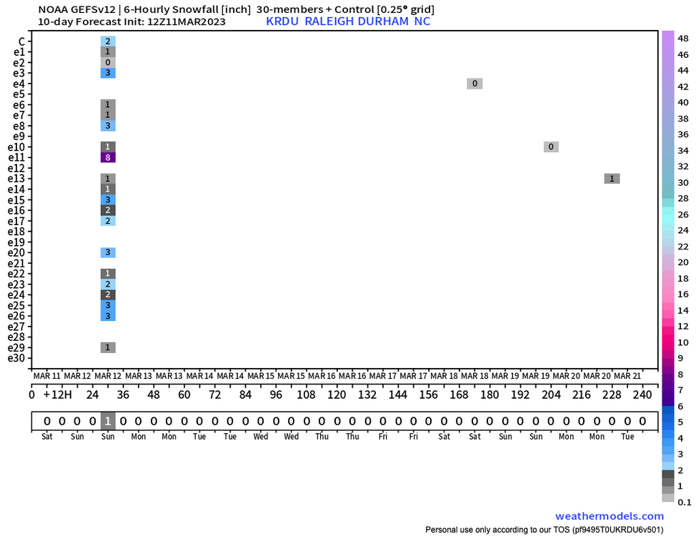
Way more spread than 00Z members. Lots of uncertainty.
-
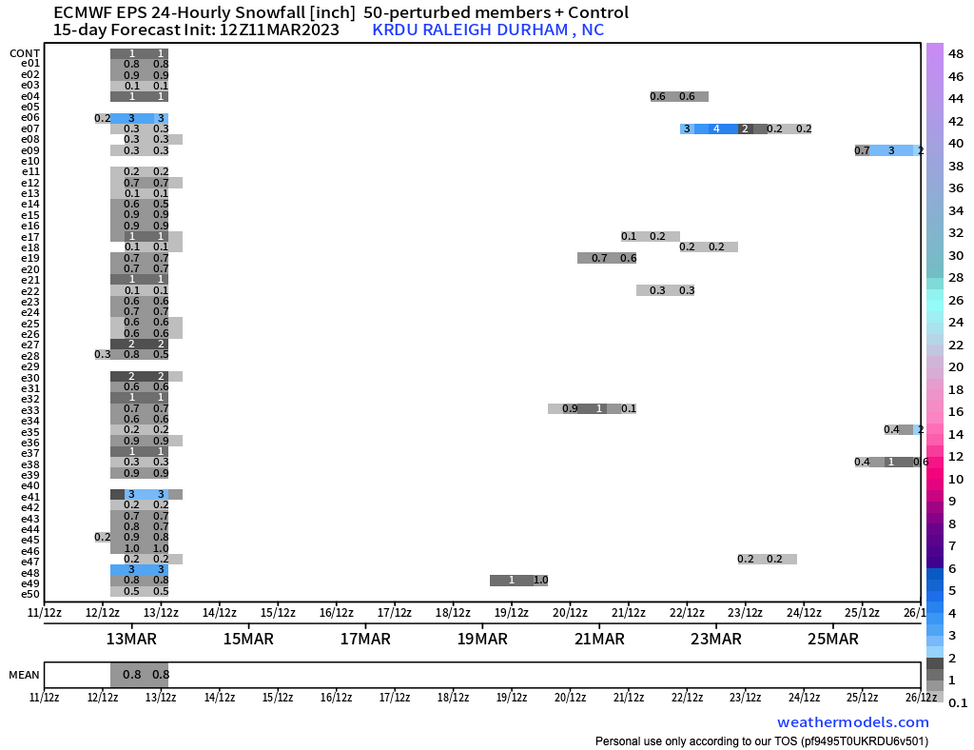
12Z EPS members

-
Idalia to heavily affect large portion of SE
PackGrad05 replied to GaWx's topic in Southeastern States
High res NAM and HRRR are still showing a steady rain from this afternoon all the way to mid-morning. I definitely think the big story will be ponding/localized flooding. Morning commute could be messy. Scattered power outages as always. Big gradient possible across Wake (as always). -
Looking at impacts for NC, particularly central NC. Getting in range of high-res models. NAM 3K is bullish on some heavy rain bands setting up, particularly Thursday morning thru mid-day. Could get pretty gusty as well during those bands. Most of central NC in flood watch now.
-
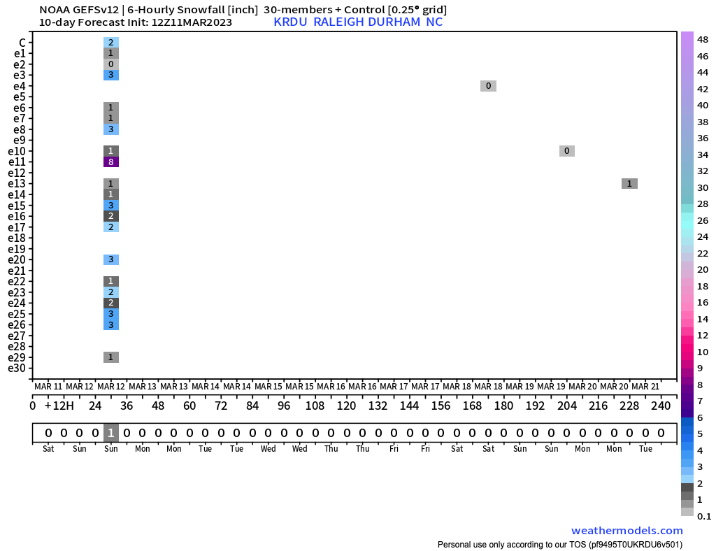
6Z GEFS and EPS are almost identical and tightly packed.
-
With so many consistent moves to the east, a move back west wouldn't be surprising at this point. It's really going to depend on the speed and the trough strength to the north.
-
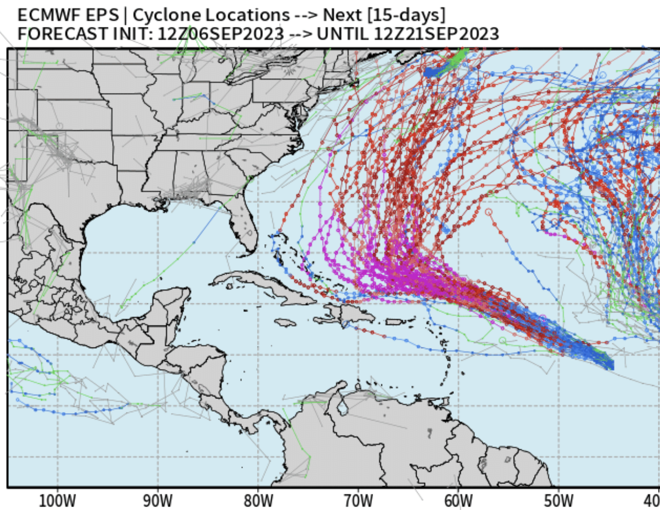
There is still a decent amount of spread in the ensembles (both EPS and GEFS) with regards to impacts on the SE coast. The exact track will determine impacts not only at the coast, but inland.
-
12Z GFS is almost identical to ECMWF and EPS. Rides GA/SC coast and then turns east at Cape Fear out to sea.
-
6Z EPS model consensus is tight around a big bend landfall and then riding the GA/SC/NC coast up to Cape Fear. ECMWF, UKMET, and ICON largely agree. 6Z GEFS model consensus slightly west of this.
-
Mid to Long Range Discussion ~ 2023
PackGrad05 replied to buckeyefan1's topic in Southeastern States
NAM definitely has higher CAPE than GFS and EURO. -
Mid to Long Range Discussion ~ 2023
PackGrad05 replied to buckeyefan1's topic in Southeastern States
Crazy how much the GFS changed. Tons of rain for NC to absolutely nothing. It'll keep wobbling. -
Mid to Long Range Discussion ~ 2023
PackGrad05 replied to buckeyefan1's topic in Southeastern States
Both the GEFS and EPS are trending in the right direction, which is all we can really watch at this time....trends. -
Mid to Long Range Discussion ~ 2023
PackGrad05 replied to buckeyefan1's topic in Southeastern States
Neither of the ensembles (euro or gefs) are on board yet. The 00z ecmwf also shows zilch. . -
Sunday March 12th white rain tracking
PackGrad05 replied to olafminesaw's topic in Southeastern States
The signal on both the EPS and GEFS is honestly the best it has looked this season, especially this close to the event.