PackGrad05
-
Posts
1,974 -
Joined
-
Last visited
Content Type
Profiles
Blogs
Forums
American Weather
Media Demo
Store
Gallery
Everything posted by PackGrad05
-

Mid to Long Range Discussion ~ 2024
PackGrad05 replied to buckeyefan1's topic in Southeastern States
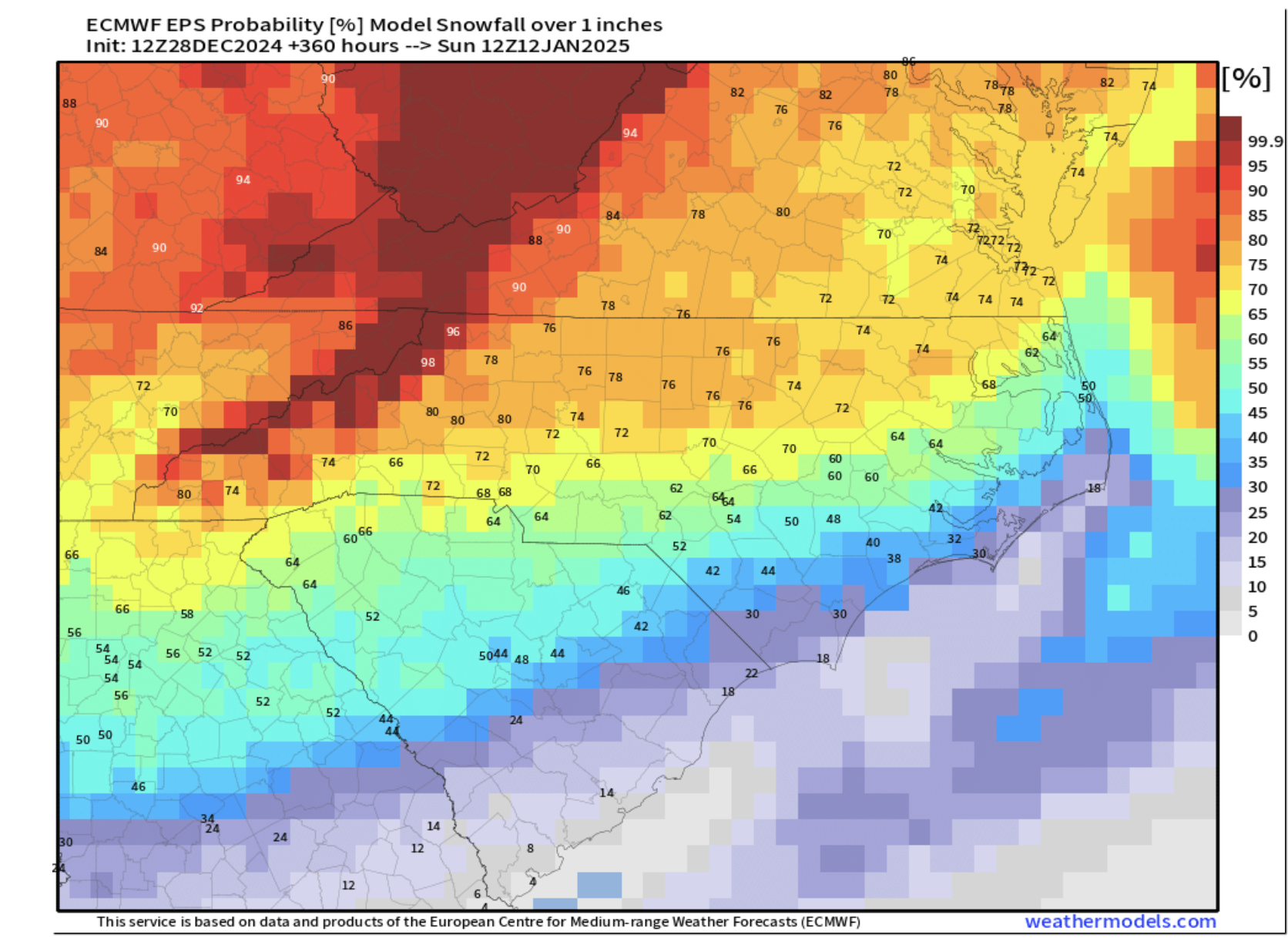
EPS probability of 1" of snow for RDU between now and 1/14 is around 56% GEFS also likes the 1/10-1/14 timeframe but is considerably less than what it was showing yesterday. Trends have not been favorable and, if anything, keep kicking it down the road to later dates. -
Mid to Long Range Discussion ~ 2024
PackGrad05 replied to buckeyefan1's topic in Southeastern States
It has stayed generally the same... 10-day probability of 1" of snow or more is around 15% for RDU. Beyond 10 days, it tops out at 2-4" mean snowfall -
Mid to Long Range Discussion ~ 2024
PackGrad05 replied to buckeyefan1's topic in Southeastern States
Roughly 29/50 EPS members show something (light) around 1/6. Then there is another signal between 1/8-1/11 but they are all over the place as far as timing and amounts. GEFS does not have the 1/6 event... seems to be honing in more on the other one. -
Mid to Long Range Discussion ~ 2024
PackGrad05 replied to buckeyefan1's topic in Southeastern States
12Z Euro shows 3-5" of snow from murphy to manteo on 1/6-1/7 -
Mid to Long Range Discussion ~ 2024
PackGrad05 replied to buckeyefan1's topic in Southeastern States
The 00Z EPS 1" probabilities for RDU actually decreased 20% from the 12Z runs. Went to around 50% from upwards of 70%. -
Mid to Long Range Discussion ~ 2024
PackGrad05 replied to buckeyefan1's topic in Southeastern States
Same model shows a 28% chance of 6" and 10% chance of 12"
-
Mid to Long Range Discussion ~ 2024
PackGrad05 replied to buckeyefan1's topic in Southeastern States
Important to note that the latest Euro ensembles seem to be focusing on two events... one in the 6/7 timeframe and another around the 9/10 timeframe. Both events have a mean of 1-2"... The second event has 7/50 members at 10"+. The majority of members are between 0-2"... -
Mid to Long Range Discussion ~ 2024
PackGrad05 replied to buckeyefan1's topic in Southeastern States
EPS probabilities (00Z 27 Dec) indicate about 33% chance of 1" of snow for RDU...primarily from the 1/9-1/10 system. -
Mid to Long Range Discussion ~ 2024
PackGrad05 replied to buckeyefan1's topic in Southeastern States
EPS shows about a 15% chance of 1" of snow for RDU through that time period. -
Mid to Long Range Discussion ~ 2024
PackGrad05 replied to buckeyefan1's topic in Southeastern States
while the euro op looked good, the ensembles show a 30% chance of dusting and less than 15% chance of 1" (as of now). -
Mid to Long Range Discussion ~ 2024
PackGrad05 replied to buckeyefan1's topic in Southeastern States
Agreed. Snowstorms around here are usually during that short cold period that is surrounded by above normal temperatures... The problem is, we aren't able to cash in on these cold streaks when they come. -
Mid to Long Range Discussion ~ 2024
PackGrad05 replied to buckeyefan1's topic in Southeastern States
12Z EURO looks much cooler. -
Mid to Long Range Discussion ~ 2024
PackGrad05 replied to buckeyefan1's topic in Southeastern States
The EPS and GEFS probabilities for snow for central NC actually increased over the last run....Still low probability, but increased. -
Mid to Long Range Discussion ~ 2024
PackGrad05 replied to buckeyefan1's topic in Southeastern States
December isn't over yet... Can't remember the last time we tracked a storm from 10 days out. I think something will pop up and be a "within 5 day score" if we end up getting anything. Don't need wall to wall cold... just the cold and moisture to link up at the right time. -
Mid to Long Range Discussion ~ 2024
PackGrad05 replied to buckeyefan1's topic in Southeastern States
Way too early to be punting to 2025. -
I hit 32.0 this morning in Willow Springs according to my Tempest. Lasted about 45 minutes.
-
Mid to Long Range Discussion ~ 2024
PackGrad05 replied to buckeyefan1's topic in Southeastern States
I'm in a rural area in southern Wake and haven't come close to 32. 39 is the lowest I've hit so far. Has any station in Wake, or Johnston for that matter, reported freezing temps yet? -
1.36" of rain on Thursday in Willow Springs. Also hit my coldest temp of the month this morning (11/17) which was 39.
-
Mid to Long Range Discussion ~ 2024
PackGrad05 replied to buckeyefan1's topic in Southeastern States
Looking more and more likely that Raleigh breaks record for latest first freeze. November 28 since records were taken at RDU and December 3 prior to RDU. The upcoming trough gets us back to "normal" levels and then another warm-up after that. -
Mid to Long Range Discussion ~ 2024
PackGrad05 replied to buckeyefan1's topic in Southeastern States
RDU looks to break the record for latest date of first freeze. Record is November 28, set in 2009. I don't see it happening before then. -
Mid to Long Range Discussion ~ 2024
PackGrad05 replied to buckeyefan1's topic in Southeastern States
Over the last 50 years, the latest first freeze for RDU is November 28. I don't see anything remotely close to freezing in the next 10-15 days. If the pattern doesn't shift, we could get close to that record. -
Mid to Long Range Discussion ~ 2024
PackGrad05 replied to buckeyefan1's topic in Southeastern States
Over the past 50 years, the average first freeze for RDU is October 30. However, if you restrict it to the last 15 years, the average is almost mid-November. The latest on record is November 28 which was 2009. I don't see anything promising over the next 10 days or so. -
Starting to look at high res models for tomorrow morning for Raleigh. Looks like a nasty line will come through during morning commute. Gotta look out for gusty winds in that band (40 or so) and potential tornadoes.
-
Really banking on that Fujiwara from the ULL. That's the wildcard, IMO.
-
Based on those model outputs recently posted, Raleigh may not see much of any rain at all.