PackGrad05
-
Posts
1,974 -
Joined
-
Last visited
Content Type
Profiles
Blogs
Forums
American Weather
Media Demo
Store
Gallery
Everything posted by PackGrad05
-
Watch euro and EPS come back west.
-
The suppression is not the only reason. The storm is less amped and stayed too positive tilt to really ramp up and move north. The path is there if it strengthens .
-
Both euro and eps shifted NW. I’m surprised folks here have given up unless I’m the only one in southeast wake or east of that. Still going to be some pretty snow falling and might surprise some folks. .
-
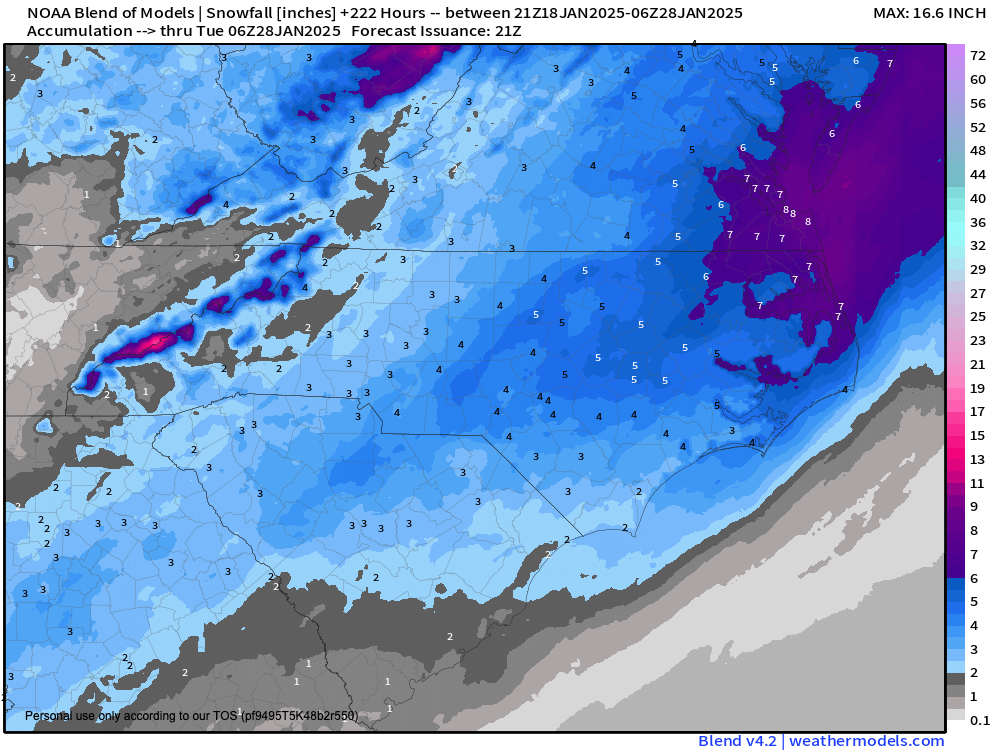
New blend .
-
Still expecting a trace to half inch for southeast portions of wake and into joco .
-
For NC, ensembles have been spot on for days now. Don’t look at specific amounts. Look at where they are focusing. This has been an eastern NC storm for days now. .
-
If the ensembles follow that trend, then I'm done with this one.
-
This always happens. After the huge shift yesterday, expect models to recoil back to the west today. .
-
12Z NAM has 6-9 hours of snow for eastern NC... the northwest edge gets pretty much to I-95
-
Just lends more credit to the theory that our area has to have "Goldilocks" conditions.. Too cold and we miss out to the northwest... Too warm and we miss out to the southeast. So difficult... I still think we see snow in Wake County. It may not be enough to play with, but roads will not be fun Wednesday morning
-
Chris Michaels at WRAL does a great job explaining things and keeping it real: SUNDAY UPDATE I'm not showing exact numbers this morning, but I imagine we'll put out a "first-call" map this afternoon for what's to come Tuesday evening-early Wednesday. Let me explain why. - I don't believe in jerking you guys around with a change in the forecast every 6-12 hours. We've been consistent in saying the coast gets the most out of this. - For instance, a shift of 25-50 miles changes everything you see Tuesday evening/early Wednesday. Saturday morning, Raleigh's odds of 1" of snow were 55%. Sunday morning, they're 29% because of a subtle shift east in the modeling. - The best chance of 1" of snow or more is near/east of I-95. - Weather balloon data will begin showing up in the models we get between 11a and 1p today. That should give us some clarity. - By Sunday afternoon, you'll have 48+ hours of lead time. That's more than enough. Being first is cool, but putting together as accurate and clear a forecast as possible takes priority.
-
RAH says in their morning discussion that snow is still likely from generally US-1 to the east. .
-
Depends where you live. We barely got a half inch of sleet in southern wake with maybe five snowflakes. .
-
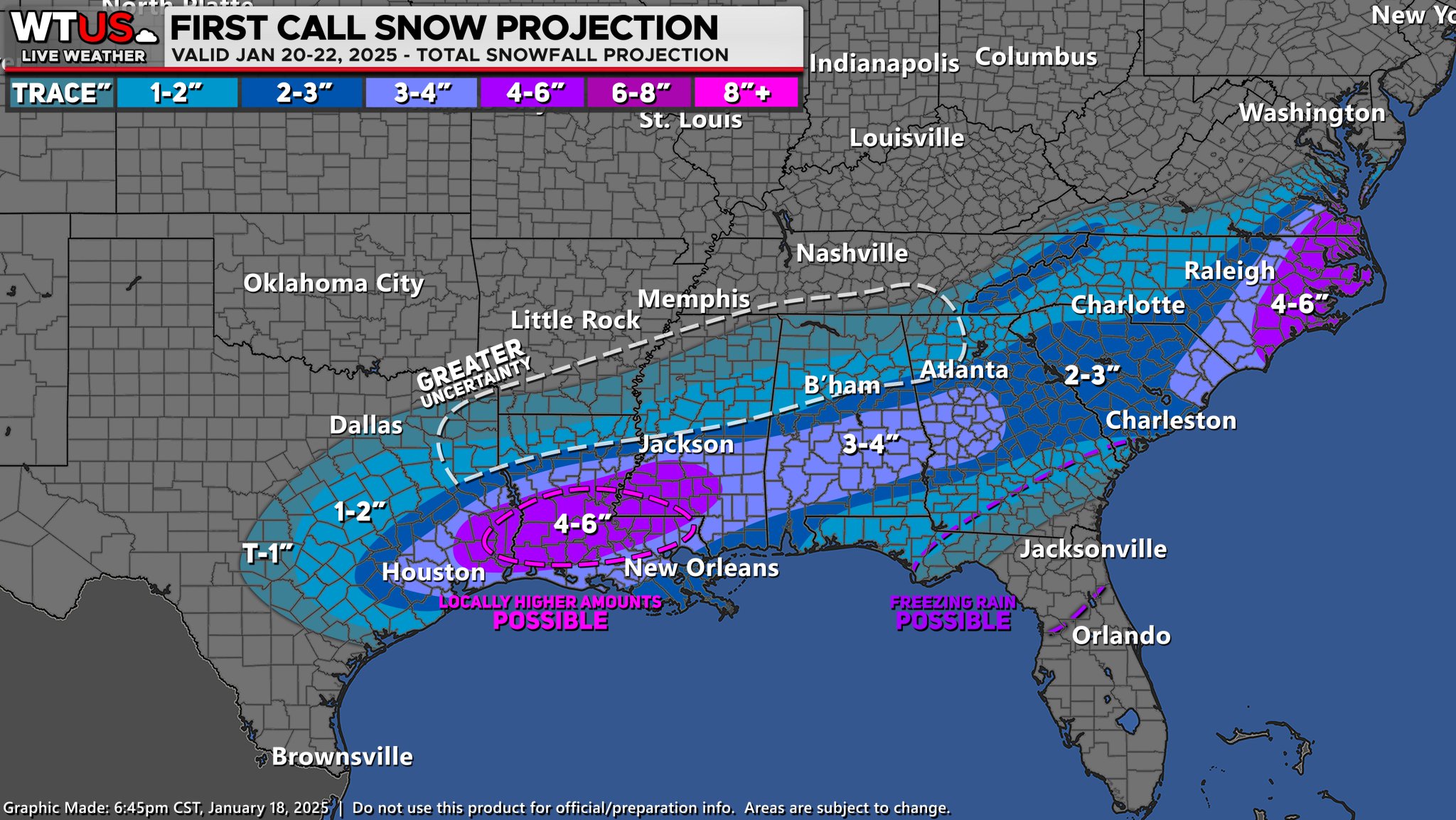
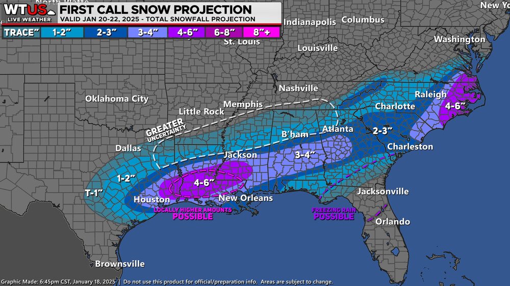
Weather track first call .
-
I’m still very happy with where things are. Blend of models and EPS looks good for my area. .
-
Nothing new from GFS so no worries. GEFS has always looked better which says the deterministic is held up on some bad data. Outlier. .
-
How in the world are some of you throwing in the towel? No, this isn’t going to be a ten inch snow for central NC, but a lot of folks are still going to see a nice snow (even if only an inch). I still consider myself on a snow drought bc all we got was sleet during the storm on the tenthth. The signals are great for central NC to the coast to get some snow. No mixing issues and high ratios. Plus instant sticking due to super cold antecedent conditions. .
-
Of course
-
-
The euro is showing normal ratios. They will be higher so increase those amounts by one inch .
-
It is still very much game on for garner, fuquay, knightdale, Clayton, benson, Wilson, Smithfield, etc etc etc. .
-
The GEFS is better and gets light coverage up to I-95....i notice it is also slower than other models
-
Once again, the GFS stays flat and has the same track, but doesn't crank up enough to produce enough precipitation.
-
GFS has snow all along the coast, albeit light
-
EPS probabilities: Areas east of I-95 have at least a 75% chance of 1" of snow, increasing as you go further east. Wake County probabilities vary 45-70% from Morrisville to Fuquay. 3" probabilities is 20-40% from west to east across Wake 50% or greater east of I-95 The ENTIRE state of NC has at least 80% chance of dusting. Never seen that before.