PackGrad05
-
Posts
1,974 -
Joined
-
Last visited
Content Type
Profiles
Blogs
Forums
American Weather
Media Demo
Store
Gallery
Everything posted by PackGrad05
-
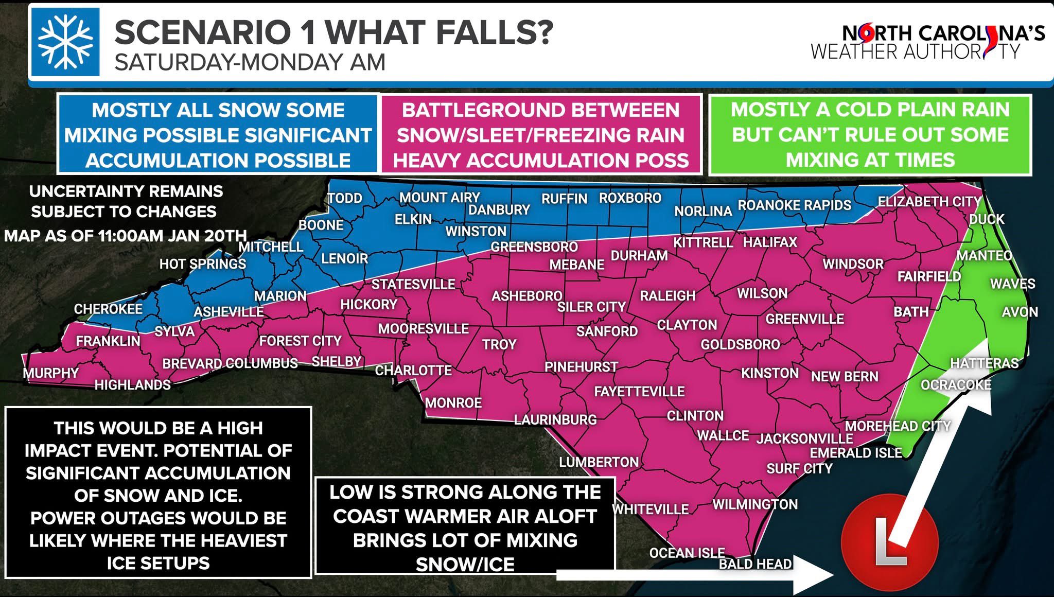
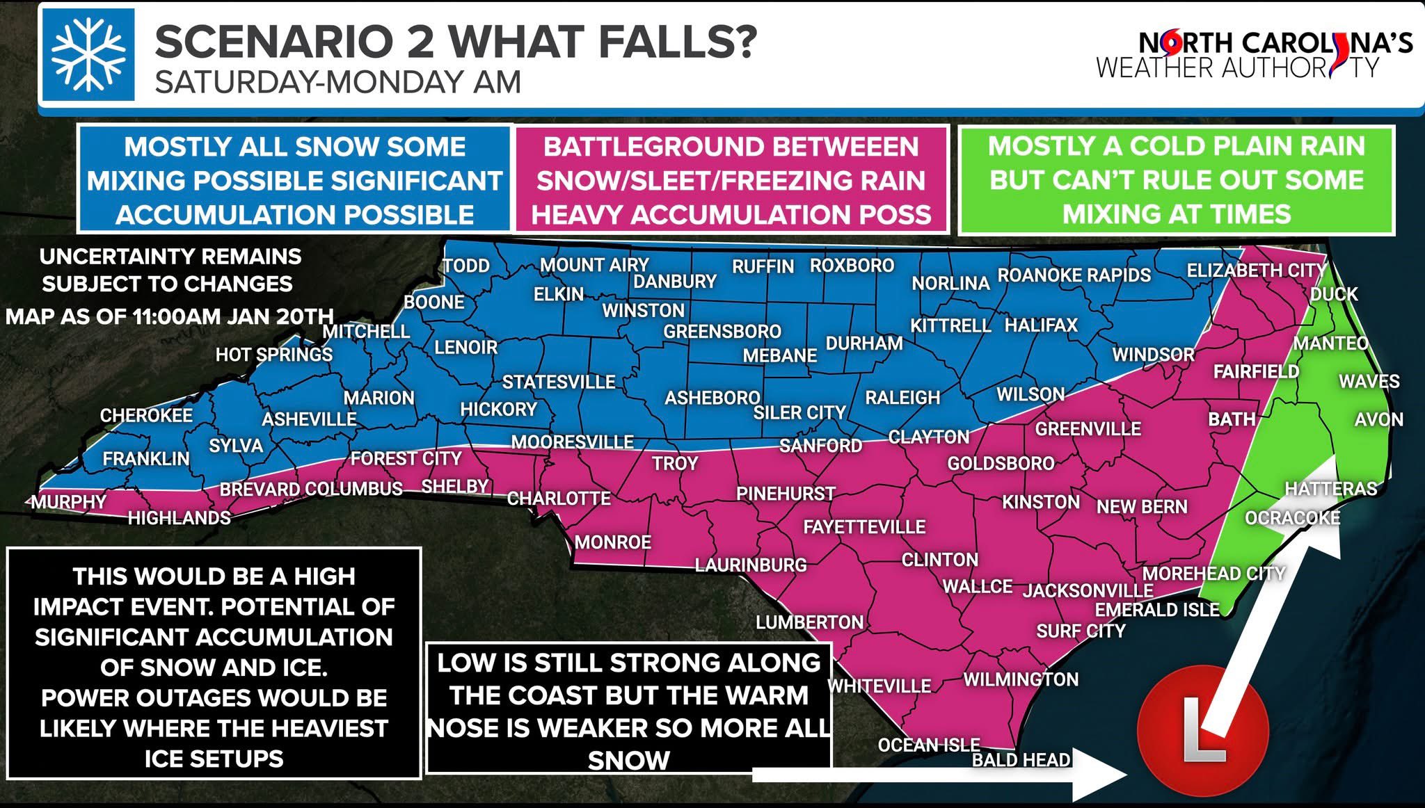
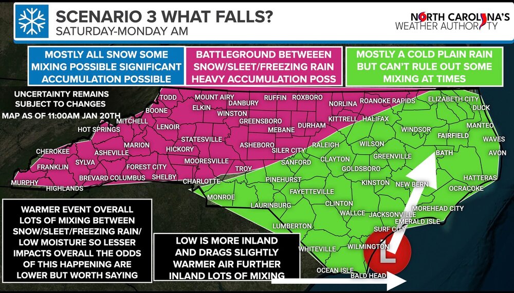
Ethan put out his three possibilities

-
In anyone's backyard. The snowfall map does not take into consideration mid-level thermals at all locations. As depicted, some of that "snow" will be ice/freezing rain.
-
The total snowfall map that BRICK posted. That will NOT be all snow.
-
Maybe so, but that still points towards an ICY MIX and not all snow. Once again, the storm is too strong and not placed well for central NC to have all snow.
-
I didn't say I was. They are certainly possible and I'm always hoping for a lot of snow. But climatology leans toward UK.
-
Don't write off the UK just because you don't like it. That is a possible scenario for sure. Climatology favors a mix for most of NC.
-
Over 40 years of experience and climatology... Plus the fact that we are still days away.
-
I'm telling you, this may be the most likely outcome. This is far from a slam dunk snowstorm.
-
Based on location of high pressure and the current upstream dynamics, I'm predicting a more northerly track that puts most of NC south of 85 in the warmer sector. Freezing rain/sleet dominates.
-
90% of the time, Wake is a battle zone. Geographically it's just the way it works, due to position in the state, distance from Apps, and the north/south length of the county. Very very very rare for the entire county to get the same thing. Down here in southern wake i'd be happy with 1-2 inches of snow.
-
Freezing rain is self limiting, unless you have a constantly resupply of cold air at the surface. As the rain freezes, it releases heat which warms the air. So unless you have new cold air moving in, it is limited. Also, the wake county battle zone is showing up remarkably well. It’s certainly not going to be all snow. Snow/sleet mix for most in central NC. Hopefully limited freezing rain but needs to be watched. .
-
Not liking the trends for wake. Especially southern wake. More mixing. Less snow. Too far out to look at totals. I’m looking at trends. Climatology also .
-
I see the classic wake county gradient on the euro! .
-
90% of the time, there will be a central NC cutoff... You can bank on it. Most of the time that is snow/rain. This time it may be snow/ice. But the cutoff is always there. Look at that EURO run. Over 50-75 miles you go from 17" to no snow. Setting up around southern Wake as usual.
-
The EURO AI has the classic southern wake county screw zone
-
yeah the EPS is still solidly showing 1-2" of snow for Raleigh.. very very wrong currently.
-
Not surprising at all. It’s been such a cold start to the month, knew we’d snap back the other way. With that said, GFS always shows extreme swings in long range. Probably more like upper s. .
-

The Monday wintry event potential (12/8/25)
PackGrad05 replied to GaWx's topic in Southeastern States
nothing but rain still in southern wake. -
The Monday wintry event potential (12/8/25)
PackGrad05 replied to GaWx's topic in Southeastern States
41 in Willow Springs on my Tempest. Latest HRRR looks better. -
The Monday wintry event potential (12/8/25)
PackGrad05 replied to GaWx's topic in Southeastern States
Both the NAM and HRRR want to redevelop moisture across central NC around 7-10PM -
The Monday wintry event potential (12/8/25)
PackGrad05 replied to GaWx's topic in Southeastern States
True. But looks better than last Friday's system for sure. -
Seeing the classic pattern in the high-res models of mountain snow, followed by a piedmont lull, and a NE NC jackpot.
-
The 12Z HRRR is not much different than the 6Z when you look at total moisture and placement.... The difference with the snowfall map is due to difference in temperatures which keep most of it cold rain for the areas that are "blanked." I'm not surprised by this because the cold air is chasing the moisture and surface temps will likely be above freezing until sunset. So there could definitely be a mix or snow falling, but not sticking.
-
12Z EURO and EPS both increased coverage/amounts for NC for Monday's small system. GFS still leads the way with highest amounts.
-
The rain/snow line on the 00Z HRRR is pretty much identical to 18Z. The main difference is that it reduced totals by half in NC. At least for the triangle, this has all the makings of some initial sleet/snow falling for a short period of time (if that) and then quickly going to all cold rain.