

PackGrad05
-
Posts
1,974 -
Joined
-
Last visited
Content Type
Profiles
Blogs
Forums
American Weather
Media Demo
Store
Gallery
Everything posted by PackGrad05
-
I saw that and I also saw that the new model data would not be in the NBM until 19Z
-
Remember that on the NW edge of that shield, ratios will be BETTER than 10:1
-
I'm 2 miles from JOCO
-
12Z Euro looks great. Can I ask how you get it so fast? I use weathermodels.com and the 12Z euro isn't loaded yet.
-
That's very strange. which site did you use to view the model?
-
It improved a lot from previous run. Much more moisture and more NW slightly
-
Brad P just released a great video for those wanting more info about why it may or may not move northwest. Has to do with the strength of the system. If it doesn't get stronger, it will stay more south. and he even mentioned CONSISTENCY with overall track of the system being a coastal runner
-
the reason the NBM increased is because it takes into account ALL the ensembles.
-
-
GFS looks like it tries to phase more with a wave near CA and stays flatter... Euro misses the phase and does more a Miller A
-
GEFS has been remarkably consistent with 1" probabilities for central NC. Approximately 10-20% chance over the last three runs. You knew the models would suppress today after all the talk on TV about northwest trends. That's why Brad P was so hesitant to bite on it.
-
That GDPS had the classic signal of an NE NC snowstorm, elizabeth city version
-
Yes they are. At this range, they all show an eastern NC system. Too early to even begin looking at specific amounts. I'm talking about the track and who is impacted.
-
This is why I was very surprised that tv Mets were mentioning NW trend so much. It isn’t guaranteed in these events. This isn’t your average type of event With that said models are good consensus now .
-
GFS is coming in line with euro. They are meeting in the middle .
-
When wral discussed “models” they are talking euro and American. Mainly euro. They put a lot of weight on euro. .
-
I can go ahead and tell you what will happen. All the models are being consistent with their means. Yes there are a few outliers but we have good consensus. This will be an eastern NC storm with the transition line somewhere around wake county. Take your typical NC storm and flip it horizontally and there you go. Coast will also see mixing due to warm nose close to the low. .
-
The euro AI is not handling the system well upstream. It did the same with the last system. Upstream perturbations resulted in downstream errors. This is common with AI models. .
-
This is a time when I love being in the southeast corner of wake. EPS looked good .
-
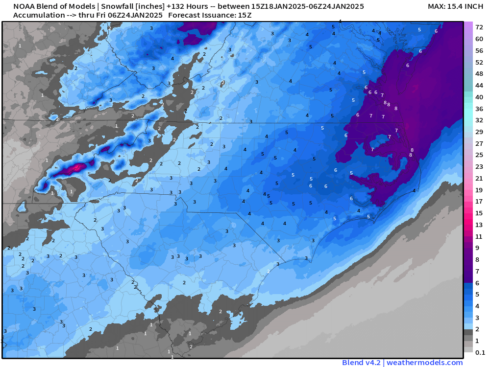
The EPS showed an inch of snow for central NC on the 1/21-1/22 system and then another inch from a system 1/24-1/26
-
The euro ensembles are on board .
-
Gfs ensembles and euro ensembles are very similar .
-
Brad P said on X that there has not been a NW trend. He says the low track and vorticity has not moved NW, only the snow maps.
-
Euro and its ensembles continue to improve... and with the super cold temps, that stuff will stick instantly and stick around a while.
-
All models are wrong. Some are useful. Still too much spread, especially with ECMWF and EPS being the most suppressed at this time.


