

ShawnEastTN
-
Posts
1,951 -
Joined
-
Last visited
Content Type
Profiles
Blogs
Forums
American Weather
Media Demo
Store
Gallery
Everything posted by ShawnEastTN
-
Oak Moon Upslope/ Upper Low Storm Obs
ShawnEastTN replied to Holston_River_Rambler's topic in Tennessee Valley
Really impressed with the amount of upstream moisture still to work through. Still good moisture all the way up in to Illinois and Indiana rotating this direction.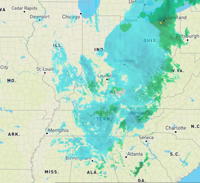
- 300 replies
-
- 4
-

-
- upslope snow
- upper level disturbance
- (and 3 more)
-
Oak Moon Upslope/ Upper Low Storm Obs
ShawnEastTN replied to Holston_River_Rambler's topic in Tennessee Valley
Agree, makes sense considering the good valley flakage here. Normally in NW flow I get very fine flakes that are pretty dried out if I get anything at all. Today I've gotten off and on fluffy flakes that just didn't feel NW flow like. Sent from my SM-G965U using Tapatalk- 300 replies
-
- 2
-
-
- upslope snow
- upper level disturbance
- (and 3 more)
-
Oak Moon Upslope/ Upper Low Storm Obs
ShawnEastTN replied to Holston_River_Rambler's topic in Tennessee Valley
First sort of moderate snow, honestly never expected this in the valley. Sent from my SM-G965U using Tapatalk- 300 replies
-
- 3
-
-
- upslope snow
- upper level disturbance
- (and 3 more)
-
Oak Moon Upslope/ Upper Low Storm Obs
ShawnEastTN replied to Holston_River_Rambler's topic in Tennessee Valley
That's what I'm hoping for too. That's sort of how it started for me then over to flakes that vary in intensity off an on for the last 30 minutes or so. I'm hoping the RGEM is correct in depicting another lobe of energy making its way through after dark, think that will be our best shot in the low elevations at a little dusting since it'll be colder and squeeze out every drop of moisture. Sent from my SM-G965U using Tapatalk- 300 replies
-
- 1
-
-
- upslope snow
- upper level disturbance
- (and 3 more)
-
Oak Moon Upslope/ Upper Low Storm Obs
ShawnEastTN replied to Holston_River_Rambler's topic in Tennessee Valley
Finally getting just flakes now at a nice clip. Sent from my SM-G965U using Tapatalk- 300 replies
-
- 3
-
-
- upslope snow
- upper level disturbance
- (and 3 more)
-
Oak Moon Upslope/ Upper Low Storm Obs
ShawnEastTN replied to Holston_River_Rambler's topic in Tennessee Valley
Can confirm this radar return is mix rain snow and reaching the ground. Still sitting at 38/39 degrees. Sent from my SM-G965U using Tapatalk -
Oak Moon Upslope/ Upper Low Storm Obs
ShawnEastTN replied to Holston_River_Rambler's topic in Tennessee Valley
Had rain graupel/melted snow flake slop a few minutes ago on the Roane/Meigs county line area. Sent from my SM-G965U using Tapatalk- 300 replies
-
- 1
-
-
- upslope snow
- upper level disturbance
- (and 3 more)
-
Oak Moon Upslope/ Upper Low Storm Obs
ShawnEastTN replied to Holston_River_Rambler's topic in Tennessee Valley
0z RGEM seems to have slightly ticked up snow totals across the whole of the area. Running through frames to my untrained eye it seems to pick up on a piece of energy rotating down out of Southern Indiana around 14z monday into Kentucky then Tennessee through the evening and night, even appearing to over come downsloping in the great valley. Sent from my SM-G965U using Tapatalk- 300 replies
-
- 2
-
-
- upslope snow
- upper level disturbance
- (and 3 more)
-
December 2020 Medium/Long Term Pattern Discussion.
ShawnEastTN replied to John1122's topic in Tennessee Valley
Absolutely! At least it used to always be that way right about this timeframe we lose it and hope is dashed then triumphantly comes back about 24 hours later. Hopefully the case here but it is 2020 so probably going to evolve to massive severe event and no freezing precip except damaging hail. Sent from my SM-G965U using Tapatalk -
Wild Speculation for Winter 20 -21
ShawnEastTN replied to Holston_River_Rambler's topic in Tennessee Valley
I smell a AN November coming on... Maybe that'll help with timing of colder blasts at climatological best opportunities of winter. Then again it seems over the last several years the correlations that seemed reliable in years past aren't as reliable today. Sent from my SM-G965U using Tapatalk -
TN valley heavy rain/flooding week of whenever
ShawnEastTN replied to janetjanet998's topic in Tennessee Valley
Just hit the 1" mark imby today. Sent from my SM-G965U using Tapatalk -
TN valley heavy rain/flooding week of whenever
ShawnEastTN replied to janetjanet998's topic in Tennessee Valley
Started raining IMBY according to my weather station at 4am (northern Meigs county) currently since it started I'm sitting at .72 inches for the day with rainfall rates bouncing between .12" up to as high as .29" an hour so far. Sent from my SM-G965U using Tapatalk -
TN valley heavy rain/flooding week of whenever
ShawnEastTN replied to janetjanet998's topic in Tennessee Valley
Crazy stuff, verbatim that puts just at or just under 13" of rain in my back yard over 10 days. Being winter there just isn't anything to drink up that water from the soil. Could make last February's flooding look trivial. Sent from my SM-G965U using Tapatalk -
TN valley heavy rain/flooding week of whenever
ShawnEastTN replied to janetjanet998's topic in Tennessee Valley
I've now passed the 3" mark since midnight, sitting at 3.16" Sent from my SM-G965U using Tapatalk -
TN valley heavy rain/flooding week of whenever
ShawnEastTN replied to janetjanet998's topic in Tennessee Valley
Currently sitting at 2.48" since midnight, and .30" yesterday. Imby Northern Meigs County. Think Morristown forecast amounts are far too low for this event! Sent from my SM-G965U using Tapatalk -
TN valley heavy rain/flooding week of whenever
ShawnEastTN replied to janetjanet998's topic in Tennessee Valley
Looks like you were spot on. Was way off MRX forecast, but on the back edge now of precip, and have 1.46" -
TN valley heavy rain/flooding week of whenever
ShawnEastTN replied to janetjanet998's topic in Tennessee Valley
Now at 1.10" -
TN valley heavy rain/flooding week of whenever
ShawnEastTN replied to janetjanet998's topic in Tennessee Valley
Think I am going to bust high on Precip for the day. Already at .75" and precip rates are running pretty high at times, looking at radar and current rates I anticipate around 2" minimum today, way above forecast. -
TN valley heavy rain/flooding week of whenever
ShawnEastTN replied to janetjanet998's topic in Tennessee Valley
IMBY I ended the last 2 days at .96" of rain and pretty amazed to see the impact today in the creeks. Creeks between my house and Athens have risen and turned red with such small totals. It's really strange to see, hope Sunday isn't too bad. Sent from my SM-G965U using Tapatalk -
TN valley heavy rain/flooding week of whenever
ShawnEastTN replied to janetjanet998's topic in Tennessee Valley
Still coming down here sitting now at 5.38" for the day today. Sent from my SM-G965U using Tapatalk -
TN valley heavy rain/flooding week of whenever
ShawnEastTN replied to janetjanet998's topic in Tennessee Valley
Just started pouring here again thunderstorm type rates. Sent from my SM-G965U using Tapatalk -
TN valley heavy rain/flooding week of whenever
ShawnEastTN replied to janetjanet998's topic in Tennessee Valley
My February to date. 12.77" more than 1/3 of that month to date was today so far. [emoji2962] Sent from my SM-G965U using Tapatalk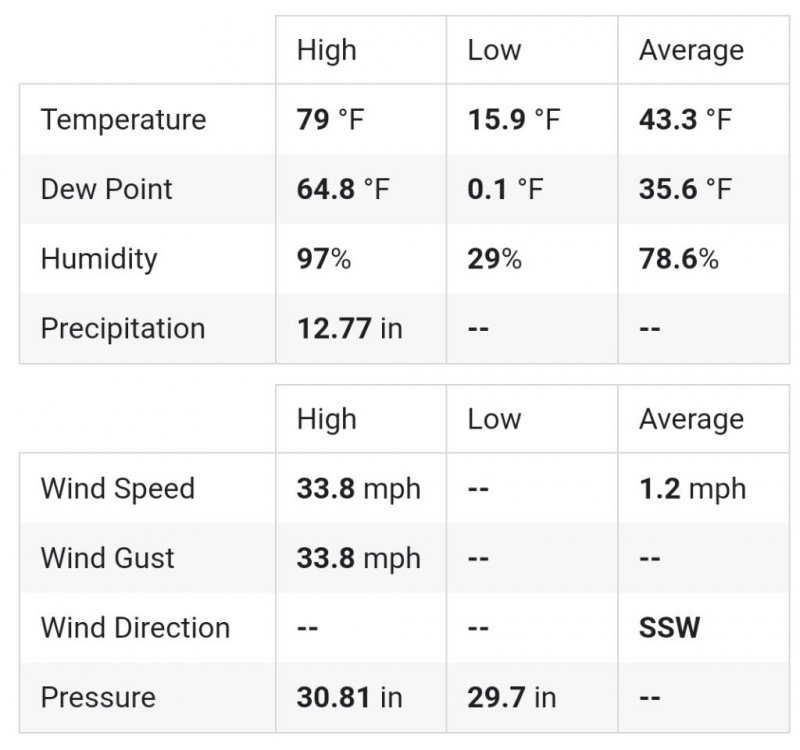
-
TN valley heavy rain/flooding week of whenever
ShawnEastTN replied to janetjanet998's topic in Tennessee Valley
Just finally out of that train IMBY. Since midnight 4.67" for the day so far. Sent from my SM-G965U using Tapatalk -
TN valley heavy rain/flooding week of whenever
ShawnEastTN replied to janetjanet998's topic in Tennessee Valley
I have noticed that as well. They tend to use areal way more. Sent from my SM-G965U using Tapatalk -
TN valley heavy rain/flooding week of whenever
ShawnEastTN replied to janetjanet998's topic in Tennessee Valley
Subway restaurant Signal Mountain destroyed by mudslide. Sent from my SM-G965U using Tapatalk


