

ShawnEastTN
-
Posts
1,951 -
Joined
-
Last visited
Content Type
Profiles
Blogs
Forums
American Weather
Media Demo
Store
Gallery
Everything posted by ShawnEastTN
-
TN valley heavy rain/flooding week of whenever
ShawnEastTN replied to janetjanet998's topic in Tennessee Valley
I can't get over how heavy the rain is at times. Just had summer thunderstorm precip rates for about 10 minutes. It does that let's up a little then right back to it. I'm now past 3" since midnight. Sent from my SM-G965U using Tapatalk -
TN valley heavy rain/flooding week of whenever
ShawnEastTN replied to janetjanet998's topic in Tennessee Valley
Went to bed it wasnt even raining. Thought well it won't be that bad. Wake up yard is flooded, rain gauge showing 2.89" since midnight. Sent from my SM-G965U using Tapatalk -
TN valley heavy rain/flooding week of whenever
ShawnEastTN replied to janetjanet998's topic in Tennessee Valley
I was thinking the same thing. Strong language, they are definitely taking it seriously for sure. Though IMBY, I cannot remember a wetter winter either. Just since last Friday IMBY I've recorded 5.3" of rain, of course that's on top of all the wet weather before. I think it is an exceptional situation considering the time of the year with no plant life to assist in taking in that water from the soil. Sent from my SM-G965U using Tapatalk -
TN valley heavy rain/flooding week of whenever
ShawnEastTN replied to janetjanet998's topic in Tennessee Valley
Yeah now that you mention it they drew into MEG also. Interesting usually they stop short of crossing into neighboring CWAs, or just barely draw into a neighbor but the definitely didn't use that restraint in that graphic. Sent from my SM-G965U using Tapatalk -
TN valley heavy rain/flooding week of whenever
ShawnEastTN replied to janetjanet998's topic in Tennessee Valley
They drew that graphic all the way into MRX area I'm in their concern area. Sent from my SM-G965U using Tapatalk -
TN valley heavy rain/flooding week of whenever
ShawnEastTN replied to janetjanet998's topic in Tennessee Valley
I ended just under 2" from yesterday IMBY, it won't take much to have road closures in my area from flooding, some areas are teetering on it already. Sent from my SM-G965U using Tapatalk -
TN valley heavy rain/flooding week of whenever
ShawnEastTN replied to janetjanet998's topic in Tennessee Valley
A lot of thunder and lightning rates have really picked up. Just checked and now at 1.25". Sent from my SM-G965U using Tapatalk -
TN valley heavy rain/flooding week of whenever
ShawnEastTN replied to janetjanet998's topic in Tennessee Valley
Closing in on .75" and a long ways to go looking at the radar for the night. Sent from my SM-G965U using Tapatalk -
TN valley heavy rain/flooding week of whenever
ShawnEastTN replied to janetjanet998's topic in Tennessee Valley
I bet as the week goes on we are going to see more rock slides and highway slides. So much water has undercut rock above roads and under roadways that both occurrences I think will tick up. Sent from my SM-G965U using Tapatalk -
TN valley heavy rain/flooding week of whenever
ShawnEastTN replied to janetjanet998's topic in Tennessee Valley
Thunder and lightning IMBY. Sent from my SM-G965U using Tapatalk -
TN valley heavy rain/flooding week of whenever
ShawnEastTN replied to janetjanet998's topic in Tennessee Valley
.72 Friday night IMBY on the Tennessee River on Watts Bar Lake. So far today .87 looking as though will end probably around 1.5 by morning looking at rates. Creeks are running high, going to be an interesting week. Sent from my SM-G965U using Tapatalk -
Historic Tennessee Valley Cold, Snow, and Ice Events
ShawnEastTN replied to Carvers Gap's topic in Tennessee Valley
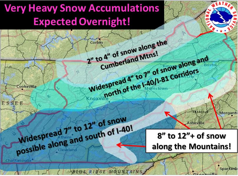
One of my favorite busts in a winter forecast in recent memory was February of 2015, its actually interesting to go back and look at the forecast thread and then the obs thread here on the forum for the event because it was such a serious bust for many. Initially the morning of the storm WWAs were issued for most of the great valley for 2-4". Then the event started in the late afternoon for southern areas around chatt, and was way over performing, MRX bumped to WSW for 3-6", then kept updating their snowfall graphic upward. Couple of those clips from the old thread below, by the time all was said and done many got between 7-12".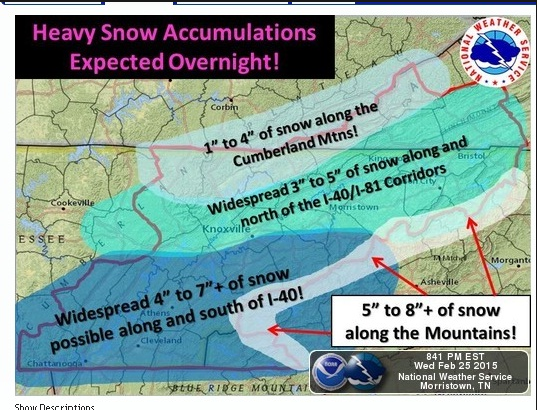
-
Historic Tennessee Valley Cold, Snow, and Ice Events
ShawnEastTN replied to Carvers Gap's topic in Tennessee Valley
93 has seared my brain forever. Almost everything you mention even for the valley is spot on, 2 days before watching WRCB in Chattanooga Paul Barys coming right out and saying very frankly we are in for a potential blizzard and used the word blizzard. I remember people saying he was crazy all the way up till the storm, then couldn't believe he was right. I do remember it raining at my house until about midnight that night, then giant wet flakes and the wind was literally howling outside. I remember waking up at about 4AM because the wind literally was loud, peaked out the door only for the wind to blow a crazy amount of snow in so I slammed it shut, then went to the window and could barely see the street light just outside the house by about 100 feet, it was snowing so hard it was blurred that much. Then to my complete shock I witnessed then and still the only time in the eastern US, thundersnow. Everything ourside went purple, I say everything but really it was just snowing so hard you could only see just this bright purple flash then the thunder which was muffled but definitely thunder after it was pretty incredible. Then of course having no power for a week afterward, and the morning after all you could smell was pine from all the fallen trees. So much damage, it was incredible. My yard averaged 20" of snow with drifts up to 5', I was 13 and 5' snow drifts were up to my armpits. Will never forget that storm!

