high risk
-
Posts
3,150 -
Joined
-
Last visited
Content Type
Profiles
Blogs
Forums
American Weather
Media Demo
Store
Gallery
Everything posted by high risk
-

December 16-17, 2020 Winter Storm Obs/Nowcasting
high risk replied to WxUSAF's topic in Mid Atlantic
I am on board with those chances, but if you look at the simulated radars, the stuff near RNK actually comes through as another round of RA/IP/ZR later this evening. The potential snow band just after midnight seems to form out over eastern WV with the upper trough axis and then rotates through our area. -
December 16-17, 2020 Winter Storm Obs/Nowcasting
high risk replied to WxUSAF's topic in Mid Atlantic
some modest glaze on the trees here in southern Howard County -
December 16-17, 2020 Winter Storm Obs/Nowcasting
high risk replied to WxUSAF's topic in Mid Atlantic
for the Columbia crowd, it has now gone to sleet here in North Laurel after close to 2" of snow. So enjoy the SN+ while you can. -
December 16-17, 2020 Winter Storm Obs/Nowcasting
high risk replied to WxUSAF's topic in Mid Atlantic
nothing. The hourly maps show a lot of sleet in the DC-NYC corridor, and the snow map simply applies a 10:1 ratio to the liquid amount being generated if it's snow OR sleet. -
December 16-17, 2020 Winter Storm Obs/Nowcasting
high risk replied to WxUSAF's topic in Mid Atlantic
As you noted, the core was changed, but most of the actual physics (except for the microphysics) were retained. I think that the PBL scheme plays a role in these warm layer cases. -
December 16-17, 2020 Winter Storm Obs/Nowcasting
high risk replied to WxUSAF's topic in Mid Atlantic
It's the "new" GFS, but it has the old physics, so I suspect that its inability to capture mid-level warm layers remains. -
December 16-17, 2020 Winter Storm Obs/Nowcasting
high risk replied to WxUSAF's topic in Mid Atlantic
The regular members of this subforum are perfectly capable of making uninformed posts, without the need for any outside help, but thanks. -
December 16-17, 2020 Winter Storm Obs/Nowcasting
high risk replied to WxUSAF's topic in Mid Atlantic
Agreed on all counts. The GFS typically shows way too small of a small transition zone between rain and snow. I do think that eastern Howard may get a decent sleet mess out of this. -
December 16-17, 2020 Winter Storm Obs/Nowcasting
high risk replied to WxUSAF's topic in Mid Atlantic
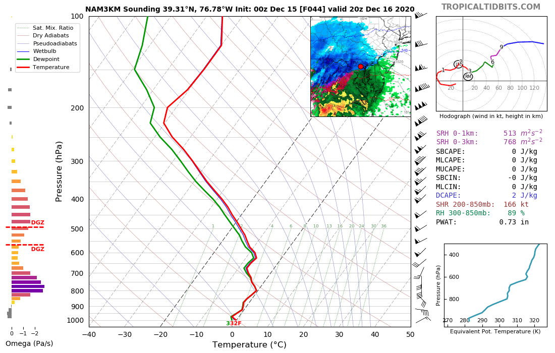
It's worth noting that in the CAMs (especially the NAM nest) that turn central and north-central MD over to sleet for a long duration, the warm layer is up around the 750 or 700 mb level. The GFS is typically very poor at capturing those warm layers if they're well above, say, the 850 level. PSU made a reference earlier to the March 2017 storm in which the GFS missed forecasting most of the sleet because it kept things much colder aloft. It isn't the same GFS now, but I would not be surprised if this weakness holds. -
December 16-17, 2020 Winter Storm Obs/Nowcasting
high risk replied to WxUSAF's topic in Mid Atlantic
the front end thump for those of us in Howard/Montgomery isn't nearly as good on the NAM nest -
December 16-17, 2020 Winter Storm Obs/Nowcasting
high risk replied to WxUSAF's topic in Mid Atlantic
100% true for this area. Well, ok, 90% true. -
exactly. no one should ever post a 10:1 map when the precip type images clearly show a ton of sleet. The NCEP models tally snow and sleet together and put out a liquid total; a 10:1 ratio applied to that has no chance to be even in the ballpark.
-
You sure about that? Both the 12 and 3 km versions seems to have snow in your area by 2 or 3pm. (I'm commenting on the precip timing, as it does look like you will go sleet.)
-
Right. Those maps don't account for actual ability to build on surfaces. They just look for rain falling with a sfc temperature at or below 32. You're spot on that without it being very cold today/tonight (i.e. mid to upper 20s), rain falling at 31 or 32 isn't likely to be a major deal. I do, however, think that parts of this area will get a big 'ole sleet bomb out of this.
-
Ok, but the HRRR has been running stupidly cold for winter precip events at longer ranges. For today's cold rain, a couple of the longer range runs had 4-6" through the DC area.
-
appears to be a respectable front-end thump for those of us north of the DC Beltway Wednesday afternoon. Temperature profiles have no margin for error, but verbatim, it would be cranking here:
-
Fair enough. It could be wrong; I'm just reacting to the folks who said that the NAM showing an inland low track proved that it should be immediately euthanized.
-
Since it seems to be the afternoon for apologies on this board, perhaps one needs to be made to the NAM......
-
FWIW, and I am not saying that it's right, the CMC evolution/track is more similar to the 00z NAM than to the 00z GFS....
-
Chill out. The NAM was frozen with its 2017 upgrade (the 3 km component has been running for way, way longer) and is slated for retirement in the 2023-2024 time frame. It's also well known that the 3 km nest is a far superior model to its 12 km parent, although it too certainly has limitations.
-
12z CMC definitely disappoints after seeing the 12z GFS
-
Absolutely. I'm a huge fan of the positive snow depth change as an alternative to the 10:1 maps, but they absolutely are driven by soil type and especially soil temperature; they tend to be a bit underdone early or late in the season when the ground temps have been warm for a few days.
-
not really. Yes, the NAM (and other regional models) will be replaced by a system that is run hourly (like the HRRR), but the new system will be FV3-based. regarding the Monday event, the HRRR is the craziest for central MD and DC, but several other hi-res models show a change to snow on the backside of the system, at least across central MD.
-
I'm not sure about the EPS, but the GEFS members are run at 25 km resolution, while the ops GFS is 13 km. So yes, that could be making a difference.
-
Definitely much more dispersive than the previous version of the GEFS.