

high risk
-
Posts
3,107 -
Joined
-
Last visited
Content Type
Profiles
Blogs
Forums
American Weather
Media Demo
Store
Gallery
Everything posted by high risk
-

2022 Mid-Atlantic Severe Wx Thread (General Discussion Etc)
high risk replied to Kmlwx's topic in Mid Atlantic
You're spot on about the instability, which was always a question for this event, as it should be for something arriving here in the early morning hours. In terms of warm-season early morning convection, I can only remember a couple of legit severe events here in 20+ years. I disagree a little bit about the consistency of the model solutions. Yes, most guidance advertised an MCC rolling through the Mid-Atlantic, but the location and details were extremely inconsistent, even hour-to-hour in the HRRR. The problem was that multiple storm complexes formed to our west and northwest yesterday and yesterday evening, and the models couldn't agree on which one would be the show here. Lots of people got super excited about the organized complex in eastern OH yesterday evening, but the models that drove a big complex through here were actually developing it from a different batch of storms in Michigan. They never handled the Ohio feature well, and I lost confidence in the setup for us as a result. I think that while the thin line that rolled through the northern areas this morning came out of that OH feature, that messed up the feature behind it, as the Michigan storms tracked more south along an instability gradient that was likely altered by the Ohio storms. Regardless, you're completely correct that MCS activity is never a sure thing. -
2022 Mid-Atlantic Severe Wx Thread (General Discussion Etc)
high risk replied to Kmlwx's topic in Mid Atlantic
I throw my hands in the air on this one. The CAMs that bring an organized MCS through here tomorrow morning generate that system out of the storms currently in western Michigan. But they don't have a good handle on the ongoing storms in northwest Ohio. Could the Ohio storms end up being the show here in the Mid-Atlantic? This is so complicated, and the outcome here is dependent upon the exact evolution upstream - this explains why the HRRR keeps bouncing around hour to hour. -
2022 Mid-Atlantic Severe Wx Thread (General Discussion Etc)
high risk replied to Kmlwx's topic in Mid Atlantic
The HREF products reflect the idea among the CAMs that the chances for what's left of the MCS to bring strong winds down to the surface is fairly low (but not zero).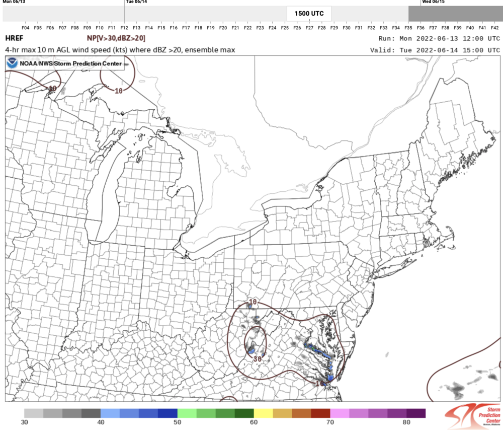
-
2022 Mid-Atlantic Severe Wx Thread (General Discussion Etc)
high risk replied to Kmlwx's topic in Mid Atlantic
I do love how the Day 2 Outlook discussed a "weakened carcass of an MCS". That said, there is still a lot of uncertainty about how and where this MCS will evolve overnight. I'm still not overly worried at this time about widespread wind potential into the metro areas, given the poor timing and lack of instability, but these systems can certainly surprise if they develop a sufficiently strong cold pool. -
2022 Mid-Atlantic Severe Wx Thread (General Discussion Etc)
high risk replied to Kmlwx's topic in Mid Atlantic
It doesn't, but 18Z HRRR and NAM Nest still suggest that a cell or two is possible closer to sunset, especially in central or northern MD. And as mentioned earlier, any sustained cell today has potential to rotate. -
2022 Mid-Atlantic Severe Wx Thread (General Discussion Etc)
high risk replied to Kmlwx's topic in Mid Atlantic
YES!!!!! You would think that, given the delay, it's going to be "interesting". -
2022 Mid-Atlantic Severe Wx Thread (General Discussion Etc)
high risk replied to Kmlwx's topic in Mid Atlantic
First, while it's not clear how much instability will be available today, and storm coverage may therefore be very limited, the shear does support some supercell structures if any storms can be sustained. Onto early Tuesday, it's hard to ignore the explicit MCS signals in several CAMs, and we all know that the overall pattern supports the idea. What's not clear to me is whether it would be a severe MCS (I'll avoid the D word for now) or just a rainy, noisy elevated MCS. Verbatim, forecast soundings suggest that the system would not be surface-based, which would reduce the threat of big surface wind, but it's certainly too early to dismiss a widespread SVR threat. -
2022 Mid-Atlantic Severe Wx Thread (General Discussion Etc)
high risk replied to Kmlwx's topic in Mid Atlantic
That's a beaut! As I mentioned a bunch of posts back, the shear closer to the shortwave and sfc low is way stronger than what we currently have, and hat shear is going to overspread our area later tonight. The HRRR thinks that instability will fall off too much to sustain the convection and take advantage of the shear, unless you're further north, but I wouldn't be surprised if there are several warnings in the LWX CWA after midnight. -
2022 Mid-Atlantic Severe Wx Thread (General Discussion Etc)
high risk replied to Kmlwx's topic in Mid Atlantic
I still don't understand how we ended up with a few modest supercells in the area. The shear on the 00Z IAD sounding is nothing of note. And the Howard County rotation suddenly emerged at the back edge of the complex that brought torrential rain to that corridor. That cell was definitely not ingesting high theta-e air. -
2022 Mid-Atlantic Severe Wx Thread (General Discussion Etc)
high risk replied to Kmlwx's topic in Mid Atlantic
The late afternoon / evening seemed to always have limited potential here. Shear is weak, and CAPE is modest; a small amount of downdraft CAPE did admittedly keep the door open for a few wind gusts (and it's probably still open), but it wasn't a strong likelihood. I'm still watching the period much later tonight along the cold front. The HRRR wants to sweep a nice line through northern and perhaps north-central MD. CAPE will be limited due to time of day, but the shear will be much improved. The HRRR is definitely more aggressive than other CAMs with this feature, so we'll see how it plays out.
-
2022 Mid-Atlantic Severe Wx Thread (General Discussion Etc)
high risk replied to Kmlwx's topic in Mid Atlantic
Timing looks a bit different on the evening guidance. Looks like the main batch of convection will occur more in the 7pm - midnight period. We'll have a bit more instability to work with, but wind profiles look very meh. So widespread severe seems unlikely, but perhaps the flash flooding potential is a bit higher. The bigger question is what happens ahead of the cold front in the early morning hours. Wind profiles will strengthen significantly, and while instability won't be impressive, there might be just enough to favorably interact with the shear. This is probably our better chance for SVR, although the CAMs don't have a lot of storms for that time - the better chance seems to be in northern MD. -
2022 Mid-Atlantic Severe Wx Thread (General Discussion Etc)
high risk replied to Kmlwx's topic in Mid Atlantic
A couple of quick thoughts about Wednesday night: We're definitely going to have an interesting convective overnight, as the strong wave lowers heights across the region and increases the shear. If this were occurring during the day, we'd likely have a good shot at some severe, but the after dark arrival of the main forcing reduces that potential. Right now, it looks like the best shear will arrive after the main round of convection, but if we can overlap storms with the improved shear, a few damaging wind gusts or an isolated tornado probably can't be ruled out. For flash flooding potential, the rapidly increasing PW values certainly make it a possibility - my initial thought is that overall dry ground and quick movement of the system will likely limit the flash flooding potential, but it's certainly on the table, especially if there is some lead convection during the late afternoon hours before the main show later at night. -
2022 Mid-Atlantic Severe Wx Thread (General Discussion Etc)
high risk replied to Kmlwx's topic in Mid Atlantic
A supercell (rotating storm) tracked right across that area on Thursday, so I think that your guess is spot on. That's clearly a wall cloud extending beneath the rain-free base, with the rain and hail (note the green hues) core on the right side of the picture -
2022 Mid-Atlantic Severe Wx Thread (General Discussion Etc)
high risk replied to Kmlwx's topic in Mid Atlantic
another round of splitting supercells along the I-66 corridor. The left mover of one split might make a run at Leesburg, while the right mover has some modest rotation southwest of Warrenton -
2022 Mid-Atlantic Severe Wx Thread (General Discussion Etc)
high risk replied to Kmlwx's topic in Mid Atlantic
rotation can compensate for poor lapse rates -
2022 Mid-Atlantic Severe Wx Thread (General Discussion Etc)
high risk replied to Kmlwx's topic in Mid Atlantic
It's easy to see several storm splits in that batch of cells along the I-50 corridor -
2022 Mid-Atlantic Severe Wx Thread (General Discussion Etc)
high risk replied to Kmlwx's topic in Mid Atlantic
It means that the deep layer shear supports a few supercells, which would of course ramp up the threats for hail and wind. The issue is that they expect widespread storms due to the forcing and lack of cap, and that will prevent the potential for longer-track supercells which are more likely when the storm mode is more discrete. Regardless, I still expect a modest number of wind reports today with the pretty good downdraft cape and decent combo of CAPE/deep layer shear (despite the meh lapse rates). -
2022 Mid-Atlantic Severe Wx Thread (General Discussion Etc)
high risk replied to Kmlwx's topic in Mid Atlantic
18Z still like south of DC for multiple rounds, but it gives one round to most of us. I'd take it. HRRR is again showing a couple of rounds for most. -
2022 Mid-Atlantic Severe Wx Thread (General Discussion Etc)
high risk replied to Kmlwx's topic in Mid Atlantic
Definitely on board with a SLGT tomorrow. Chances of multiple widespread rounds of SVR appear to have dropped a lot, but most guidance has an organized system rolling through during the late afternoon hours. With decent CAPE, good downdraft CAPE, and storm organization, there is a good chance of a bunch of wind reports. We'd need better instability and shear to get ENH. -
2022 Mid-Atlantic Severe Wx Thread (General Discussion Etc)
high risk replied to Kmlwx's topic in Mid Atlantic
Thought it a bit odd as well, guess they could mention it on the 2000z OTLK if the threat manifests itself? Yeah, they could certainly update the 20Z outlook, but @kmlwx is spot on saying that the probabilities map was certainly drawn to account for the only threat being from the ongoing activity. It doesn't go back nearly far enough west for a round 2. -
2022 Mid-Atlantic Severe Wx Thread (General Discussion Etc)
high risk replied to Kmlwx's topic in Mid Atlantic
Oddly, the new SPC Day 1 outlook only talks about the current show and has no mention of any threat later today. There is certainly still time to heat up again this afternoon. -
2022 Mid-Atlantic Severe Wx Thread (General Discussion Etc)
high risk replied to Kmlwx's topic in Mid Atlantic
Agreed. Temps are going up despite the cloud cover. -
2022 Mid-Atlantic Severe Wx Thread (General Discussion Etc)
high risk replied to Kmlwx's topic in Mid Atlantic
Agree fully that the threat for tornadoes, given the current storm mode being mostly linear, is fairly low and will be limited to brief, low-end TORs. Wind damage is the bigger threat. The wildcard, though, will be if any storm can form out ahead and remain discrete. That would be a different ballgame. Parameters are fairly good to our south - it looks like they will advect north before the line arrives, but that's still "work that has to be done". We don't currently have any src-based instability to work with. -
2022 Mid-Atlantic Severe Wx Thread (General Discussion Etc)
high risk replied to Kmlwx's topic in Mid Atlantic
I'm backing off on my enthusiasm a bit due to an increasing number of model solutions that bring convection into our area as early as midday. Probably need things to hold off a couple of hours to maximize heating in an environment that won't be excessively warm. -
2022 Mid-Atlantic Severe Wx Thread (General Discussion Etc)
high risk replied to Kmlwx's topic in Mid Atlantic
For now, I like the Friday setup. NAM Nest and HiRes FV3 both show a squall line or QLCS sweeping through the area in the late afternoon / early evening, with a fairly good environment in place ahead of the line.


