jbenedet
-
Posts
7,682 -
Joined
-
Last visited
Content Type
Profiles
Blogs
Forums
American Weather
Media Demo
Store
Gallery
Everything posted by jbenedet
-

January 2026 regional war/obs/disco thread
jbenedet replied to Baroclinic Zone's topic in New England
The huge shift of mid levels on the GEFS in like 4 runs has me shook. My take is we are having major head fakes given the MJO progression uncertainty as 7 is AN in the east with +NAO tendency, but 8 is sig BN with -NAO tendency. The guidance has been waffling on the progression for days. First was sitting in 7; then quick progression to 8; now I see a split— some showing sticking in 7, others quick to 8… It’s now that all of the latest guidance is looking a lot more like an MJO 7 synoptic pattern. The crazy part about that is if we do settle in 7, I believe this continues further north. That primary on the EC AIFS in Ontario is a shade of how much more this could trend…warmer…. I’ll make a call later this morning… Should have enough data to see which way this will break. -
January 2026 regional war/obs/disco thread
jbenedet replied to Baroclinic Zone's topic in New England
Can’t wait for the model indigestion from this impending -NAO. -
January 2026 regional war/obs/disco thread
jbenedet replied to Baroclinic Zone's topic in New England
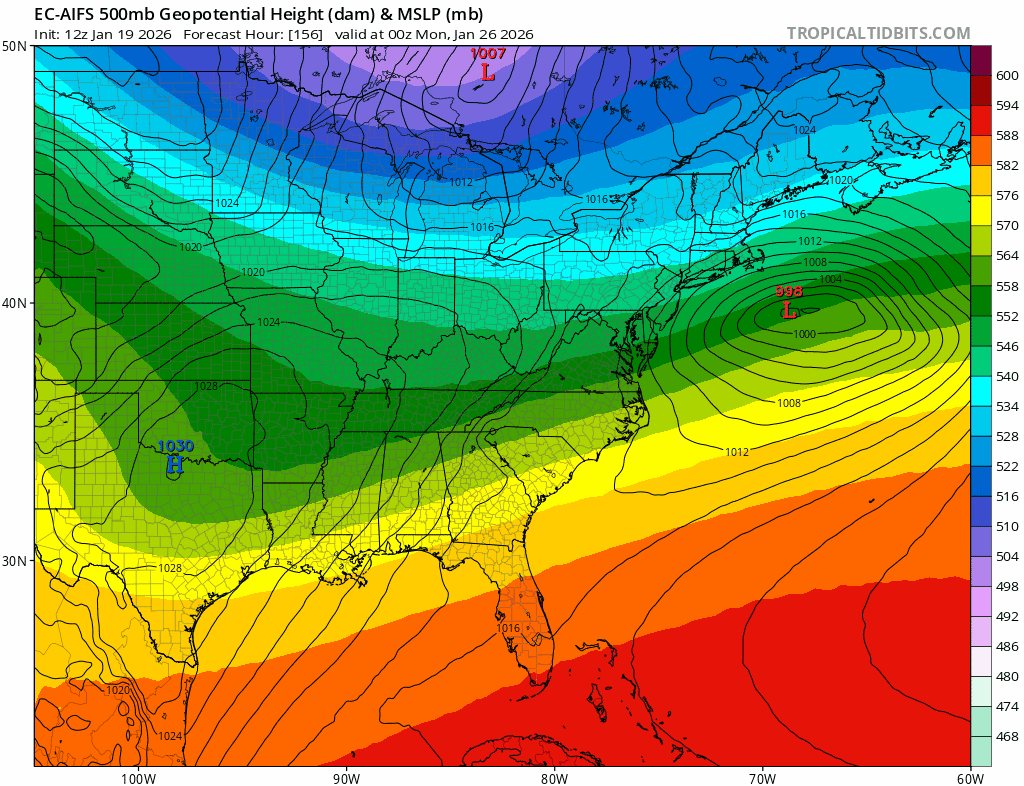
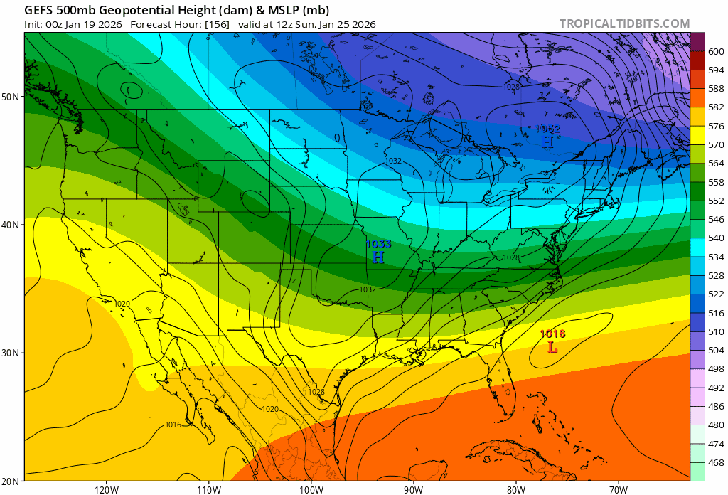
Overnight - The EC-AIFS has trended further south but also a lot more amped. the other major guidance has trended north and more amped. There’s been an improved consensus. I think it’s most telling to see the EC-AIFS amp up but that doesn’t translate to a track further north. This is important. I like the 6z EC-AIFS - its current depiction and QPF as a baseline from here. -
January 2026 regional war/obs/disco thread
jbenedet replied to Baroclinic Zone's topic in New England
Hmmm…
-
January 2026 regional war/obs/disco thread
jbenedet replied to Baroclinic Zone's topic in New England
Yea that’s where I’m at. -
January 2026 regional war/obs/disco thread
jbenedet replied to Baroclinic Zone's topic in New England
As much as I dislike DT… Seeing a 994 low off the east coast doesn’t get ya excited but if the delta is with a 1040+ mb arctic high less than 500 miles away……. It’s a big dawg. -
January 2026 regional war/obs/disco thread
jbenedet replied to Baroclinic Zone's topic in New England
No. I have said I80 south is in line for the heavy snows. I’m sticking to that. Basically NYC/LI south. definitely stay very interested in southern coast, out to south coast MA -
January 2026 regional war/obs/disco thread
jbenedet replied to Baroclinic Zone's topic in New England
You are in a spot worth watching for something more than advisory. But odds go way down just north of you imo. Watch the mid level height field compress out of New Brunswick over time; with more of a -NAO tapestry in the east. -
January 2026 regional war/obs/disco thread
jbenedet replied to Baroclinic Zone's topic in New England
More ridging but stronger surface high and positive tilt. I think the trend on overnight guidance was to load up this already-explosive setup by tightening the delta between the arctic and the tropics. -
January 2026 regional war/obs/disco thread
jbenedet replied to Baroclinic Zone's topic in New England
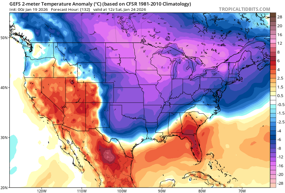
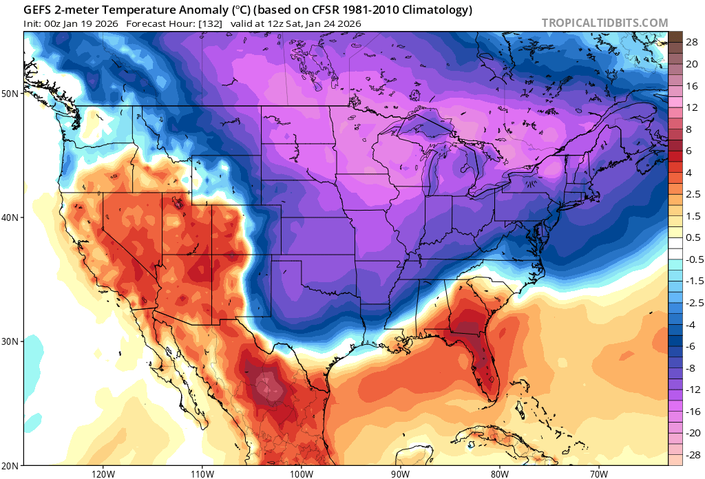
The surface high is intensifying over our heads on guidance. I’d call it Canadian but it’s over our head throughout. Filling in for Quebec.. Great news for our southern neighbors who love snow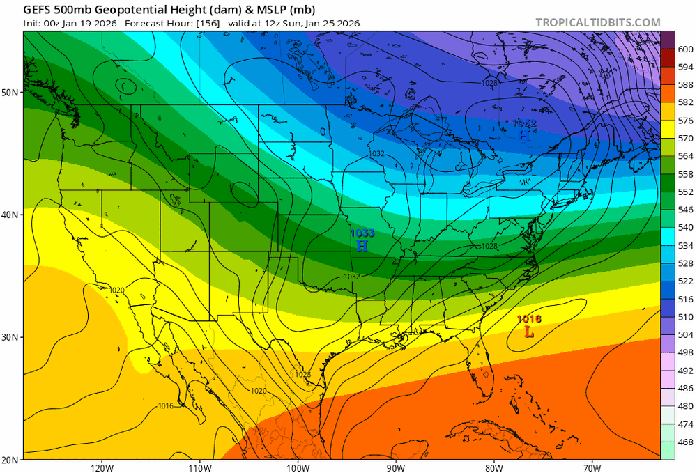
-
January 2026 regional war/obs/disco thread
jbenedet replied to Baroclinic Zone's topic in New England
Positive trade off to eliminate the daily black ice risk. Too much of this in December and January. Cities could do more, but they don’t. -
January 2026 regional war/obs/disco thread
jbenedet replied to Baroclinic Zone's topic in New England
The phasing will mean you crush mid Atlantic on the east coast with mid levels but that whole long wave trough development is severely positively tilted in the east. It’s a spin up with limited latitude gain. -
January 2026 regional war/obs/disco thread
jbenedet replied to Baroclinic Zone's topic in New England
This looking more and more like a crusher for ACY, DC, Baltimore. There is a -NAO developing around the time this makes it to the east coast, so a slower track and more phasing are likely than currently modeled. That said I don’t think that portends a big latitude gain. -
January 2026 regional war/obs/disco thread
jbenedet replied to Baroclinic Zone's topic in New England
Zzzzzz 1982-1983 was a record setting EL Nino. AN in the north; very warm winter. Meanwhile Boston running -5 in a moderate La Niña…. -
January 2026 regional war/obs/disco thread
jbenedet replied to Baroclinic Zone's topic in New England
I guess you all miss the verification scores of the EPS/GEFS vs the ops at this lead time…it’s not even close. -
January 2026 regional war/obs/disco thread
jbenedet replied to Baroclinic Zone's topic in New England
You need a new shtick. I was all over this storm. -
January 2026 regional war/obs/disco thread
jbenedet replied to Baroclinic Zone's topic in New England
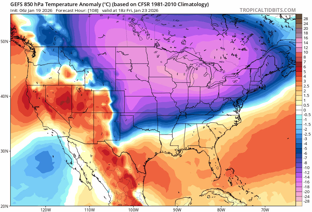
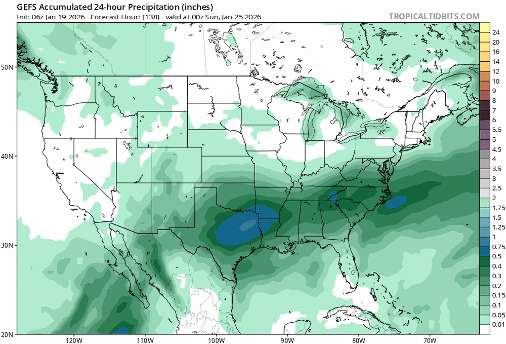
yes Richmond VA as ground zero… 5 days, but this is not a complex setup. No multiple shortwaves or potential phasing of streams type variability. I’m seeing most of the forecast is about a significant arctic airmass… the shortwave will ride the boundary… That’s it. I think we gain a day or two of guidance accuracy given the lack of complexity here. -
January 2026 regional war/obs/disco thread
jbenedet replied to Baroclinic Zone's topic in New England
To be sure, I thought the axis of heaviest precip would be closer to I80 a few days ago. Now that’s the margin to be out of this completely already, imo. Trend hasn’t been good on a “north trend” if you zoom out to few days ago. -
January 2026 regional war/obs/disco thread
jbenedet replied to Baroclinic Zone's topic in New England
Hopes and dreams. -
January 2026 regional war/obs/disco thread
jbenedet replied to Baroclinic Zone's topic in New England
In terms of lead time I’d normally agree with you. But this is as suppressive a look you can get based on airmass ( without mid level confluence). We are filling in for Canada this weekend.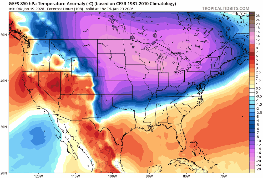
-
January 2026 regional war/obs/disco thread
jbenedet replied to Baroclinic Zone's topic in New England
You don’t take the op runs over the EPS /GEFS at this stage. Inside day 4 you might start weighing them similarly. -
January 2026 regional war/obs/disco thread
jbenedet replied to Baroclinic Zone's topic in New England
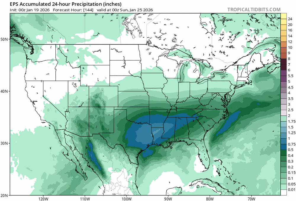
North of I80 in PA is out of the game on the weekend threat. -
January 2026 regional war/obs/disco thread
jbenedet replied to Baroclinic Zone's topic in New England
-
January 2026 regional war/obs/disco thread
jbenedet replied to Baroclinic Zone's topic in New England
Yea timed with peak winter climo as well. -
January 2026 regional war/obs/disco thread
jbenedet replied to Baroclinic Zone's topic in New England
Good luck on that…