jbenedet
-
Posts
7,800 -
Joined
-
Last visited
Content Type
Profiles
Blogs
Forums
American Weather
Media Demo
Store
Gallery
Everything posted by jbenedet
-
Fort Myers Ground zero. No break from the eye, constant southwest flow—brutal, wind, wave, surge combo for 6 hours.
-
Yea that would be a big deal in savannah area. They don’t get hit often by canes and one that hits at a right angle is especially unusual. Probably lots of vulnerable areas even in a cat 1.
-
It will be landfall, technically, but with 5 + ft of water underneath all quadrants, Ian says otherwise.
-
First Semblances of the classic buzz saw sat appearance that is common with cat 5’s. Eye gaining symmetry on satellite as well.
-
Ian looks at his best. Beautiful CDO. Symmetrical, uniform cold cloud tops. Firing on all cylinders. First full Appearance of a cat 5 from a satellite standpoint imo. https://www.tropicaltidbits.com/sat/satlooper.php?region=09L&product=ir
-
Sounds like hyperbole, but an apt metaphor is a tsunami. Nature abhors a vacuum.
-
The flooding will be from all directions in that area. If the surge misses you directly you still have the canals, rivers, lakes and streams to worry about, and myriad potential outcomes for spill over. Lake tarpon looks like a prime candidate.
-
@USCG RS Yup. Just makes it more interesting to watch. If Ian was going to get shredded in the Atlantic who cares if it makes it? Being a strong major, also gives more opportunity for short term surprises in track; as we are all seeing. Just watching with keen interest. This is a great one.
-
Interesting that guidance which has Ian move into the Atlantic re-intensify. Conditions: Favorable -> unfavorable --> favorable.
-
12z GFS initialized with a 975mb pressure. Still gets down to 960, 18z wed. If we applied a 15 mb drop to Ian at 963 mb, we're looking at 948 mb by 18z tomorrow. That's conservative based on current sat presentation.
-
Still see a heading slightly east of due north.
-
Touche. Also, did any model that had Ian at this lat/lon, miss Fla peninsula? Not really a surprise at this point but a LF on the peninsula should be a lock as far as TC weather prediction goes.
-
No doubt the upper Air environment, synoptically becomes unfavorable upon closest approach to Fla, but Cat 3+ hurricanes, in the tropics can create their own inertial envelopes of stability (if you will) which can greatly impede the rate of weakening so long as the TC is not encountering land and the SST's are strongly supportive to TC development. This looks like a classic test-case. Majors are majors for a reason - they can greatly shape the mesoscale atmosphere around them. Let's watch.
-
Call it what you want. If Florida was 300 miles NE you’d be seeing heavy rain there. But no obs over the Atlantic. This feature extends back west, closer to the TC. There’s clearly a non-tropical enhanced forcing taking place in the region I mentioned. With the delta T/delta n delta Td/delta n down there you’re going to see Synoptic driven forcing more like what we see in the mid latitudes and north. Bank on it.
-
Looks like a PRE setting up from Fort Myers east through Orlando on down to southern tip of Florida, including Miami. Model guidance could really be under-estimating the rainfall threat if not keying on this feature. Looks like moderate to heavy rain continues in this area through landfall, some 48 hrs out…
-
And Tampa metro has gained ~70,000 people since 2020….
-
The tracks into western Florida are of very significant impact while the tracks into the panhandle look like weak TS impacts (at least by Fla standards). Quite the dichotomy.
-
Yea. Along these lines, you can clearly see based on steering flow that there is a few scenarios where this could really stall near TB, but that isn't being well advertised by the guidance. The right hook into TB would lead to a faster rate of weakening due to landfall, and being less vertically stacked while the low to mid level flow becomes increasingly ambiguous. This could allow Ian to meander near the west coast of Fla as a TS, which would result in a severe rainfall threat.
-
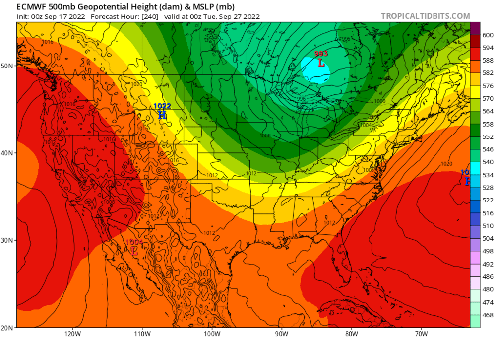
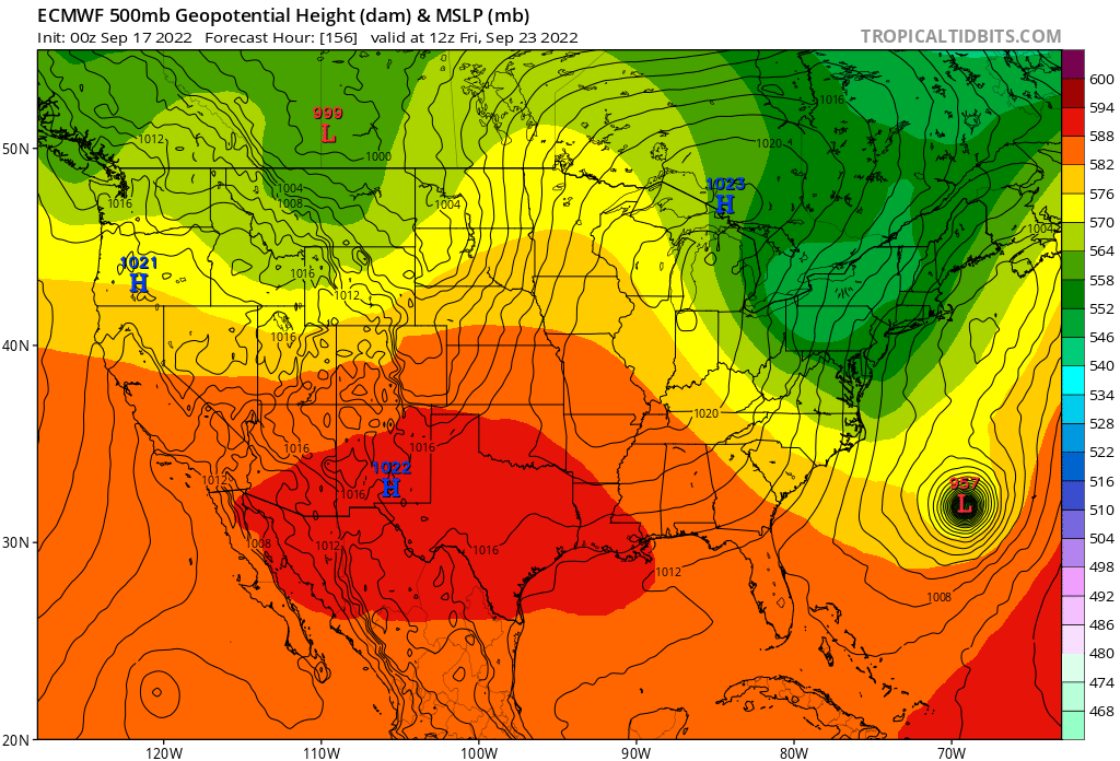
The latest euro runs are just the next iteration of the pattern evolution we have seen over the past month. At a synoptic level, you have to benchmark this system accordingly. Sure it could end up quite different, but this makes the most sense right now; minus all the details. The EPS shows the UL trough interaction by day 5, so a key feature is within model accuracy view
-

2022 Atlantic Hurricane season
jbenedet replied to StormchaserChuck!'s topic in Tropical Headquarters
Yes. Of course. Basically all I'm saying is, given persistence and the synoptic scale players Downeast ME and Cape cod, are a lot more interesting (right now) than Southern Florida or the Gulf of Mexico. -
2022 Atlantic Hurricane season
jbenedet replied to StormchaserChuck!'s topic in Tropical Headquarters
Early thoughts... Pretty damn interesting seeing track of Earl, then Fiona, and what will likely be Gaston/Hermine in coming days. With each storm, seeing a significant shift south/west, Persistence and the teleconnections both favor deep upper level troughs over the eastern CONUS over the next 10 days. With this, I anticipate Gaston/Hermine will be an east coast threat vs a GULF of Mexico threat. Earl passed northwest of PR, Fiona, over eastern Hispaniola, Gaston/Hermine over eastern Cuba? Fill in the rest. -
Held up really well. Sped up and made the right turn fast. Watch out Bermuda...
-
18z yesterday run. Error of ~75 miles in 12 hrs? Pretty damn bad, especially how tight the clustering is, lending high confidence to any meteorologist focused on this output. We have seen this degree of error before. I believe the short term confidence is where we a really struggling in terms of these forecasts.
-
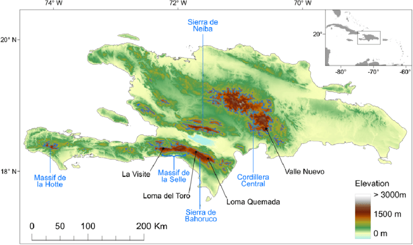
Fiona having significant land interaction with Hispaniola—something that all major guidance missed 24 hrs ago. The impending dissipation now means higher than usual short term uncertainty on track. Just the proximity of the 6,000 ft + mountains over central Hispaniola will do much to disrupt the mesoscale vectors funneling into Fiona’s surface circulation over next 6-10 hrs. Bold forecast to have this as a hurricane in 12 hrs. I think 75/25 we see downgrade to TS before re-emerging.
-
The closeness in time of the first trough means it’s well enough resolved to see that the orientation is too far east; despite being deep, it becomes an NS—east story. Now if Fiona stays weak and meanders in the Bahamas, missing the D6 trough, the east coast is open to a hit seeing the WAR that builds over top. The D10 long wave pattern is pretty damn standard look for a hit/very close approach of a tropical system, whereas D6 pattern is “not a chance”. Bottom line is Fiona needs to miss the D6 trough or we are all spectators for NS and NL. If not, very exciting to track—many “in the game”. Now short term- The land interaction with PR and Hispaniola is adding significant complexity to the short term intensity guidance and therefore the ultimate track. Weak = south/west; strong =north/east. Model guidance is classically conveying too much certainty with respect to this and many tracking are falling for it.