jbenedet
-
Posts
7,815 -
Joined
-
Last visited
Content Type
Profiles
Blogs
Forums
American Weather
Media Demo
Store
Gallery
Everything posted by jbenedet
-
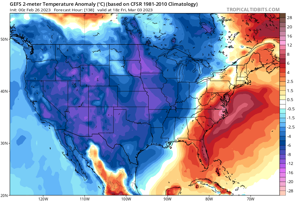
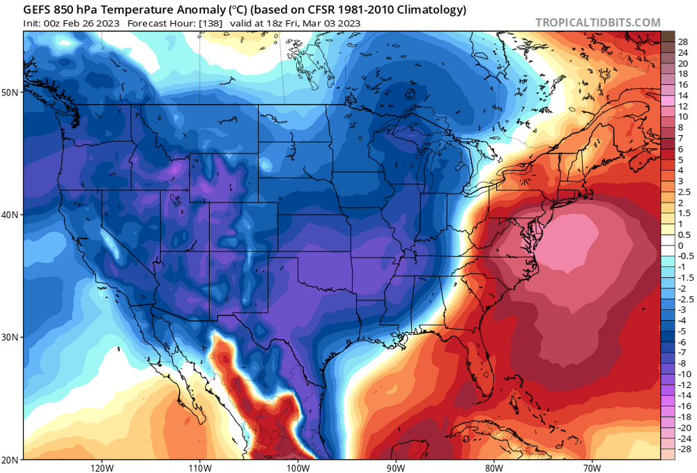
 This one will be fun to watch because it’s going to be in absolute beast mode by the time it hits Texas. I think even the GFS guidance is conservative with the early intensity of the surface reflection. MJO firmly in phase 7 with the way the pacific has been this year?! We’re looking at a system that will strongly influence the downstream upper air environment —WARM. So you’re going to need very well timed blocking or staunch blocking. We don’t have the latter. But with the -NAO chances are we could score the former. For now, my forecast bias is still strongly tilted towards a warm outcome given the way the Pacific floodgates are open and we don’t have antecedent cold over the northeast US or southeast Canada.
 -
I don’t like this one for snow chances for 90% of us. A 975 mb low will laugh at confluence that is not accompanied by surface cold anomalies. Looks quite warm out ahead. All cold behind—it will want to gain significant latitude. First guess is I think VT and upstate NY in good spot, as are far interior of NH and Maine. Mainly rain elsewhere.

-
Feb 28th-March 1st long duration Miller B threat
jbenedet replied to George001's topic in New England
I thought places that haven’t seen in inch all season would be thrilled at the prospect of 5. The euro is not pretty but it will spell a positive surprise somewhere in CT, with like 8”, a la 12/12/22. Take it and run with it. -
Feb 28th-March 1st long duration Miller B threat
jbenedet replied to George001's topic in New England

-
Feb 28th-March 1st long duration Miller B threat
jbenedet replied to George001's topic in New England
I mean, I get that. You’re talking 988 type low at the high end. It’s capped but at a slightly higher level imo, than the alternative. I just think more can go right, with a legit miller B, and much more can go wrong with a SWFE given the players. -
Feb 28th-March 1st long duration Miller B threat
jbenedet replied to George001's topic in New England
I see a hybrid (late bloomer) in EPS and UK. GFS mostly SWFE. ukie most miller B like, GFS least, EPS in between -
Feb 28th-March 1st long duration Miller B threat
jbenedet replied to George001's topic in New England
When the NAO is this negative, and flow is slow, I say let cyclogenesis work its magic off the east coast strong vort be damned. You’re more likely to get positive surprises than negative, so long as temps are supportive. -
Feb 28th-March 1st long duration Miller B threat
jbenedet replied to George001's topic in New England
Yea that’s what’s getting it twisted—an us vs them scenario. NNE wants a SWFE (primary holds on indefinitely) whereas SNE and north Mid Atlantic want a legit Miller B. The snowfall outcome is very much capped (everywhere) at moderate scale outside of an outcome that results in a weak primary that quickly transfers to Del Marva and then phases with the Northern Stream Shortwave, somewhere south of the Cape. -
Feb 28th-March 1st long duration Miller B threat
jbenedet replied to George001's topic in New England
Again. Similarities to 12/12/22 -
Feb 28th-March 1st long duration Miller B threat
jbenedet replied to George001's topic in New England
I still believe the prevailing issue is the shortwave over Manitoba. There’s theories on what would help bring back a stronger storm—why not just look at the earlier runs which were outputting such solutions? What was the biggest change? The late phasing of the primary, which causes it to hang on later, and diffusing chance of a clean phase with the coastal. To my mind if you dampen this feature, and the primary fizzles sooner, you can get a dynamic cyclogensis —even with weak UL forcing—to occur given the slow flow over the western Atlantic. This wouldn’t be great for everyone of course, but it would give much higher totals to SNE and northern Mid Atlantic.
-
Feb 28th-March 1st long duration Miller B threat
jbenedet replied to George001's topic in New England
This reminds me a lot of the December 12 event. A more potent version. -
Feb 28th-March 1st long duration Miller B threat
jbenedet replied to George001's topic in New England
The 6z EPS makes much more sense to me than the 12z GEFS. The GEFS is phase happy with the shortwave over Manitoba. But it could be correct. The result is much less clean; energy broadened rather than consolidated. QPF expectations should be 1/4 - 1/2 of the EPS-eque evolution. This shortwave out of a data sparce region is definitely adding to uncertainty. Am very curious to see EPS at 12z. -
Freezing drizzle
-
Feb 28th-March 1st long duration Miller B threat
jbenedet replied to George001's topic in New England
If the deepest cold was advecting from the northern plains and central Canada behind it, I'd agree with your concerns - the primary will want to hang on, and bend back. But the airmass behind it is relatively quite warm. -
Feb 28th-March 1st long duration Miller B threat
jbenedet replied to George001's topic in New England
I can see that. I mean when it comes to the wave inhibiting strength of confluence I try to focus on where the deepest (relative) cold anomalies are. If they are collocated with the confluence, out ahead of the amplifying wave--and within the sphere of its would-be warm sector-- that's a pretty damn good indication it will not be able to bend north, in the face of it, and quickly concede to an earlier secondary. This of course is conditional that the confluence is anchored, which is what we are looking at in this case, with a strong -NAO developing. -
Feb 28th-March 1st long duration Miller B threat
jbenedet replied to George001's topic in New England
That's a good point. Possible though currently unlikely. But if what I believe to be a trend of Stronger block-->slower trajectory, that would increase the odds quite a bit vs the current guidance consensus on that aspect. Point of interest highest for eastern locations. -
Feb 28th-March 1st long duration Miller B threat
jbenedet replied to George001's topic in New England
Some members with much less blocking? I mean, they are possible, but I don't see any reason to buy into those at the moment, given the trends and forecast teleconnections. That's just me. Then there are others that show more, hence the mean, with E trajectory.
-
Feb 28th-March 1st long duration Miller B threat
jbenedet replied to George001's topic in New England
We'll see. I believe this one will spread the love, "so to speak". Hit the areas hardest who have seen the worst snowfall deficits. I strongly doubt a persistence outcome. The significant -NAO alone says this event is quite different than the recent past, at least going back to mid December. -
Feb 28th-March 1st long duration Miller B threat
jbenedet replied to George001's topic in New England
Yea that's the bite of this for Pike North. I mean there's no curling (bending back) as it hits the Atlantic, the strength of the block increases greatly from that point. -
Feb 28th-March 1st long duration Miller B threat
jbenedet replied to George001's topic in New England
That's a sig block incoming, peaking right around this storm's closest approach. Strongest -NAO we have seen all season. Great for coastal SNE and Northern Mid Atlantic. Too much of a good thing for the northern folks, is my take. -
Feb 28th-March 1st long duration Miller B threat
jbenedet replied to George001's topic in New England
We haven’t seen a similar pattern to this since early to mid December. We had our little CT crusher during that timeframe, even with warm climo. -
Feb 28th-March 1st long duration Miller B threat
jbenedet replied to George001's topic in New England
12-18 is very much still on the table. I mean, don’t take my word for it, just read the GEFS and EPS verbatim. -
Feb 28th-March 1st long duration Miller B threat
jbenedet replied to George001's topic in New England
The guidance right now, looking at MJO and NAO forecasts, both point to strengthening the -NAO block up until go time. Maybe these are wrong…? But when I see EPS and GEFS following those forecasts, as I do now, I’m hedging in favor of a stronger block in 5 days than what is currently being shown across guidance. -
Feb 28th-March 1st long duration Miller B threat
jbenedet replied to George001's topic in New England
By CNE you mean pike north to NH/VT border? If that’s the case I think you’re going to see a sharp west/east gradient in CNE. Higher amounts west, Lower amounts east. I like NJ and LI better than most of CNE for this one. And def better than NNE. At least right now. -
Feb 28th-March 1st long duration Miller B threat
jbenedet replied to George001's topic in New England
My *current* take on heavy snow probs. SNE > N Mid Atlantic > NNE