jbenedet
-
Posts
7,800 -
Joined
-
Last visited
Content Type
Profiles
Blogs
Forums
American Weather
Media Demo
Store
Gallery
Everything posted by jbenedet
-

July has arrived ... the Meteorologically defined mid summer month
jbenedet replied to Typhoon Tip's topic in New England
Finally will get our desired long wave winter pattern.... in late July... -
July has arrived ... the Meteorologically defined mid summer month
jbenedet replied to Typhoon Tip's topic in New England
Indeed. No joke. Vatican is in the plans. -
July has arrived ... the Meteorologically defined mid summer month
jbenedet replied to Typhoon Tip's topic in New England
Sweet. Just in time for my trip. Leaving this evening from Logan. The beaches at amalfi coast will be a real win with SST's right around 80. But Rome, and Florence ooof. Torch. Lake Como should be great with the microclimate of the 70F lake. I'm taking it that the destinations near water will be wins, while everything else a big loss. The 100+ readings are that much more remarkable given it's a peninsula with non-tropical SST's. I guess it will be cool(ish) to experience the all-time records... -
I wish I'd see those around here. Great way to keep mosquito populations in check. And they're cute little critters.
-
Weekend looks like a washout for most. sunrise will probably bring some optimism on both sat and Sunday but that will quickly fade as day time heating kicks in and lapse rates steepen. And where the rain and clouds are less persistent, further south and east: rain, then the sun will poke and subsequently fill in with next downpour or —at best—heavy cloud cover. Too much UL divergence over our heads in met summer. Theres also a meso 300 mb jet streak along the cape and islands so that might be what’s triggering the euro with higher qpf amounts down that way. Prepare accordingly.
-
May obs/discussion thread - Welcome to Severe Season!!
jbenedet replied to weatherwiz's topic in New England
It’s obviously too far out for details but there’s been pretty remarkable consistency across the GEFS and EPS for much worse weather and a sig disturbance centered around the mid Atlantic, coinciding with Friday to Sunday window. And so, likewise, for our subforum—>odds currently favor much better weather north, especially relative to climo. Looking around, observationally, the persistent exceptional dryness, portends a “clash of air masses”, fueling baroclinicty, if you will, as we head into unofficial summer. This makes me believe a subtropical disturbance type outcome as advertised on the 6z GFS has greater plausibility than we normally can assign this far out. It could still flip, but odds are high enough in the mid Atlantic that I’m about pull the trigger on cancelling a trip to eastern Long Island and instead enjoy the long weekend around here with some day trips into Maine. -
May obs/discussion thread - Welcome to Severe Season!!
jbenedet replied to weatherwiz's topic in New England
It’s a perfect afternoon. CoC Full leaf out this weekend. -
May obs/discussion thread - Welcome to Severe Season!!
jbenedet replied to weatherwiz's topic in New England
Decent day on tap. 60 in view. -
We 60 yesterday; we 70 today. Take ‘em up. Classic best weather preceding the worst of weather. The anomalous surface high responsible for it all.
-
DAW 59 and partly cloudy as of 12:50. Couple more hours of heating to go. Best day in a while. Low bar. Sad but true.
-
Selling the globals here today. I believe we 60 and sun in SE NH outside of 95. A small victory but it’s all we got.
-
As “decent” as you get around here for the calendar. Occasional break of sun but mostly mid level overcast. 54 for a high will probably do it. Couple degrees BN. Light wind. Sweatshirt is good enough for walking the dog. Looking forward to some heat and humidity. Everything looks tired of the dryness.
-
The back door presses to the northern mid Atlantic tonight, and then recedes back towards CNE by tomorrow morning. I’m very skeptical of the latter part— the teles and seasonality argue for a “best in Maine” setup on Saturday. It’s a pretty classic setup for miserable weather in coastal northern mid Atlantic. I think the door presses South all day today then stalls somewhere around LI tonight and remains there most of Saturday. Saturday has a much better chance of being a shit day to the northern Jersey shore than 70. With that I still think Saturday turns out “decent” up here, but we are definitely running out of time, guidance wise.
-
Usually coastal front here means shit weather through June 1st. But this is San Fran this afternoon. Pretty perfect analogy given how torched the atmosphere is just above the surface on up, with very cold SST’s. Nearby Portland Maine can attain this on the regular but not until late June. 70 with a light to moderate breeze and full sun. Fantastic. You guys can keep the record heat.
-
DAW will finish near euro's numbers. Beautiful out.
-
Temp is about to rip here. South wind fanning now. 30 min we clear out.
-
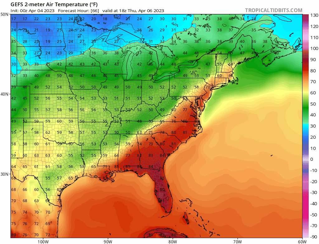
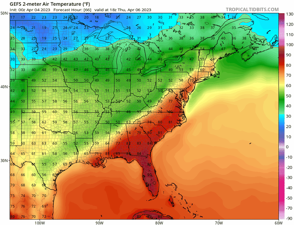
Morning temps have literally nothing to do with the high temps in this. ISR - it's a high order exponential function today. Either you clear out or you don't. 35 or 45 will still translate to 70ish because of what's just above our heads. Temps below consensus in the morning and then catching up and exceeding guidance in the afternoon is exactly what you'd expect given the known guidance biases in both directions. If most in SNE are still socked in by 12, then the warm breakout is a bust. But latest satellite already shows the dank eroding, broadly, so that's still the bad bet.
-
For those with snow still on the ground - flip a coin?. But for the rest of us, I’ll take the odds that this is our warmest day since October.
-
It does given what we're experiencing today, and our climo. But that 1040 canadian high fizzles overnight and is gone by early tomorrow morning, across guidance. It ultimately gives way to a bermuda high by early afternoon. I mean, all we need is the slightest southerly fetch to get there, given how cooked it is just above the surface. And that's what guidance is showing. If there was any semblance of a surface high up in southern QC by 12z tomorrow, I'd say hard sell. But this is lookin' solid.
-
Let's goooooo
-
GFS - now warmest of guidance? Lock it in. GFS won with last weekend's cold tuck that stuck. GFS cave = confirmation that we cook.
-
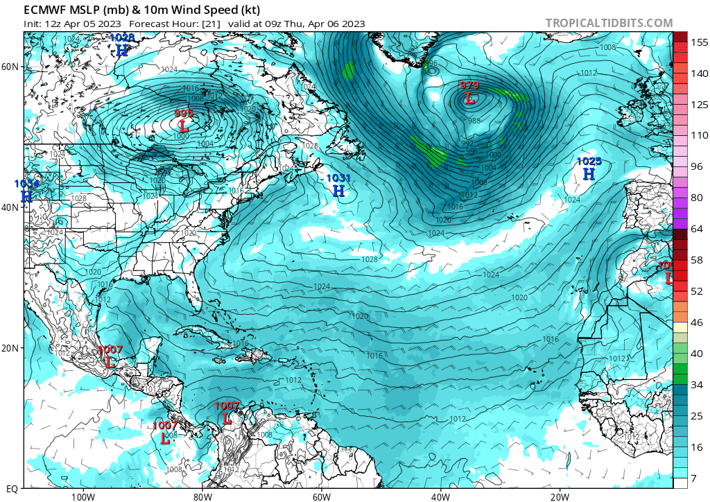
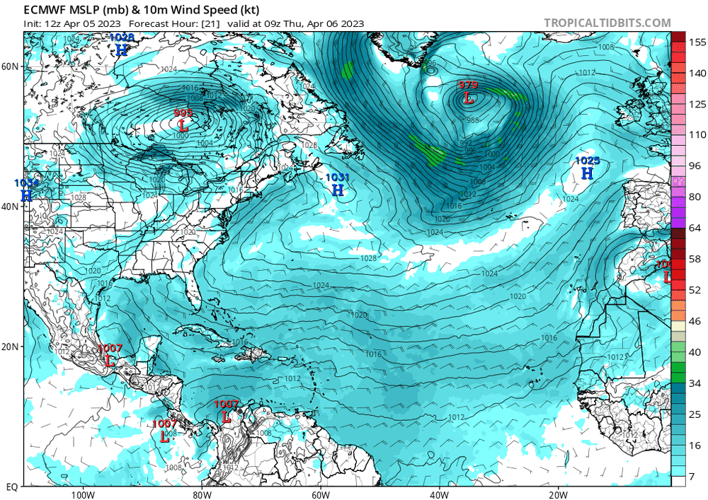
It’s gonna Tip. Wed will suck but by Thurs, The surface high is fleeting and it’s filling with pacific air. Doesn’t stand a chance; even with all the seasonal caveats. We cook. Bet on it. The EPS and GEFS are also all around WARM by Thurs afternoon. Any Canadian highs long gone…
-
Believe this will be my first winter season here, November through April, each month with below average snowfall.
-
Put some of the hardy outdoor plants back out yesterday morning. They were tired and showing the stress of 4 months indoors, as it was. Wife still thought I was nuts with the snow/sleet fallin’ in the early afternoon. But white rain prevails. 36 for a low. Sun out and a 50F day on tap. Might have to take ‘em in one or two more nights before all clear, but this has been the most seasonal progression since my move in 2015. Steady as she goes—winter gave way to spring right with the calendar, but without any big warm-up. We are springin’ New England style.
-
Cold rains. This -NAO is not gonna produce for the vast majority with the pacific as bad as it is. The snowpack in far interior NNE, Maine and SE canada, just reinforces the blocking in the east, and precludes warm sectors for the rest of us down to the Northern Mid Atlantic. Oof. Weather that makes you wanna move.