jbenedet
-
Posts
7,815 -
Joined
-
Last visited
Content Type
Profiles
Blogs
Forums
American Weather
Media Demo
Store
Gallery
Everything posted by jbenedet
-
850's are very warm throughout. Dews and surface temps are supportive for frozen. I think the reality is this is a pelt fest in most areas in subforum, where the qpf is > 0.1". The dynamic forcing is in the base of the H5 trough, which cuts off over the southern Mid Atlantic. It's an interesting look--snow-wise-- for that crew. Best to not get roped in up here, unless sleet is your thing.
-
It's actually really warm out ahead of the front. 50 in Rochester NY last hour. Evening highs on deck before the peltfest?
-
You didn't see anything.
-
Nice catch. Cursory looks have their pitfalls. 925 for the loss
-
It's peculiar for sure. It's like the climo surface cold tucks we get are being over-modeled at every opportunity this year, and by a large margin.
-
Nah man. Just calling a spade a spade. Literally a ratter is N to BN when there are no storm threats, and AN when there are storms. That is it. Don't make it complicated.
-
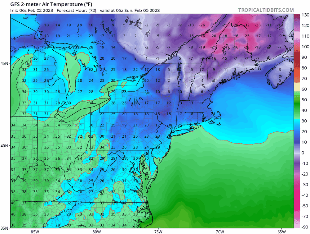
I was just doing a cursory check of the temp guidance for highs today - AGAIN looks really low vs 850 temps, and no surface CAD and lots of sun until afternoon. What gives? 33 for a high at PSM ??? 40 seems pretty damn doable. 42 makes more sense to me than 33.
-
Did I meh this already? Those single digits are way up an in. By and large pretty close to normal by the looks of it. PSM: 34/16 normal high/low. Bottomed out at 21 at PSM; 21 even up to DAW.
-
Meh. It’s bottled up north and heading east. Western upstate NY says “what cold”. Normal low here. Normal high on tap.
-
Pretty sure that’s just the definition of a ratter. Some call it an odd winter; others call it a rat.
-
This logic... Then how do most areas in an around Presque isle have 20" or less on the ground? Sublimation. Compaction. And much less so - melting. If it's not snowing, your pack is decreasing in size. Pretty simple. Anyway. Throw a ratio out there - it's a lot higher than 50%.
-
150 miles north for every 1000 ft in elevation. Figure 75 miles in your case, correcting for altitude. Conservatively, you're more like 100 miles north of PSM. And that only puts us on the same plane; doesn't account for the ocean affects. Yea, in short, it's a huge difference in climate... I have had more non-frozen precip than frozen this season. And I'm in Dover. Portsmouth is like 15/85, frozen/liquid; whereas you have been more like 85/15 frozen/liquid season to date. And most of that for you is snow.
-
It really is. 40 miles. But you also have 1000ft elevation, right?
-
<45F and rain does suck; but 45F sun, with no wind is pleasant in February. Just find your spot in the sun and the real feel is 10 degrees warmer. Yesterday with a high of 48 was one of those days. Lots of sun and no wind, fully compensated for the temp and dry dews. I will take. 45-55F winds and sun make or break it. Today is also decent. Was just outside with a fleece and hat. Perfect in the sun.
-
Temp just spiked here. Beautiful afternoon. Mostly sunny. Short term Forecast/guidance temps busting way low. Again. Shocker.
-
Basically waking up to a normal morning temp wise. Arctic air booted. SW winds. Nice. A little bit of sun will go a long way today. Guidance today overplaying the clouds in SNE again it seems. Looks like more sun than clouds all day, and with 850’s cooked, even SE NH will flirt with 50.
-
You are the far interior of NNE. No.
-
Recency bias. When this cold disappears tomorrow they’ll be back to bitchin’ about a rat winter.
-
No. The snow pack line gets beat back to the far interior. That is the far interior. They will maintain a pack, of course. The rest go brown. Thanks for seeing the same.
-
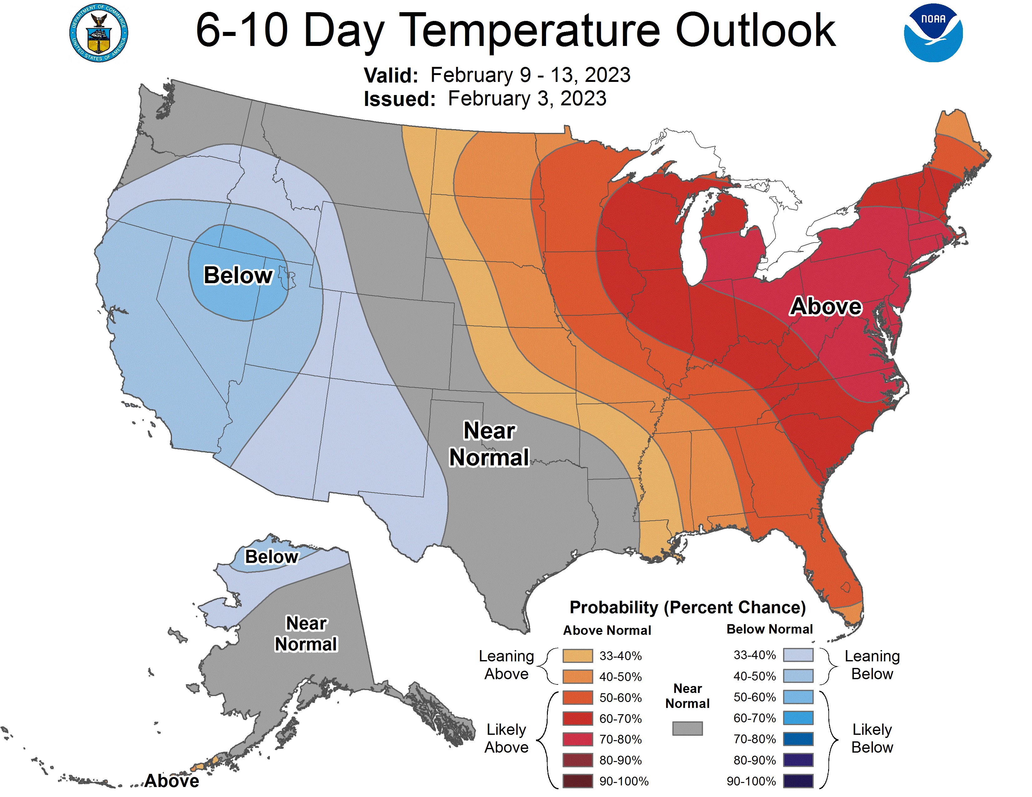
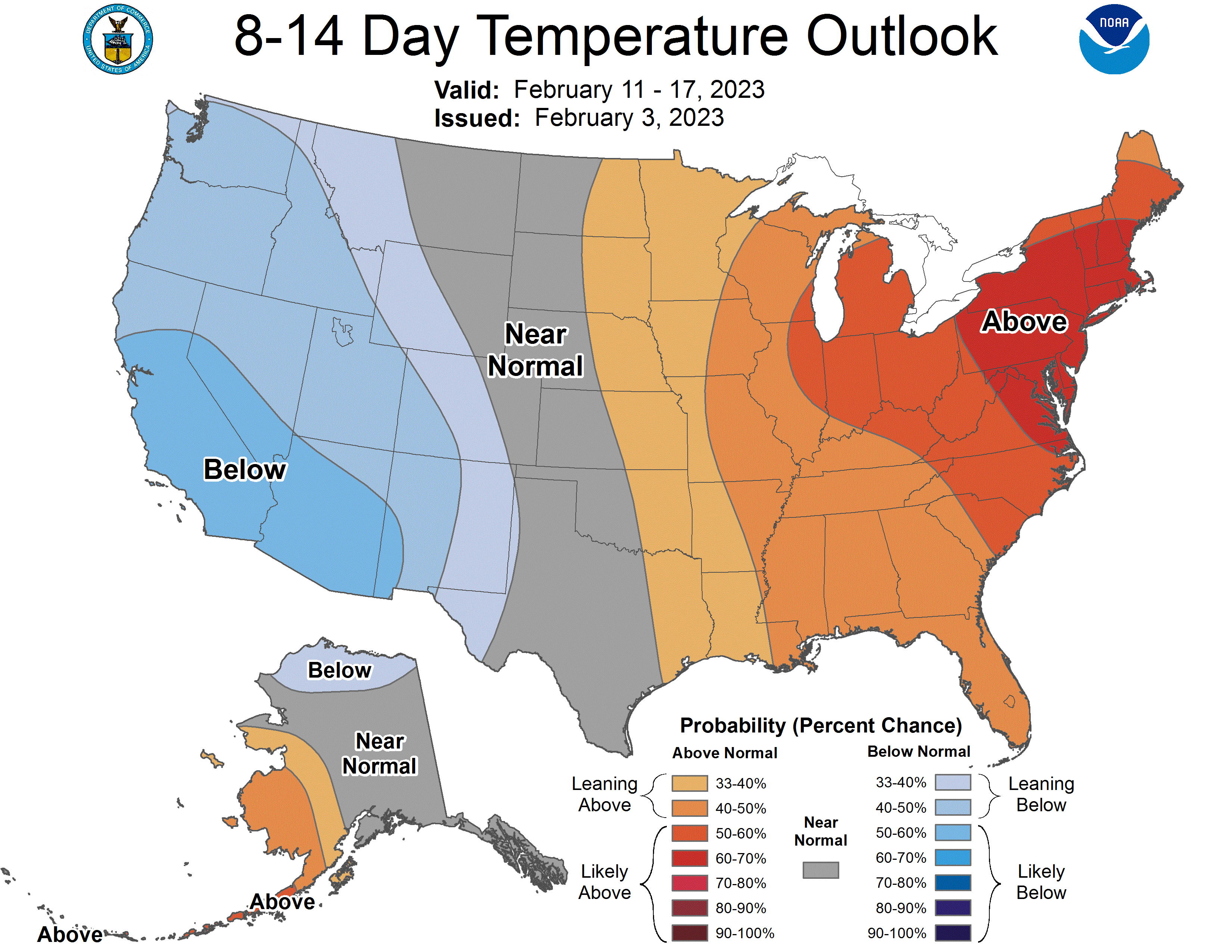
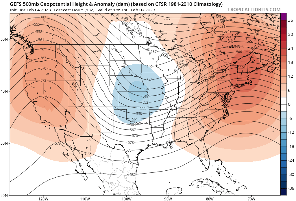
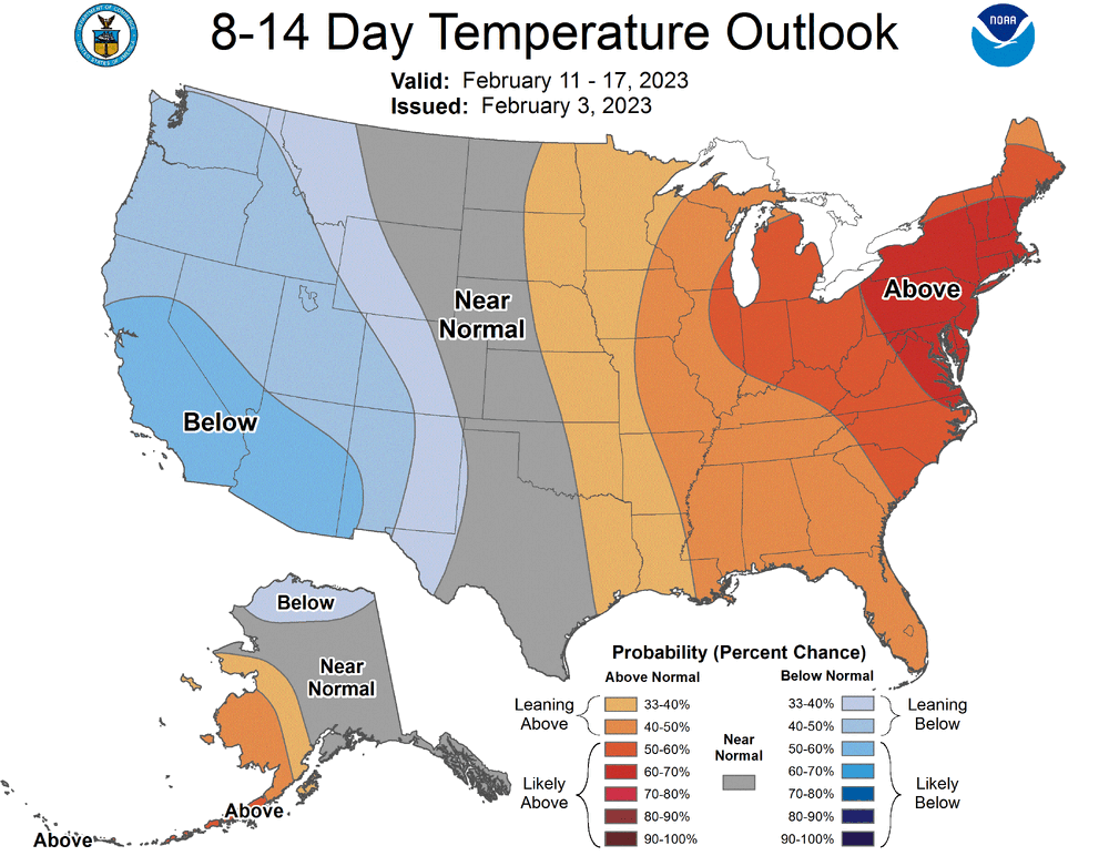
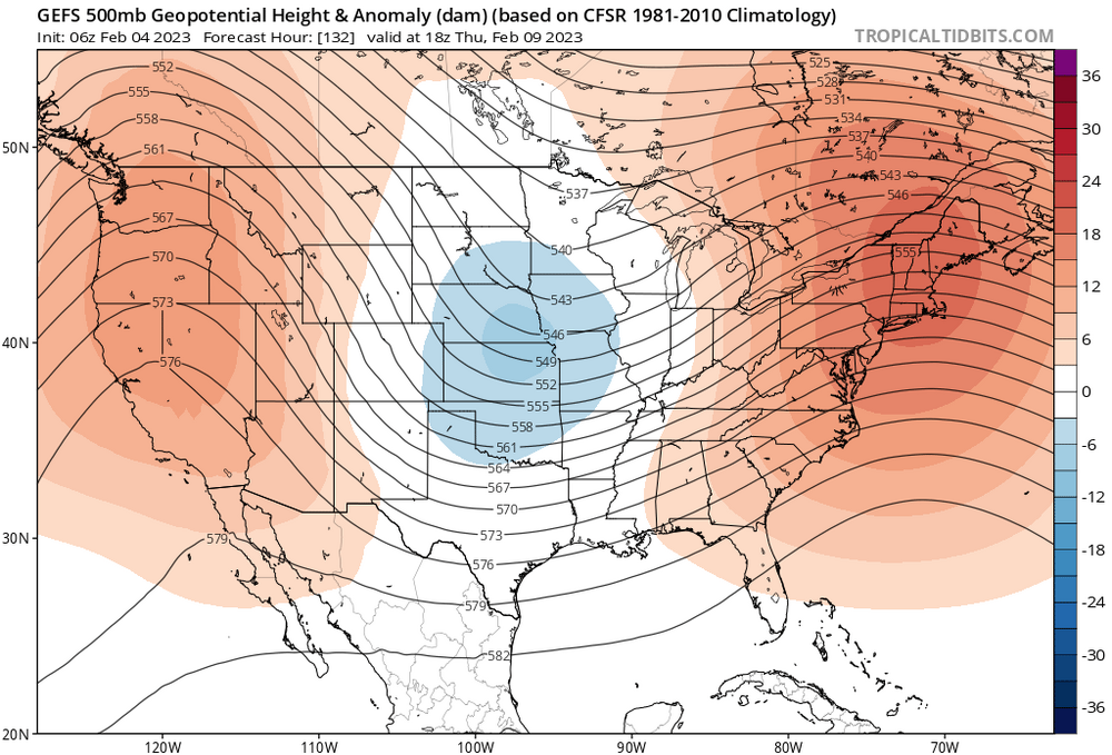
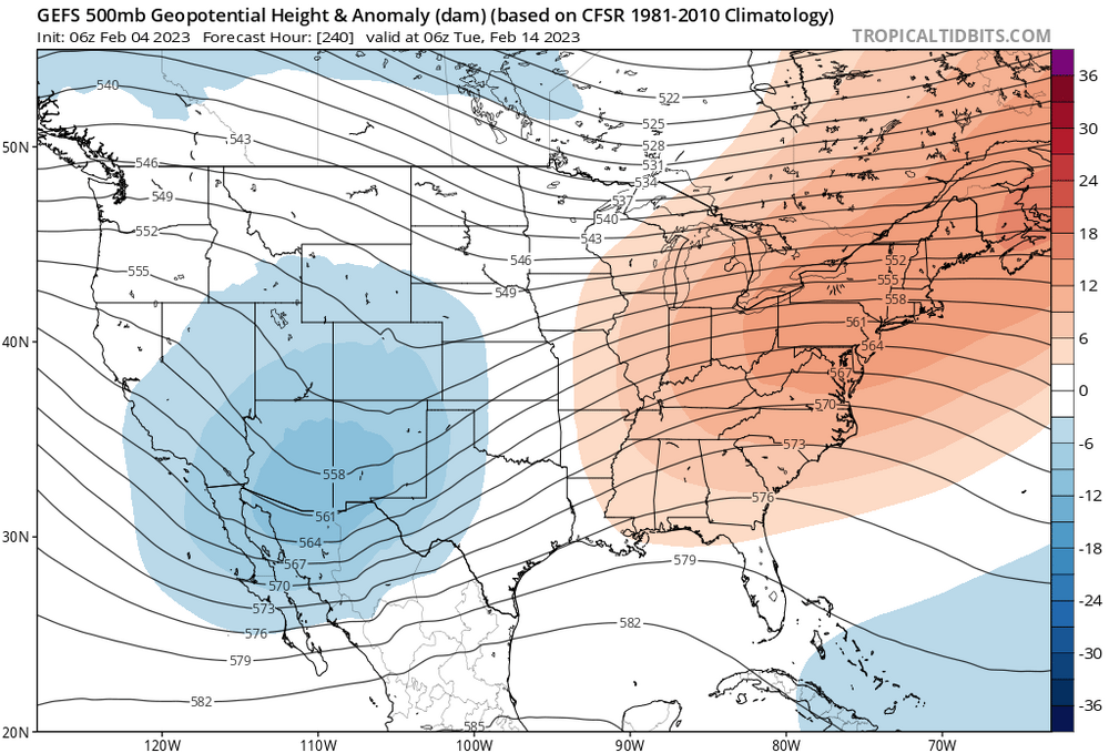
Pack going to get beatin’ back to the far interior of NNE, over next 10 days. Everything looks warm; teles, MJO, GEFS and CPC saying the same,

-
Yea you aren’t sure. None of us are. And even where there is sound scientific theory, you should still never be “sure”. There is always uncertainty. But that doesn’t mean you cannot postulate. We can’t break it down empirically—at least not yet—, but my point is rooted in basic Newtonian physics: nature abhors a vacuum. Or for every action there is an equal and opposite reaction. That mean reversion many were calling for, imo, happened all at once, and without a storm. Now work from that basis.
-
Today is going to feel pleasant compared to yesterday. Single digits to low teens but no wind by afternoon. That’s a 40F gain in real feel. Heh.
-
This doesn’t portend well for snow chances, going forward, in my view. The cold blows it’s load all at once. Unlikely we will see it when we need it; at least for a while.
-
Thinking extreme cold/dry (density) translates to higher wind force at the same speed; it’s always factored, but most often negligible. In this case, non-negligible—perhaps 5-10 mph added to reported wind/gusts vs average winter airmass…?
-
Take em up Saturday afternoon.