jbenedet
-
Posts
7,815 -
Joined
-
Last visited
Content Type
Profiles
Blogs
Forums
American Weather
Media Demo
Store
Gallery
Everything posted by jbenedet
-
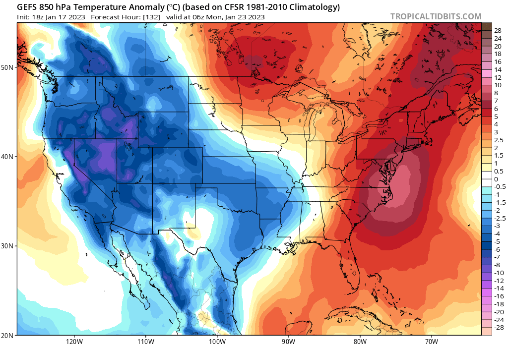
 For all the talk of poor antecedent airmass. … Not really. Low level CAD begins begins tonight, on northwest winds, so we get a fresh injection of low 20 dews.
 -
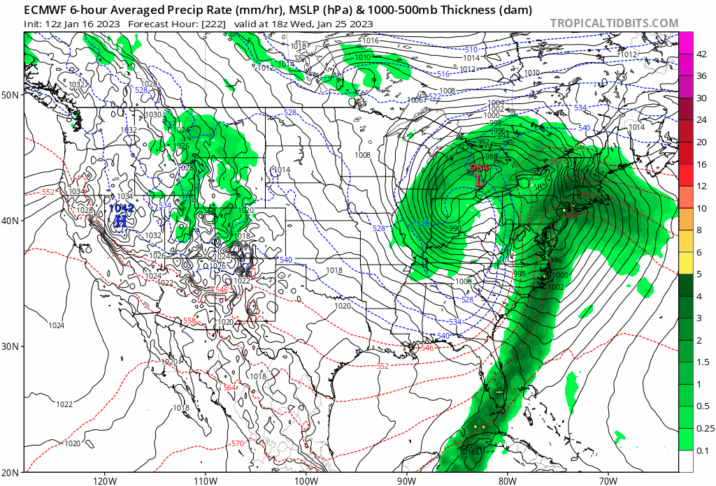
The 6z EPS pops the secondary about 3-6 hours earlier than the 12zNAM. If we take the EPS run verbatim and shift 12zNAM 850 thermals accordingly, the risk is asymmetrically tilted in favor of more snow where 850 is the warm layer, and surface sufficiently cold. Worcester west/North, line for example. Could be talking a few more inches than the clowns advertise. We watch.
-
Wine.
-
Crooklynwx selling more snow weenie H5 maps. The snow addicts in SNE can’t resist. This Monday threat looks like shit under the hood. Someone create a Back to brown thread for this shit.


-
Noted. Yes that area. Cheshire, Florida, Williamston, New ashford.
-
I'm going with a jackpot in the Berks on this one. North Adams area.
-
The NAM clearly feeling the cold press in the primary --more than other guidance--but the primary holds on much longer (longitude) than other reliable guidance. Net-Net it's a warmer depiction because SNE skunked at 850. But being that the NAM is alone in this aspect, we sell for now... This is one of those where you have to smell the taint to get the highest totals... Cold tucks are significantly under-performing broadly this season, and I'm selling any of them advertised in the east until further notice. But we have seen them show up with stubbornness in the far interior, so I believe this is can be one of those situations.
-
For Thurs/Fri, The EPS has been trending positively for a more wintry solution in the marginal zones. Weaker primary, less latitude gain, earlier secondary.
-
We have a well-timed weak cold front with respect to Thurs/Friday threat. I really struggle to see these COLD dews bottled up in Southern Ontario. Yes, even this year. The relative position of the core of the cold over top of the primary should also aid in inhibiting latitude gain. This looks like a classic CAD wedge signal down the western side of the Apps into Northern Virginia. I say shave 5-10 off these dews at this hr. from Albany, VT, west MA down to Western Virginia.
-
C'mon @MJO812 , you don't even need an imagination for this one. I just realized this looking through the posts above, but the 12z Euro.... This doesn't look familiar???
-
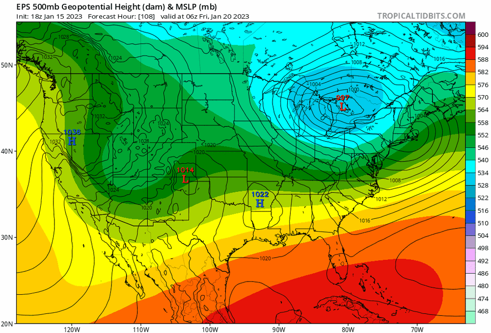
This look around day 9/10 reminds me a lot of the Arctic blast in December and the prelude to the Buffalo bomb. Not a good look for us easterners.
-
Yea I def see that risk, but there isn't a low level WAA signal either. So my thinking is areas west with dews around freezing can quickly cool the column within few hours of precip onset. Which again is why this isn't an ice threat - more of a rain/snow deal.
-
I'll take the 12z EPS for Thurs./Friday and run with that. I think western MA/NW CT can work with this. Thursday, it looks a setup where surface temps will stagnate all day near the morning low out there.
-
True. I'm just looking at onset across guidance- surface dews are 30-32 in western MA, while northeast MA, mid 30's. And given climo and the wind direction, I'd hedge higher on those, east, and lower on those out west.
-
This is too N/S to me. I think this gradient gets tilted more SW to NE; rotate the axis a bit. There's an easterly fetch off the Atlantic which i think it gonna hurt eastern areas up until redevelopment. At the same time, low level WAA is non-existent out in southwestern sections, so in-situ sub-freezing dews will stay in place and aid wet bulbing marginal temps. If 850's are stubborn, the axis I'm alluding to would probably manifest in ice/sleet instead of plain rain. Looking at NW CT, Western MA.
-
lol, just realized it's colder by like 3 - 4 degrees 50+ miles to southwest, over around ORH. And that's vs DAW, which is away from the coastal plain. What a strange system.
-
Is it still adding up? DAW is up to 34, now so we're seeing compaction/melting etc. The heavy band that moved through earlier won't even require a car clean; just wet. After sunrise, been mostly a wash today in terms of further accums
-
Yea the UL trough is pretty energetic across guidance - so I believe chances favor continued light snow until it swings through.
-
Verbatim that's like 36 hrs of snow in the Berks Greens and Monads. There's def upside risk in long duration with this. Guidance continuing to show the possibility. Mostly of the light variety but nice in any season.
-
Mehhing our way to the best snow threat for the subforum this season. It's a low bar, I know; but solid look at day 4. We take.
-
I'm seeing it the opposite. This week is an outside week. First seen with the coastal, and then Thurs./Fri with weak confluence in the Northeast and SE Canada. MJO phase 1/8 is flexing, despite the poor long wave pattern. But this is transient. Pattern is back open to UL ridging all along the east coast by next weekend.
-
For Thurs/Fri, I believe down to the southern Berks is very much in this one. Another case of a weak cold tuck that is displaced west and most pronounced well inland. This aspect will probably surprise to the cold-side. At the same time I could see ORH east having p-type issues until way end.
-
yea definitely. I also believe the combination of showery precip with temps oscillating above freezing further worsened the issue. Persistent Moderate rates in banding would sufficiently cool the column, with Td’s where they are; but once rates diminish surface temps creep back above freezing, melting ensues, until the next shower moves in.
-
Lol 37/-1 at PSM No wonder haven’t seen a flake.
-
Yea once again: for most it’s a lot of snow obs with very little to show for it on the ground. Mid coast to DE Maine maybe cashes in with 6”+ but I haven’t looked at it in any detail to wager one way or the other.