PivotPoint
-
Posts
714 -
Joined
-
Last visited
Content Type
Profiles
Blogs
Forums
American Weather
Media Demo
Store
Gallery
Everything posted by PivotPoint
-
MLK Weekend Event - Making Lemonade Out of Lemons
PivotPoint replied to Bob Chill's topic in Mid Atlantic
The previous event is top 3 in my book for last 10 years. Just because it literally snowed Saturday, Sunday, Monday from the same storm. And Sunday afternoon for those who kept the faith were then rewarded when the radar lit back up and it just dumped for like 6 more hours. Awesome event -
MLK Weekend Event - Making Lemonade Out of Lemons
PivotPoint replied to Bob Chill's topic in Mid Atlantic
Yea, what is he seeing as more north. Came in slightly weaker which is probably good for us. Not great for NY/VT snows -
MLK Weekend Event - Making Lemonade Out of Lemons
PivotPoint replied to Bob Chill's topic in Mid Atlantic
It won't imo It's not great with handling these type of backend setups typically. A ) they rarely work out anyway B ) when they do, it's almost always now-cast scenario -
MLK Weekend Event - Making Lemonade Out of Lemons
PivotPoint replied to Bob Chill's topic in Mid Atlantic
Interesting enough my point and click on NWS has Sunday changing from rain to wintry mix. I guess they are putting some weight behind a quick flip at the end. We'll see how that plays out -
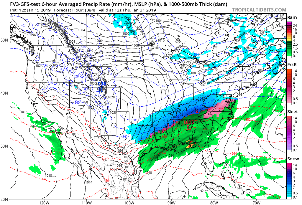
We’ll probably lose the 84hr look but I do like idea of a more progressive SS that misses the timing with NS. Allows for a front end thump. I know the NAM lacks skill with the timing at longer leads but someone posted earlier that the euro has trended with a flatter and more northerly NS the last three runs in a row. There’s still time to believe in a front end thump for NoVA. And I believe the latest GEFS has the weekend low clusters a little south of the op too. But I could be mistaken, didn’t look
-
12z nam says it probably ain’t happening. Sped up and more interaction with NS. That was a quick glimmer. Was hoping to get to happy hour namming
-
Wow, that’s a huge compliment. I feel honored, no bs! I’ve read yours and psu’s and other really good posters on here for years. I started back in the Eastern weather forum days before the conversion. Never spoke cause I had no clue what to say. Everything I’ve learned I’ve picked up from you guys. I know my analysis needs work and is more remedial in nature then yours and the other experience Mets, etc. but it’s nice to know it’s come full circle. I appreciate that. Means a lot to just another winter weather weenie hoping for a little snow in his life
-
Looking at today’s runs for the ops and ensembles I know pessimism is certainly understandable but here’s my take moving through end of January through early February: The WAR seems to be progressing on models to the NAO domain and flipping it negative towards the end of these runs. Been pretty consistent on GFS and seems like it’s heading that way on the euro. Having the AO flip very negative gives us an opportunity when it starts to relax. Some of our bigger events tend to come on the tail ends of big telleconnection changes (NAO flip, or AO, etc) If we can maintain some semblance of a split flow and a decently active SS, I really think we can see the first or 2nd week in February pop. I know there’s a lot of unknowns in my hypothetical but I really like that the AO flips strong and the NAO seemlying is going to do the same. Get through the cold suppressive period for a short time and hopefully there’s a nice surprise at the end of the tunnel.
-
Yup, I think .30 is good guess as to max potential. I just want to see snow on snow. I’ll take my measly inch before the deluge
-
18z gfs cold air wedged in a little better. Didn’t look at sounding but guess we lose mid levels as the low passes through the area. Could be a better trend. Would like to see the vort a little more vigorous like dipicted in the nam
-
Right, I’m not expecting any miracle solutions. PA north is definitely favored and borderline with 24th storm. But it would not surprise me if by this weekend we saw that 24th trending a little better based off the seasonality of recent forecasts. Could just be wishful thinking on my part too...
-
I will say looking at the ops past 24hrs I know they are showing some amped up solutions. Makes sense with the WAR, MJO, etc. However if you put any stock in seasonal trends (I put some) there appears to be a slightly favored disposition for models this season to under play confluence to the north in the long range. We’ve been cycling through these high pressures to our north pretty consistently this winter. So I wouldn’t rule out front end scenarios delivering a couple inches here and there until the WAR cycles up to the NAO domain and turns us negative (hopefully). Long and short of it is I wouldnt rule out any day 5+ ops showing all warm side precip which could changing slightly to our favor given a seasonal trend to over amplify these systems and models not truly recognize the strength of these highs till medium leads. 2 cents
-
My birthday storm!! It's coming

-
Good times. Well, I'm always game if you get a wild hair
-
You know your stuff, sir!
-
Perfect. Good stuff. Should have a great time
-
I'd say just suck it up and make the long drive to VT. It sucks but you won't be disappointed. You have a good 4wheel drive? I have a 4runner with dedicated snow tires during winter so I'm comfortable with the trip but know that it can get dicey REAL quick up there if you're not properly equipped. Just make sure you leave well ahead of the storm. I typically chase up there to go skiing and I've turned a 9 hour drive into a 14/15 hour drive before. That last 150 miles on rt 91 to 89 can be abysmal if you start to get slammed. My guess is you'd probably take 87 and go through upstate NY the direction you'd be coming from. Honestly, Id be heading up there this weekend if it weren't for a recurring Sunday commitment. Hit the slopes then grab a Heady Topper beer Apres Ski. Nothing better I'm hoping the storm after the storm holds together for the 1/24-26 time frame as I have plans to play hooky if that storm comes to fruition.
-
Lol Good points -- teaching is tough at that age. Just gotta be real simple with the ideas and language. Think big concepts and let him figure out the details. That's so awesome though you're taking him. Real cool age to learn cause they're like little gummbies and they fall down and get right back up lol. Not us old guys anymore. I'd say Smuggs is probably a little challenging terrain wise. But I'm sure they have terrain for him and if it's a good deal on a group lesson Id say go for it. The easiest (imo) and least intimidating mountain in Vermont is probably Mount Snow and they are very family friendly. Stowe's lift ticket is just too much but its got awesome terrain. Jay Peak is really cool but if its gonna be windy they usually shut stuff down as they seem to really feel the wind effects there. If you do go, I'd say try and stay around Burlington which is a cool little city with a lot to do. Then either drive to Smuggs or Sugarbush which are within about an hour of Burlington. There are some smaller mountains around Burlington but I haven't skied them. Anyways, have fun. Should be really good conditions this weekend. Take Pics!
-
Trust me, it will absolutely be windy. Anytime you get something that spins up that much its windy up there. But those mountains always half lifts that positioned for windy days. Just might not be able to get to the "goods" up top.
-
Go to Vermont man. Stowe is prime for 12-18" from this one. Sugarbush will probably be good spot too and little more friendly on the pass prices. Enjoy!!
-
If you look at its last 3 runs in a row it actually hasn’t jumped around a lot. Additionally, when the setup isn’t a complex low pressure evolution it does ok (imo) at mid 60hrs range. Albeit not as good as the globals. I still think it looks good and might be picking up on a colder trend with .5-1.5” for dc metro. I need my snow fix
-
12z icon looks a little better with stronger heights out in front of the low as it passes through on Thursday. Keeps cold in place a little longer. Not a huge net gain on the snowfall totals but an improvement none the less
-
I woke up one morning in Stowe Vermont either 3 or 4 years ago (can’t remember) and my 4Runner read -38 degrees. Coldest by far I’ve experienced and my runner sure didnt want to turn over. Took a few tries to get her warmed up to the idea
-
Yea 540 line little more sag to it. About the same result. We trend??
-
Anytime