PivotPoint
-
Posts
714 -
Joined
-
Last visited
Content Type
Profiles
Blogs
Forums
American Weather
Media Demo
Store
Gallery
Everything posted by PivotPoint
-
Fair enough fair enough
-
“Do as I say, not as I do.” Yes? What do you think of my early totals call? I have you in the 6-12” range for Wed’s storm
-
Keep the banter down guys.. we got a storm we’re tracking here!!
-
4/5 days ago when the pattern started to advertise itself I mentioned the PNA and ridging probably being the greatest key to this setup. We have a stout high in the correct spot but the airmass is still marginal given it’s early in the season. We need to amplification and a ridge out west that flattens or breakdown as our sw amps up will not produce for the cities. I still see this as a mix event at best for the most of dc metro and immediate suburbs. Winchester on west to Canaan Valley should do real nice. If the ridge axis and heights out west stay the course. Perfect ridge placement and I think the rest of the ingredients will be there in some form or another. Early call for weds storm is 2-6” with mix cutting totals and some melting around the city and Nova, 6-12” Winchester through Frederick MD, Baltimore 4-8”, then jacks of 12”+ at elevation Canaan and eastern part of laurel mountains. Central PA jacks as well as parts of jersey.
-
Yea, it looks pretty good for a pasting. They do well when layers look marginal elsewhere. Icon always has issues with precip shield modeling. In reality, the wave is too progressive at h5 and doesn’t support that type of expansive shield to the NW. I call bs
-
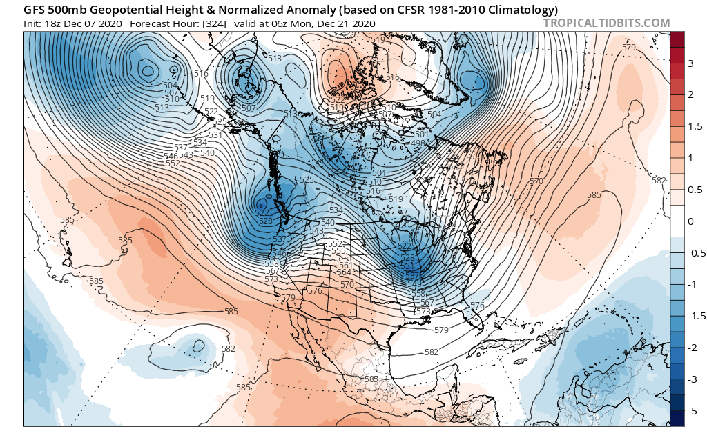
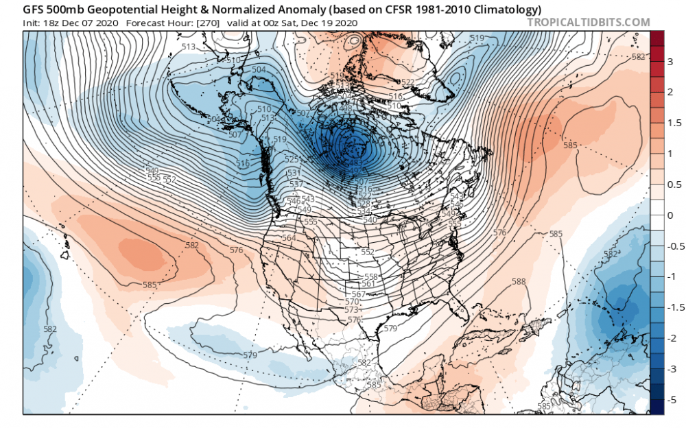
This is the time frame I mentioned couple days ago. It’s interesting to me because of the storm prior to this (15/17th) seems to consistently be there run-to-run. Making for some blocking. However, the ridge out west is all over the place each model run and is super key to this recipe coming together. I think the odds are That the ridge out west flattens out and this cuts. But there’s a chance if we can get inside the weekend and it’s still in some form on the models.
-
Thanks. Either way my moving out of La Niña is the way to go.. but yea, small sample size
-
Nina talk aside.. I like how multiple runs I see the PV building strength then being disrupted. If you look around the 18th, the gfs has strengthen PV and WAR. The WAR isn’t in the most ideal spot but if you pan forward to the 20/21st, the PV sends a lobe of cold air diving SE. We seem to be losing our ridging our west (stupid AK vortex needs take a vacation). I like the look because the WAR does some blocking while cold air builds in central Canada. If we can get a positive/neutral PNA, I think the timing of a cutter could allow for downstream timing to work in our favor... assuming there’s even a s/w there to do anything...
-
Are there any decent analog years for weak Nina flipped to neutral/ weak nino? Like, what’s our goal posts here?
-
Yea, unfortunately that’s not even a great look for LES. Too dry. But at least the Atlantic isn’t awful. I always feel like we have ways to score (usually small) if at least there isn’t a big WAR.
-
That’s the key and how we get lucky now and again. Spacing is close enough where a cutter turns 50/50 and allows the a s/w on it heels to drag the boundary far enough east that it locks some cold on tap. Atlantic will need to ply nice so it still doesn’t run west of us, but not such a pushover that It doesn’t develop and slides OTS. Atlantic can’t be any worst than last year. It was horrendous. I tend to agree with the lag on these big seasonal drivers. But DT is right on the mid Atlantic goal posts — it’s really not till very end of Dec through mid March. WW has pushed itself closer to start of spring over the last 20 years in NOVA and I don’t know how to explain why , but anecdotally, I feel like it has. Totally agree with this If that happens... I see signs of a flexing and waining PNA for us this year, which is a good thing. Do not see that tele as dominant feature either way. As PSU mentioned, Atlantic looks more neutral driver than the killer it’s been (really past two winters). If Nina weakens as we move through Jan then west pac riding becomes more likely and we might score.
-
AK trough rotates down and squashes our +PNA. It’s also a 240+hour frame so I personally wouldn’t bank on this general idea Bermuda high is creepy back in a little more each GFS run. We’d need a stout HL block to prevent cutters each time the PNA relaxes. I actually think the look for D5+ is marginal and trending worse, unfortunately. What would be better is if the one eyed monster would vacate and the Atlantic cooperates. Then we can see sliders, clippers and maybe even an Mill-A
-
Deleted and hiding is semantics. If it’s not up there then it’s being suppressed. Most be nice for you... hide, move posts at your discretion. Manipulate the narrative as you see fit. If you’re not in media you should think about it. You’d fit in perfectly.
-
Lie. it was originally deleted and you just moved here cause I called you out. Thats the truth. Own it
-
I love how posts disappear for calling mods Out for their own banter lol It’s hilarious how sensitive the hall monitors are In here to their own critiques they so willfully hand out to others. Deleted... not even moved to Banter! If something is not offensive or doesn’t use bad language then it should not be completed deleted. That’s un-American in every sense of the idea. The age of censorship... welcome my fellow Americans. eta: oh and @mappy since she is the by far and away the biggest banter accuser and simultaneous banter creator in the whole lot. Its actually impressive the lack of self awareness (incoming response about my lack of self awareness... beat you to it)
-
It’s called humor. Lighten up Uh oh she’s getting mad... Tea kettle starting to whistle Banter We all live in NOVA. Virtually all Bingo
-
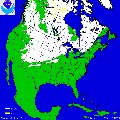
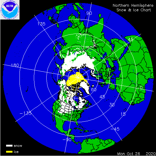
Not a bad looking coverage map for oct 26th Maybe our La Niña winter will buck the trend. October Siberian snow coverage doesn’t look all that robust though. Ehh
-
BWI: 10/27 IAD: 10/27 DCA: 11/14 RIC: 11/13 TB: Warmest October Temperature: 81F
-
Woof. That’s horrendous for mid-late January. One run but yikes. My WAG at the beginning my of the month is slowly turning sour. I really thought the west coast troughing would eventually retrograde as the West PAC ridge pushes into the higher latitudes. Hopefully disrupting that crappy zonal flow we’ve had a bunch. Just hasn’t happened and now with no -NAO help it’s hard to hold any cold air in place... the little bit that’s even around attm. We’ll score.....eventually.
-
Pumping that ridge out west... if this happens and NAO space even gets modest blocking I think we score a fun one (6+) Is that a west-based NAO? It seems a little under the latitude for true -NAO... correct?
-
The issue imo is still the west coast. No ridging per above, and you get this washed out trough on east coast with great low placement. We need that high shown here but with the PNA pumped up a bit. Atlantic has been fairly cooperative. Damn PAC and PNA have not.
-
I like where things are heading. Move gfs through time and the higher latitudes start to look in our favor. Combine that with a PNA that goes positive and a favorable Atlantic, I’ll take our chances late Jan-feb to score 1-2 solid events
-
The problem with “searching” for changes beyond day 10, is that stable features always degrade quicker on models than what happens in reality. There’s a unrealistic expectation that any model can predict even macro level pattern evolutions. Never has been done. So my thoughts are a super strong WPAC ridge has to have an equally strong counter influence at some point to change its reload pattern. Which generally speaking is trough west coast/ridge east coast. That general look will not change until that ridge stops reloading imo
-
Yes, we can hope
-
Not sure I see that signal. -AO perhaps but no mechanism to bring that cold to EC. WPAC ridge remains strong on this