Jump to content

PivotPoint

Members
  • Posts

    714
  • Joined

  • Last visited

Everything posted by PivotPoint
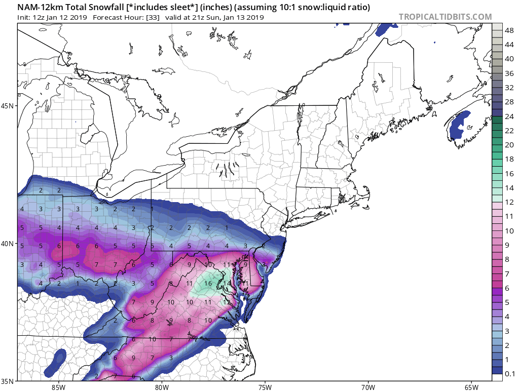
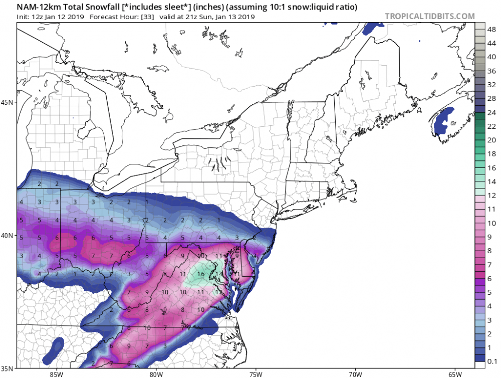
  1. Despair... but my wag for the season is we get some type of transient WC ridge that gives us an overrunning something wound up rain/snow/rain deal. Just don’t think the blocking is there and cold air source keeps getting dumped into western states
  2. Exactly. Well put and exactly what I was getting at irt the timing isn’t quite there for the phase. If that lead wave could make a turn as opposed to progressive (as depicted) it could slow the NS down enough to allow or trough time to dig and phase. Then I think the boundary is ripe for a track that hits the mid Atlantic. All speculation yada yada...
  3. This is not a horrible look and is not wayyy out in fantasy land. It also lines up with period of ridging out west that waxes and wains. The system out in front of this one is a little too progressive. However, if that system cuts just a little bit harder I think we see a run or two coming soon that depicts a coastal in this time frame. All we need is a passing 50/50 or a little help up in the NAO space and a wave in this time period has moderate cold to work with and a potentially better spacing with a little ridge action to help
  4. You weren't the only one quoted in that post, if you recall. Additionally, let it go. Take a chill pill. YOU NEED TO RELAX. Have a sense of humor. I choose my words the way I intend to. No profanity. Read between whatever lines you'd like to. I, on the other hand, will get back to work lol. Oh, mappy. Always so intense
  5. A) No one said that. You've changed the sentence B ) You're one of the worst offenders for "banter" in non-banter threads. Feel free to argue that. I can audit your posts and just repost them here in banter... if you'd like C) Relax
  6. I fwe I feel like this look has loads of potential. Seriously though. Deep trough digging, ridge acres will slide east. High in the NE is probably to Far East at this frame but geez... could happen!!
  7. That's a positive ensemble run. The one constant I take away from this is the look to our NW. Theres enough cold for snow and 60-70% of members give western Maryland/pa some snow. Which to me means that there something can break a little more in our favor (inside 3-4 days). Just a WAG Same thoughts. Like the look to our NW. Way better than a shut out, raging SE ridge look Ninja'd. I noticed the same. The trough is sharper but our wave is not tucked. Little too late. It will be cool if something popped inside 3 days Haha, that's too funny
  8. Ridge axis is too Far East doesn’t allow our trough to tilt the way we need it to. But yea man, realllll close Anything at this point would be ok. Even a sloppy two inches. It’s the times we live in ugh lol Not too worried about ensembles. There’s so many different scenarios in the game attm. You obviously know this better than most.. for general information though.. it’s possible and that’s all we can ask for
  9. +1 to this. Point I made earlier - if we can get PNA ridging with the right axis on the ridge (Idaho) then we can score. I’m confident we align a wave and have some of a cold source to tap, if we can get the PNA to go positive and oscillate in positive territory for a 10-14 day period. I think it’s a 20-30% chance it does that this winter. But still a possibility imo
  10. You’re right. I probably am too concentrated on the details. I will say it’s interesting to see at least some progressive ridging developing across the west coast. Still fighting circle of doom in Alaska. We need more stable ridge in the west coast to develop since we’re getting close to February and wave lengths will begin to change in a few short weeks.
  11. You make good points but you’re using bias confirmation (known gfs bias) to explain the more amped solution of the gfs vs cmc. In reality, it could be an over amplification or it could be picking up the time period dynamics more accurately. Time will tell. But I disagree that there is amazing agreement in the sense that, yes, the anomalies are similar in their relative positions but the strengths are fairly different (euro and cmc) vs gfs. You’ll probably end up being correct that the gfs has over amplified the shortwave, but we do not know that, and I would not automatically attribute it to a “known bias”. I think that is a bit premature to say, imo.
  12. I knew someone would chime in! It is different... And I’m not just talking about the surface. if you look at side by side comparison of 500mb heights for same time period GFS clearly builds stronger positive anomalies through Hudson’s Bay which provides much stronger blocking for our trough to turn negative. Id agree they’re not worlds a part in terms of 60s and sunny vs. 30s and rain, but they are still very different and shows a larger spread. I know 240hrs seems like an eternity but in age of 2020 and super computers I still find it amusing that the differences can be as large as they are... even for 240hrs.
  13. Geeze... that’s so awful for our best climo period. Hopefully mid February shows signs of life
  14. Which one is the chill storm by the way... 1/25, 1/30, or 2/1?
  15. Lol at how different the cmc is to the gfs same time period. cmc Gfs
  16. Very good explanation. And describes the reasoning behind why getting anything significant here for the next 10 days or more would be a big challenge. Let’s hope the AK vortex shuts down and ridging returns to west coast. We need the AO to be negative at some point if we’re going to score later in the season. Cold air has to rebuild back in central Canada.
  17. There are a few returns around Leesburg heading W NW. they might allow for a few more flurries for western counties
  18. Woof. That’s horrendous for mid-late January. One run but yikes. My WAG at the beginning my of the month is slowly turning sour. I really thought the west coast troughing would eventually retrograde as the West PAC ridge pushes into the higher latitudes. Hopefully disrupting that crappy zonal flow we’ve had a bunch. Just hasn’t happened and now with no -NAO help it’s hard to hold any cold air in place... the little bit that’s even around attm. We’ll score.....eventually.
  19. Pumping that ridge out west... if this happens and NAO space even gets modest blocking I think we score a fun one (6+) Is that a west-based NAO? It seems a little under the latitude for true -NAO... correct?
  20. The issue imo is still the west coast. No ridging per above, and you get this washed out trough on east coast with great low placement. We need that high shown here but with the PNA pumped up a bit. Atlantic has been fairly cooperative. Damn PAC and PNA have not.
  21. Not gonna happen. SE ridge pumping up out in front of the primary tracking north of us. 6z gfs says it’s all but over. Think this one is toast
  22. Strengthening Atlantic ridge + sharper trough = not gonna happen on this one. On a brighter note, we have a pattern change upon us once this crappy system clears through. Ridge building out west and shortwaves diving through the southern states for at least next 5-7 days after this weekend. I’ve thought for last two weeks that come end of January and beginning February we start to see real chances. I think it’s coming down the pipeline.
  23. Gfs bending the knee to euro. To be expected. Initial thump is muted from 6z. Still 1-2”... maybe
  24. Seems like trough axis in euro is slightly sharper and titled negative. Gfs flatter. Given the delay in onset talked about in the noaa discussion I’d lean more towards euro. Gfs seems to quick with flow and onset of heavier WAA
×
×
  • Create New...