PivotPoint
-
Posts
714 -
Joined
-
Last visited
Content Type
Profiles
Blogs
Forums
American Weather
Media Demo
Store
Gallery
Everything posted by PivotPoint
-
I like where things are heading. Move gfs through time and the higher latitudes start to look in our favor. Combine that with a PNA that goes positive and a favorable Atlantic, I’ll take our chances late Jan-feb to score 1-2 solid events
-
I love that you live up there too. Stay there forever! Crushing now in McLean

-
Nice! 42 here in A-Town ballston
-
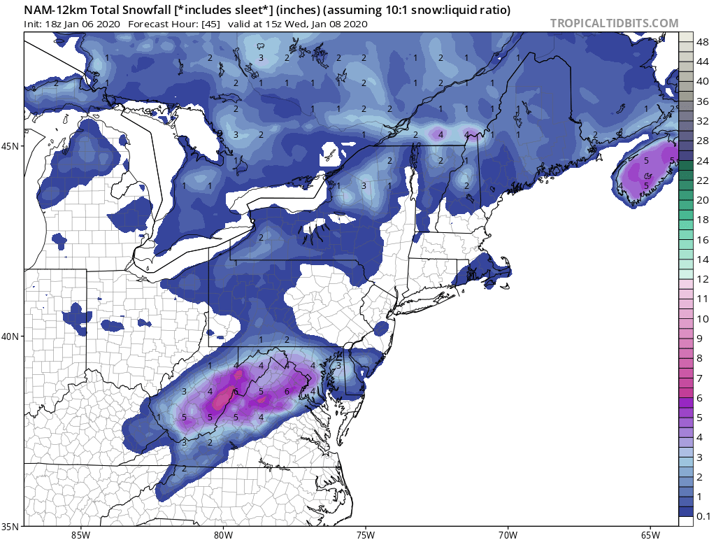
I was pretty confident that the cities would inevitably get screwed. Gfs has been pretty steady overall with not giving outrageous total from such a fast moving system. Now the low level warming trend as event approaches has started. DC is in for less than an inch but points NW will still see a little more.
-
Gfs looks meh. Has rgem bubble forming around dc. Warmer too by a smidge
-
My gut says dc gets good snow tv but blanked on tha accum department. McLean on NW and Rockville points west see 1-2. Hagerstown cashes in. Winchester down to snowshoe and valley gets the goods on this setup. Eitherway nice to be in the game. I’ve seen signs of PNA perhaps flipping and PAC jet finally slowing down a bit
-
Snowshoe is gonna get lit up. Nice
-
If we get 1-2” I’ll be estatic. Plus I work in Rockville and we all know the ROCKVILLE death band is real
-
Snowshoe is gonna get lit up. Nice
-
Nam for the win!! lol

-
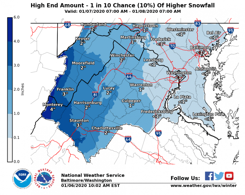
I love how NOAA 10% chance is still <1". What a joke. I think given the current guidance since last night... it's pretty clear that over an inch (even slightly) is a 1 in 10 chance possibility, imo
-
Discussion thread... keep it clean!
-
This has the potential to rip a couple hours on the front end. It’ll be too warm for real accumulation but the omega for snow growth looks nice. Perhaps an inch to score a coup during the dark days
-
The problem with “searching” for changes beyond day 10, is that stable features always degrade quicker on models than what happens in reality. There’s a unrealistic expectation that any model can predict even macro level pattern evolutions. Never has been done. So my thoughts are a super strong WPAC ridge has to have an equally strong counter influence at some point to change its reload pattern. Which generally speaking is trough west coast/ridge east coast. That general look will not change until that ridge stops reloading imo
-
Yes, we can hope
-
Not sure I see that signal. -AO perhaps but no mechanism to bring that cold to EC. WPAC ridge remains strong on this
-
Trough in the west shows persistencey across most guidance. I saw this west coast trough and western pacific ridge early on in October and later in November. Thought to myself “that’s not a good direction”. Funny how these features can be hard to get rid of. Just like NAO blocking. Big pieces don’t always move so easily. Definitely thinking below avg snow fall this winter with avg to moderately above avg temps. Hoping we can pull off a couple -AO periods with PAC Jet settling down long enough to allow decent spacing for something to pop late January. Happy New Year
-
Any update on Stowe or Jay by chance would be greatly appreciated. Have they been mostly snow or are the getting the mix bag? Was thinking of making the hike up from VA but wanted to check with the local knowledge first. Thinking the upslope looks palatable perhaps through Thursday. Thanks guys... congrats on the snow (or frozen, at least)
-
Medium heavies lined up to my NW here in Clarendon. Might get another .5” lol By the NAM called this. Don’t care anyone says Banding, qpf, etc. was jumpy but it saw the potential first and I watched every single model run
-
Just over 11” on my parking roof in Arlington (Clarendon) What an incredible storm. Over 31 hours of continuous snowfall with a few very brief lulls oh, and it’s snowing again lol. Legit rates as the snow to the NW pivots through. What a day
-
Heaviest rates yet here in Arlington. ULL love. You can see the small wave like bands pushing from the southeast
-
This band means business. Roads caving again
-
Band about to pivot through Arlington/dc Hopefully this one means a little business
-
That is a good beer for deform action. Denseeee
-
These bands are kind of breaking up before they hit Arlington. We’ve kinda in this pseudo snow hole all day where nothing hard charges through with out deintensifying a bit. Hopefully that trend changes