

CAPE
-
Posts
36,292 -
Joined
-
Last visited
Content Type
Profiles
Blogs
Forums
American Weather
Media Demo
Store
Gallery
Everything posted by CAPE
-
The bay definitely impacts climo locally. I especially notice it in Fall and early winter driving from my house in the interior to Easton and points west. Always several degrees warmer there, and later frost/freeze.
-
Some abnormally dry in eastern DE, with a small area of moderate drought at the immediate coast around Rehoboth.
-
Pretty big differences between the GFS and EURO wrt the evolution of the upper low and eventual coastal surface low track. Trend is somewhat drier overall, but best chances for significant rain in our region appear to be further inland and more towards the SW portion, with the coastal low further offshore. Folks in NE in the drought stricken areas will love the GFS, while the EURO says enjoy the nice dry weather.
-
57 here. Heading outside to do yardwork shortly.
-
For those who have La Nina winter doom, the forecast is still for the Nina to generally weaken through winter. Equal chances of Nina or Neutral by the latter half. From the CPC ENSO discussion updated yesterday:
-
The weekend looks glorious. Perfect for reseeding.
-
I was just looking at that. Thinking the same thing. Could be good for here early Jan.
-
Major pattern change in progress. Looks like highs mostly in the upper 70s-low 80s over the weekend and next week. Probably some shower chances too. Bring it.
-
Barely a quarter inch here.
-
Outside of a Modoki Nino with persistent HL blocking, getting snow is a crapshoot, and we mostly score with fluky/well timed events east of the highlands. The big EPO ridge winter of 2013-14 was fluky, despite having some significant cold around. Could have easily been a lot of cold and dry, mild and wet with a general lack of NA blocking. The coastal plain doing well last Jan when the pattern shifted to colder (while inland NW areas mostly missed out) was pretty fluky. Multiple scrapers that could have easily been fish storms and complete misses everywhere. We just can't know, esp not now lol.
-
There will be a threat for warning criteria snowfall, and you will track it.
-
What do you think lol? It's August and we want a tool that gives us an idea of what the general pattern will be in January. Outside of Enso, there isn't much else that's worth a damn at this juncture.
-
CFS is on one of its good runs lately. There's hope!!
-
87/73 here currently. High was 90.
-
A local AFD will feature the phrase "uncomfortably dry".
-
I got weenied a few weeks back by a couple posters in the July LR thread for suggesting that late July/early August would likely feature typical peak summer weather, and nothing extreme. Warminstas be serious about the big heat tho, even when it only 'exists' on a GFS op run 300 hours out.
-
87/72 Sultry.
-
Yeah pretty typical heat the last few weeks. More humid than hot. I think I hit 94 one day here, but other than that its been mostly mid to upper 80s and a few low 90s. The high dews make it gross if you have to be outside physically doing something.
-
Perhaps an extended period of normal/below normal temps, and some days with reasonable dew points for mid month period.
-
This looks refreshing.
-
Need a little phase shift.
-
A couple downpours today added up to 0.35" Up to 3.1" since last evening.
-
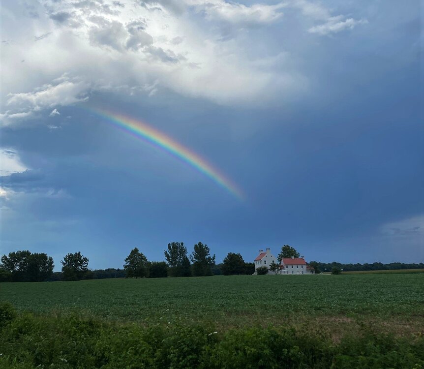
A shot I took about a half mile from my house driving home from Centreville. Ended up with a quarter inch from this pulser that mostly missed to my SW.
- 899 replies
-
- 11
-

-
Lost an oak tree last night. Snapped off a couple feet from the ground. The wind was probably 40 mph at most, so it had some issue. I already have 2 stacks of wood that are seasoned and need to be split. Plenty of firewood for the next couple years.
-
Had another round behind the main event. Total of 2.76". After getting next to nothing over a 2+ week span with multiple high probability chances for significant rain, this happens on a day where the forecast called for a 30% chance of a tenth or less lol.


