
CAPE
-
Posts
34,276 -
Joined
-
Last visited
Content Type
Profiles
Blogs
Forums
American Weather
Media Demo
Store
Gallery
Posts posted by CAPE
-
-
Faint signal on the GEFS for the 28th. A long way off, but the 26th seems to be the beginning of the window of interest based on current guidance. Much of the heavier precip is along the SE coast and offshore on the mean from the 26th- 29th.

-
 2
2
-
-
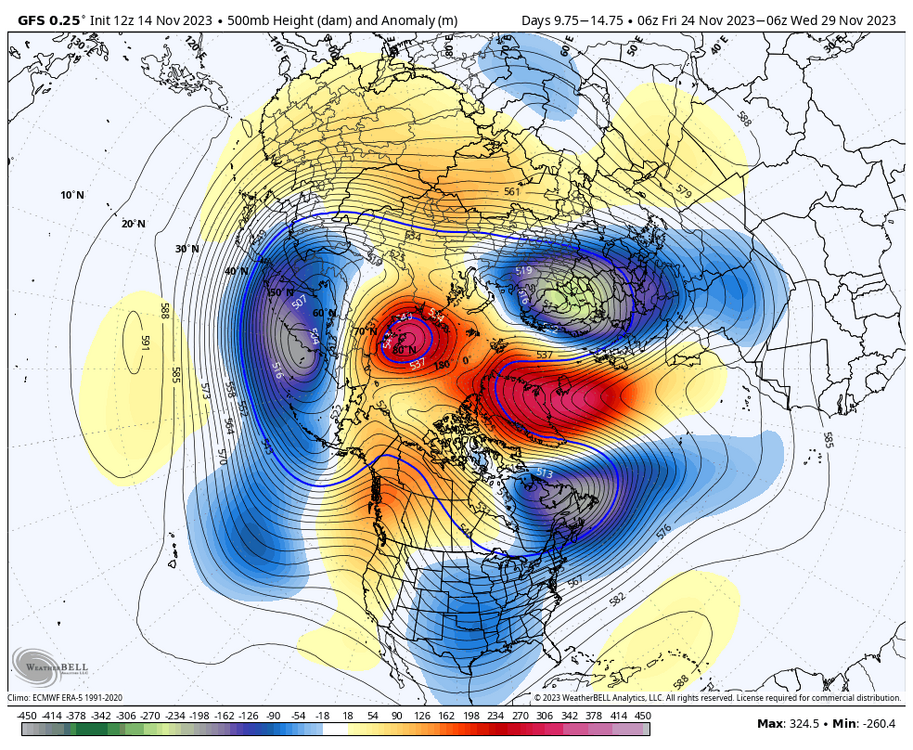
Canadian has the ridge bridge. Impressive -NAO.

-
10
-
 1
1
-
-
4 minutes ago, nw baltimore wx said:
12z gfs wakes up the nino water hose.
That would be a wet Thanksgiving eve.
-
1
-
-
3 minutes ago, Ji said:
2 of the last 3 moderate Ninos had a cold/snowy December lol
We rarely see wall to wall cold in Dec in these parts regardless of Enso state.
-
25 minutes ago, WxUSAF said:
MJO progression into phases 3-4 (if it gets there) would suggest warmer risks going into December. That would also fit mod+ Nino climo. So we’ll see. But I think we get some sort of event in December.
Yeah latest GEFS has it progressing through phase 2 at low amplitude, then into phase 3 but pretty weak. Other guidance has it weaker and then into the COD before progressing into phase 3. We shall see. Probably will have a mild period in December regardless, and the state of the SPV going forward is a wildcard.
-
1
-
-
The latest extended products depict the continuation of a respectable to favorable longwave pattern into Dec. Both the Euro weeklies and GEFS ext maintain the same general h5 look, with normal to below normal temps for eastern US the entire month verbatim. Certainly no suggestion of a hostile pattern or a 2 week+ torch. Mid to late month actually looks the best on both, a pretty classic Nino look with lower heights across the south/southeast US (fwiw).
-
13
-
-
37 minutes ago, WxUSAF said:
6z gfs agrees
Sure does. And the pattern reloading at the end of the run. The SPV becomes quite perturbed on the GFS beginning next week, so this is likely influencing what is being depicted at h5.
-
9
-
-
6 hours ago, TSSN+ said:
Great Lakes lows always putting a damper on things lol
That's not some random, poorly timed GL low messing up our mid levels. That is a piece of TPV energy dropping southward as it gets pinched off with the amplifying ridge out west. The pattern is just evolving at this point. That TPV lobe(or multiple pieces) phasing with/deepening the existing trough near the Canadian maritimes is what sets up any potential NA blocking heading into the last week of the month. Imo that period probably offers the better potential for snow chances east of the mountains as the pattern will be more established with a colder air mass more entrenched.
-
16
-
-
Op run I know but this is only a week or so out. Look at the amplitude of that EPO ridge. All sorts of wave interaction/wave breaking going on. Another TPV vorticity lobe gets pinched off the under the anticyclonic wave break and drops south.

-
4
-
-
A red pepper bridge with avocado underneath. Looks like a cold Thanksgiving.

-
13
-
 1
1
-
3
-
-
Verbatim places NW of the Fall line see a little snow. A coating to as much as 2" in the northern hills of Carroll County.
-
Winter may be saved!
-
1
-
8
-
-
Mount PSU special on the 18z GFS for next week. A couple inches.
-
8
-
-
6 minutes ago, poolz1 said:
It is interesting that it seems like the op runs have been leading the way with the advertised HLB especially in the NAO domain. Getting there with each run but all 3 global ops have had some impressive blocking the past few days.
It has mostly been popping on the GFS, and the GEFS has been more emphatic the last couple runs. EPS has been hinting though.
-
8 minutes ago, brooklynwx99 said:
i want to see if we can get that wave breaking -NAO to keep showing up, similar to what the OP GFS has been doing. those blocks are flukier than traditional retrograding Scandinavian blocks, but they work all the same
i mean, talk about loaded. this is a December airmass with blocking. just want to see that -NAO show up more on ensembles
Yeah as of now its mostly been the GEFS on the ens guidance, outside of something very transient. That's a pretty nice dipole right there. The deep vortex retrogrades westward before weakening, and the next one is moving N to reinforce the +heights over GL. Like you said, it wouldn't likely be a sustained blocking pattern, but still can work with a bit of timing.
-
1 minute ago, Eskimo Joe said:
If we can get some snow along the Blue Ridge it should help mitigate the wildfire risk. There are still a half dozen active fires.
That area and esp further west would be favored for frozen with the depicted pattern and being so early in the season. Fighting climo in the lowlands.
-
7 minutes ago, SnowenOutThere said:
You can tell even from the op runs that it *looks* different than the crappy Nina base state we’ve been in for years with there being actual cold behind storms instead of endless warm cutters.
Storms can still cut, esp early in the season. I get your point though. Big difference with the features in the NPAC.
-
2
-
-
GFS delivers back to back snow events for places just to our N/NW. Crazy op run 300+ hours out. Have to continue to watch this period on the ens guidance.
-
4
-
-
1 minute ago, Eskimo Joe said:
Looks like the medium to long term guidance is starting to pick up on the consequences of the EAMT event that @brooklynwx99talked about.
They have been 'seeing' that for multiple runs now. The looks in the NA on some recent runs are interesting.
-
12 minutes ago, WxUSAF said:
12z GGEM is crazy cold for thanksgiving and would suggest snow flurries/showers verbatim especially for folks N/W and in the mountains.
Pretty wild look on the 12z GFS. This becoming our first legit 'period of interest'?

-
13
-
-
Heavy leaf drop warning in effect. Just pouring leaves now with this wind.
-
2
-
2
-
-
1 hour ago, Ji said:
We need to induce an early snowfall to avoid a psu meltdown
Sent from my SM-A515U using Tapatalk
Here we go
")


-
6
-
1
-
-
4 minutes ago, psuhoffman said:
the book hasn’t been wrong yet…
It was interesting that you brought it up in sort of a negative context, given the ens guidance has been depicting a pretty favorable h5 pattern towards the end of the month, and there have been plenty of good vibe posts made wrt that over the past few days.
-
7
-
 1
1
-
-
30 minutes ago, Ji said:
We need to induce an early snowfall to avoid a psu meltdown
Sent from my SM-A515U using Tapatalk
..and save winter for the greater DC area
-
4
-

November Mid/Long Range Discussion
in Mid Atlantic
Posted
Spire lookin good")