

CAPE
-
Posts
34,276 -
Joined
-
Last visited
Content Type
Profiles
Blogs
Forums
American Weather
Media Demo
Store
Gallery
Posts posted by CAPE
-
-
1 minute ago, Daniel Boone said:
Hopefully, that goa low will be further west.
It is on the ens mean.
-
 1
1
-
 1
1
-
-
6 minutes ago, CAPE said:
Pretty good post from you. More please.
The oddity is the trajectory of the low track . It's essentially an Albert Clipper. Not so common in early Dec. EJ is correct though. 50-50 low. HP to the west over the GLs- results in a nice feed of cold from the north into the storm. -NAO forces the low to track to our south.

-
7
-
-
12 minutes ago, Eskimo Joe said:
While I understand this is a single run of an operational model, the 18z GFS has a nice banana high on the Dec 5 - 8 event. That is a requirement for early season snow of any consequence, and difficult to get without Atlantic blocking. Good to see. More please.
Pretty good post from you. More please.
-
6
-
 1
1
-
-
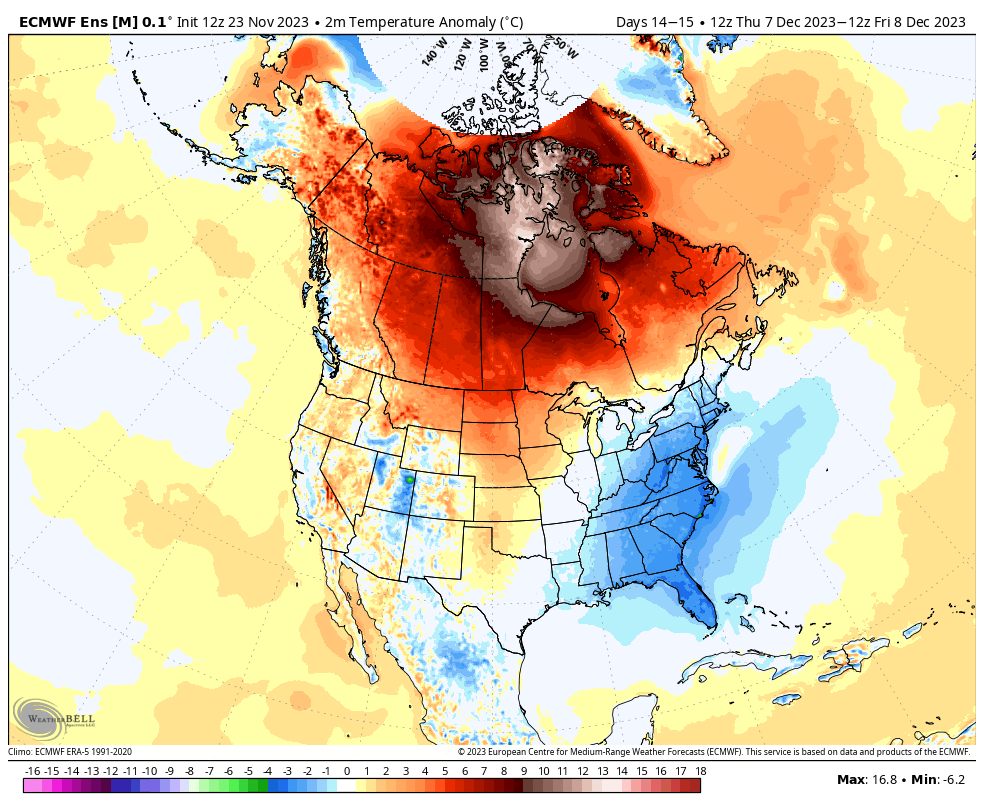
Just for fun, the Black Friday edition of the Euro Weeklies for late Dec, centered on Xmas.

-
11
-
1
-
 2
2
-
-
19 minutes ago, Shaulov4 said:
You initially have a rainmaker (maybe some snow for the deep interior( around the 4th and a piece gets left out south. Development emerges in the gulf and leads straight to the boundary that the first storm lays out. An initially stronger system can lead to a cold secondary storm and the fresh cold injection gets pulled in. If not, we can still get a dynamic cooling event depending on low placement and strength. I do believe it will be a two storm setup as the first one ushers in a colder and perhaps snowier pattern. Don’t throw rocks if I’m wrong however.
No rock throwing lol. Sounds impressive. Probably a bit too much detail on the analysis for 10 days out though.
")
-
1
-
-
This has been a pretty persistent theme on the ens guidance for around the 5th- an OV low/coastal transfer. EPS suggests some snow for us this run.


-
10
-
2
-
-
2 minutes ago, Ralph Wiggum said:
And we've also had our fair share of epic Atlantic looks and even EPO help in recent years with zilch to show for it due mostly to a muted or raging -PNA. A huge part of our run of poor luck is the lack of a good PNA in the the PAC. So far this early in the season we are seeing signals of a decent PAC side which we definitely could use. So the LR outlooks have that going on which could be the game changer this winter.
The exact position/strength of the NE Pac(Aleutian) low is equally important to the NA state(arguably more so), compared to a just a couple decades ago. Encouraging to see the guidance retrograding it further west and popping a PNA ridge in the long range. Last thing we want is that feature parking in the GoA or worse.
-
6
-
-
Sea effect snow season has begun in NW Japan. Watch it pile up over the next 3 months.
-
6
-
-
This would be a good sign heading into early winter.


-
9
-
-
13 minutes ago, WxUSAF said:
I’ve got reds in all the right places!
If the trends continue we might see legit below avg temps by Dec 10th.
-
5
-
-
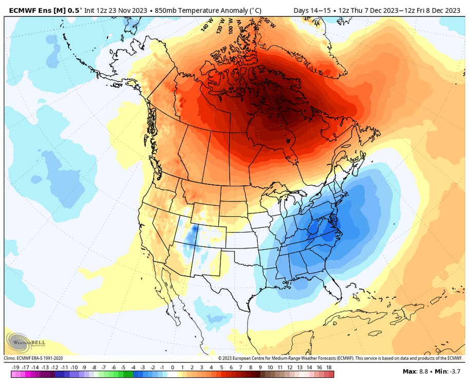
All 3 ensemble means have the PNA trending positive by December 7th now.
-
5
-
1
-
-
The general idea on the latest ensemble runs is the primary storm track remains to our northwest through about December 3. Beyond that there are indications of low pressure development along/off the MA coast. We shouldn't expect to see guidance lock in on anything specific at this range, but over multiple runs there are hints from Dec 4 onward. With an active southern jet there should be chances. The advertised pattern looks seasonably chilly for the east, but not especially cold.

-
7
-
2
-
-
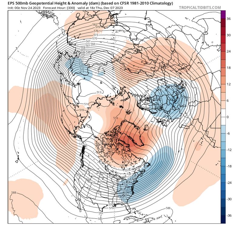
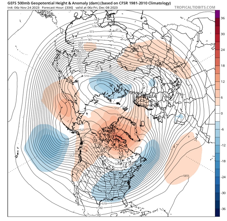
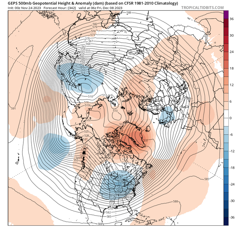
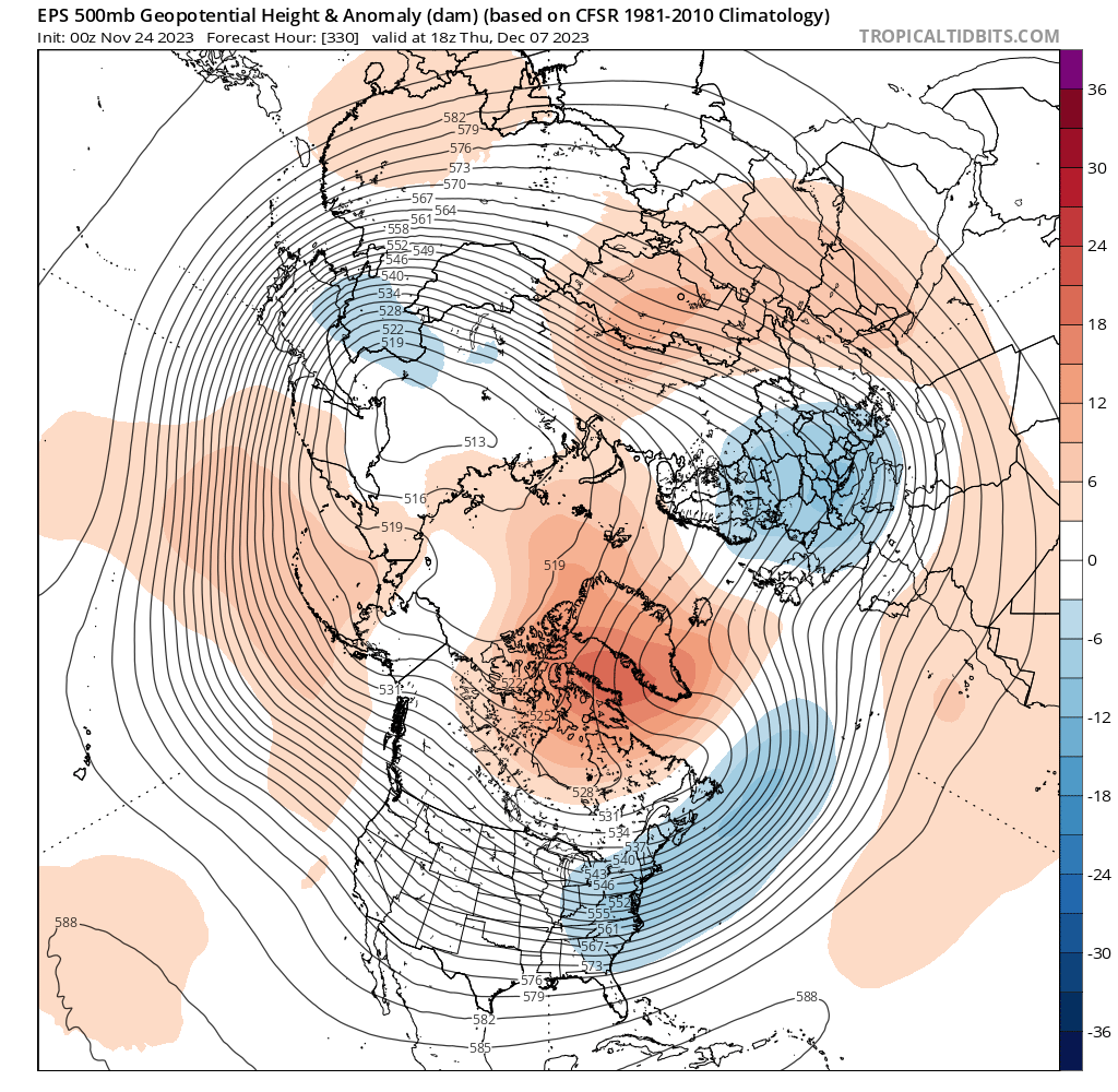
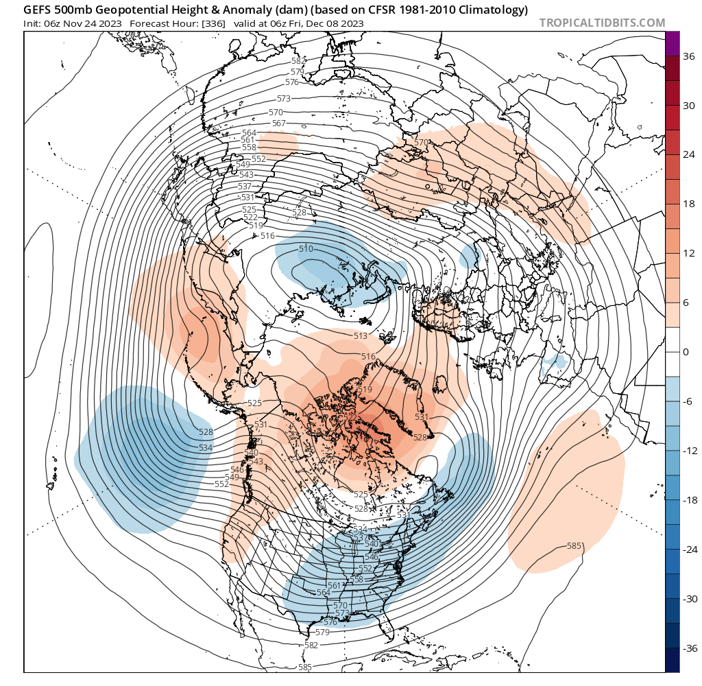
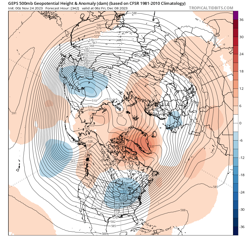
These 3 panels should give everyone here a good feeling with winter a week away.


-
17
-
3
-
-
EPS > GEFS


-
3
-
1
-
-
Just now, AtlanticWx said:

where?
EPS is colder than the GEFS for that period.
-
3
-
-
GEFS likes the 5th for a storm. As is typical, the mean follows the op with an OV low and coastal transfer. Verbatim it's a bit warm. The 6z run had a similar evolution for that timeframe. The GoA low would be the primary issue for this period. Subject to change though this far out.


-
3
-
1
-
-
Improvement on the GEFS over the last few model cycles. The 0z run has +h5 heights centered over Baffin, and the Pacific look is somewhat better. The exact MJO progression is likely the biggest driver of the Pacific pattern for the early/mid Dec period. The latest runs are generally weaker in phase 3, and take it into the COD before/just as it gets into phase 4.

-
12
-
-
^The EPS continues to indicate a much improved look in the NAO domain over the last few runs for that period. It has gone from a flat central Canada ridge- more of a Pacific puke mild look- to a pretty impressive -NAO for the first week of Dec. Still not a very a cold look with that GoA trough. My guess is the less favorable Pac will be temporary. GEPS has a ridge popping over AK towards the end of its run.
-
7
-
4
-
-
4 minutes ago, AtlanticWx said:
that's a GOA low, which is a classic feature of Ninos. look at the height lines which point upwards over Idaho, that's a decent signal for a ridge in the west this far out with all the smoothed means. i think you need to let go of whatever nina base state panics ur having bc now we're in a solid nino
He is focusing too much on the anomalies(pretty colors) instead of the height lines. On LR tools it's the 'general idea'. Some get it, some don't.
-
4
-
-
Just now, Eskimo Joe said:
I love your enthusiasm and willingness to provide deep insight. Don't let my eternal pessimism get you down.
lmao no chance. you do you dude. we all contribute in our own way.
-
1
-
1
-
-
-
9 minutes ago, Eskimo Joe said:
The 12z Canadian ensemble would be my preferred evolution. Good Atlantic and Pacific with split flow. The Euro would be an unmitigated disaster and set us up for failure.
Here is the pattern progression on the Euro extended based off the 0z run, into mid Dec. Heading towards an unmitigated disaster and ultimate failure?

-
8
-
-
4 minutes ago, Eskimo Joe said:
The 12z Canadian ensemble would be my preferred evolution. Good Atlantic and Pacific with split flow. The Euro would be a disaster and set us up for failure.
It's a long range snapshot on a smoothed ens mean. Chill lol.
-
1
-
4
-
-
There is some improvement on the 12z EPS compared to 0z in Canada/NAO domain (and to a lesser degree the NPac) for the end of the first week of met winter. We shall see which way the pattern goes beyond Dec 3- some of that answer depends on the MJO progression. It could just be a brief reshuffle and a short lived milder period before a mid month reload. Just a few more model cycles..


-
4
-


November Mid/Long Range Discussion
in Mid Atlantic
Posted
Ok now you are kind of ruining it.