
CAPE
-
Posts
34,276 -
Joined
-
Last visited
Content Type
Profiles
Blogs
Forums
American Weather
Media Demo
Store
Gallery
Posts posted by CAPE
-
-
12 minutes ago, Ji said:
I read the thread. The 12z eps dosent always agree with the 00z so I was happy to see a continuation of the idea. As you said…nothing much to be said so I said nothing muchBut you got EJ all excited with the "really interesting!!!'. He thought it suggested an early season blizzard or vodka cold or something.
-
 1
1
-
-
1 hour ago, Ji said:
Eps Looked really interesting post thanksgiving!
Maybe read the thread a little before making cryptic hyperbolic posts about things that have been rationally discussed several hours earlier lol.
-
 2
2
-
-
The EPS h5 look for that period was discussed this morning. The latest run looks much like 0z, which trended better from 12z yesterday. Not much else to say, other than lets hope we see a similar look when it can actually snow east of Canaan.
-
4
-
-
24 minutes ago, PrinceFrederickWx said:
I got a whopping total of 0.07” for that system, which is also my monthly total. This is looking like a lock now for driest year since I moved to Prince Frederick a decade ago. Not a good sign for winter IMHO
A tenth here. Its pretty darn dry. We should see the Nino STJ start to juice things up in the next few weeks.
-
1
-
-
High of 55 here. Currently 50. temps should drop quickly this evening with barely a breeze and a mostly clear sky. Could be a bit more in the way of clouds later. Might get near freezing here, but I doubt lower than that. Tomorrow night should be colder.
-
-
12 minutes ago, Weather Will said:
Dreaming of a White Thanksgiving? WB 6Z GFS
There is a tiny, sporadic signal on the means suggesting some flakes could fly during that period. Good bet for the western ridge with cold upslope flow in the wake of an early week storm. EPS is less bullish on a cold Turkey day.
-
2
-
 1
1
-
-
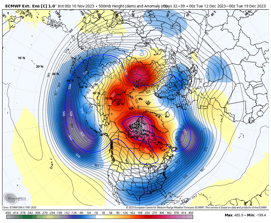
Over multiple runs on the 3 ensemble means, it appears the N Pacific is reshuffling into a -EPO/neutral-ish PNA look. I wouldn't mind if that pattern locks in. On the Atlantic side, it looks like any ridging in the NAO domain will be transient in nature heading into December. Something to keep any eye on, but for now the AO/NAO looks to remain close to neutral.
-
10
-
-
EPS has been trending towards a nice high latitude look in the LR over the past few runs.

-
10
-
1
-
-
2 minutes ago, Jersey Andrew said:
Does this have any similarities to December 2009 or am I just hallucinating?
Check out my profile pic. Pretty close.
-
4
-
-
1 hour ago, brooklynwx99 said:
holy shit lmao
Admittedly pretty fun to look at at HH, with a bit of weed.
")
Totally weenie tho.
-
4
-
7
-
-
30 minutes ago, WxUSAF said:
The “For You” tab for my Xwitter is this hilarious mix of random weather accounts that seem evenly divided by:
”Super Nino east coast winter torch inbound!”
”This Nino is different, looking cold and snowy for the east coast this winter!”
Here is one on mine. Funny read. Replies include one from DT lol. These dudes throw around terms/acronyms like 'downwelling kelvin waves' and WWB left and right, but its unclear if they truly understand the complexities/ ramifications of any of it. My guess is mostly no. Hyperbolic for the clicks is the game. Comical.
-
The advertised pattern for the end of the month into the beginning of Dec is one we would love to see more of going forward. Verbatim there will probably be some snow for the western highlands, and not out of the question that places just west of the Fall line see a bit of snow during this period. Looks seasonably chilly at the very least.


-
12
-
2
-
-
5 minutes ago, mattie g said:
I need to stock up on BCBS this year. Beer geeks sh*t on them because the "sold out" to Goose Island, but it's simply one of the best and most reliable BA stouts around.
My best friend has a huge stash of BA beers (including BCBS) that he needs to offload due to not being able to drink much anymore. He reached out and asked if I want a bunch of them...definitely need to take him up on the offer.
It's solid. Always easy to find too.
-
1 minute ago, aldie 22 said:
funny because Webb just canceled December on X
Well there is some disagreement on the pattern progression. EPS keeps us on the mild side, while the GEPS is more like the GEFS but not as cold for the east. That said, we always know what he is gonna push.
-
1
-
-
1 minute ago, Chris78 said:
Not sure why some (not you) are freaking out over not having a great pattern in the first half of November.
If we were abnormally cold in November it would still mean rain except for the west highlands.
And if November was cold December would probably snap back and be way above normal.
Seeing that TPV fall apart is a good sign. The last thing we want at this juncture is a strong, consolidated SPV, especially with a reflection at h5 in that location.


-
1
-
-
Remains to be seen how exactly the pattern evolves beyond mid month. As the strong TPV north of AK breaks down, the latest GEFS run digs a trough further east over the Aleutians, with a downstream EPO ridge developing in a better spot. That places a trough in the central US that would progress eastward bringing a cold airmass for the end of the month.


-
12
-
-
8 minutes ago, psuhoffman said:
It’s impotent because there is a huge SER that’s winning the airmass war. I see that as an unrelated problem. I’m not sure there is anything about the blocking that’s part of that. Same as the last few. We had a near record block last year and we torched because of the SER.
Upstream is clearly important regardless of the strength/persistence of any NA blocking. More so these days. We torched last year during that blocking episode because of a SER induced by a deep US western trough, itself induced by an impressive Aleutian ridge, courtesy of La Nina.
-
2
-
-
This would be a pretty good look at range (a month later) if it persisted over multiple ens runs.

-
6
-
-
1 minute ago, psuhoffman said:
On the 18zgfs the NAO goes neg around Nov 17 and stays strongly neg through the end of the run on the 25. Imo that’s legit. It’s failure to assist our snow chances on that run was a product of the mid latitude pattern and the pacific not anything to do with the NAO in my opinion. But we might be arguing apples and oranges here.
Probably. While the upper ridge in the NAO space is there on that run, it's impotent as advertised, and it will probably be completely gone at 0z. Let me see it persist over multiple runs and on the means. Sometimes we see heights rise in the NAO domain briefly, but need perfect timing with a wave. What I like to see- and is most useful esp in a Nino- is a sustained blocking pattern(dipole) where we just wait for a legit wave to track underneath. Also snow chances suck regardless because it is November.
-
14 minutes ago, psuhoffman said:
While I’m not 100% sure how you mean “bootleg” but I’d refrain from that language because to me it implies the NAO isn’t legit or is in some way not canonical. But the -NAO on the 18z Gfs is a canonical -NAO coupled with a 50/50 vortex and even western Canada/EPO ridge! The fact that it doesn’t impact the eastern CONUS mid lat pattern and links with a huge SER again isn’t due to any deficiency in the high latitude pattern.
Just like what’s happened several times in the last 7 years, the SER simply wins. The western energy cuts under the high latitude flow out west then fails to progress and flatten the SER. Instead the SER pumps so much in response to that approaching wave it becomes a mid lat block and stalls the progression. We’ve seen this exact thing play out a lot and it’s why we’ve been in such a funk since the only way historically to really overcome a crappy pac cycle was with a -NAO. But recently it hadn’t worked.
But it’s hit because all those NAOs were “bootleg” they simply aren’t having the same impact on the mid latitudes because the SER is winning the see saw tug of war battle in the flow.
To me, it means not useful/ not a sustained atmospheric blocking pattern. A transient -NAO is a crapshoot at best for our purposes. An actual(and more useful) sustained negative NAO is difficult to identify from a random op run or 2. A true NA blocking pattern is usually something that becomes evident over multiple ens runs.
-
2
-
2
-
-
1 minute ago, Ji said:
he gets work when it snows in the DC area. He has been" unemployed"now for years. he will be back this winter
Thought he was more semi-retired. He is a legend in local forecasting. There surely is work for him if/when he wants it. His contributions are always value adding.
-
5
-
-
3 minutes ago, Stormchaserchuck1 said:
18z GFS is now developing a -NAO in the MR/LR where it used to have +NAO
It's bootleg and couples with an amplifying anomalous eastern US upper ridge, as a deep trough digs out west. Same thing we saw multiple times last winter. Just another random GFS op run though.
-
1
-
-
Sipping on a 2022 BCBS for HH. So nice.
-
2
-
November Mid/Long Range Discussion
in Mid Atlantic
Posted
GEFS extended-