

CAPE
-
Posts
36,846 -
Joined
-
Last visited
Content Type
Profiles
Blogs
Forums
American Weather
Media Demo
Store
Gallery
Everything posted by CAPE
-

January Medium/Long Range: Chasing more snow to close out the month
CAPE replied to mappy's topic in Mid Atlantic
-
One more
-
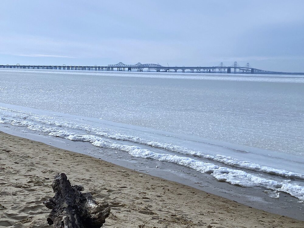
Photos from Terrapin today
-
January Medium/Long Range: Chasing more snow to close out the month
CAPE replied to mappy's topic in Mid Atlantic
As the model guidance turns.. -
January Medium/Long Range: Chasing more snow to close out the month
CAPE replied to mappy's topic in Mid Atlantic
You are being performative as usual. Our coldest avg high is around 40, depending on exact location. Using that metric, it always takes anomalous cold for it to snow. We have had plenty of significant snowstorms mid Feb into mid March. -
Probably 70% here, but I am in the woods. Out in the open areas its probably about 50. It will all be pretty much gone by Thursday. Hell of a run with snow otg. 20+ days
-
High of 35. The real warmup begins tomorrow.
-
Went to Terrapin today for a hike. Not surprising that there is more ice on the bay than I have seen in 10 years. I'll post a few pics later.
-
So you think that means everyday will be above "normal" from tomorrow through the 21st then?
-
January Medium/Long Range: Chasing more snow to close out the month
CAPE replied to mappy's topic in Mid Atlantic
It was always a risky proposition if the southwestern vortex came eastward all at once. It's part of a block in the atmosphere and as it breaks down that energy can escape. An amplified upstream ridge and deep trough shifting eastward phases some energy in as it releases it, and that tends to lift it northward. Previous run maintained some spacing between the digging trough and the sw UL, so less interaction and lifting. Just kicked it eastward. -
January Medium/Long Range: Chasing more snow to close out the month
CAPE replied to mappy's topic in Mid Atlantic
Yeah it made a move in the wrong direction out west. -
January Medium/Long Range: Chasing more snow to close out the month
CAPE replied to mappy's topic in Mid Atlantic
As advertised stretched but still damn cold. Probably not a significant disruption. I honestly don't pay much attention to the strat stuff anymore. Too disconnected from where actual weather occurs. -
January Medium/Long Range: Chasing more snow to close out the month
CAPE replied to mappy's topic in Mid Atlantic
Reminds me I need to pick up some avocados today. Gotta have Guac for tomorrow. -
Temp shot up quick in the last hour. Up to 27.
-
Looks like the Saints are the only team left with a HC vacancy. I don't believe they have even mentioned interviewing Monken. Seems likely he will be back with the Ravens as OC. I like Monken, but he needs to work on his play calling in key situations in the game. Still wants to pass in cases where it makes more sense to run Henry. And the design and execution on the 2-point conversions left a lot to be desired- and again favoring passing with a reluctance to go heavy and slam it in with Henry. Might seem like nitpicks but have been critical in key moments of important games. Go back and look at the sequence preceding the Tucker FG in the second quarter last Sunday. They had the ball at the 2 yd line! Should have scored a TD there. With the other mistakes overshadowing, this big missed opportunity seemingly went unnoticed in the end.
-
January Medium/Long Range: Chasing more snow to close out the month
CAPE replied to mappy's topic in Mid Atlantic
Worth noting the 6z GEFS isnt as cold as the EPS and CMC ens, with a less pronounced EPO ridge, and mean trough centered further west. Leaves a flat SE ridge on the ens mean. Still a very workable pattern with slightly colder than avg temps in the east. The 0z run had kind of an ambiguous h5 look but was somewhat colder for the east. Not digging into the members but probably more spread wrt the pattern evolution on the GEFS. -
January Medium/Long Range: Chasing more snow to close out the month
CAPE replied to mappy's topic in Mid Atlantic
Going in, 2014 was probably the best possible outcome for this winter. So far it's pretty close. Looks like we are shifting back into a cold period early to mid Feb after a modest milder period. Ensembles are hinting at multiple waves propagating along the thermal boundary, which should be in an increasingly more favorable location for our region as we get into the second week of Feb. -
Literally took this looking out the window as the sun came up.

-
Predominantly white when I look out the window this morning. Some bare spots and thinning, but largely snow covered. Should be mostly gone in the next few days.
-
January Medium/Long Range: Chasing more snow to close out the month
CAPE replied to mappy's topic in Mid Atlantic
More notable southern low camp among the 6z GEFS members. 24 hr snow mean reflects this. -
12 Ready for the brief warmup. Need a reset. Wash the salt encrusted jeep. Then more cold and snow.
-
January Medium/Long Range: Chasing more snow to close out the month
CAPE replied to mappy's topic in Mid Atlantic
Very Canadian like at h5. -
January Medium/Long Range: Chasing more snow to close out the month
CAPE replied to mappy's topic in Mid Atlantic
Colder pattern gets established the first week of Feb with EPO going negative. Thermal boundary should be pressing southeast with potential for waves riding along it in the Feb 6-9 period. Looks pretty cold for the central/eastern US going forward.- 526 replies
-
- 10
-

-

-

-
January Medium/Long Range: Chasing more snow to close out the month
CAPE replied to mappy's topic in Mid Atlantic
For the Feb 2-3 storm the CMC continues to advertise a more wintry outcome for our region. It gets there initially by having less interaction/phasing between the ejecting southwest ULL and the trough digging south from the GoA, and secondly as the low tracks eastward there is significant northern stream vorticity digging southward in southern Canada that flattens/compresses the flow overtop, encouraging HP at the surface with the low tracking further south. Interestingly on the 0z GEFS there are a half dozen members that have a similar look to the CMC op with a track right over or south of our region and they have snow/mixed precip for the area. There are 2 others with a Miller B look. -
January Medium/Long Range: Chasing more snow to close out the month
CAPE replied to mappy's topic in Mid Atlantic
HH GFS is actually an improvement with less interaction/phasing with the digging trough out west. The Southwest upper level energy escapes eastward a bit more vs being pulled north. Not much difference wrt sensible weather in our area, but the change is notable. Stronger HP overtop in southern Canada.


