40/70 Benchmark
-
Posts
77,974 -
Joined
-
Last visited
Content Type
Profiles
Blogs
Forums
American Weather
Media Demo
Store
Gallery
Everything posted by 40/70 Benchmark
-
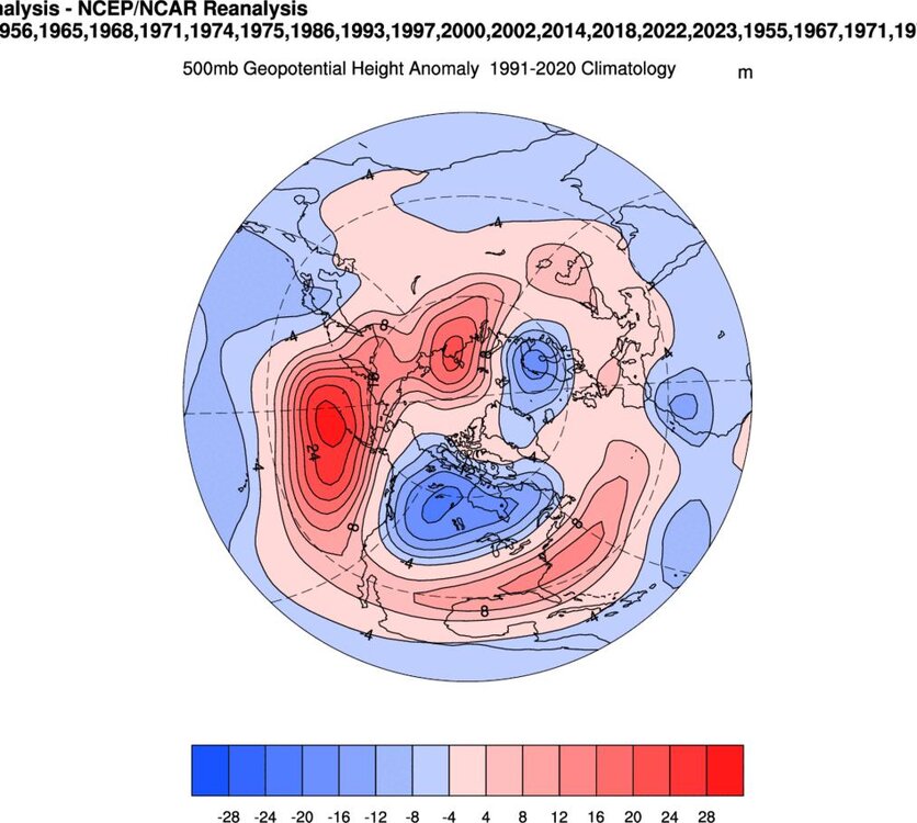
There are def. signs of a better north Pacific...I would bet my life that is what is driving some of these doomsday deviations.
-

Blowvember - and not named for wind potential
40/70 Benchmark replied to Go Kart Mozart's topic in New England
Starting to see some subtle signs of a potential light at the end of this proverbial Pacific-carnage tunnel, too. -
Blowvember - and not named for wind potential
40/70 Benchmark replied to Go Kart Mozart's topic in New England
I really don't think this winter is going to be a complete no-show again. Pretty confident in modestly better Pacific relative to last year providing some decent chances. -
What are your thoughts...similar, warmer, better?
-
2024-2025 La Nina
40/70 Benchmark replied to George001's topic in Weather Forecasting and Discussion
I ended up going +3 to +5 in Dec for the mid Atl and NE...hopefully I don't end up too cool....the potential translation of the MJO into phase 6 beyond mid month and towards the holiday is what kept me from really going bonkers. -
Generally agree, but think more WPO.
-
Blowvember - and not named for wind potential
40/70 Benchmark replied to Go Kart Mozart's topic in New England

-
-
Blowvember - and not named for wind potential
40/70 Benchmark replied to Go Kart Mozart's topic in New England
I think around 12/16 could begin a window, but just leery of can-kicking. -
2024-2025 La Nina
40/70 Benchmark replied to George001's topic in Weather Forecasting and Discussion
-
2024-2025 La Nina
40/70 Benchmark replied to George001's topic in Weather Forecasting and Discussion
Regardless of what La Niña does, I agree on that this year. -
-
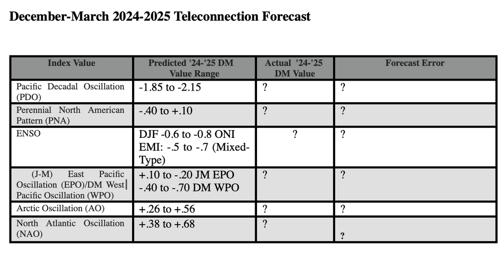
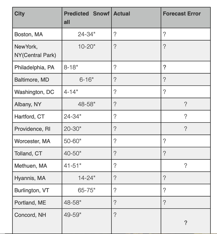
https://easternmassweather.blogspot.com/2024/11/using-past-forecasting-difficulty-to.html

-
2024-2025 La Nina
40/70 Benchmark replied to George001's topic in Weather Forecasting and Discussion
Yea, all I care about is the peak ONI value, anyway. -
2024-2025 La Nina
40/70 Benchmark replied to George001's topic in Weather Forecasting and Discussion
No, its very precarious...I agree. Toughest ENSO call in the 11 years I have been at this. -
2024-2025 La Nina
40/70 Benchmark replied to George001's topic in Weather Forecasting and Discussion
The issue I see is the trades are west, while the subsurface is east.....gonna need them to overlap a bit on the western periphery of 3.4. -
2024-2025 La Nina
40/70 Benchmark replied to George001's topic in Weather Forecasting and Discussion
Subsurface is neutral over the western half, which means it won't go Modoki....-1 to -2C over the eastern half. -
2024-2025 La Nina
40/70 Benchmark replied to George001's topic in Weather Forecasting and Discussion
Careful with the PDO....it's as much of a reflection of the past regime as it is a predictor of the future....ie the momentum is just as important. If begins climbing rather abruptly.... -
2024-2025 La Nina
40/70 Benchmark replied to George001's topic in Weather Forecasting and Discussion
Eh...I wouldn't say that yet. 2008 is a great ENSO analog and it racked up ONI by hanging out near peak for a relatively long duration, rather than reaching a low weekly. It was -0.1 at this point on the weekly and peaked at 0.8 ONI. -
2024-2025 La Nina
40/70 Benchmark replied to George001's topic in Weather Forecasting and Discussion
It could be an overlap...I know we like to distinguish using human constructs of arbitraty 30 days periods, but every now and then mother nature likes to moon us for doing so. -
2024-2025 La Nina
40/70 Benchmark replied to George001's topic in Weather Forecasting and Discussion
I don't mean this to be an ass, either...I would get it if there were resistance, but there really isn't. Like last year, I totally got it....but we are all generally on the same page here, so I think honing in on the magnitude, characterization, timing and length of any potential deviations would have more value at this stage. -
2024-2025 La Nina
40/70 Benchmark replied to George001's topic in Weather Forecasting and Discussion
Right on par with 2021. -
2024-2025 La Nina
40/70 Benchmark replied to George001's topic in Weather Forecasting and Discussion
I really don't see the value in posting volumes of support for a warm winter at this point....I mean, while you're at it, maybe dig up some tweets from scientists arguing that the world is round? I think at this point of the season, there is more value in thinking outside of the box and envisioning what, if anything could go "wrong" from a consensus perspective. -
2024-2025 La Nina
40/70 Benchmark replied to George001's topic in Weather Forecasting and Discussion
Anyone know what the final SAI/SCE were? -
2024-2025 La Nina
40/70 Benchmark replied to George001's topic in Weather Forecasting and Discussion
50mb, too....odd.