
Torchageddon
-
Posts
1,528 -
Joined
-
Last visited


.thumb.jpg.ad3a2e31d30aff035044689b311a0540.jpg)

-
It was -11C this morning, chill of ~-18C. Woke to see whiteouts. With those winds I wouldn't be shocked if there were blizzard conditions in rural spots. I prefer the wx I had 14 years ago where it was 24C and partly sunny.
-
There is a part missing, and I don't think he paused or stopped the recording in the middle of a tornado. I have props for one who stands outside in a wedge.
-
I just realized, why is the March 2012 heat blamed for all the damage when it was the cold in Apr that did the deed? Blame that solely. If it stays above seasonal, no freeze after, the woe would be averted but nature likes to 'balance things out' a bit too enthusiastically. I had an ask back then if it was possible to have a pattern with Mar 2012, then Apr/May being avg to above as well. I was told 'no'. With that kind of certainty of flip, would it be such a lock that an expert would bet their savings on Apr/May being below normal in the Great Lakes region?
-

2025-2026 ENSO
Torchageddon replied to 40/70 Benchmark's topic in Weather Forecasting and Discussion
Do you recall what articles they were? I have an interest in studying the March 2012 event like where the return rates touted came from, sigmas, air charts, etc. Maybe the jist of their thought was more extremes in the future that are outside the bell curve not literally similar March heatwaves like that; any pub that predicts such would be a rag IMO. Even with a rapidly warming climate I have a hard time believing March 2012 will be repeated much, if any in our lifetimes. Different date/place like the Pacific NW event in June 2021 sure. -
Why is it that heavy snow/blizzards don't convey well on camera - even 4K? Its never like seeing it IRL.
-
I was just looking into the 2021 Pacific NW heatwave recently; testing AI to see what it spit out regarding most extreme wx events and it was included. How sigmas and standard deviations come to be disseminated. The range is huge for a return rate but most certainly for events like the 2003 Euro heatwave, March 2012, and Jun 2021 they were 1 in 1000s of years magnitude using the current 30 year climate avg. If you use the pre-industrial climate benchmark (ice core sample data?) the 2021 heatwave might be a 1 in 150,000 year event!
-
Getting the worst lightning storm (frequent, prolific) I've experienced so early currently, just incredible. Its 4C and dropping, DP of 3C. 200+ strikes in 40 mins. 10mm in less than a hr I still have 5-8 inches snow on most grass with large snow piles. I don't know if its Mar 11 or the 12th but 14 years ago about this time I got one of my only severe t-storms since 2010 which crazily may be the only other frequent lightning event so early (kicked off the great March heatwave). I had sizable hail during that one, no hail in this ongoing storm.
-
So far under performing temp wise its 9C, sic at nox it was 7C not 13C! Getting the heavier rains and some thunder - steam whisping off the banks. TWN had a curr temp of 15C when I was really at 10C - disparity of uncouth proportions. Some flurries are possible tonight.
-
TWN adjusted Sat's high to 16C . The 'storms' came through earlier than expected; got 3-4 flashes with one flickering 15 times among the wimps.
-
Historic MI footage. Near the start you can see some of the ice getting pulled in to the vortex (looks like water with that low res video), another first! Also the longest weather streak I'm aware of may have just ended this afternoon (no confirmed violent tornadoes in MI since 1976 (West Bloomfield F4) or the Augusta 1977 one (unsure)).
-
The beginning of a series of rains has commenced. TWN has me at 19C/68F for Sat which would be seriously impressive with the snowpack and amt of ice on the lakes. I say 5% chance of verifying. WUN has 15C - I'll go with 16C prediction. If I somehow get to 20C (2%) that would be the 2nd earliest in modern records just 1 day behind Mar 8 2000 and 3 days ahead of Mar 4 2024. Storms are on tap during nox (overnight) with the temp rapidly rising to 13C. I'll be taking them seriously; my worst storms are now in early spring.
-
I haven't seen motion in a MI tornado like that before. The cloud of debris and dust at :37 looks like the condensation part. Fiercer than Dexter and Gaylord!
-
Insanity, wild footage and its from MI on a 2% risk Wedge otg.
-
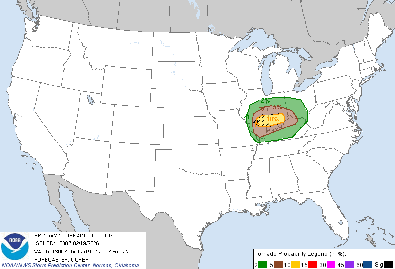
Day 1 Convective Outlook NWS Storm Prediction Center Norman OK 0700 AM CST Thu Feb 19 2026 Valid 191300Z - 201200Z ...THERE IS AN ENHANCED RISK OF SEVERE THUNDERSTORMS ACROSS SOUTHERN ILLINOIS AND SOUTHERN INDIANA... ...SUMMARY... Severe thunderstorms including a few tornadoes, large hail and damaging wind gusts are expected across parts of the Midwest and lower Ohio Valley today. Elsewhere, storms may produce strong wind gusts over parts of coastal south-central California early today. ...Midwest/Ohio Valley... A strong belt (80-100 kt at 500 mb) of cyclonically influenced westerlies will extend from the Southwest Deserts to the Ohio and Tennessee Valleys, with modest late-day trough amplification over the central Plains and Lower Missouri Valley. A related surface low will transition east-northeastward across the Lower Missouri Valley toward southern Lake Michigan tonight. A modestly moist warm sector will become increasingly established, characterized by mostly 50s F surface dewpoints, northward from the Mid-South across most of Illinois/Indiana into western/southern Ohio by early evening. A steady strengthening of southwesterly winds aloft will occur today, increasingly atop/coincident with the modestly moist warm-sector boundary layer. Long hodographs will be prevalent with upwards of 50-60 kt effective shear by afternoon. Around 200-350 m2/s2 0-1 km SRH is expected to be maximized on the southeast periphery of the surface low and in vicinity of the warm front, with the favorable zone including southern Illinois, southern Indiana and northern Kentucky. Increasing storm development should occur by late morning/midday across eastern Missouri, with maturing/increasingly surface-based storms near and just north of the I-70 corridor in southern Illinois by early afternoon. A semi-focused zone of peak severe/tornado potential may unfold generally near I-70, southward to near I-64, across southern Illinois and southern Indiana this afternoon through early/mid-evening. Sufficient forcing and boundary layer warming/mixing should allow for at least isolated semi-discrete development southward into the warm sector, and if so, relatively long-lived multi-hour supercells are plausible, with all hazards possible, but notably including heightened tornado potential, a few of which could be strong (EF2+). Given the limited early season moisture, the boundary layer will tend to become more hostile to surface-based storms and overall severe potential into mid/late evening. ...Coastal South-Central California... Bands of shallow convection will continue to move inland this morning. Weak destabilization, along with moderate mean boundary-layer winds just off the surface, could allow for locally strong to damaging gusts as the front progresses southeastward. ..Guyer/Grams.. 02/19/2026
-
Even the rec boxes are sizeably confused! My temp reminded at 1C so I didn't collect more ice, whew. Very wet today, maybe 20mm over the last 36 hr. I had a wave of real freezing rain at 9pm race through which coated all surfaces once I was -1C, a peek at what ick would've been in store had this precip been at night.


