

michsnowfreak
-
Posts
18,092 -
Joined
-
Last visited
2 Followers

About michsnowfreak

- Birthday 05/08/1983
Recent Profile Visitors


.thumb.jpg.ad3a2e31d30aff035044689b311a0540.jpg)


-

2026-2027 El Nino
michsnowfreak replied to Stormchaserchuck1's topic in Weather Forecasting and Discussion
If patterns are getting stuck, maybe we csn continue the luck with plentiful eastern troughing. -
2026-2027 El Nino
michsnowfreak replied to Stormchaserchuck1's topic in Weather Forecasting and Discussion
I am NO enso expert, not even close, but I remember a handful of years ago, they were hyping a STRONG (I cant even remember if it was Nino or Nina) event and it failed so bad it was either a cold/warm neutral. Not saying I think this El Nino fails, just that it seems way early to be SO confident in a strong one. -
2026-2027 El Nino
michsnowfreak replied to Stormchaserchuck1's topic in Weather Forecasting and Discussion
Actually had one of my favorite snow memories as a child. Snowstorm on Jan 14th. I was playing in the deep snow at my grandmas house (which is now my house). Around a foot of snow fell in 8 hours. Very dynamic quick hitting storm. -
I wouldnt consider that the impressive feature of this season, Id call it the annoying one lol. It certainly did cut off. After 4 consecutive colder than avg months, March will finish (I estimate) 13th warmest on record as well as 12th least snowy. This winter didnt follow a typical Nina in most aspects, but one thing that did hold true is the fact it was front-mid loaded. February was mostly snow-covered so i dont look at it as harshly as some do wrt below avg snowfall. But Nov-Jan was definitely where the fun was this winter. From salt supplies running short before mid-winter and salt/plow contractors begging for a break, to those same contractors wishing we had a few more runs by mid-March. Above avg snowfall seemed like a lock in January but then Feb-Mar was zzz. I am at 40.1" with DTW 39.4". Longterm avg is around 41" but the current 30-yr avg, high as its ever been due to the snowy 2000s/10s, is 45". While its certainly in the vicinity of an "average" snowfall season, theres no question that cold/snowcover exceeded expectations and snowfall fell short. Knowing how I love snowcover, it should come as no surprise the winter was an easy A but have to knock it to B for the zzzzz mid Feb thru Mar. April is very unpredictable so you never know.
-
2026-2027 El Nino
michsnowfreak replied to Stormchaserchuck1's topic in Weather Forecasting and Discussion
1991-92 wasnt bad here for a strong Nino. Average snowfall, a couple good storms. Mild overall, but multiple cold shots. -
I plan to get it! Ive done it with my backyard before, and it's really cool, but sometimes when theres too many details (esp my conifers grow so much each year)...sometimes a simpler, wider landscape is the best choice.
-
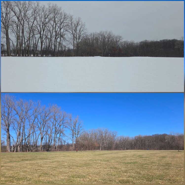
Sunny cold day today. Went to the park and took a pic of a field because i thought this was a cool winter/spring contrast pic.
-
Some flurries overnight. Few areas north of Detroit got a dusting. 24° this morning as the roller coaster temps continue.
-
2026-2027 El Nino
michsnowfreak replied to Stormchaserchuck1's topic in Weather Forecasting and Discussion
Neither am I. And after 2 cold winters (even though the cold surely would've been colder if this was 15+ years ago) its bound to be at a fever pitch. -
2026-2027 El Nino
michsnowfreak replied to Stormchaserchuck1's topic in Weather Forecasting and Discussion
This wasn't a typical la nina at all, but when looking at the season as a whole, it definitely was front-mid loaded here. It was great to have plenty of snow/snowcover right at kickoff during the coldest, darkest days. But I could've used one more snowstorm in late Feb/Mar, sun angle be damned. -
2026-2027 El Nino
michsnowfreak replied to Stormchaserchuck1's topic in Weather Forecasting and Discussion
Going to be interesting to see how the cansips evolves this summer. It had the cold winter lakes/east look last summer and fall while the other seasonals were mild. Its showing another cold winter in those same areas for 2026-27. -
2026-2027 El Nino
michsnowfreak replied to Stormchaserchuck1's topic in Weather Forecasting and Discussion
The ridge west, trough east alignment seems to be almost stuck. Not literally, of course it moves, but it has been dominant lately so no need to think it cant continue next winter. It was dominant for almost a decade it seemed if we look back just 11-12 years or so. And of course it goes without saying that the blazing SW is doing the heavy lifting for ranking conus winter warmth. Chuck and I have discussed, I personally dont worry about "cold" when it comes to snow. Its more about storm tracks. You can absolutely apply that to the Great Lakes and New England. Further south, of course its different. We have now had 2 cold winters in a row. With an El Nino coming Id be very surprised to see a 3rd cold winter in a row locally. The last 2 winters here have been cold and snowcovered with powder which is my favorite, but not gonna lie, with the biggest storm this winter 6.2" and biggest last winter 4.6", a milder winter would likely send more dynamic winter storms into this area. Historically its a mix, but for the last 3 decades, milder winters have produced some real dynamic snowstorms. -
2026-2027 El Nino
michsnowfreak replied to Stormchaserchuck1's topic in Weather Forecasting and Discussion
It was a great winter here as well. It was like the pre party to a fantastic 2005-2015. It was cold and dry west of the lakes though. -
2026-2027 El Nino
michsnowfreak replied to Stormchaserchuck1's topic in Weather Forecasting and Discussion
2002-03 like would definitely be an interesting outcome! -
Idk. No snowflakes in April is rare. But meaningful snow, thats another story.


