All Activity
- Past hour
-
By the way, there was no inland superiority last Thursday we had zero sea breeze -- one of my sensors actually recorded 93.7 at 4:30 pm on the north side of my house, but I don't record that number because it's near the roof of my house. But based on the 94 you listed there, maybe it was accurate? I still don't like the idea of being 4 degrees hotter than the airport especially on a westerly wind. I know I was hotter than JFK here in SW Nassau, I just can't say 4 degrees hotter. I went with the average of all 4 sensors I use and so went with 92. We were definitely hotter than JFK, I just can't say 4 degrees hotter. At least 92 for sure though. I'm not north of JFK, I'm 5 miles almost due east of JFK.
-
Not iffy at all since Harrison was 93° to the NW of the Newark ASOS. The LGA ASOS is right along the Western Sound or East River. So a westerly flow there is cooler. Go a few miles south to Corona and it’s a land breeze with compressional downslope warming off the Moraine. JFK is right on the water so they need WNW flow to avoid a cooling influence.
-
59 here at 11AM
-
By the way, there was no inland superiority last Thursday we had zero sea breeze -- one of my sensors actually recorded 93.7 at 4:30 pm on the north side of my house, but I don't record that number because it's near the roof of my house. But based on the 94 you listed there, maybe it was accurate? I still don't like the idea of being 4 degrees hotter than the airport especially on a westerly wind. I know I was hotter than JFK here in SW Nassau, I just can't say 4 degrees hotter. I went with the average of all 4 sensors I use and so went with 92.
-
Spittle cloud? Didn't know clouds could drool...
-
Ill be off line most of the rest of the day so wont be able to comment further. Lets first see if Newark can indeed make 100 early next week. It should feel 100+ but whether we can get to 100... 9 days in advance??? I've no reliable certitude.
-
a little iffy about 94 since it's 2 degrees higher than Newark. especially in Queens (that makes it 4 degrees higher than either LGA or JFK).
-
The micronets have been very reliable. They maxed out at 94° the other day a little higher than the airports which are cooler since all 3 ASOS stations are right on the water. Go just inland from the cooler airports and that is where the warmest urban areas are. June 12th high temperatures Corona, Queens…94° Brownsville, Brooklyn….94° Newark….92° Astoria, Queens…91° LGA….90° JFK….90° BDR…90° FRG….89° HVN…89° ISP…..88° NYC….87° HPN….87°
-
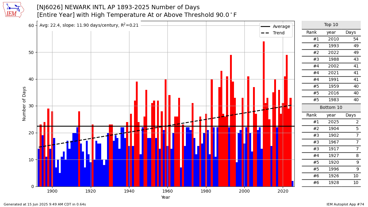
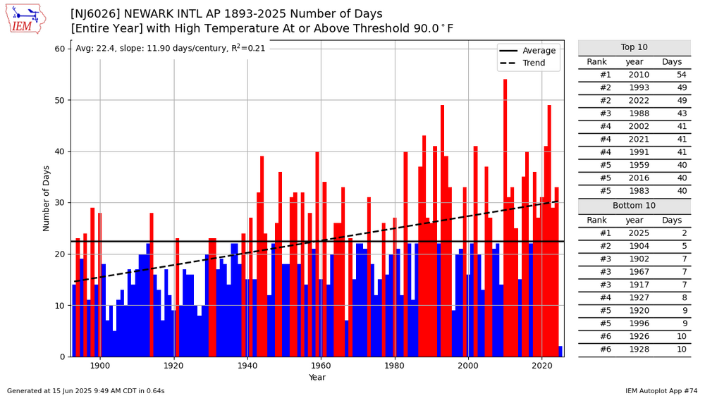
EWR comes closest to matching my personal experience which is that 2010 and 1993 were the two top summers.
-
oh we had massive wildfires that summer
-
it makes me wonder if those places actually undermeasured heat in 2010, LGA had 48 90+ days in 2010 which is going to be hard to match. 2010 was so far in excess of anything we have ever had, it was to summer what 1995-96 was to winter.
-
Our best derechos come with a stout EML, high pressure centered from Kentucky SE to Bermuda, and antecedent surface temps at or above 95°. We appear to have none of those in place.
-
Oh it was 1995
-
being wetter and onshore flow are directly connected right? so the more onshore flow you have the wetter it will be. I still maintain those micronets are overly cooked, there couldn't have been any 97.5 right near JFK or anywhere else in our area. I can accept 91-93 last Thursday but anything higher than that seems overly hot.
-
it's fun to pick a random august from the before times and see stretches of lows in the 50s
-
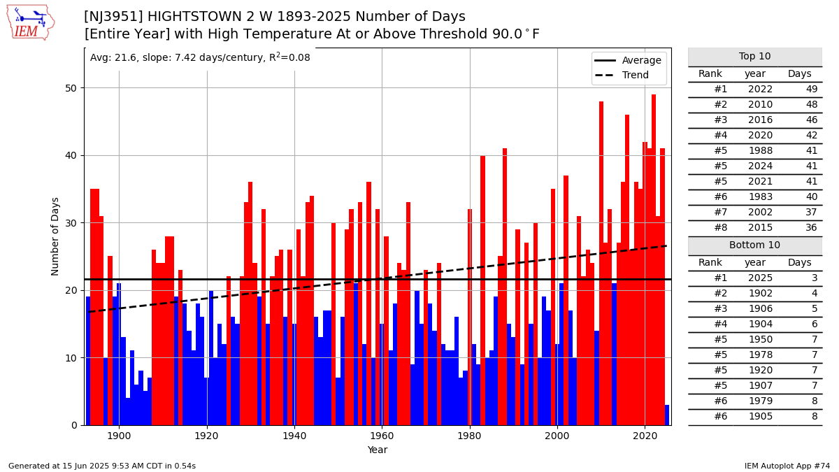
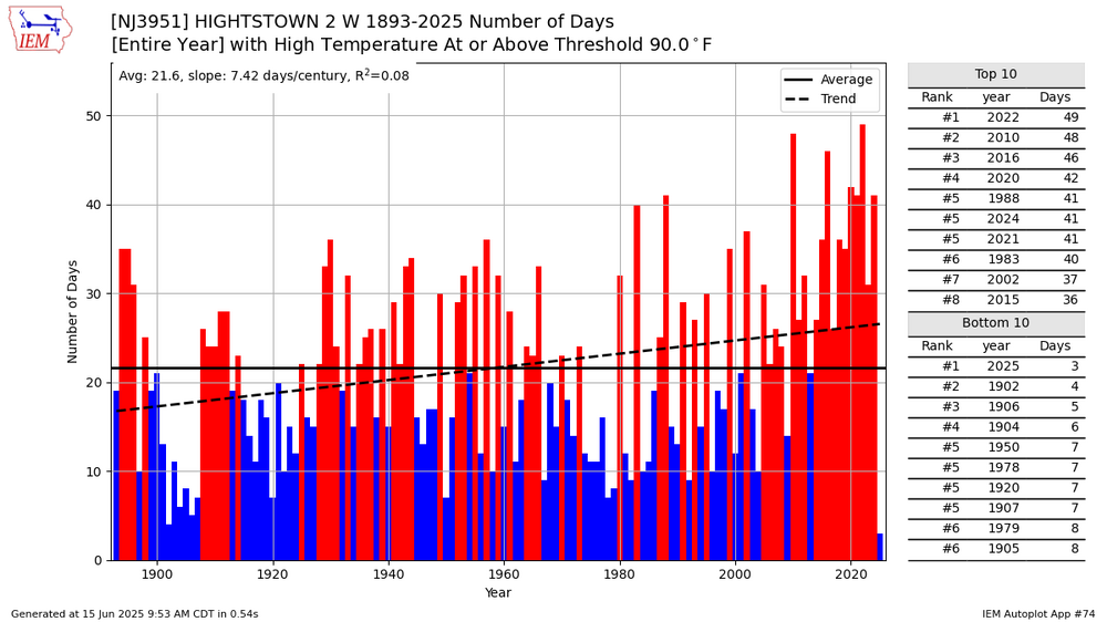
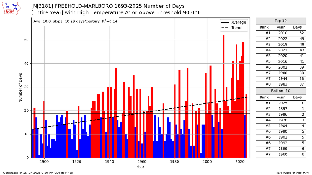
It’s been all about wind direction along with increasing rainfall and not traffic congestion. The strongest heat during the 2020s summers have been west of the sea breeze front in NJ. Too wet with plenty of onshore flow for the 2010 and 2011 record heat to be rivaled east of the Hudson. Notice how several spots in NJ nearly tied 2010 for 90° days as recently as 2022. One spot actually eclipsed the 2010 record for 90 days in 2022. Even Newark has had sea breeze influence compared to Highstown which set the their all-time 90° day record in 2022 ahead of 2010. https://mesonet.agron.iastate.edu/plotting/auto/?_wait=no&q=74&network=NJCLIMATE&station=NJ3951&season=all&dir=above&var=high&threshold=90&year=1893&_r=t&dpi=100&_fmt=png
-
-
I'd like it to only rain at night if possible lol My flowers are not in good shape sunshine during the day and rain at night!
-
Three months? That's crazy. We definitely need a drying out period right now, but we also don't want to go into another drought during the summer. How about a happy medium? Those of us with gardens care about getting enough rain.
-
Yeah we were like that yesterday. Had to go over the mountains here in Frederick to Middletown. The sight of the smoke in the valley was present: Mind you today we are in England with this spittle cloud cover and musty temps.
-
I thought 1998 had a lot of rain because it was a super el nino, 2002 was the really dry/hot year, check it out.
-
I think there was a big drought in 1998 that lasted July and August and doesn't seem to have spiked
-
No I turned on my space heater in my bedroom as late as last night and early this morning I also use it to dry out the air when it's rainy outside. air conditioning costs are much less than heating costs anyhow (I only use window units here).
-
also if you look at big heat summers like 1991, 1993, 1995, 1999, 2002, 2010 and 2011 you'll notice it wasn't as high in those specific years, so it makes me think it's more connected to rainfall rather than heat.
-
thats crazy but I have a theory, did you see how low it was in 2004? this dip happened when our summers and years in general became rainier. It was higher when our summers and years were drier.