All Activity
- Past hour
-
There's a few demons in here for sure. I can understand not being 95/75...but 80 and low humidity?
-
Ha.... better than "flawless" that's a neat trick... But you know, in quantum mechanics there can apparently be to concurrent states so ... maybe you can have both perfect and perfect Haven't looked at the weekend yet
-
It's -SAD, or "summer SAD" in psychobabble, Scott. (he/she is not the only one I suspect suffers that in here )
-
Sunday may be even better
-
no matter what the species... they're called 'widow makers' for a reason. heh
-
Thursday's a top 10 ...maybe top 5 day if using these raw FOUS grid numbers ( NAM). 7 kts NW down sloping compression under +3 or +4 850 mb. Mixing probably limited to 900 or 875 but with unadulterated early solar max irradiance at 100%, the sounding will been dry air unstable to 900 feet or so and it will be warmer than standard adiabat in the lowest layer That's approaching flawless.
-
Hard to imagine ghouls like Ineedsnow prefer 45 and rain over this. You wonder what went on during their childhood.
-

2026-2027 Strong/Super El Nino
PhiEaglesfan712 replied to Stormchaserchuck1's topic in Weather Forecasting and Discussion
If that's the case, then I guess you're pretty much certain on a flip to +PDO. Probably going to mean an AN temperature winter, but I'd take my chances of this (both 1982 and 2015 had a major snowstorm), rather than a deep -PDO robust el nino like 1972 or 2023. -
78° at noon I’ve been waiting for this for 7 long months.
-

2026-2027 Strong/Super El Nino
40/70 Benchmark replied to Stormchaserchuck1's topic in Weather Forecasting and Discussion
Precisely what we don't want. -
 AnEndlessMaze changed their profile photo
 -
When I used to work as a camp counselor over the summer there were a few kids sitting under a tree during lunch. I didn't see this happen because I was inside with a few of the kids, but a large limb fell out of nowhere and just missed the kid. Extremely scary stuff. I believe it was a giant oak but it was rotting...the town quickly came in and they either completely took it down or significantly trimmed it
-
2026-2027 Strong/Super El Nino
40/70 Benchmark replied to Stormchaserchuck1's topic in Weather Forecasting and Discussion
No chance this ends up like 2009-2010. 1982 is the ceiling, 2015 the floor. -
Hopefully these big rips verify later today
-
They are messy but the shade is great. We have one next to our house that I like and curse at the same time.
-
2026-2027 Strong/Super El Nino
40/70 Benchmark replied to Stormchaserchuck1's topic in Weather Forecasting and Discussion
Yea, I do not agree with @mitchnick...I think the modoki index is going to be pretty useless this season...TBH, I wonder if that is losing utility like the ONI as a byproduct of CC. I bet the key is going to be watching the relationship between the RONI and ONI...the larger separation (assuming RONI is lower), the more ill-defined the Aleutian low/se trough will be, and the shittier the eastern winter. We may need to come up with some sort of index for that. -
OMG
-
Dry begets dry.
-
80 here - warmest since April 23
-
Records: Highs: EWR: 94 (1949) NYC: 90 (1980) LGA: 90 (1955) JFK: 84 (1980) Lows: EWR: 38 (1966) NYC: 34 (1891) LGA: 42 (1978) JFK: 41 (2002) Historical: 1834: A group of tornadoes in Virginia killed three people. The twisters carved a path from near Victoria to south of Petersburg to just south of the James River. The damage path was reportedly one mile wide in places. (Ref. Wilson Wx. History) 1917 - The same storm which a day earlier produced eight inches of snow in the Texas panhandle, produced a foot of snow at Denver CO, their heaviest snow of record for the month of May. (David Ludlum) 1930 - The temperature at College Park, VA, soared from 43 degrees to 93 degrees to begin an exceptional heat wave. (Sandra and TI Richard Sanders - 1987) 1933: An estimated F4 tornado cut a 35-mile path from near Brent into Shelby County, Alabama. The town of Helena, AL was especially hard hit, as 14 people died. The tornado roared through Helena at 2:30 am. 1960: A dust devil on the western shore of ME’s Lake Auburn lifted a 1,000 pound ice boat and turned it topsy-turvy. A nearby clothes line was unscathed. (Ref. Weather Guide Calendar with Phenomenal Weather Events 2011 Accord Pub. 2010, USA) 1961: 19 tornadoes touched down leaving more than 30 people dead in eastern Oklahoma. Hardest hit was the town of Wilburton, where 13 people were killed, and over 800 homes and buildings were either damaged or destroyed. (Ref. Wilson Wx. History) 1975: Heavy rains totaled 2 to 5 inches in the northern Black Hills of South Dakota flooding many streams. Higher elevations such as the Lead area received over a foot of snow. Rapid City narrowly missed being struck by a tornado as the storm's damage path began about two miles east of Rapid City. The Rapid City airport did report a gust of 53 mph with Ellsworth Air Force Base receiving a gust to 70 mph. (Ref. Wilson Wx. History) 1978: Heavy wet snow of around 24 inches collapsed an office and hotel in Boulder, CO. Many cars were abandoned across the city. Denver received 14 inches with Evergreen and Golden receiving a foot. Snowfall totaled 12.4 inches at Stapleton Airport in Denver, CO and 7.2 inches at Cheyenne, WY. (Ref. Wilson Wx. History) 1981: Mobile, AL had its worst flash flooding ever as thunderstorms unloaded 8 to 16 inches of rain over the metro area in a couple of hours. Damage totaled $36 million dollars. (Ref. Wilson Wx. History) 1982: Severe flash flooding hit parts of southwest Oklahoma and the western parts of North Texas. The hardest hit area was around Lawton, where 4 to 5 inches of rain fell in just 90 minutes. The weight of the heavy rain caused the roof of a shopping mall to collapse, killing one person and injuring two others. Flooding also occurred in north Texas, where several roads in Wichita, Clay, and Archer Counties were closed by high water that spilled over the banks of area creeks. (Ref. Wilson Wx. History) 1987 - Unseasonably hot weather prevailed in the western U.S. A dozen cities in California reported record high temperatures for the date. Afternoon highs of 93 degrees at San Francisco, 98 degrees at San Jose, 100 degrees at Sacramento, and 101 degrees at Redding, were the warmest of record for so early in the season. The high of 94 degrees at Medford OR was also the warmest of record for so early in the season. (The National Weather Summary) 1987 - Parts of the western U.S. were in the midst of a blistering May heat wave. The reading of 100 degrees in Downtown Sacramento CA was their earliest of record. Sacramento CA established daily record highs on nine of eleven days between the 4th and the 14th. (The Weather Channel) 1988 - A stubborn low pressure system continued to drench the eastern U.S. with rain. Thunderstorms again produced large hail in North Carolina. (The National Weather Summary) 1989 - Thunderstorms swept across Georgia and the Carolinas during the late afternoon and evening hours spawning seventeen tornadoes. A tornado at Toccoa GA injured 15 persons, and a tornado at Chesnee SC killed two persons and injured 35 others. Five tornadoes in North Carolina accounted for five deaths, 88 injuries, and sixty million dollars damage. Thunderstorms also produced baseball size hail at Lake Murray SC, and wind gusts to 78 mph at Brooklyn MD. (The National Weather Summary) (Storm Data) 1990 - A strong Pacific cold front moving rapidly inland caused weather conditions at the east end of the Strait of Juan de Fuca in Washington State to quickly change from sunny and calm to westerly winds of 60 mph and ten-foot waves. Three recreational fishing boats capsized in heavy seas off Port Angeles resulting in five deaths. In California, temperatures soared above 90 degrees across much of the state. The high of 101 degrees in downtown Los Angeles was eight degrees hotter than their previous record for the date. (The National Weather Summary) (Storm Data) 1995: A supercell thunderstorms brought torrential rains and large hail up to four inches in diameter to Fort Worth, Texas. This storm also struck a local outdoor festival known as the Fort Worth Mayfest. At the time the storm was the costliest hailstorm in the history of the US, causing more than $2 billion in damage. 2002: On a scary note, a convoy of experienced storm chasers, including Matt Sellers and Shane Adams, had a near-miss with a tornado which touched down nearly on top of them near Lakeview, TX as they were following the storm that had earlier struck the town of Happy. No chasers were injured during the encounter, but several had damage to their vehicles. In addition, the University of Massachusetts 10-centimeter Mobile Doppler Radar was entangled in downed power lines near Lakeview. (Ref. Wilson Wx. History)
-
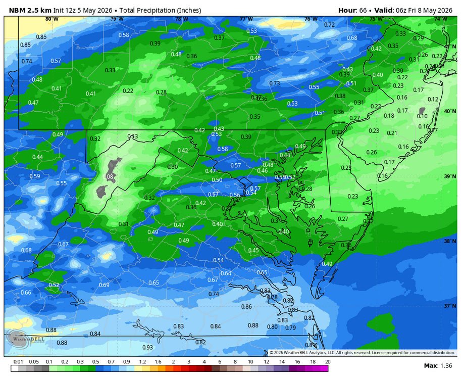
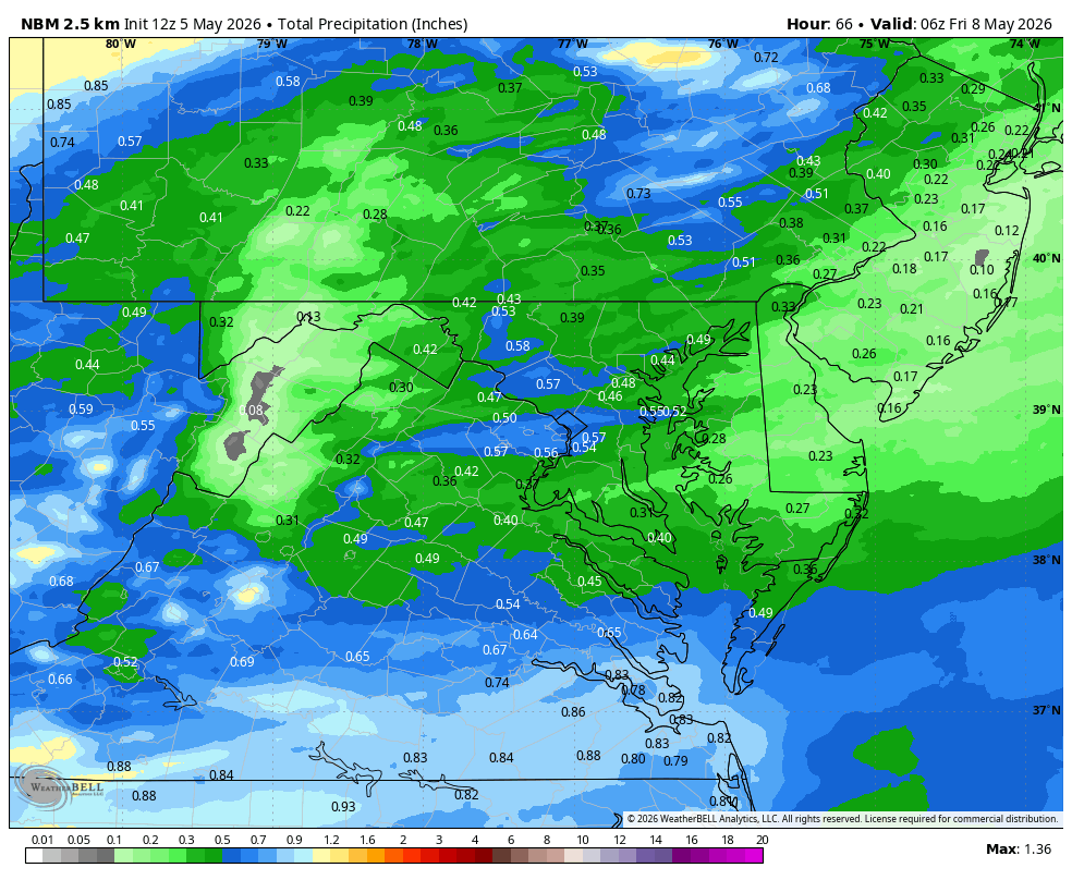
Yeah but when that .1-.25 was forecasted to be 1"+ less than 48 hours ago...
-
Tomorrow night really went the way of Stein. Like .25 or less for many . A few days ago it was over 1”. Lawn pretty dusty mowing
- Today
-
If I get another .10 to .25 I will take it. Beggars can't be choosy....
-

2026-2027 Strong/Super El Nino
GaWx replied to Stormchaserchuck1's topic in Weather Forecasting and Discussion
1982-3 was east based and was an amazing winter snow wise in much of the SE US (E AL to NE NC)! -

-
WB 12Z NBM thru Th.