All Activity
- Past hour
-
I'd take that
-
weird as hell
-
So we fail upwards then.
-
How did you get a larger gif to post?
-
The Canadian keeps future Imelda offshore, but the massive ridge over the top blocks its escape and runs it up the coast. Funky.
-

Invest 94L—80% 2 day and 90% seven day odds of development
GaWx replied to WxWatcher007's topic in Tropical Headquarters
Other 12Z: Icon goes OTS again JMA hints at OTS but not sure since only to 72 UKMET goes OTS again like the Icon although it goes further NW than prior runs before going OTS NEW TROPICAL CYCLONE FORECAST TO DEVELOP AFTER 42 HOURS FORECAST POSITION AT T+ 42 : 23.3N 76.7W LEAD CENTRAL MAXIMUM WIND VERIFYING TIME TIME POSITION PRESSURE (MB) SPEED (KNOTS) -------------- ---- -------- ------------- ------------- 1200UTC 28.09.2025 48 24.2N 76.7W 1007 33 0000UTC 29.09.2025 60 25.2N 77.4W 1004 34 1200UTC 29.09.2025 72 26.7N 77.8W 1003 38 0000UTC 30.09.2025 84 28.2N 77.6W 1001 36 1200UTC 30.09.2025 96 28.9N 78.5W 996 42 0000UTC 01.10.2025 108 28.7N 77.8W 994 40 1200UTC 01.10.2025 120 28.5N 76.6W 992 38 0000UTC 02.10.2025 132 28.7N 74.3W 991 46 1200UTC 02.10.2025 144 28.9N 72.2W 991 54 0000UTC 03.10.2025 156 28.7N 69.6W 992 63 1200UTC 03.10.2025 168 28.6N 68.4W 995 52 -
What are you talking aboot?
-
A lot of yall are really trying to get banned.
-
The Canadian, as usual, is funky.
-

September 2025 OBS-Discussion centered NYC subforum
donsutherland1 replied to wdrag's topic in New York City Metro
The consistency has been remarkable. Smallest Mean Temperature Standard Deviation for September (through September 25th for 2025) for Central Park: 1. 1968 3.43° 2. 2025 3.75° (10th smallest difference between the mean temperatures for the first and second halves of September) 3. 1870 3.81° (6th smallest difference between the mean temperatures for the first and second halves of September) 4. 2024 3.94° 5. 1908 4.08° -
 CMC stalls it, heads east as it interacts with Humberto, then gets left behind and landfalls into NC as an strong intensifying hurricane
 -
 Not to mention the onshore flow. A further south track with that flow over Charleston would be very bad. The Low Country is called that for a reason (I used to live in SC).
 -
I’m very worried. This has high end flood potential written all over it even if it stalls just off the coast
-

Invest 94L—80% 2 day and 90% seven day odds of development
eyewall replied to WxWatcher007's topic in Tropical Headquarters
I am starting to wonder about an eventual stall as this thing gets near the coast or perhaps a little inland. -

Invest 94L—80% 2 day and 90% seven day odds of development
wthrmn654 replied to WxWatcher007's topic in Tropical Headquarters
It will though be a wet storm so that's basically a given -
It’ll be an interesting test case for sure if the whole N PAC is warm vs the 2/3 of the western Pacific.
-
Invest 94L—80% 2 day and 90% seven day odds of development
wthrmn654 replied to WxWatcher007's topic in Tropical Headquarters
Something I don't think anyone has talked about/ mentioned but this L has been tracking against guidance, nearly due west since at least 18z yesterday... i mean just look at the actual track versus modeling at 18z with each x. Being 00,06,12z actual placement...... this will likely dictate storms overall intensity the closer to Florida it gets along with all the islands is gotta cross. With 12z runs showing this likely a TS possibly barely a Cat 1 maximum strength wise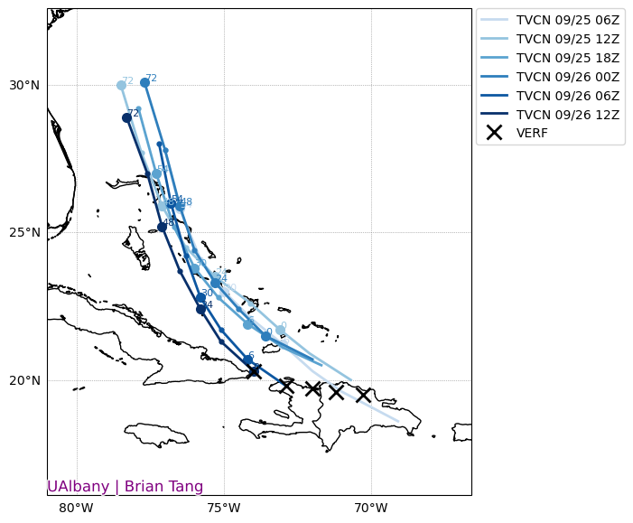
-
Yeah this looks like a low end wind event current compared to other events.
-

September 2025 OBS-Discussion centered NYC subforum
the_other_guy replied to wdrag's topic in New York City Metro
This has to be one of the most consistently warm Septembers I remember. Not hot…just warm -
Yes, the steering current is very weak. That's why we have a cutoff low in the region that just meanders. This run kind of parks the tropical system in SC instead of further north. Still a lot of rain but as Steve said this won't be a powerhouse of a storm. Still a ways to go with this storm obviously. Sent from my SM-G998U using Tapatalk

-
Exciting times in New England.
-
You can see pretty easily why the establishment of an inner core matters here. On the 06z GFS run, the core is weaker and less structurally sound, and as a result it’s easier for dry air to get entrained. The result is a slowly intensifying storm (take note) on landfall. 12z has a symmetrical core, which not only makes it stronger but closes off the eye from dry air entrainment. The result is a substantially stronger hurricane that is likely intensifying more robustly on landfall. I can’t emphasize enough how important it’ll be to get a well defined LLC so that the models can figure this out. I think an east coast strike is highly likely at this point given the GFS/Euro and their ensembles overwhelmingly overlapping in the general upper level steering features.
-

2025-2026 Fall/Winter Mountain Thread
Maggie Valley Steve replied to Buckethead's topic in Southeastern States
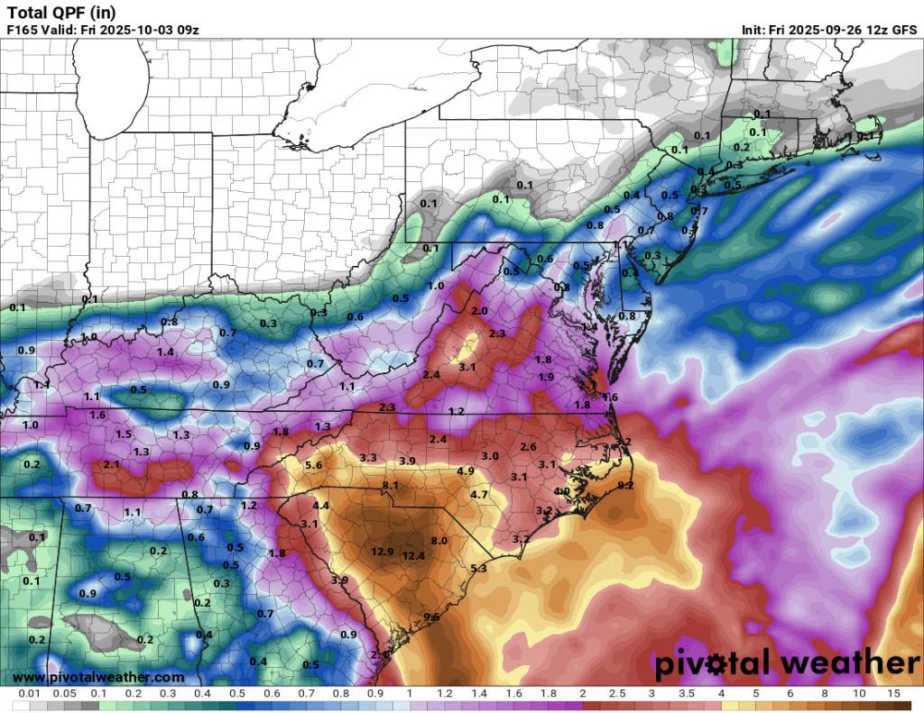
The 12Z GFS solution suggests our Region could receive 3 to 5 inches of rain the next 6 days. There does not appear to be much of a wind threat via the GFS. We could manage that. -

2025-2026 ENSO
40/70 Benchmark replied to 40/70 Benchmark's topic in Weather Forecasting and Discussion
This is what I was saying. - Today
-
Are there examples of large, advanced technology countries that have transitioned almost completely away from fossil fuels?