All Activity
- Past hour
-

2025-2026 ENSO
PhiEaglesfan712 replied to 40/70 Benchmark's topic in Weather Forecasting and Discussion
MAM 2025 ONI (NOAA): -0.1 MAM 2025 RONI: -0.53 May 2025 PDO: -1.71 -
You can search anywhere if you follow instructions...
-
First tick of the year pulled off me. How many more to come.
-
Debated this myself earlier. If I open windows it won't be quite cool enough, so put the inverters on 64 and Quiet. With the outside temps relatively cool they won't run a lot, but the air circulation when they do is worth it.
-
-
MJO looks like it is 1/2 to 2/3 magnitude of this time of year in 2022, and off by about 8-12 days for timing. So it's not perfect. It's not like the years have been super different and just snapped into place. Jan 2022 and Jan 2025 both finished super cold, even though the cold entered the US from slightly different origins, and again the timing is off.
-

2025-2026 ENSO
40/70 Benchmark replied to 40/70 Benchmark's topic in Weather Forecasting and Discussion
Although, I think 2022-2023 with a bit less extreme troughing out west would have been pretty good...I doubt the RNA would be that extreme again. -
KODI HTPC
-
NICE! Quess: Where is the Cold Front? It's going to be a Hot Summer.
-
2025-2026 ENSO
40/70 Benchmark replied to 40/70 Benchmark's topic in Weather Forecasting and Discussion
2022...great, said no one east of the Mississippi except for @snowman19.... -
As much as Kevin pushes back against it, tonight really is, a cool the house, with fans and open windows kind of night.
-
Yup...was telling my friend earlier, we probably want tomorrow to have very little in the way of storms with Friday holding the better potential. I wish shear was a tad stronger but I'll take some intense pulse type storms.
-
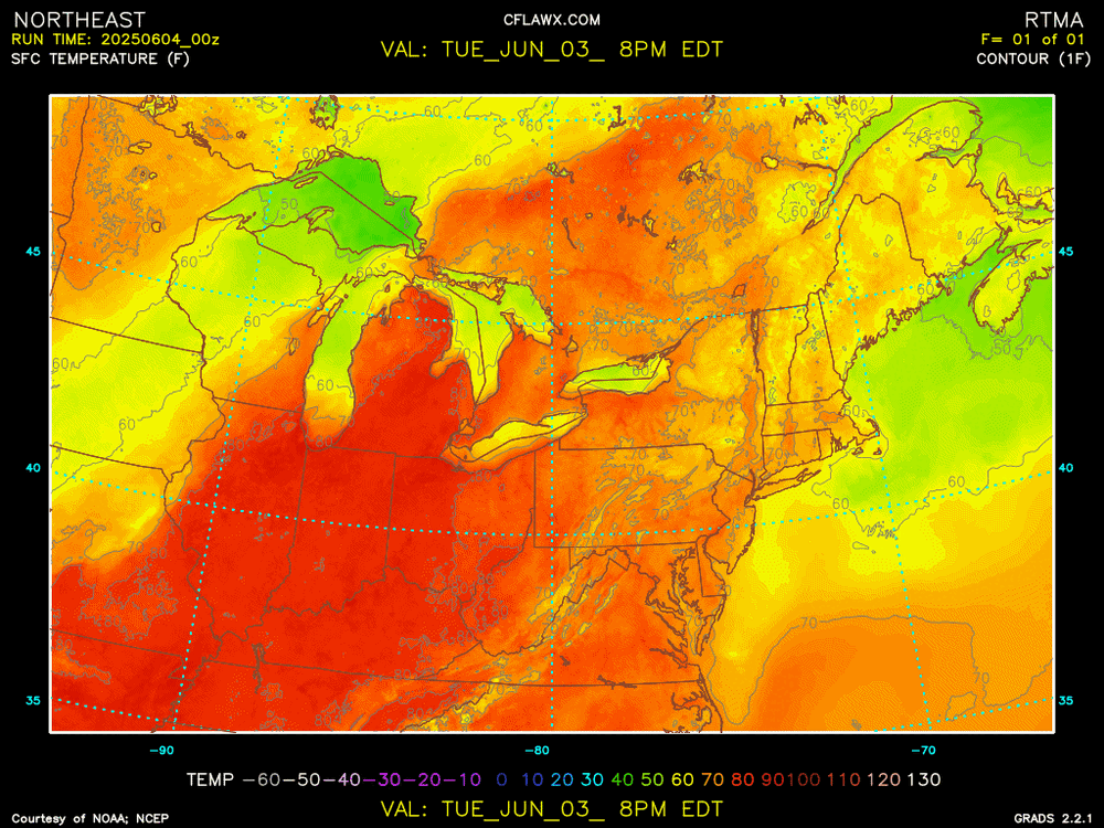
The Spring globally had at least a passing resemblance globally to 2022. That's consistent with my idea of a pretty wet Summer in the deserts of North America (MX/SW US). The big highs from Japan due east and off the SE US, with low pressure Aleutians to North Dakota are similar. Southern Hemisphere and Asian Plateau setups are pretty different but those aren't super important for us in the Summer in the US. MJO has a passing similarity for late May in 2022 v. 2025 in terms of the wind anomalies by the tropics at about a 1-2 week difference for timing (green on the images for 15N-15S)
-
Friday has that look, where we don't overturn the air mass on Thursday and end up doing the marginal risk on Friday instead.
-
500 temps drop slightly tomorrow in the aftn
-
Even keeps that pseudo EML through Friday. The shear is meh but that's some pretty hefty CAPE for these parts (MLCAPE 2500-3000). But yeah tomorrow probably has some capping issues but that weak boundary could be enough to set something off, especially early evening. Friday I think may have a bit more potential for storms.
-
Edit, not sure what happened but the run was off. Yeah it looks decent. EML tickles.
-
Yeah soundings are decent, but wonder if it’s capped a bit.
-
00z looks lame
-
NAM continues to be quite interesting late tomorrow afternoon and now during the evening
-
Weekend looks good overall in SNE. Sprinklers on Saturday as we dream of Steinifornication
-

2025-2026 ENSO
Stormchaserchuck1 replied to 40/70 Benchmark's topic in Weather Forecasting and Discussion
Asia and the Middle East are really hot for the next 1-2 weeks. Big +AO pattern. The AO positive in June will be the 4th straight +AO month, and some of these >+1 daily readings we have seen are amongst the highest lately. Surprisingly, it doesn't roll forward to anything significant for the Winter. -
Saturday will have some sun
- Today
-
This is a warm season AFD. Hazy, quiet, warm conditions after some record/near record temps. Summer vibe tonight. .NEAR TERM /THROUGH THURSDAY NIGHT/... As of 703 PM EDT Wednesday...Mostly clear skies with some residual wildfire smoke will likely yield a colorful sunset tonight across the North Country. We likely tied or broke a few temperature records today looking at observations but we will wait until 8 PM to begin sending out any record statement as we want to ensure the data is correct. Otherwise, it`ll be a quiet night across the region with increasing cloud cover toward morning as a cold front approaches the region.
-
I sure hope not! Wanted to get down there to tour it before Trump shuts it down.


.thumb.png.4150b06c63a21f61052e47a612bf1818.png)


